Silverstone is a village and civil parish in Northamptonshire, England. It is about 4 miles (6.4 km) from Towcester on the former A43 main road, 10 miles (16 km) from the M1 motorway junction 15A and about 12 miles (19 km) from the M40 motorway junction 10, Northampton, Milton Keynes and Banbury. The population of the civil parish at the 2011 census was 2,176. The A43 now bypasses to the south-east of the village.
Byfield is a village and civil parish forming part of West Northamptonshire, England. The population of the civil parish at the 2011 census was 1,277.
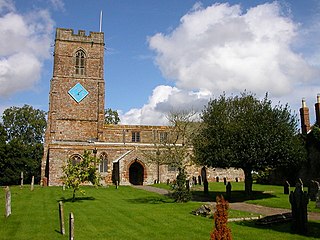
Whilton is a village and a civil parish in the English county of Northamptonshire. The population at the 2011 Census was 271. The village is in West Northamptonshire. Whilton is 75 miles (121 km) northwest of London, 9+3⁄4 miles (15.7 km) west of Northampton and 15+1⁄2 miles (24.9 km) southeast of Rugby. The village lies 4+1⁄2 miles (7.2 km) east of the nearest town of Daventry. The nearest railway station is at Long Buckby for the Northampton loop of the West Coast Main Line which runs between Rugby, Northampton and London. The nearest airport is Birmingham Airport. Whilton gives its name to the nearby Whilton Locks and Whilton Marina on the Grand Union Canal.
Thornby is a village and civil parish in West Northamptonshire in England. It has a Manor house. At the time of the 2001 census, the parish's population was 162 people, increasing to 189 at the 2011 Census. The village is bisected by the A5199 road between Northampton and Leicester and about 11 miles (17.7 km) north-west of Northampton town centre. It is about 1½ miles south of a junction with the A14 road which joins the M1 Motorway and M6 junction at Catthorpe with Felixstowe, Suffolk.

Spratton is a village and civil parish in the English county of Northamptonshire. The local government authority is West Northamptonshire. Before changes in 2021 it was governed by Daventry District Council. At the time of the 2001 census, the parish's population was 1,099 people, increasing to 1,150 at the 2011 Census. Spratton is 7.1 miles north of Northampton, 6.5 miles from Long Buckby and 11.4 miles from Daventry. The village is situated on the A5199 road.
Sibbertoft is a village and civil parish in West Northamptonshire in England. At the time of the 2001 census, the parish's population was 343 people, increasing to 462 at the 2011 Census.
Preston Capes is a village and civil parish in West Northamptonshire in England. The population at the 2001 census was 188, including Canons Abbey and increasing to 216 at the 2011 census.
Overstone is a village and civil parish in West Northamptonshire, England. At the time of the 2001 census, the parish's population was 650 people, increasing to 741 at the 2011 Census.

Old is a village and civil parish in West Northamptonshire, England. At the time of the 2001 census, the parish's population was 308 people, and the population increased to 490 at the 2011 Census.

Holdenby is an English village and civil parish about 5.5 miles (8.9 km) north-west of Northampton in West Northamptonshire. The parish population measured by the 2011 census was 170. The village name means "Halfdan's/Haldan's farm/settlement".

Flore is a village and civil parish in West Northamptonshire in England.
Cold Ashby is a village and civil parish in West Northamptonshire in England. At the time of the 2001 census, the parish's population was 255 people, increasing to 278 at the 2011 census.

Hartwell is a village and civil parish in West Northamptonshire, bordering Buckinghamshire. The village is next to Salcey Forest and the M1 motorway. It is 7 miles (11 km) south of Northampton and 13 miles (21 km) north of Milton Keynes.
Old Stratford is a village and wider civil parish in the south of the English county of Northamptonshire. The population of the civil parish at the 2011 Census was 1,935. The 'Stratford' part of the village name is Anglo-Saxon in origin and means 'ford on a Roman road'. The Roman road in this sense is the Watling Street that runs through the middle of the village.
Ashley is a village and civil parish in the North Northamptonshire, England, about 4 miles (6.4 km) northeast of Market Harborough, Leicestershire and 5 miles (8.0 km) west of Corby. The population of the civil parish at the 2011 census was 224. The village is near the River Welland, which forms the border with Leicestershire. The Roman road called Via Devana in the part from Ratae to Duroliponte ran just north of the village.
Blakesley is a village in the West Northamptonshire, England. It is about 5 miles (8 km) west of Towcester. It is about 400 feet (120 m) above sea level according to Ordnance Survey. North-west of Blakesley, and now contiguous with it, is the hamlet of Quinbury End.
Bradden is a village and civil parish in West Northamptonshire, England, about 4 miles (6.4 km) west of Towcester. According to the 2001 census it had a population of 179, falling to 149 at the 2011 census.
Middleton is a village and civil parish in North Northamptonshire close to the county boundary with Leicestershire. At the time of the 2001 census, the parish's population was 328 people, increasing to 414 at the 2011 Census.
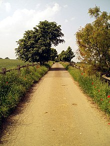
Slapton is a small village in Northamptonshire, England, about 4 miles (6.4 km) from Towcester and the same from Silverstone. It is close to the A43 road which links the M40 motorway junction 10 with the M1 junction 15A at Northampton. Central London is about 60 miles south of M40 junction 10. At the 2011 Census the population remained less than 100 and was included in the civil parish of Whilton.
Deenethorpe is a village and civil parish in North Northamptonshire, England. It is situated north-east of Corby and near the A43 road between Corby and Stamford. Nearby villages are Deene located 1.9 miles (3.1 km) to the North-West, Bulwick 1.9 miles (3.1 km) and Upper Benefield 2.5 miles (4.0 km) South-East to Deenethorpe.