Woodstock, Pembrokeshire

Last updated

Woodstock
Hamlet of Woodstock - geograph.org.uk - 1729095.jpg
The main road through the village
Pembrokeshire UK location map.svg
Red pog.svg
Woodstock
Location within Pembrokeshire
OS grid reference SN020255
Community
Principal area
Preserved county
Country Wales
Sovereign state United Kingdom
Postcode district SA
Police Dyfed-Powys
Fire Mid and West Wales
Ambulance Welsh
UK Parliament
Senedd Cymru – Welsh Parliament
List of places
UK
Wales
Pembrokeshire
51°53′35″N4°52′41″W / 51.893°N 4.878°W / 51.893; -4.878

Woodstock (Welsh : Wstog) is a rural village in the southern foothills of the Preseli Mountains in the community and parish of Ambleston, Pembrokeshire, Wales. There is a built-up area on the B4329 former turnpike, and another down a side-road, close to, but with no road access to Llys y Fran reservoir.

Contents

Name

According to a pre-1850 parish map, the area on the B4329 was named Woodstock Slop, and the other just Woodstock. [1] The Welsh name does not appear on parish or Ordnance Survey maps before the 20th century, [2] but the Methodists were using the name in 1913. [3]

History

Close to Woodstock village is Woodstock Ring, a prehistoric earthwork containing the possible traces of a building within, indicating habitation in prehistoric times. [4]

Woodstock has been described as a modern village [5] but the manor of Woodstock (along with that of Ambleston) was bequeathed by Sir James Perrot, son of Sir John Perrot to Francis Perrot, and then in 1642 to his nephew Herbert. In 1761 Herbert's descendant Sir John Perrot sold Woodstock to Admiral Thomas Tucker. The manor is mentioned many times in respect of indentures, grants and tenancies in the 17th and 18th centuries. In 1717 Woodstock mill was leased to yeoman Lewis John. [6]

Richard Fenton, in 1811, recorded passing through Woodstock, stating that the name came from an extensive manor owned in early times by Huko Hywel, whose daughters married Normans, and that the manor eventually came into the possession of the Perrott family. [7]

James Hartley Jones, whose name appears on the Ambleston War Memorial, is recorded as having enlisted at Woodstock (he lived in the nearby hamlet of Wallis) early in World War I. [8]

Chapel

Woodstock C.M. Chapel Woodstock Chapel - geograph.org.uk - 470876.jpg
Woodstock C.M. Chapel

Fenton noted that a chapel of ease to Ambleston parish existed in the village, but had long since ceased to exist, and the cemetery had been ploughed. [7]

Woodstock Calvinistic Methodist Chapel was founded by the Reverend Howel Davies. [9] It was built in 1755, the first Methodist chapel in Pembrokeshire, and was rebuilt in 1809 and restored in 1890. [10] The chapel is a Grade II listed building. [11] [12]

School

A school was opened in Woodstock in 1869 and closed in the 1960s. School records are kept by Dyfed Family History Society. [13]

Related Research Articles

<span class="mw-page-title-main">Cilgerran</span> Human settlement in Wales

Cilgerran is both a village, a parish, and also a community, situated on the south bank of the River Teifi in Pembrokeshire, Wales. It was formerly an incorporated market town.

<span class="mw-page-title-main">Nevern</span> Human settlement in Wales

Nevern is both a parish and a community in Pembrokeshire, Wales. The community includes the settlements of Felindre Farchog, Monington, Moylgrove and Bayvil. The small village lies in the Nevern valley near the Preseli Hills of the Pembrokeshire Coast National Park 2 miles (3 km) east of Newport on the B4582 road.

<span class="mw-page-title-main">Trefin</span> Human settlement in Wales

Trefin, formerly anglicised as Trevine, is a village in North Pembrokeshire, south-west Wales. The village lies within the parish and community of Llanrhian, which has a significant Welsh-speaking population.

<span class="mw-page-title-main">Walton East</span> Human settlement in Wales

Walton East is a small rural village and parish established around a church at least as early as Norman times. It is 2 miles (3.2 km) southwest of Llys y Fran and 1+12 miles (2.4 km) north of Clarbeston Road and in Wiston community in Pembrokeshire, Wales.

<span class="mw-page-title-main">Felindre Farchog</span> Human settlement in Wales

Felindre Farchog is a small village in the community of Nevern in Pembrokeshire, Wales, located around 7 miles (11 km) south-west of Cardigan, and within the parish of Bayvil. The A487 road from Cardigan to Newport runs through the village.

<span class="mw-page-title-main">Warren, Pembrokeshire</span> Parish in Pembrokeshire, Wales

Warren is an ancient parish in the community of Stackpole and Castlemartin, in the most southerly part of Pembrokeshire, Wales. Its northern edge is 5 miles (8 km) south of Pembroke and its southern edge reaches the sea at Flimston Bay. It is bordered by Castlemartin to the west, St Twynnells to the east and Monkton to the north.

Llandeilo Llwydarth or Llandilo is an ancient area and parish in the Preseli Hills between Llangolman and Maenclochog in the community of Maenclochog, Pembrokeshire, Wales.

<span class="mw-page-title-main">Caerfarchell</span> Human settlement in Wales

Caerfarchell is a small village in Pembrokeshire, Wales, 3 miles northeast of St Davids, close by the A487 road. It is in the community of St Davids and the Cathedral Close.

<span class="mw-page-title-main">Lampeter Velfrey</span> Human settlement in Wales

Lampeter Velfrey is a community and parish in the county of Pembrokeshire, Wales, which lies 68.0 miles (109.4 km) from Cardiff and 196.0 miles (315.4 km) from London. In 2011 the population of the parish was 1,205, with 20.2 per cent of them able to speak Welsh. Besides Lampeter Velfrey village, other settlements in the community include Princes Gate, Ludchurch, Llan-mill, Melinau and Tavernspite.

<span class="mw-page-title-main">Rudbaxton</span> Human settlement in Wales

Rudbaxton is a village, parish and a local government community in the county of Pembrokeshire, Wales. It is 81 miles (130 km) from Cardiff and 208 miles (335 km) from London.

<span class="mw-page-title-main">B4329 road</span>

The B4329 is a scenic route and a former turnpike in Pembrokeshire, West Wales. It links Eglwyswrw in the north of the county to Haverfordwest, the county town in the south, in an approximately southwesterly direction, crossing the Preseli Mountains.

Scoveston is a small village near Llanstadwell and lies between Neyland and Steynton in the Welsh county of Pembrokeshire. Scoveston is a relatively new village, and the first recording of the name was in the 15th century. It is in the parish and community of Llanstadwell.

<span class="mw-page-title-main">Haroldston St. Issell's</span> Human settlement in Wales

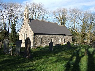
Haroldston St Issells is a former parish in Pembrokeshire, Wales, on the upper reaches of the Western Cleddau, 1 mile (1.6 km) southeast of Haverfordwest. Its area is 1,104 acres (447 ha); Haroldston church is co-located with Lower Haroldston and is a small attractive building. Haroldston ruins and Lower Haroldston can both be viewed from a circular walk along the banks of the Cleddau. Haroldston and other places in the parish are preserved as historic place names by the Royal Commission.

<span class="mw-page-title-main">Granston</span> Parish in Pembrokeshire, Wales

Granston is a hamlet and parish in Pembrokeshire, Wales. The parish was in the Hundred of Dewisland and includes the settlements of Llangloffan and Tregwynt, with Tregwynt woollen mill. Granston is in the community of Pencaer.

<span class="mw-page-title-main">Tufton, Pembrokeshire</span> Village in Pembrokeshire, Wales

Tufton is a crossroads hamlet in the parish of Henry's Moat in Pembrokeshire, Wales, on the B4329, a road between Eglwyswrw and Haverfordwest across the Preseli Hills. It is in the community of Puncheston.

<span class="mw-page-title-main">Brynberian</span> Village in Pembrokeshire, Wales

Brynberian is a small village in north Pembrokeshire, Wales, in the foothills of the Preseli Mountains in the Pembrokeshire Coast National Park. It is in the community of Eglwyswrw and the parish of Nevern, and is on the B4329 road between Crosswell and Tafarn y Bwlch. Afon Brynberian flows through the village under an ancient bridge and joins the River Nevern to the north.

<span class="mw-page-title-main">Morvil</span> Parish in Pembrokeshire, Wales

Morvil or Morfil is a remote upland parish on the southern slopes of the Preseli Mountains in north Pembrokeshire, Wales. Fishguard is 6 miles (10 km) to the northwest. The area was occupied in neolithic and Norman times, and in the past two centuries has been sparsely populated with no significant settlements developing. The parish church is dedicated to St John the Baptist.

<span class="mw-page-title-main">Llanstinan</span> Rural parish in Wales

Llanstinan is a rural parish in the community of Scleddau, north Pembrokeshire, Wales, 3 miles (4.8 km) south of Fishguard.

Hermon is a small rural village in the parish of Llanfyrnach and the community of Crymych, Pembrokeshire, Wales, about 1 mile (1.6 km) southeast of Crymych.

<span class="mw-page-title-main">Brynhenllan</span> Village in Pembrokeshire, Wales

Bryn-henllan, Bryn Henllan or Brynhenllan is a small settlement in the community of Dinas Cross, north Pembrokeshire, Wales, just north of the A487 road between Fishguard and Newport, on the road leading to Pwllgwaelod.

References

  1. "GENUKI: Ambleston Parish Map 50" . Retrieved 13 November 2018.
  2. "RCAHMW: List of historic place names" . Retrieved 13 November 2018.
  3. "Monthly Meetings". Y Goleuad (The Light). National Library of Wales. p. 12. Retrieved 20 July 2019.
  4. "Woodstock Ring (402164)". Coflein. RCAHMW . Retrieved 29 September 2021.
  5. Scourfield, R., Lloyd, T., Orbach, J. (2004). Pembrokeshire. Yale University Press. p. 497. ISBN   0300101783 . Retrieved 13 November 2018.{{cite book}}: CS1 maint: multiple names: authors list (link)
  6. "Pembrokeshire Historical Society". 28 November 2016. Retrieved 13 November 2018.
  7. 1 2 Fenton, Richard (1811). A Historical Tour through Pembrokeshire. Longman. pp.  356–7. Retrieved 13 November 2018. Woodstock Pembrokeshire.
  8. "Ambleston War Memorial" . Retrieved 13 November 2018.
  9. "Davies, Howel (c. 1716 - 1770), Methodist cleric". Dictionary of Welsh Biography . National Library of Wales . Retrieved 13 November 2018.
  10. "GENUKI: Ambleston" . Retrieved 13 November 2018.
  11. "British Listed Buildings: Woodstock Calvinistic Methodist Chapel" . Retrieved 13 November 2018.
  12. Cadw. "Woodstock Calvinistic Methodist Chapel (Grade II) (22755)". National Historic Assets of Wales . Retrieved 18 July 2019.
  13. "Dyfed FHS: Ambleston" . Retrieved 13 November 2018.