Related Research Articles

Worcestershire is a ceremonial county in the West Midlands of England. It is bordered by Shropshire, Staffordshire, and the West Midlands county to the north, Warwickshire to the east, Gloucestershire to the south, and Herefordshire to the west. The city of Worcester is the largest settlement and the county town.

Worcester is a cathedral city in Worcestershire, England, of which it is the county town. It is 30 mi (48 km) south-west of Birmingham, 27 mi (43 km) north of Gloucester and 23 mi (37 km) north-east of Hereford. The population was 103,872 in the 2021 census.

Droitwich Spa is a historic spa town in the Wychavon district in northern Worcestershire, England, on the River Salwarpe. It is located approximately 22 miles (35 km) south-west of Birmingham and 7 miles (11 km) north-east of Worcester.

Evesham is a market town and parish in the Wychavon district of Worcestershire, in the West Midlands region of England. It is located roughly equidistant between Worcester, Cheltenham and Stratford-upon-Avon. It lies within the Vale of Evesham, an area comprising the flood plain of the River Avon, which has been renowned for market gardening. The town centre, situated within a meander of the river, is subjected regularly to flooding. The 2007 floods were the most severe in recorded history.

Redditch is a town and borough in Worcestershire, England. It is located south of Birmingham, east of Bromsgrove, northwest of Alcester and northeast of Worcester. The borough had a population of 87,037 in 2021. In the 19th century, it became a centre for the needle and fishing tackle industry.

Selly Oak is an industrial and residential area in south-west Birmingham, England. The area gives its name to Selly Oak ward and includes the neighbourhoods of: Bournbrook, Selly Park, and Ten Acres. The adjoining wards of Edgbaston and Harborne are to the north of the Bourn Brook, which was the former county boundary, and to the south are Weoley, and Bournville. A district committee serves the four wards of Selly Oak, Billesley, Bournville and Brandwood. The same wards form the Birmingham Selly Oak constituency, represented since 2010 by Steve McCabe (Labour). Selly Oak is connected to Birmingham by the Pershore Road (A441) and the Bristol Road (A38). The Worcester and Birmingham Canal and the Birmingham Cross-City Railway Line run across the Local District Centre.

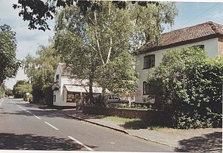
Abberley is a village and civil parish in north west Worcestershire, England.
Warwickshire County Record Office is the county record office for Warwickshire, England. Its purpose is to collect, preserve and make available archives relating to the history of the county and its people dating from the early 12th to the 21st century. It is located in the town of Warwick, and is owned and run by Warwickshire County Council.

The University of Worcester is a public research university, based in Worcester, England. Worcester is the only university based in the counties of Worcestershire and Herefordshire. With a history dating back to 1946, the university began awarding degrees in 1997 and was granted full university status in 2005.

Wychbold is a village in the Wychavon district of Worcestershire. The village is situated on the A38 between Droitwich Spa and Bromsgrove, and by Junction 5 of the M5 motorway.

Hanbury is a rural village in Worcestershire, England near Droitwich Spa and the M5 motorway. The population of Hanbury has remained around 1,000 since the early 19th century, and apart from farming and the popular Jinney Ring Craft Centre there is little economic activity, as the parish is lived in mainly by those who commute to the nearby towns of Bromsgrove, Redditch, Droitwich and Worcester, and the slightly more distant areas of Birmingham and the Black Country.

Oxfordshire History Centre is in the former Church of England parish church of St Luke, Cowley, Oxford, England. It collects, preserves and makes available the records of the historic county of Oxfordshire. It holds original records and printed material from the 12th to 21st century, which are available for all to see free of charge. It is owned and run by Oxfordshire County Council. It is recognised as a place of deposit by The National Archives.

St John's is a suburb of Worcester, England, lying west of the city centre and the River Severn. St. John's is referred to locally as the "Village in the City", which is partly due to being an independent township, before joining the city in 1837. There is still a sense of identity within the community.
Peopleton is a village and civil parish in the Wychavon district of Worcestershire, England. In 2001 the parish had a population of 640, with 245 households.
The Derbyshire Record Office, established in 1962, is the county record office for Derbyshire, England. It holds archives and local studies material for the County of Derbyshire and the City of Derby and Diocese of Derby. It is situated in Matlock. The Record Office contains more than four miles of original Derbyshire records.

Rochford consists of two hamlets, Lower and Upper Rochford. A civil parish in the Malvern Hills District near Tenbury Wells, in the county of Worcestershire, England, Rochford is 18 miles (29 km) NW of Worcester. The River Teme, which rises in Wales, flows past Lower Rochford and joins the River Severn in Worcester. The chapelry of Rochford was an exclave of Herefordshire, part of the hundred of Wolphy. It was transferred by the Counties Act 1844 to Worcestershire.

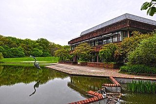
The Hive, is a large golden-coloured building in Worcester, England, which houses the fully integrated Worcestershire County Council, City of Worcester public library, the University of Worcester's academic library, Worcestershire Record Office, the county Archive and Worcestershire Archaeology Service.

Worcestershire Parkway is a split-level railway station where the Cotswold and Cross Country lines cross near Norton, Worcester, England. It opened on 23 February 2020.
County Hall is a municipal facility at Spetchley Road in Worcester, Worcestershire. It is the headquarters of Worcestershire County Council.

County Hall is a municipal building on New Road in Oxford, Oxfordshire, England. County Hall, which is the headquarters of Oxfordshire County Council, is a Grade II* listed building.
References
- ↑ Elizabeth Shepherd, Archives and archivists in 20th century England, Ashgate, 2009, pp. 97, 112