
The Aire and Calder Navigation is the canalised section of the Rivers Aire and Calder in West Yorkshire, England. The first improvements to the rivers above Knottingley were completed in 1704 when the Aire was made navigable to Leeds and the Calder to Wakefield, by the construction of 16 locks. Lock sizes were increased several times, as was the depth of water, to enable larger boats to use the system. The Aire below Haddlesey was bypassed by the opening of the Selby Canal in 1778. A canal from Knottingley to the new docks and new town at Goole provided a much shorter route to the River Ouse from 1826. The New Junction Canal was constructed in 1905, to link the system to the River Don Navigation, by then part of the Sheffield and South Yorkshire Navigation.
The Sheffield and South Yorkshire Navigation (S&SY) is a system of navigable inland waterways in South Yorkshire and Lincolnshire, England.

The River Etherow is a river in northern England, and a tributary of the River Goyt. Although now passing through South Yorkshire, Derbyshire and Greater Manchester, it historically formed the ancient county boundary between Cheshire and Derbyshire. The upper valley is known as Longdendale. The river has a watershed of approximately 30 square miles (78 km2), and the area an annual rainfall of 52.5 inches (1,330 mm).

The River Don is a river in South Yorkshire and the East Riding of Yorkshire, England. It rises in the Pennines, west of Dunford Bridge, and flows for 70 miles (113 km) eastwards, through the Don Valley, via Penistone, Sheffield, Rotherham, Mexborough, Conisbrough, Doncaster and Stainforth. It originally joined the Trent, but was re-engineered by Cornelius Vermuyden as the Dutch River in the 1620s, and now joins the River Ouse at Goole. Don Valley is a UK parliamentary constituency near the Doncaster stretch of the river.

Barnsley is a market town in South Yorkshire, England. As the main settlement of the Metropolitan Borough of Barnsley and the fourth largest settlement in South Yorkshire, the 2011 Census gave the town a population of 91,297 compared to the wider borough which had a population of 246,866. Historically in the West Riding of Yorkshire, it is located between the cities of Sheffield, Manchester, Wakefield, and Leeds. The larger towns of Rotherham, Huddersfield and Doncaster are nearby.

The Barnsley Canal is a canal that ran from Barnby Basin, through Barnsley, South Yorkshire, England to a junction with the Aire and Calder Navigation near Wakefield, West Yorkshire. It was built in the 1790s, to provide a transport link from coal reserves at Barnsley to a wider market. Both the Aire and Calder Navigation and the River Don Navigation took a keen interest in the project, the former buying many of the initial shares, and the latter constructing the Dearne and Dove Canal to link the canal to their waterway. Water supply issues meant that the Aire and Calder proposed pumping all of the water for the canal from the River Calder, using steam pumps, but a reservoir was built at Cold Hiendley instead, increasing the construction costs, but reducing the running costs. The canal as built was 14.5 miles (23.3 km) long and included 15 locks.
Worsbrough is an area about two miles south of Barnsley in the metropolitan borough of Barnsley, South Yorkshire, England. Before 1974, Worsbrough had its own urban district council in the West Riding of the historic county of Yorkshire and it is still counted as a separate place from Barnsley by the 2011 Census, but it is often treated as part of Barnsley as the two settlements run into one another.
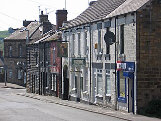
Elsecar is a village in the Metropolitan Borough of Barnsley in South Yorkshire, England. It is near the villages of Jump and Wentworth and 1.5 miles (2.4 km) south of the town of Hoyland, 6 miles (9.7 km) south of Barnsley and 8 miles (13 km) north-east of Sheffield. Elsecar falls within the Barnsley MBC Ward of Hoyland Milton. Like many villages in the area, it was for many years a colliery village until the widespread pit closures during the 1980s.

Birdwell is a village in the Metropolitan Borough of Barnsley in South Yorkshire, England and is located approximately 4.5 miles (7 km) south of Barnsley, 12.1 miles (19 km) north-east of Sheffield, and 20.0 miles (32 km) west of Doncaster. The village falls within the Rockingham Ward of the Barnsley Metropolitan Council. Neighbouring villages include Worsbrough, Tankersley and Hoyland Common.

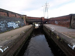
The Dearne and Dove Canal ran for almost ten miles through South Yorkshire, England from Swinton to Barnsley through nineteen locks, rising 127 feet (39 m). The canal also had two short branches, the Worsbrough branch and the Elsecar branch, both about two miles long with reservoirs at the head of each. The Elsecar branch also has another six locks. The only tunnel was bypassed by a cutting in 1840.

The Rochdale Canal is in Northern England, between Manchester and Sowerby Bridge, part of the connected system of the canals of Great Britain. Its name refers to the town of Rochdale through which it passes.

Netherton Reservoir - otherwise known as Lodge Farm Reservoir or locally known as The Rezza is a canal feeder reservoir in the Netherton district of Dudley, England. It opened in 1838, and is now used for watersports, as well as supplying water to the canal system.

Hollingworth Lake is a 130-acre (53 ha) reservoir at Smithy Bridge in Littleborough, Greater Manchester, England. It was originally built as the main water source for the Rochdale Canal, but developed as a tourist resort from the 1860s. Hotels were built around it, helped by the arrival of the railway in 1839, which brought day-trippers and weekend visitors from Manchester, Bradford and Leeds.

The River Frome, once also known as the Stroudwater, is a small river in Gloucestershire, England. It is to be distinguished from another River Frome in Gloucestershire, the Bristol Frome, and the nearby River Frome, Herefordshire. The river is approximately 25 miles (40 km) long.

The Sheffield & Tinsley Canal is a canal in the City of Sheffield, England. It runs 3.9 miles (6.3 km) from Tinsley, where it leaves the River Don, to the Sheffield Canal Basin in the city centre, passing through 11 locks. The maximum craft length that can navigate this lock system is 61 feet 6 inches (18.75 m) with a beam of 15 feet 6 inches (4.72 m).

The Stainforth and Keadby Canal is a navigable canal in South Yorkshire and Lincolnshire, England. It connects the River Don Navigation at Bramwith to the River Trent at Keadby, by way of Stainforth, Thorne and Ealand, near Crowle. It opened in 1802, passed into the control of the River Don Navigation in 1849, and within a year was controlled by the first of several railway companies. It became part of the Sheffield and South Yorkshire Navigation, an attempt to remove several canals from railway control, in 1895. There were plans to upgrade it to take larger barges and to improve the port facilities at Keadby, but the completion of the New Junction Canal in 1905 made this unnecessary, as Goole could easily be reached and was already a thriving port.

Grosvenor Canal was a canal in the Pimlico area of London, opened in 1824. It was progressively shortened, as first the railways to Victoria Station and then the Ebury Bridge housing estate were built over it. It remained in use until 1995, enabling barges to be loaded with refuse for removal from the city, making it the last canal in London to operate commercially. A small part of it remains among the Grosvenor Waterside development.

Beverley Beck is a short canal in the East Riding of Yorkshire, England. The beck runs from Grovehill Lock on the River Hull at Beverley west for about 0.8 miles (1.3 km) into the town of Beverley. Until 1802, the beck was tidal, but the Beverley and Barmston Drain needed to pass under it, and the lock was constructed to maintain water levels over its tunnel. In 1898, a steam engine was installed, which could be used to top up the water levels in the beck by pumping water from the River Hull. A multimillion-pound refurbishment of the area concluded in 2007, with the refurbishment of the lock gates and pumping engine.

The River Don Navigation was the result of early efforts to make the River Don in South Yorkshire, England, navigable between Fishlake and Sheffield. The Dutch engineer Cornelius Vermuyden had re-routed the mouth of the river in 1626, to improve drainage, and the new works included provision for navigation, but the scheme did not solve the problem of flooding, and the Dutch River was cut in 1635 to link the new channel to Goole. The first Act of Parliament to improve navigation on the river was obtained in 1726, by a group of Cutlers based in Sheffield; the Corporation of Doncaster obtained an Act in the following year for improvements to the lower river. Locks and lock cuts were built, and, by 1751, the river was navigable to Tinsley.

The River Dove is a river that extends through the Low Valley in Barnsley, England. It flows from Worsbrough Reservoir to its confluence with the River Dearne.
