Worthing, Norfolk

Last updated

Worthing
Worthing-g1.jpg
Worthing St. Margaret
Norfolk UK location map.svg
Red pog.svg
Worthing
Location within Norfolk
Civil parish
District
Shire county
Region
Country England
Sovereign state United Kingdom
List of places
UK
England
Norfolk
52°44′N0°58′E / 52.74°N 00.96°E / 52.74; 00.96

Worthing is a small village and former civil parish, now in the parish of Hoe and Worthing, in the Breckland district, in the county of Norfolk, England. The civil parish of Worthing is now merged with that of the neighbouring village of Hoe, though the ecclesiastical parishes are still separate (see below). In 1931 the parish had a population of 120. [1] On 1 April 1935 Worthing was abolished and merged with Hoe, [2] the renamed parish is now called "Hoe and Worthing".

Contents

Parish church

Its church, dedicated to St. Margaret, is one of 124 extant round-tower churches in Norfolk. Once a larger building, the upper section of the round tower was removed in the 18th-century, and the chancel was demolished at a date between 1721 and 1820. What remains is the original nave, and the lower section of the tower, together with the small porch. The church features in Pevsner. [3]

The parish of Worthing is now part of the Heart of Norfolk Benefice, a group of thirteen parishes and churches which operate collectively, with a shared parish priest. The benefice is part of the Diocese of Norwich. [4] The church is open daily, thanks to an automated keyless entry system installed by the PCC. [5]

Railway

The Mid-Norfolk Railway operates a heritage railway service to a location near to the village, just a few yards to the north of Worthing level crossing. Regular services currently stop at Dereham railway station, but special sightseeing trains continued northwards to Worthing on 19 May 2018. [6] Although no station is available, Worthing is indicated on the Mid-Norfolk Railway's timetable as the northerly limit of operations. [7]

Facilities

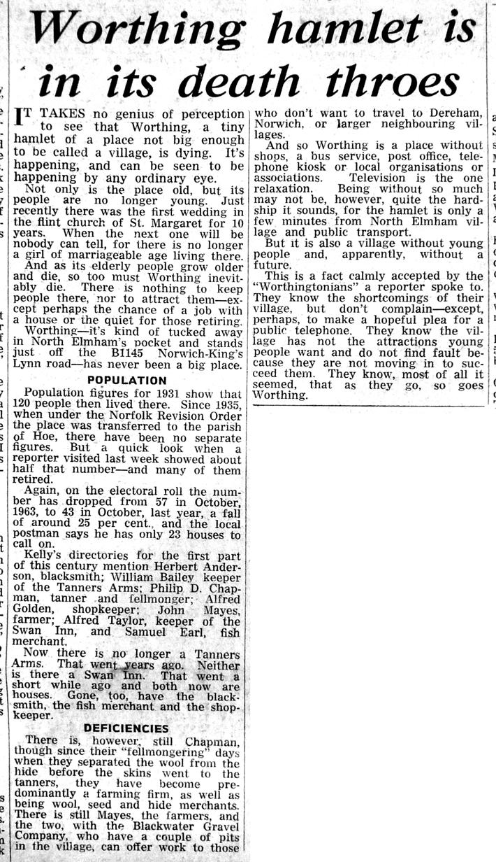
Apart from the church and the railway, local community facilities have closed. Worthing's two pubs, The Tanners Arms and The Swan Inn, had both closed by the mid 1960s, and are now private houses. The village store, blacksmiths, and fishmongers have all closed, as have employers including the gravel pits and the tannery which provided much employment during the twentieth century. In August 1966 the local Dereham Times newspaper ran an illustrated article under the title Worthing hamlet is in its death throes, reporting Worthing's population as 120 in 1931, 57 in 1963, and just 43 in 1965. The local postman was quoted as stating that he delivered post to only 23 occupied dwellings in Worthing. [8]

Related Research Articles

<span class="mw-page-title-main">Dereham</span> Human settlement in England

Dereham, formerly known as East Dereham, is a town and civil parish in the Breckland District of the English county of Norfolk. It is situated on the A47 road, about 15 miles (25 km) west of the city of Norwich and 25 miles (40 km) east of King's Lynn.

<span class="mw-page-title-main">Mid-Norfolk Railway</span> Heritage railway in Norfolk, England

The Mid-Norfolk Railway (MNR) is a 17+12 miles (28.2 km) preserved standard gauge heritage railway, one of the longest in Great Britain. Preservation efforts began in 1974, but the line re-opened to passengers only in the mid-1990s as part of the "new generation" of heritage railways. The MNR owns and operates most of the former Wymondham-Fakenham branch line of the Norfolk Railway. The branch opened in 1847, was closed to passengers in stages from 1964 to 1969 as part of the Beeching cuts, and was finally fully closed to goods traffic in 1989.

<span class="mw-page-title-main">West Dereham</span> Human settlement in England

West Dereham is a village and civil parish in the English county of Norfolk. It covers an area of 13.51 km2 (5.22 sq mi) and had a population of 440 in 176 households as of the 2001 census, the population increasing to 450 at the 2011 Census. For the purposes of local government, it falls within the district of King's Lynn and West Norfolk.

<span class="mw-page-title-main">Gateley</span> Human settlement in England

Gateley is a village and civil parish in the Breckland district of Norfolk, England.

<span class="mw-page-title-main">Great Ryburgh</span> Human settlement in England

Great Ryburgh is a village and former civil parish, now in the parish of Ryburgh, in the North Norfolk district, in the county of Norfolk, England. In 1961 the parish had a population of 484. On 1 April 1987 the parish was abolished and merged with Little Ryburgh to form "Ryburgh".

<span class="mw-page-title-main">Yaxham</span> Human settlement in England

Yaxham is a village and civil parish in centre of the English county of Norfolk. The parish includes the village of Yaxham, together with the neighbouring community of Clint Green. Together, they lie some 2 miles (3.2 km) south of Dereham and 20 miles (32 km) west of Norwich.

<span class="mw-page-title-main">North Elmham railway station</span> Railway station in Norfolk, England

North Elmham railway station is a railway station in the village of North Elmham in the English county of Norfolk. The station was part of the Wymondham to Wells Branch, and is part of a section of the line being restored by the Mid-Norfolk Railway from Dereham to County School railway station.

<span class="mw-page-title-main">East Lexham</span> Human settlement in England

East Lexham is a village and former civil parish, now in the parish of Lexham, in the Breckland district, in the English county of Norfolk. It is 7.7 miles (12.4 km) north of the town of Swaffham, 30.1 miles (48.4 km) west north west of Norwich and 106 miles (171 km) north east of London. In 1931 the parish had a population of 160.

<span class="mw-page-title-main">West Lexham</span> Human settlement in England

West Lexham is a village and former civil parish, now in the parish of Lexham, in the Breckland district, in the county of Norfolk, England. It is 5.9 miles (9.5 km) north of the town of Swaffham, 30.6 miles (49.2 km) west north west of Norwich and 105 miles (169 km) north east of London. In 1931 the parish had a population of 101. On 1 April 1935 the parish was abolished to form Lexham.

<span class="mw-page-title-main">Tuttington</span> Human settlement in England

Tuttington is a village and former civil parish, now in the parish of Burgh and Tuttington, in the Broadland district, in the county of Norfolk, England. The village is 11.1 miles south of Cromer, 15 miles north of Norwich and 129 miles north-east of London. The village lies 3 miles east of the nearby town of Aylsham.

<span class="mw-page-title-main">Great Fransham</span> Human settlement in England

Great Fransham is a village and former civil parish in the Breckland district, in the county of Norfolk, England, roughly about an equal distance between Swaffham and Dereham. There is also a Little Fransham; the two villages, both now part of the parish of Fransham, were once served by Fransham railway station. In 1931 the parish had a population of 222. On 1 April 1935 the parish was abolished and merged to form Fransham.

<span class="mw-page-title-main">Thuxton</span> Human settlement in England

Thuxton is a small village and former civil parish, now in the parish of Garvestone, Reymerston and Thuxton, in the Breckland district, in the county of Norfolk, England. It is 6 miles north west of Wymondham and 5 miles south east of Dereham. In 1931 the parish had a population of 83. The village retains a church, St Paul's, which has a monthly service and special events. On the 1st of April 1935 the parish was merged with Thuxton to form "Garveston", later the parish was renamed to "Garvestone, Reymerston and Thuxton".

<span class="mw-page-title-main">Garvestone</span> Human settlement in England

Garvestone is a village and former civil parish, now in the parish of Garvestone, Reymerston and Thuxton, in the Breckland district, in the county of Norfolk, England. It is located 3.8 miles (6.1 km) south-east of Dereham and 7 miles (11 km) north-west of Wymondham, on the upper reaches of the River Yare.

<span class="mw-page-title-main">Great Ellingham</span> Human settlement in England

Great Ellingham is a village and civil parish in the Breckland District of Norfolk. The village lies 2.5 miles north-west of Attleborough, 2 miles south-east of its sister village of Little Ellingham and 12 miles by road south from Dereham. The civil parish also includes the hamlets of Bow Street and Stalland Common, and covers an area of 1,114 hectares with a population of 1108 at the 2001 census, though the district's 2007 estimate suggests that this may have risen to 1165, then decreasing to a measured population of 1,132 in 470 households at the 2011 Census.

<span class="mw-page-title-main">Hoe, Norfolk</span> Human settlement in England

Hoe is a village and former civil parish, now in the parish of Hoe and Worthing, situated in Norfolk. The parish of Hoe and Worthing covers an area of 925 hectares, with an estimated population of 219 at the 2001 census, increasing to 241 at the 2011 Census. For local government purposes it falls within the Elmham and Mattishall Division of Norfolk County Council and the Lincoln Ward of Breckland District Council.

<span class="mw-page-title-main">Kimberley, Norfolk</span> Human settlement in England

Kimberley is a village and civil parish in the South Norfolk district, in the county of Norfolk, England, situated about 3 miles (4.8 km) north-west of Wymondham, around the crossroads of the B1108 and B1135. The parish has an area of 9.33 km2 (3.60 sq mi) and had a total population of 121 in 52 households as of the 2001 census. The parish absorbed the parish of Carleton Forehoe on the 1 April 1935.

<span class="mw-page-title-main">Finningham</span> Human settlement in England

Finningham is a village and civil parish in the Mid Suffolk district of Suffolk in the East of England, located approximately 7.5 miles north of Stowmarket and 16 miles from the county town of Ipswich. In 2011 its population was 480.

<span class="mw-page-title-main">Ashby, Suffolk</span> Human settlement in England

Ashby is a former civil parish, now in the parish of Somerleyton, Ashby and Herringfleet, in the East Suffolk district, in the north of the English county of Suffolk. It is 5+12 miles (8.9 km) north-west of Lowestoft.

<span class="mw-page-title-main">Leziate</span> Human settlement in England

Leziate is a village and civil parish in the English county of Norfolk. The village is 44 miles (71 km) west of Norwich, 5.7 miles (9.2 km) east of King's Lynn and 106 miles (171 km) north-north-east of London. The Village is located a small distance south of the B1145 a route which runs between King's Lynn and Mundesley. The nearest railway station is at King's Lynn for the Fen Line which runs between King's Lynn and Cambridge. The nearest airport is Norwich International Airport. The parish of Leziate in the 2001 census, has a population of 581, including Ashwicken and increasing to 592 at the 2011 census.

<span class="mw-page-title-main">Reymerston</span> Human settlement in England

Reymerston is a village and former civil parish, now in the parish of Garvestone, Reymerston and Thuxton, in the Breckland district, in the county of Norfolk, England, six miles north west of Wymondham, six miles south east of Dereham, and a half mile south west of Thuxton. In 1931 the parish had a population of 220. The village retains a church, St. Peter, which has a weekly service and special events. One of the village's residents was Wing Commander Ken Wallis, who lived at Reymerston Hall. He built autogyros and constructed "Little Nellie" for the James Bond film You Only Live Twice. On the 1st of April 1935 the parish was merged with Thuxton to form "Garveston"; later the parish was renamed to "Garvestone, Reymerston and Thuxton".

References

  1. "Population statistics Worthing CP/AP through time". A Vision of Britain through Time . Retrieved 22 May 2022.
  2. "Relationships and changes Worthing CP/AP through time". A Vision of Britain through Time. Retrieved 22 May 2022.
  3. "St Margaret, Worthing". Norfolk Churches. Retrieved 7 May 2018.
  4. "Worthing: St Margaret". The Church of England (ACNY). Retrieved 7 May 2018.
  5. "About St Margaret, Worthing". Heart of Norfolk Churches. Retrieved 7 May 2018.
  6. "Return to Worthing Weekend - 19th & 20th May". Mid-Norfolk Railway. Retrieved 7 May 2018. We will be officially re-opening the line to Worthing on 19th & 20th May.
  7. "2018 Timetable". Mid-Norfolk Railway 2018 Timetable & Guide. Dereham: Mid-Norfolk Railway. 2018.
  8. "Worthing hamlet is in its death throes". Dereham Times / Hoe and Worthing Villages. Retrieved 7 May 2018.