
The Wrynose Pass is a mountain pass in the Lake District National Park in Cumbria, England between the Duddon Valley and Little Langdale.
The Wrynose Pass is a mountain pass in the Lake District National Park in Cumbria, England between the Duddon Valley and Little Langdale.
The unusual name of the pass is taken from that of the adjacent Wrynose hill, also called Wrynose Fell. The name was recorded in 12th-century documents as "Wrenhalse" and in the 16th century as "Wrenosse Hill". It is thought, based on a suggestion by Eilert Ekwall, to mean "stallion's ridge", being formed on the Old Norse words (v)reini ("stallion", probably here used as a byname for an individual), and hala. [1] It is one of a number of place names of Scandinavian origin in the area. Although most academic sources characterise "Vreini" in this context as a personal name, it has also been explained as suggesting "the horse power needed to climb it". [2] Other suggested origins are from Old Norse ravn hals, "pass of the raven", [3] and wreye nes, the "twisted headland". [4] Over the years, the name has been altered to the form "Wrynose" through folk etymology, though it is still locally pronounced "Wreynuss", much like its older form. [5]
There is a single-track motor road over the pass with gradients up to 1 in 4. The pass reaches an altitude of 393m or 1,281 feet. The road continues over Hardknott Pass, whose 1 in 3 gradient is the steepest road in England, and goes on to Eskdale. The modern road overlays a Roman road for some of the route, with the Roman track visible alongside in other stretches. [6]
The pass separates the Furness Fells from the Bowfell-Crinkle Crags massif.
At the top of the Wrynose Pass is the Three Shire Stone, marking the meeting point of the historic counties of Cumberland, Lancashire and Westmorland. Prior to the early 19th century, three "county stones" existed in the same spot. [7]

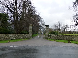
At the bottom of Wrynose is Fell Foot Farm, a 17th-century, Grade II listed, National Trust property.

Cumbria is a ceremonial and non-metropolitan county in North West England, bordering Scotland. The county and Cumbria County Council, its local government, came into existence in 1974 after the passage of the Local Government Act 1972. Cumbria's county town is Carlisle, in the north of the county. The only other major urban area is Barrow-in-Furness on the south-western tip of the county.

The Lake District, also known as the Lakes or Lakeland, is a mountainous region in North West England. A popular holiday destination, it is famous for its lakes, forests and mountains, and its associations with William Wordsworth and other Lake Poets and also with Beatrix Potter and John Ruskin. The Lake District National Park was established in 1951 and covers an area of 2,362 square kilometres (912 sq mi). It was designated a UNESCO World Heritage Site in 2017.
Cumberland is a historic county in North West England that had an administrative function from the 12th century until 1974. It is bordered by the historic counties of Northumberland to the north-east, County Durham to the east, Westmorland to the south-east, Lancashire to the south, and the Scottish counties of Dumfriesshire and Roxburghshire to the north. It formed an administrative county from 1889 to 1974 and now forms part of Cumbria. In April 2023, local government in Cumbria will be reorganised into two unitary authorities; one of these is to be named Cumberland and would include most of the historic county, with the exception of Penrith and the surrounding area.

Coniston Water in the English county of Cumbria is the third-largest lake in the Lake District by volume, and the fifth-largest by area. It is five miles long by half a mile wide, has a maximum depth of 184 feet (56 m), and covers an area of 1.89 square miles (4.9 km2). The lake has an elevation of 143 feet (44 m) above sea level. It drains to the sea via the River Crake.

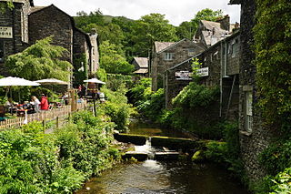
Grasmere is a village and tourist destination in Cumbria, England, in the centre of the Lake District, named after its adjacent lake. It has links with the Lake Poets: William and Dorothy Wordsworth lived in Grasmere for 14 years and called it "the loveliest spot that man hath ever found." Grasmere lies within the historic county of Westmorland. In 1961, the civil parish had a population of 1,029. That of the Ambleside and Grasmere ward was 4,475 in the 2011 census and estimated at 4,592 in 2019.
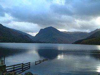
Buttermere is a lake in the Lake District in North West England. The adjacent village of Buttermere takes its name from the lake. Historically in Cumberland, the lake is now within the county of Cumbria. Owned by the National Trust, it forms part of its Buttermere and Ennerdale property.

Furness is a peninsula and region of Cumbria in northwestern England. Together with the Cartmel Peninsula it forms North Lonsdale, historically an exclave of Lancashire.

The Old Man of Coniston is a fell in the Furness Fells in the Cumbria, English Lake District and is the highest point of the historic county of Lancashire. It is at least 2,632.62 feet (802.42 m) high, and lies to the west of the village of Coniston and the lake, Coniston Water. The fell is sometimes known by the alternative name of Coniston Old Man, or simply The Old Man. The mountain is popular with tourists and fell-walkers with a number of well-marked paths to the summit. The mountain has also seen extensive copper and slate mining activity for eight hundred years, and the remains of abandoned mines and spoil tips are a significant feature of the north-east slopes.

Hardknott Pass is a hill pass between Eskdale and the Duddon Valley in the Lake District National Park, Cumbria, England. The tarmac-surfaced road, which is the most direct route from the central Lake District to West Cumbria, shares the title of steepest road in England with Rosedale Chimney Bank in North Yorkshire. It has a maximum gradient of 1 in 3.

The Three Shire Stone is a boundary stone that marks the location where the historic English counties of Lancashire, Cumberland and Westmorland meet. The point is in the English Lake District at the summit of Wrynose Pass; latitude 54°25' North, longitude 3°7' West, elevation 1289 feet above sea level.

The Brathay is a river of north-west England. Its name comes from Old Norse and means broad river. It rises at a point 1289 feet above sea level near the Three Shire Stone at the highest point of Wrynose Pass in the Lake District. Its catchment area includes the northern flanks of Wetherlam, Great Carrs and others of the Furness Fells, as well as a substantial area of the Langdale Fells.

The Furness Fells are a multitude of hills and mountains in the Furness region of Cumbria, England. Historically part of Lancashire, the Furness Fells or High Furness is the name given to the upland part of Furness, that is, that part of Furness lying north of the line between Ulverston and Ireleth. The hills lie largely within the English Lake District.

The Barony of Kendal is a subdivision of the English historic county of Westmorland. It is one of two ancient baronies that make up the county, the other being the Barony of Westmorland. In 1974, the entire county became part of the modern county of Cumbria and ceased to have an administrative function. At the same time, Kendal borough along with some other rural and urban districts in Westmorland was merged with the neighbouring parts of Lancashire, Furness and Cartmel, and also the Sedbergh Rural District of the West Riding of Yorkshire into the new South Lakeland district of the new county.

The Cumberland dialect is a local Northern English dialect in decline, spoken in Cumberland, Westmorland and Lancashire North of the Sands, not to be confused with the area's extinct Celtic language, Cumbric. Some parts of Cumbria have a more North-East English sound to them. Whilst clearly spoken with a Northern English accent, it shares much vocabulary with Scots. A Cumbrian Dictionary of Dialect, Tradition and Folklore by William Rollinson exists, as well as a more contemporary and lighthearted Cumbrian Dictionary and Phrase Book.

Waberthwaite is a small, former rural civil parish on the south bank of the estuary of the River Esk, in Copeland, Cumbria, England. Since 1934 it has been part of the combined parish of Waberthwaite and Corney, which covers 10 square miles and has a population of 246. It is located opposite Muncaster Castle and the village of Ravenglass which lie on the north bank of the Esk. It is well known for its Cumberland sausages, and lists among its other assets a granite quarry that is a Site of Special Scientific Interest (SSSI); the Esk estuary, which forms part of the Drigg Coast Special Area of Conservation (SAC) - a designation for areas of European importance; the 800-year-old St. John's Church, and the remains of two Anglian/Norse crosses of an earlier period. Archeological finds within 3 kilometres of Waberthwaite indicate that the area has been continuously inhabited since Mesolithic times.

Dunmail Raise is the name of a large cairn in the English Lake District, which may have been an old boundary marker. It has given its name to the mountain pass of Dunmail Raise, on which it stands. This mountain pass forms part of the only low-level route through the mountains between the northern and southern sides of the Lake District. According to local tradition, the cairn marked the burial of a king named Dunmail who was slain by Saxons. The place name itself may well be derived from the name of the historical Dyfnwal ab Owain, King of Strathclyde.
Cumbrian toponymy refers to the study of place names in Cumbria, a county in North West England, and as a result of the spread of the ancient Cumbric language, further parts of northern England and the Southern Uplands of Scotland.
Walna Scar is a hill in the English Lake District, lying just south of a pass of the same name in the Coniston Hills. Its summit at 2,035 feet (620 m) is only slightly higher than the pass.
Over Burrow Roman Fort is the modern name given to a former Roman fort at Over Burrow, Lancashire in North West England. Today it is the site of the 18th-century country house Burrow Hall. The first castra is thought to have been founded in the first century AD within the Roman province of Britannia.
Stock Ghyll, also known as Stock Gill, Stock Gill Beck and Stock Beck, is a stream in South Lakeland, in the ceremonial county of Cumbria and the historic county of Westmorland. It flows about four miles from Red Screes through the town of Ambleside to the River Rothay. Its course includes two long-popular tourist attractions, Stockghyll Force and Bridge House. Stock Ghyll has been painted by J. M. W. Turner, John Ruskin, Kurt Schwitters, and many others. Its name derives from Old English stocc, 'tree-trunk', and Old Norse gil, 'a deep glen'.