
Mackinac Island is an island and resort area, covering 4.35 square miles (11.3 km2) in land area, in the U.S. state of Michigan. The name of the island in Odawa is Michilimackinac and "Mitchimakinak" in Ojibwemowin meaning "Great Turtle". It is located in Lake Huron, at the eastern end of the Straits of Mackinac, between the state's Upper and Lower Peninsulas. The island was long home to an Odawa settlement and previous indigenous cultures before European colonization began in the 17th century. It was a strategic center of the fur trade around the Great Lakes. Based on a former trading post, Fort Mackinac was constructed on the island by the British during the American Revolutionary War. It was the site of two battles during the War of 1812 before the northern border was settled and the US gained this island in its territory.

Fort Michilimackinac was an 18th-century French, and later British, fort and trading post at the Straits of Mackinac; it was built on the northern tip of the lower peninsula of the present-day state of Michigan in the United States. Built around 1715, and abandoned in 1783, it was located along the Straits, which connect Lake Huron and Lake Michigan of the Great Lakes of North America.

The Grand Hotel is a historic hotel and coastal resort on Mackinac Island, Michigan, a small island located at the eastern end of the Straits of Mackinac within Lake Huron between the state's Upper and Lower peninsulas. Constructed in the late 19th century, the facility advertises itself as having the world's largest porch. The Grand Hotel is well known for a number of notable visitors, including five U.S. presidents, inventor Thomas Edison, and author Mark Twain.
This is a list of properties on the National Register of Historic Places in the U.S. state of Michigan.
This National Park Service list is complete through NPS recent listings posted March 10, 2023.

This is a list of the National Register of Historic Places listings in Mackinac County, Michigan.

Historic Mill Creek Discovery Park, formerly known as Historic Mill Creek State Park is a state park, nature preserve, and historic site in the United States state of Michigan. It is run by Mackinac State Historic Parks, the operating arm of the Mackinac Island State Park. 625 acres (2.5 km²) in size, the park is located 5 miles (8 km) southeast of Mackinaw City, Michigan on U.S. Highway 23.

The Mission Church is a historic Congregational church located at the corner of Huron and Tuscott Streets on Mackinac Island, Michigan, United States. Built in 1829, it was the oldest surviving church in the state of Michigan. In 1971, the Mission Church was listed on the National Register of Historic Places.

For the lighthouse of the same name in the St. Mary's River, see Round Island Light

The Lamoka site, or simply Lamoka, is an archaeological site near Tyrone, in Schuyler County, New York that was named a National Historic Landmark in 1961. According to the National Park Service, "This site provided the first clear evidence of an Archaic hunting and gathering culture in the Northeastern United States ".

The St. Ignace Mission is located in a municipal park known as Marquette Mission Park. It was the site of a mission established by Jesuit priest, Father Jacques Marquette, and the site of his grave in 1677. A second mission was established at a different site in 1837, and the chapel was moved here in 1954. The second mission chapel is the oldest Catholic church in Michigan and Wisconsin. The St. Ignace Mission was designated a Michigan State Historic Site in 1956, and was declared a U.S. National Historic Landmarks in 1960, one of the earliest sites recognized. The mission chapel serves as the Museum of Ojibwa Culture.
The Spring Creek site (20MU3) is a significant archaeological site in the U.S. state of Michigan. Located in Muskegon County in the western portion of the Lower Peninsula, it is the type site for a certain type of Late Woodland period pottery produced by the Ottawa tribe.

The Summer Island site, designated 20DE4, is an archaeological site located on the northwest side of Summer Island, in Delta County, Michigan. It is classified as a stratified, multi-component site with Middle Woodland, Upper Mississippian and Early Historic/Protohistoric occupations. It was listed on the National Register of Historic Places in 1971.
The Gros Cap Archaeological District is a set of three archaeological sites located in Moran Township, Michigan, USA, designated 20MK6, 20MK7 and 20MK111. It was listed on the National Register of Historic Places in 1982. The three sites cover 13.5 acres (5.5 ha) and include a village site and portions of the Gros Cap Cemetery.

The Gros Cap Cemetery, once known as the Western Cemetery, is a cemetery located southeast of Gros Cap, Michigan on US 2. It is one of the oldest cemeteries in the United States to be continuously used, and a portion is contained in the Gros Cap Archaeological District. It was designated a Michigan State Historic Site in 1970 and listed on the National Register of Historic Places in 1971.
The Lasanen Site, designated 20MA21, is an archaeological site located in St. Ignace, Michigan. It was listed on the National Register of Historic Places in 1971.

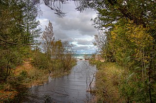
The Juntunen site, also known as 20MK1, is a stratified prehistoric Late Woodland fishing village located on the western tip of Bois Blanc Island. It was listed on the National Register of Historic Places in 1978.
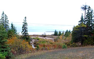
The Scott Point site, also known as 20MK22 or (erroneously) as the Point Patterson site, is an archaeological site located near the shore of Lake Michigan near Scott Point, south of Gould City, Michigan and west of Point Patterson. It was listed on the National Register of Historic Places in 1976.
The O'Neill Site, also designated 20CX18, is an archaeological site located about 5 km south Charlevoix, Michigan. It was listed on the National Register of Historic Places in 1971.
Wycamp Lake is a shallow lake in Emmet County in the U.S. state of Michigan. 709 acres (287 ha) in size, it is located approximately 3 miles (4.8 km) northeast of Cross Village, Michigan. It is located within Mackinaw State Forest and is served by local unimproved roads and by the North Country Trail.

