Wye Valley, Derbyshire

Last updated

Wye Valley, Derbyshire
Monsal Head - View of the Viaduct and River Wye - geograph.org.uk - 756604.jpg
Monsal Head Viaduct and River Wye
Length15 miles (24 km)West-East
Width100 to 500 metres (330 to 1,640 ft)
Depth100 metres (330 ft)
Geography
Location Derbyshire, England
Coordinates 53°14′56″N1°51′35″W / 53.2488°N 1.8598°W / 53.2488; -1.8598 Coordinates: 53°14′56″N1°51′35″W / 53.2488°N 1.8598°W / 53.2488; -1.8598
Rivers River Wye
Wye Valley, Derbyshire
BSicon numN090.svg
BSicon WCONTfa.svg
BSicon lCSTRa@f.svg
BSicon LWASSER.svg
Axe Edge
BSicon wCSTR.svg
Buxton
BSicon wCSTR.svg
Mill Dale
BSicon wCSTR.svg
Ashwood Dale
BSicon lCSTRe-Rq.svg
BSicon lCKRZ.svg
BSicon WASSER.svg
BSicon lwCSTRq.svg
BSicon lCSTReq.svg
Cow Dale │ Cunning Dale
BSicon wCSTR.svg
Wye Dale
BSicon lCSTRe-Rq.svg
BSicon wCSTRq.svg
BSicon lCKRZ.svg
BSicon WABZg+r.svg
BSicon lwCSTRq.svg
BSicon lCSTReq.svg
Deep Dale │ Woo Dale
BSicon lCSTRe-Rq.svg
BSicon lCKRZ.svg
BSicon WASSER.svg
BSicon lwCSTRq.svg
BSicon lCSTReq.svg
Great Rocks Dale
BSicon wCSTR.svg
Chee Dale
BSicon lwCSTR(r).svg
BSicon lCJCTfq(l).svg
BSicon WASSER.svg
BSicon lCSTReq.svg
Flag Dale
BSicon lCSTRe-Rq.svg
BSicon WASSER+r.svg
BSicon lCKRZ.svg
BSicon WABZg+l.svg
BSicon wCSTRq.svg
BSicon lCSTReq.svg
Blackwell Dale │ Monk's Dale
BSicon wCSTR.svg
Miller's Dale
BSicon lwCSTR(r).svg
BSicon lCJCTfq(l).svg
BSicon WABZg+l.svg
BSicon wCSTRq.svg
BSicon lCSTReq.svg
Tideswell Dale
BSicon lwCSTR(r).svg
BSicon lCJCTfq(l).svg
BSicon WABZg+l.svg
BSicon wCSTRq.svg
BSicon lCSTReq.svg
Cressbrook Dale
BSicon wCSTR.svg
Upperdale
BSicon lwCSTR(r).svg
BSicon lCJCTfq(l).svg
BSicon WASSER.svg
BSicon lCSTReq.svg
Hay Dale
BSicon wCSTR.svg
Monsal Dale
BSicon lCSTRe-Rq.svg
BSicon lwCSTRq.svg
BSicon lCJCTgq(r).svg
BSicon lwCSTR(l).svg
BSicon WASSER.svg
Taddington Dale
BSicon lCSTRe-Rq.svg
BSicon lwCSTRq.svg
BSicon lCJCTgq(r).svg
BSicon lwCSTR(l).svg
BSicon WASSER.svg
Deep Dale
BSicon lCSTRe-Rq.svg
BSicon lwCSTRq.svg
BSicon lCJCTgq(r).svg
BSicon lwCSTR(l).svg
BSicon WASSER.svg
Kirk Dale
at Ashford-in-the-Water
BSicon lCJCTg(g).svg
BSicon WASSER.svg
Bakewell
BSicon lCSTRe-Rq.svg
BSicon wCSTRq.svg
BSicon lCJCTgq(r).svg
BSicon WASSERq.svg
BSicon WABZg+r.svg
Lathkill Dale
BSicon WCONTf.svg
River Derwent at Rowsley

The Wye Valley is the limestone valley of the River Wye in the White Peak of Derbyshire, England. The source of the River Wye is west of Buxton on Axe Edge Moor. One main channel runs underground through Poole's Cavern. The river flows though Buxton Pavilion Gardens and then along a culvert under the town centre. After leaving the flat area of central Buxton, the Wye Valley becomes distinct as a gorge running east for 10 miles (16 km) before the valley broadens at Ashford-in-the Water. [1]

Contents

The A6 road from Buxton to Bakewell follows the Wye Valley for most of its path. The Manchester, Buxton, Matlock and Midland Junction Railway used to run through the valley. It was built to link Manchester through the Peak District to London and operated from the 1860s to 1968. [2]

Geology

Limestone crags beside the River Wye River Wye above Cressbrook Mill - geograph.org.uk - 150325.jpg
Limestone crags beside the River Wye

The White Peak area of the Peak District is named after the limestone plateau landscape of the 'Derbyshire Dome' anticline. The plateau is generally between 200 and 300 m (660 and 980 ft) above sea level. The Carboniferous limestone rocks of all the dales in the White Peak were formed 350 million years ago from the shells and sediments of a tropical sea. These deposits were compressed into rocks which over time were uplifted and folded into a dome. Erosion of the younger sandstones exposed the limestone strata below. The landscape of dales was then sculpted by the melt water from the last Ice Age 20,000 years ago. [3] [4]

Dales

Beyond Buxton the Wye Valley is known as a series of dales, which are gorges with numerous side valley gorges.

Ashwood Dale

Cowdale quarry lime kilns in Ashwood Dale Lime Kilns at Cowdale Quarry.jpg
Cowdale quarry lime kilns in Ashwood Dale

After leaving Ashwood Park (in Mill Dale) in Buxton, the river enters the steep-sided Ashwood Dale. Here Joseph Mallard William Turner sketched Lovers' Leap and its waterfall in about 1831. [5] The story of Lovers' Leap is that an eloping couple managed to leap across the chasm on horseback on their way to get married at Peak Forest church, evading their pursuing parents. [6] The narrow dry gorge of Cunning Dale joins from the north. The short steep Cow Dale and Kidtor Dale are next to each other on the opposite side to Cunning Dale. The remains of Cowdale quarry's 19th-century buildings and lime kilns are high up on the south slope. The site is a Scheduled Monument. [7]

Wye Dale

View of Deep Dale from Thirst House cave View of Deep Dale from Thirst House cave - geograph.org.uk - 723850.jpg
View of Deep Dale from Thirst House cave

The dry valley of Woo Dale joins Wye Dale from the north. 'Woo Dale Limestone' is quarried at Tarmac's Tunstead Quarry (the largest limestone quarry in the UK) between Woo Dale and Great Rocks Dale. Topley Pike limestone quarry is on the south side of the Wye Valley opposite Woo Dale and close to the hamlet of King Sterndale. Deep Dale also joins the main valley from the south. Thirst House Cave in Deep Dale is 58 m (190 ft) long and in the late 19th-century a bear's skull and Roman artefacts were discovered there. [8] The Peak District Boundary Walk route comes down Deep Dale and along Wye Dale before heading north at Chee Dale. [9]

Chee Dale

Stepping stones in Chee Dale Stepping Stones, Chee Dale - geograph.org.uk - 1081589.jpg
Stepping stones in Chee Dale

The Monsal Trail bridleway runs for 8.5 miles (13.7 km) from Topley Pike Junction (at the head of Chee Dale) past Bakewell to Rowsley, along the disused Midland Railway line. It passes through Upper Chee Dale and then enters the two tunnels through Chee Tor hill to Miller's Dale. [10] 'Chee Tor Limestone' is a bed of particularly fine limestone. The crags of carboniferous limestone in Upper Chee Dale and of Chee Tor cliff in Lower Chee Dale have extensive rock climbing routes. [11] Flag Dale joins the valley from the north at Chee Tor. The village of Wormhill is nearby on the north side of the valley. Blackwell Dale is on the south side before Miller's Dale.

Miller's Dale

Cressbrook Mill by the River Wye Cressbrook Mill - panoramio.jpg
Cressbrook Mill by the River Wye

Miller's Dale's main landmarks are the twin railway viaducts, built in 1866 and 1905 to carry four lines. Millers Dale railway station was once a large and busy goods and passenger station. It is now a main visitor centre for the Monsal Trail. [12] Monk's Dale (named after the monastic grange set up there by Lenton Priory) on the north side is a secluded steep valley. The Limestone Way footpath crosses Miller's Dale and runs up and parallel to Monk's Dale. Tideswell Dale is further downstream on the north side. Ravenstor cliff at the foot of Tideswell Dale is popular with rock climbers. [13] Beyond Tideswell Dale is Litton Mill, a cotton spinning mill dating back to 1782 and notorious for its harsh child labour conditions. [14] The Wye Valley is known as Water-cum-Jolly Dale where Cressbrook Dale joins it from the north. Another cotton mill Cressbrook Mill was built in 1815 and dominates the view by the river. [15] The Wye Valley then becomes Upperdale with Hay Dale on the north side before the river reaches Monsal Head.

Monsal Dale

Sheepwash Bridge at Ashford in the Water Sheepwash Bridge, Ashford in the Water - geograph.org.uk - 345781.jpg
Sheepwash Bridge at Ashford in the Water

The Monsal Trail passes over the Monsal Head stone viaduct which was built in 1863 by the Midland Railway over the River Wye. It is 90 metres (300 ft) long and up to 20 metres (66 ft) high. [16] Fin Cop hill overlooks Monsal Dale and its Iron Age hillfort is a Scheduled Monument. [17] The A6 road runs down Taddington Dale to follow the riverside again, where Deep Dale converges with the valley on the south side. Kirk Dale lies on the south side at Ashford-in-the-Water.

Beyond Ashford-in-the-Water the valley broadens and the River Wye flows into the River Derwent past Bakewell at Rowsley.

Nature

The Wye Valley Site of Special Scientific Interest (SSSI) runs for over 9 miles (14 km) east of Buxton. It covers Cunning Dale, Woo Dale, Wye Dale, Chee Dale, Tideswell Dale, Monsal Dale and Taddington Wood. These dales contain ancient ash and wych elm woodland, with areas of yew and rock whitebeam trees. The valley is habitat for an abundance of wildflowers. Dippers are often seen darting low above the river and bobbing on rocks in the river. [18]

Deep Dale and Topley Pike is a protected nature reserve (looked after by the Derbyshire Wildlife Trust) and is also a designated Site of Special Scientific Interest (SSSI). [19] [20]

Chee Dale, Miller's Dale quarry and Priestcliffe Lees in Miller's Dale are protected nature reserves, which are overseen by the Derbyshire Wildlife Trust. [21] [22] [23]

Monk's Dale and Cressbrook Dale are part of the Derbyshire Dales National Nature Reserve managed by Natural England. [24] Monk's Dale and Cressbook Dale are also each a designated Site of Special Scientific Interest (SSSI). They are especially important for the lichens growing on the limestone outcrops. [25] [26]

Related Research Articles

<span class="mw-page-title-main">Peak District</span> Upland area in England

The Peak District is an upland area in England at the southern end of the Pennines. Mostly in Derbyshire, it extends into Cheshire, Greater Manchester, Staffordshire, West Yorkshire and South Yorkshire. It includes the Dark Peak, where moorland is found and the geology is dominated by gritstone, and the White Peak, a limestone area with valleys and gorges. The Dark Peak forms an arc on the north, east and west sides; the White Peak covers central and southern tracts. The historic Peak District extends beyond the National Park, which excludes major towns, quarries and industrial areas. It became the first of the national parks of England and Wales in 1951. Nearby Manchester, Stoke-on-Trent, Derby and Sheffield send millions of visitors – some 20 million live within an hour's ride. Inhabited from the Mesolithic era, it shows evidence of the Neolithic, Bronze and Iron Ages. Settled by the Romans and Anglo-Saxons, it remained largely agricultural; mining arose in the Middle Ages. Richard Arkwright built cotton mills in the Industrial Revolution. As mining declined, quarrying grew. Tourism came with the railways, spurred by the landscape, spa towns and Castleton's show caves.

<span class="mw-page-title-main">River Wye, Derbyshire</span> River in England

The River Wye is a limestone river in the Peak District of Derbyshire, England. It is 22 miles long, and is one of the major tributaries of the River Derwent, which flows into the River Trent, and ultimately into the Humber and the North Sea.

<span class="mw-page-title-main">White Peak</span>

The White Peak, also known as the Low Peak, is a limestone plateau that forms the central and southern part of the Peak District in England. It is mostly between 270 metres (900 ft) and 430 metres (1,400 ft) above sea-level and is enclosed by the higher altitude Dark Peak to the west, north and east.

<span class="mw-page-title-main">Manchester, Buxton, Matlock and Midland Junction Railway</span>

The Manchester, Buxton, Matlock and Midland Junction Railway ran from a junction with the Midland Railway at Ambergate to Rowsley north of Matlock and thence to Buxton.

<span class="mw-page-title-main">Blackwell Mill</span> Former railway station in Derbyshire, England

Blackwell Mill is a location in Derbyshire, near to the village of Blackwell near Buxton, but not part of it.

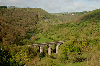
Monsal Dale is a valley in Derbyshire, England, in the White Peak limestone area of the Peak District National Park. It is a Site of Special Scientific Interest (SSSI), a Special Area of Conservation (SAC) (1) and part of a Europe-wide network called Natura 2000.

<span class="mw-page-title-main">Millers Dale</span> Valley in the Derbyshire Peak District

Millers Dale is a valley on the River Wye in Derbyshire, England, where there is also a hamlet of the same name.

<span class="mw-page-title-main">Great Longstone</span> Human settlement in England

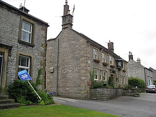
Great Longstone with Little Longstone is one of two villages in the local government district of Derbyshire Dales in Derbyshire, England. The population as taken at the 2011 Census was 843.

<span class="mw-page-title-main">Millers Dale railway station</span> Former railway station in Derbyshire, England

Millers Dale railway station was situated in Millers Dale, near Tideswell, in the Peak District.

<span class="mw-page-title-main">Cressbrook</span> Human settlement in England

Cressbrook is a village in the Peak District National Park in Derbyshire. It lies in Water-cum-Jolly Dale at the foot of Cressbrook Dale. Population details at the 2011 Census are included in the civil parish of Litton. Before its Enclosure Act of 1762 Cressbrook did not exist. It later grew up around a textile mill complex built alongside the River Wye, first by Richard Arkwright and then later by his son Richard, JL Philips and Brother Cotton Spinners and McConnel and Company.

The Monsal Trail is a cycling, horse riding and walking trail in the Derbyshire Peak District. It was constructed from a section of the former Manchester, Buxton, Matlock and Midland Junction Railway, which was built by the Midland Railway in 1863 to link Manchester with London and closed in 1968. The Monsal Trail is about 8.5 miles (13.7 km) long and opened in 1981. It starts at the Topley Pike junction in Wye Dale, 3 miles (4.8 km) east of Buxton, and runs to Coombs Viaduct, 1 mile (1.6 km) south-east of Bakewell. It follows the valley of the River Wye. The trail passes through Blackwell Mill, Chee Dale, Millers Dale, Cressbrook, Monsal Dale, Great Longstone, Hassop and Bakewell. The trail has numerous landmarks including Headstone Viaduct, Cressbrook Mill, Litton Mill and Hassop railway station, and passes through six tunnels.

<span class="mw-page-title-main">Wormhill</span> Human settlement in England

Wormhill is a village and civil parish in the High Peak district of Derbyshire, England, situated east by north of Buxton. The population of the civil parish including Peak Dale was 1,020 at the 2011 Census.

<span class="mw-page-title-main">Chee Dale</span> Valley in the Derbyshire Peak District, England

Chee Dale is a steep-sided gorge on the River Wye near Buxton, Derbyshire, in the Peak District of England.

<span class="mw-page-title-main">Deep Dale</span> Valley in the Derbyshire Peak District

Deep Dale is a short steep-sided gorge near Buxton, Derbyshire, in the Peak District of England. It is distinct from another Deep Dale, near Sheldon, 4 miles (6.4 km) to the east.

<span class="mw-page-title-main">Monk's Dale</span> Valley in the Derbyshire Peak District

Monk's Dale is a short steep-sided dry gorge near Buxton, Derbyshire, in the Peak District of England. The dale is cut into a plateau of farmland and lies to the east of the village of Wormhill. The head of the valley leads into Peter Dale to the north. Miller's Dale is at the foot of the valley to the south.

<span class="mw-page-title-main">Cressbrook Dale</span> Valley in the Derbyshire Peak District

Cressbrook Dale is a dry carboniferous limestone gorge near Bakewell, Derbyshire, in the Peak District of England. The dale is cut into a plateau of farmland and lies to the south east of the village of Litton. Cressbrook village is at the foot of the valley to the south.

<span class="mw-page-title-main">Tideswell Dale</span> Valley in the Derbyshire Peak District

Tideswell Dale is a short dry limestone valley near Tideswell village, Derbyshire, in the Peak District of England. There is a farmland plateau on either side. The foot of the valley leads into Miller's Dale on the River Wye, which the valley's Brook Head stream runs into.

<span class="mw-page-title-main">Derbyshire Dome</span> Geological formation of the Derbyshire Peak District

The Derbyshire Dome is a geological formation across mid-Derbyshire in England.

References

  1. OL24 White Peak area (Map). 1:25000. Explorer. Ordnance Survey.
  2. "A History of the Midland Railway Route through The Peak". Heritage Railway and Steam Train Rides Midlands, UK, Derbyshire Peak District. Retrieved 24 April 2020.
  3. "The Peak District, Derbyshire | Regional Studies | Limestone landscapes | Geology of Britain | British Geological Survey (BGS)". www.bgs.ac.uk. Retrieved 20 April 2020.
  4. Leach, John (1987). The Book of Buxton. Baracuda Books Limited. pp. 13–17. ISBN   0 86023 286 7.
  5. Tate. "'Peak District Views near Buxton, Including Ashwood Dale and Lovers' Leap', Joseph Mallord William Turner, ?1831". Tate. Retrieved 24 April 2020.
  6. "Lover's Leap". Collections in the Landscape. 10 February 2014. Retrieved 24 April 2020.
  7. Historic England. "Cowdale Quarry limestone extraction and processing site (1399726)". National Heritage List for England . Retrieved 24 April 2020.
  8. "Thirst House Cave". Wonders of the Peak. Retrieved 2 April 2020.
  9. McCloy, Andrew (2017). Peak District Boundary Walk: 190 Miles Around the Edge of the National Park. Friends of the Peak District. ISBN   978-1909461536.
  10. "Monsal trail". Peak District National Park. Retrieved 31 March 2020.
  11. "Chee Dale Upper". UK Climbing. Retrieved 31 March 2020.
  12. Railways of the Peak District. Blakemore & Mosley. 2003. ISBN   1-902827-09-0.
  13. "Raven Tor (Miller's Dale)". www.ukclimbing.com. Retrieved 16 April 2020.
  14. "Litton Mill - Graces Guide". www.gracesguide.co.uk. Retrieved 24 April 2020.
  15. Historic England. "Cressbrook Mill (Grade II*) (1158897)". National Heritage List for England. Retrieved 3 April 2020.
  16. "Monsal Dale Viaduct". www.engineering-timelines.com. Archived from the original on 25 October 2018. Retrieved 30 March 2019.
  17. Historic England. "Fin Cop promontory fort, bowl barrow and eighteenth century lime kiln with associated quarry (1011205)". National Heritage List for England . Retrieved 15 February 2014.
  18. "The Wye Valley SSSI" (PDF). Natural England. Retrieved 31 March 2020.
  19. "Deep Dale and Topley Pike | Derbyshire Wildlife Trust". www.derbyshirewildlifetrust.org.uk. Retrieved 2 April 2020.
  20. "TOPLEY PIKE & DEEP DALE SSSI" (PDF). Designated Site - Natural England. Retrieved 2 April 2020.
  21. "Chee Dale Nature Reserve". Derbyshire Wildlife Trust. Retrieved 31 March 2020.
  22. "Miller's Dale Quarry | Derbyshire Wildlife Trust". www.derbyshirewildlifetrust.org.uk. Retrieved 24 April 2020.
  23. "Priestcliffe Lees | Derbyshire Wildlife Trust". www.derbyshirewildlifetrust.org.uk. Retrieved 24 April 2020.
  24. "Derbyshire Dales National Nature Reserve (NE154)". Natural England. 18 July 2014. Retrieved 24 March 2020.
  25. "MONKS DALE SSSI" (PDF). Designated Site - Natural England. Retrieved 2 April 2020.
  26. "CRESSBROOK DALE SSSI" (PDF). Designated Site – Natural England. Retrieved 3 April 2020.