Wykeham, Scarborough

Last updated

Wykeham
North Yorkshire UK location map (2023).svg
Red pog.svg
Wykeham
Location within North Yorkshire
Population280 (2011 census) [1]
OS grid reference SE964834
Civil parish
  • Wykeham
Unitary authority
Ceremonial county
Region
Country England
Sovereign state United Kingdom
Post town SCARBOROUGH
Postcode district YO13
Police North Yorkshire
Fire North Yorkshire
Ambulance Yorkshire
UK Parliament
List of places
UK
England
Yorkshire
54°14′14″N0°31′19″W / 54.23728°N 0.52201°W / 54.23728; -0.52201
St Helen and All Saints' Church All Saints Church Wykeham.jpg
St Helen and All Saints' Church

Wykeham is a small village and civil parish in the Scarborough district of North Yorkshire, England, on the outskirts of Scarborough and the southern boundary of the North York Moors National Park.

Contents

It consists of a main street adjacent to the only pub; The Downe Arms. It lies around 7 miles (11 km) away from Scarborough and surrounding villages include: East Ayton, West Ayton, Snainton, Hutton Buscel, Brompton and Ruston. It has a cricket ground also which is hidden away in a small turning off the main road. To the north of the village is Wykeham Forest, which covers over 1,114 acres (451 ha). [2] [3]

According to the 2011 UK census, Wykeham parish had a population of 280, [1] a decrease on the 2001 UK census figure of 290. [4] In 2015, North Yorkshire County Council estimated that population had remained static at 280. [5]

A nunnery was established at Wykeham between 1140 and 1160 that was located to the south east of the village. [6] The Anglican church in the village is a grade II* listed building. St Helen's and All Saints Parish Church was built between 1853 and 1855 by William Butterfield. [7] [8] A primary school is tied to the church. Wykeham Church of England Primary School, which has a nominal capacity of 60 pupils, was rated Good by Ofsted in 2016. [9]

Charm Park, a Point-to-point racecourse is close by the village, as are the Wykeham Lakes. [10]

See also

Related Research Articles

<span class="mw-page-title-main">Great Ayton</span> Village and civil parish in North Yorkshire, England

Great Ayton is a village and civil parish in North Yorkshire, England. The River Leven flows through the village, which lies just north of the North York Moors. According to the 2011 Census, the parish has a population of 4,629.

<span class="mw-page-title-main">Aislaby, Scarborough</span> Village and civil parish in North Yorkshire, England

Aislaby is a village and civil parish in North Yorkshire, England. It is situated near the town of Whitby on the northern slopes of Eskdale just off the A171.

<span class="mw-page-title-main">Ampleforth</span> Village and civil parish in North Yorkshire, England

Ampleforth is a village and civil parish in North Yorkshire, England, 20 miles (32 km) north of York. The village is situated on the edge of the North York Moors National Park. The parish has a population of 883 according to the 2001 census, increasing to 1,345 at the 2011 Census, and includes Ampleforth College. The name Ampleforth means "the ford where the sorrel grows".

Birdsall is a village and civil parish in North Yorkshire, England. According to the 2001 census it had a population of 180, increasing to 343 at the 2011 Census. The village is about four miles south of Malton and the parish also includes the village of North Grimston.

<span class="mw-page-title-main">Bolton Abbey (village)</span> Village and civil parish in Craven, North Yorkshire, England

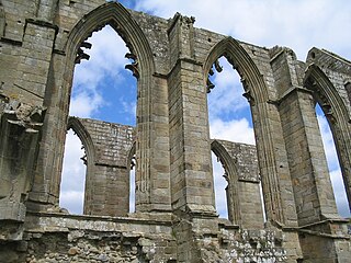
Bolton Abbey is a village and civil parish in the Craven district of North Yorkshire, England, 22 miles (35 km) north-west of Leeds. The village lies in Wharfedale, near the southern edge of the Yorkshire Dales National Park, and just north of the border with West Yorkshire.

<span class="mw-page-title-main">Brompton, east North Yorkshire</span> Civil parish in North Yorkshire, England

Brompton is a civil parish in the Scarborough district of North Yorkshire, England, containing the villages of Brompton-by-Sawdon and Sawdon.

<span class="mw-page-title-main">Broughton, Craven</span> Village and civil parish in North Yorkshire, England

Broughton is a village and civil parish in the former Craven District of North Yorkshire, England. The village is on the A59 road approximately 3 miles (5 km) west of Skipton.

<span class="mw-page-title-main">Burton Leonard</span> Village and civil parish in North Yorkshire, England

Burton Leonard is a village and civil parish in the Harrogate district of North Yorkshire, England, and approximately 7 miles (11 km) south from Ripon. In the 2001 Census, the population of the village was 654, which had risen to 690 by the time of the 2011 Census. In 2015, North Yorkshire County Council estimated the population had dropped to 670.

<span class="mw-page-title-main">Burythorpe</span> Village and civil parish in North Yorkshire, England

Burythorpe is a village and civil parish in North Yorkshire, England, about 4 miles (6 km) south of Malton. According to the 2001 census it had a population of 289, reducing marginally to 286 at the Census 2011. The Whitegrounds barrow is nearby.

<span class="mw-page-title-main">Romanby</span> Village and civil parish in North Yorkshire, England

Romanby is a village and civil parish in the Hambleton District of North Yorkshire, England. Romanby is situated just south-west of Northallerton, and at the 2001 UK census had a population of 6,051, increasing to 6,177 at the 2011 Census.

<span class="mw-page-title-main">Ingleby Arncliffe</span> Village and civil parish in North Yorkshire, England

Ingleby Arncliffe is a village and civil parish in North Yorkshire, England. It is situated between the A172 and A19 roads, 6.5 miles (10.5 km) north-east from Northallerton and 7 miles (11.3 km) south-east from the small market town of Stokesley, and is on the edge of the North York Moors National Park. The village is conjoined to its smaller neighbour, Ingleby Cross. Ingleby Arncliffe lies in the historic county of the North Riding of Yorkshire.

<span class="mw-page-title-main">Cloughton</span> Village and civil parish in North Yorkshire, England

Cloughton is a small village and civil parish in the Scarborough district of North Yorkshire, England.

<span class="mw-page-title-main">Hornby, Hambleton</span> Village and civil parish in North Yorkshire, England

Hornby is a village and civil parish in the Hambleton district of North Yorkshire, England. It lies on a minor road between Great Smeaton and Appleton Wiske.

<span class="mw-page-title-main">Staveley, North Yorkshire</span> Village and civil parish in North Yorkshire, England

Staveley is a village and civil parish in the Harrogate district of North Yorkshire, England. It is situated 4 miles (6.4 km) north of Knaresborough and near the A1(M) motorway. In the 2001 census, the village had a population of 444, which had risen to 450 by the time of the 2011 census. In 2015, North Yorkshire County Council estimated the population to have dropped to 440.

<span class="mw-page-title-main">Molescroft</span> Village and civil parish in the East Riding of Yorkshire, England

Molescroft is a village and civil parish in the East Riding of Yorkshire, England. It is situated approximately 0.5 miles (0.8 km) north-west of Beverley town centre adjoining its northern border. It lies to the north of the A1174 road and is on the eastern slopes of the Yorkshire Wolds.

<span class="mw-page-title-main">Settrington</span> Village and civil parish in North Yorkshire, England

Settrington is a village and civil parish in North Yorkshire, England, about 3 miles (5 km) east of Malton. It was historically part of the East Riding of Yorkshire until 1974 and part of the Ryedale district from 1974 until 2023.

<span class="mw-page-title-main">East Ayton</span> Village and civil parish in North Yorkshire, England

East Ayton is a village and civil parish in the Scarborough district of North Yorkshire, England.

<span class="mw-page-title-main">West Ayton</span> Village and civil parish in North Yorkshire, England

West Ayton is a village and civil parish in the Scarborough district of North Yorkshire, England. Located upon the west bank of the River Derwent adjacent to East Ayton.

<span class="mw-page-title-main">Hawsker</span> Villages in North Yorkshire, England

Hawsker is the name for the combined villages of High and Low Hawsker that straddle the A171 road 2.5 miles (4 km) southeast of Whitby, in North Yorkshire, England.

References

  1. 1 2 UK Census (2011). "Local Area Report – Wykeham Parish (1170217371)". Nomis. Office for National Statistics . Retrieved 5 March 2018.
  2. "Wykeham Forest, Scarborough - area information, map, walks and more". getoutside.ordnancesurvey.co.uk. Retrieved 14 October 2021.
  3. "Wykeham Forest Plan". forestryengland.uk. Retrieved 14 October 2021.
  4. UK Census (2001). "Local Area Report – Wykham Parish (36UG051)". Nomis. Office for National Statistics . Retrieved 14 October 2021.
  5. "2015 Population Estimates Parishes" (PDF). northyorks.gov.uk. December 2016. p. 17. Archived from the original (PDF) on 4 June 2022. Retrieved 14 October 2021.
  6. Jennings, B (1999). Yorkshire Monasteries. ISBN   1-85825-105-2.
  7. "St Helen & All Saints Parish Church". www.achurchnearyou.com. Retrieved 14 October 2021.
  8. Historic England. "All Saints Church (Grade II*) (1316131)". National Heritage List for England . Retrieved 14 October 2021.
  9. "Wykeham Church of England Voluntary Controlled Primary School URN: 121526". reports.ofsted.gov.uk. 8 October 2020. Retrieved 14 October 2021.
  10. Wood, Alexandra (9 February 2021). "North Yorkshire Water Park near Scarborough invests £1m in new facilities including first wakeboarding line in county". The Yorkshire Post. Retrieved 14 October 2021.

Commons-logo.svg Media related to Wykeham at Wikimedia Commons