The Brecon Beacons, or Bannau Brycheiniog ( ), is a mountainous region and national park in Wales. The name "Brecon Beacons" was originally applied only to the mountain range south of Brecon, Powys, which is now also known as the Central Beacons. The range includes South Wales's highest mountain, Pen y Fan, its twin summit Corn Du, and Craig Gwaun Taf, which are the three highest peaks in the range.

The Cambrian Mountains are a series of mountain ranges in Wales. The term Cambrian Mountains used to apply to most of the upland of Wales, and comes from the country's Latin name Cambria. Since the 1950s, its application has become increasingly localised to the geographically homogeneous Mid Wales uplands, known in Welsh as Elenydd, which extend from Plynlimon (Pumlumon) to Radnor Forest in the east and Mynydd Mallaen to the south. This barren and sparsely populated 'wilderness' has been referred to as the Desert of Wales. The area includes the sources of the River Severn and River Wye and was unsuccessfully proposed as a national park in the 1960s and 1970s. The highest point of the range is Plynlimon, at 2,467 feet (752 m).

Plynlimon, or Pumlumon in Welsh, is the highest point of the Cambrian Mountains in Wales, and the highest point in Mid Wales. It is a massif that dominates the surrounding countryside and is the highest point of Ceredigion.

Glyder Fawr is a mountain in Snowdonia, Wales, the highest peak in the Glyderau range at just over 1,000 metres. It is the fifth-highest mountain in Wales and has several walking and scrambling routes leading to its summit. According to Sir Ifor Williams, the word "Glyder" derives from the Welsh word "Gludair", meaning a heap of stones.

Elidir Fawr is a mountain in Snowdonia, north Wales, the northernmost peak in the Glyderau. Its name means 'Big Elidir', named after a legendary warrior king of the 6th century also known as Eliffer Gosgorddfawr.

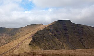
Pen y Fan is the highest peak in South Wales, situated in Brecon Beacons National Park. At 886 metres (2,907 ft) above sea-level, it is also the highest British peak south of Cadair Idris in Snowdonia. It is the highest point of the historic county of Brecknockshire. The twin summits of Pen y Fan and Corn Du at 873 metres (2,864 ft) were formerly referred to as Cadair Arthur or 'Arthur's Seat'.

Waun Fach is, with a summit height of 811 metres (2,661 ft), the highest mountain in the Black Mountains in south-eastern Wales. It is one of the three Marilyns over 600 m that make up the range, the others being Black Mountain and Mynydd Troed. To the north Rhos Fawr and the Radnor Forest can be seen. It is the third highest mountain in Britain south of Snowdonia. It is situated at the head of the Grwyne Fechan valley, above and to the west of the Grwyne Fawr reservoir. It has an undistinguished rounded summit. The nearby tops on the ridge, Pen Trumau and Pen y Gadair Fawr, although lower, are very much more recognisable.
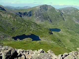
Y Garn is a mountain in Snowdonia, North Wales, part of the Glyderau.
Pen Pumlumon Llygad-bychan is a subsidiary summit of Pen Pumlumon Fawr and the third highest summit on the Plynlimon massif, a part of the Cambrian Mountains in the county of Ceredigion, Wales. It is not named on Ordnance Survey walking maps.

Pumlumon Fach is a top of Pen Pumlumon Fawr on the Plynlimon massif, a part of the Cambrian Mountains in the county of Ceredigion, Wales. It lies on small ridge heading north-west from the summit of Pen Pumlumon Fawr.
Pen Pumlumon Arwystli is the second highest summit on the Plynlimon massif, a part of the Cambrian Mountains in the county of Ceredigion, Wales.

Corn Du is a summit of the twin topped Pen y Fan and the second highest peak in South Wales at 871.5 m (2,864 ft), situated in the Brecon Beacons National Park. The summit itself is marked by a well structured Bronze Age cairn with a central burial cist like that on nearby Pen y Fan. The two summits are visible from great distances owing to their height above the surrounding moorland, and are famous landmarks. The views from the peaks are also panoramic and very extensive, the Black Mountain and Fforest Fawr being especially obvious to the west. Mynydd Epynt is visible to the north behind the county town of Brecon, and other parts of the escarpment to the east.

Gau Graig is a subsidiary summit of Cadair Idris in the Snowdonia National Park, in Gwynedd, northwest Wales. It lies to the east of Mynydd Moel on a broad grassy plateau. It marks the eastern end of the Cadair Idris ridge.

Pen y Gadair Fawr is an 800 metres (2,625 ft) high subsidiary summit of Waun Fach and the second highest peak in the Black Mountains in south-eastern Wales. Marked by a medium-sized cairn, it is a much more distinguished top than its parent 1.5 km to the northwest. Its 658 metres (2,159 ft) high top Pen Twyn Mawr is about 2 km to the southeast.

Foel-goch is a mountain in Snowdonia, north-west Wales, and forms part of the Glyderau range, in Gwynedd. It lies in between Y Garn and Mynydd Perfedd.

Mynydd Perfedd is a mountain in Snowdonia, Wales, forming part of the Glyderau. The summit has a shelter cairn, offering good views of Foel-goch's north-eastern face, and the Carneddau.

Rhos Fawr is a mountain summit in the Radnor Forest, a rather isolated dome of hills to the north of the village of New Radnor. The local rocks are sedimentary shales and mudstones with some Silurian limestone. With a height of 660 metres (2,170 ft), it is the highest point in the Radnor Forest and the historic county top of Radnorshire.

Y Garn Goch is a hill in the Brecon Beacons National Park in the east of Carmarthenshire, Wales. The name means the 'red cairn'. It lies near the village of Bethlehem, three miles southwest of Llangadog and four miles east of Llandeilo on the southern side of the broad Towy Valley. It is also commonly known as either Garn Goch or Carn Goch. Current owners and land managers are the Brecon Beacons National Park Authority.
Pen y Garn is a mountain in the Cambrian Mountains, Mid Wales standing at 611 metres above sea level.
