Yadgir

Last updated

Yadagiri
City
Yadgir town view from fort.jpg
A view of Yadgiri city
India Karnataka location map.svg
Red pog.svg
Yadagiri
Location in Karnataka, India
Coordinates: 16°46′N77°08′E / 16.77°N 77.13°E / 16.77; 77.13
CountryFlag of India.svg  India
State Karnataka
District Yadgir
Lok Sabha Constituency Raichur
Area
  Total5.6 km2 (2.2 sq mi)
Elevation
389 m (1,276 ft)
Population
 (2011) [1]
  Total74,294
  Density10,500.36/km2 (27,195.8/sq mi)
Demonym Yadgirians
Languages
  Official Kannada
Time zone UTC+5:30 (IST)
PIN
585201 / 585202
Telephone code08473
Vehicle registration KA-33
Website www.yadgircity.mrc.gov.in
Yadgir Town Map Yadgir Town Map.jpg
Yadgir Town Map
Yadgir Taluk Zilla Panchayat Map before creation Gurmitkal Taluk Yadgir Taluk Zilla Panchayat Map - OLD.jpg
Yadgir Taluk Zilla Panchayat Map before creation Gurmitkal Taluk
Yadgir Taluk Panchayat Map before creation Gurmitkal Taluk Yadgir Taluk Panchayat Map - OLD.jpg
Yadgir Taluk Panchayat Map before creation Gurmitkal Taluk
Yadgir Taluk Map before creation Gurmitkal Taluk Yadgir Taluk - Old.jpg
Yadgir Taluk Map before creation Gurmitkal Taluk
Yadgir TMC Wards Yadgir TMC Wards.jpg
Yadgir TMC Wards

Yadgiri is a city and the administrative headquarters of Yadgir district in the Indian state of Karnataka. It is also the administrative headquarters of Yadgir Taluka, one of the six taluks of Yadgir.

Contents

Geography

Yadagiri Taluk Map Yadagiri Taluk.jpg
Yadagiri Taluk Map

Yadgir town covers an area of 5.6 square kilometres (2.2 sq mi). [2] The Bhima River flows through the town.

Overview

Yadgir, historically known as Yetagiri, [3] is dotted with many historical monuments and has a hill fort with three rounds of fortifications. There are three ancient temples, medieval mosques, tanks and wells on top of the hill. A pond, the Sanna Kere is located in the heart of the town. [4]

Demographics

In 2011, Yadgir had a population of 1,172,985 of whom males were 591,104 and females 581,881 respectively. In the 2001 census, Yadgir had a population of 956,180 of whom males were 482,347 and 473,933 were females. Yadgir district's population constitutes 1.92 percent of the total population of Karnataka. In the 2001 census, this figure for Yadgir district was at 1.81 percent.

There was a change of 22.67 percent in the population compared to the population as per the 2001 census. In the census of 2001, Yadgir district recorded an increase of 20.12 percent to its population compared to 1991.

The initial provisional data released by census India 2011 show that the density of Yadgir district for 2011 is 224 people per km2. In 2001, Yadgir district's density was 183 people per km2. Yadgir district covers an area of 5,225 km2.

The average literacy rate of Yadgir in 2011 was 52.36, compared to 39.90 in 2001. Male and female literacy were 63.33 and 41.31 respectively. In the 2001 census, the same figures stood at 51.35 and 28.32. The total number of literates in Yadgir district was 516,940, of whom male and female were 313,797 and 203,143 respectively. [5]

Culture and religion

Mylapura Betta (Hill), yadgir Deepak0429.jpg
Mylapura Betta (Hill), yadgir

In Yadgir, there are many spiritual places, e.g., Mayllapur Mallayya. The temple of Shree Kshetra Mouneshwara in Tinthani in Surapura Taluka attracts more than 100,000 devotees every year. In Gurmitkal is situated the famous Mata Manikeshwari temple. The sofi sarmast durga is in the village of Sagar in the Shahapur taluka. The Durga attracts thousands of people in the urus. and Darga Shah Jeewan Shah is located near the Gunj area of Yadgir.

Irrigation

Agriculture in the district is mainly rainfed. The net area irrigated to the net area sown is 38%, which is above the state average of 24%. Krishna, Bhima and Dhoni rivers flow through the district. The irrigation projects in the district are Hattikuni and Soudagar. There are 36 lift irrigation schemes and 445 minor irrigation tanks in the district.

History

The town was part of the empire of the Western Chalukyas from the 10th to the 12th centuries. The name Yadgir (historically Yetagiri [3] ) is derived from its early medieval rulers, the 'Yadavas'. Their establishments were on a hill ('giri' in Kannada means hill). Major economic development of the city took place under Philip Meadows Taylor, the British administrator of the principality of Shorapur.[ citation needed ]

Heritage and tourist sites

  1. Yadgir Fort
  2. Vanadurga Fort

Transport

Yadgir is connected by road and rail.

Yadgir Railway Station Deepak0405.jpg
Yadgir Railway Station
Railway

Yadgir has a broad gauge railway station, Yadgir railway station , [6] and lies between Mumbai and Chennai. It comes under the South Central Railway under the Guntakal division. The city is connected to Gulbarga, 78 km. away by rail and 84 km. away by road. From Raichur, its distance is 81 km. It is located between the two districts - Gulbarga and Raichur. [7]

Road

State Highway 15 passes through the city connecting the city to Bijapur and Hyderabad. Important cities connected through buses to the city are Bengaluru, Hubballi, Dharwad, Belagavi, Shirasi, Hosapete, Vasco da Gama in Goa, Hyderabad, Ballari, Raichur. [8]

Industry

Two rivers flow through the Yadgir district, the Krishna and the Bhima. There is a lot of scope for industrialization. [ original research? ] A sugar factory and a fuel factory, "Core Green", are established near Hiretumkur village. [9] Recently, rich uranium deposits have been found in the Gogi belt, covering the villages of Gogi, Ukkinal & Darshanapur in Shahapur taluk and Thinthini & other places in Surapur taluk. Uranium mined and processed here will be used for defense and power generation purposes.[ citation needed ]. Near Saidapur in Yadgir taluk there is an industrial area called Kadechur-Badiyal Industrial Area, which estimates at 3000 acres. The Karnataka government has approved proposals by 67 pharmacy companies to set up their units in the Kadechar-Badiyal drug park in the same industrial area. These companies are expected to invest over 2812 crores and generate over 11000 jobs.

Notable people

Related Research Articles

<span class="mw-page-title-main">Kalaburagi</span> City in Karnataka, India

Kalaburagi, formerly known as Gulbarga, is a city in the Indian state of Karnataka. It is the administrative headquarters of the Kalaburagi district and is the largest city in the region of North Karnataka (Kalyana-Karnataka). Kalaburagi is 568 km north of the state capital city of Bangalore. It was incorporated into the newly formed Mysore State through the States Reorganisation Act in 1956.

<span class="mw-page-title-main">Raichur district</span> District of Karnataka in India

Raichur District is an administrative district in the Indian state of Karnataka. It is located in the northeast part of the state and is bounded by Yadgir district in the north, Bijapur and Bagalkot district in the northwest, Koppal district in the west, Bellary district in the south, Jogulamba Gadwal district of Telangana and Kurnool district of Andhra Pradesh in the east.

Sindhanur is a city and taluk headquarter of Sindhanur taluk of Raichur District in Karnataka. The river Tungabhadra covers the irrigation area by left bank canal. Most of the land in the field is composed of cultivable black soil. Paddy is cultivated using the Tungabhadra River water. Sindhanur is also known as the Paddy Granary of Raichur. With the availability of Tungabhadra river water, paddy rice is grown twice a year. Sindhanur is the place where the majority of tractor sales take place in Asia. as agricultural activities take place year-round. Sona Masuri and Basmati rice are grown in Sindhanur.Amba Matha also spelled as Amba Mutt is a village near Somalapura in the Sindhanur taluk. Amba Matha is a holy place, Sri Amba Devi Temple is located in the village.

<span class="mw-page-title-main">Shahapur, Karnataka</span> Town in Karnataka, India

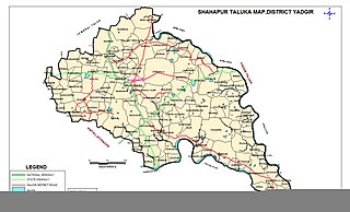
Shahapur is a city and taluka headquarter located in the Yadgir district of Indian state of Karnataka. Shahapur is 597 km north of Bangalore and well connected by road to Gulbarga (70 km), Hyderabad (240 km), Bidar (160 km), Raichur (90 km) and Yadgir (32 km).

<span class="mw-page-title-main">Kalaburagi district</span> District of Karnataka in India

Kalaburagi district, formerly known as Gulbarga district, is one of the 31 districts of Karnataka state in southern India. Kalaburagi city is the administrative headquarters of the district. The district is the headquarters of Kalaburagi division.

Sagar is a village in the Shahapur taluk of Yadgir district in Karnataka state, India. Sagar is ten kilometres south-southwest (SSW) of the town of Shahapur and 6 km from the Shahapur-Bangalore highway. Sagar is specifically known as Dodda Sagar to differentiate it from Halisagar The nearest railhead is in Yadgir.

Bhimarayanagudi is a town administered by a notified area committee in Shahpur Taluk of Yadgir district, in the state of Karnataka, India. It is approximately 4 km by road north of Shahpur town. It is also referred to as B.Gudi and Bhimarayanagudi camp.

Chitapur or Chittapur is a town and taluk in Kalaburagi district in the state of Karnataka, India. It is also the headquarters of the Chittapur taluk. It is known for polished stones and toor dal.

<span class="mw-page-title-main">Gurmatkal</span> Place in Karnataka, SH 16 HYD ROAD GKL India

Gurmitkal, or Gurumithakal, is a panchayat town in the northeast of Yadgir district in the Indian state of Karnataka. Administratively, it is under Gurumitkal Taluka.

<span class="mw-page-title-main">Lingasugur</span> Town in Karnataka, India

Lingasugur is a municipal town in Raichur district in the Indian state of Karnataka. There are many Temples, hills and forts (Quila). The festivals of Muharram and Maha Shivaratri are important here. Mudgal in Lingasugur taluk has a very ancient fort. It has often been mentioned in the autobiography of Philip Meadows Taylor. Lingasugur, then known as Chavani was the site of a major British cantonment in the region.

Sedam or Seram is a town in Kalaburagi district in the Indian state of Karnataka. It is also the headquarters of the Sedam Taluka.

Gogikona is a village in the southern state of Karnataka, India. It is located in the Shahapur taluka of Yadgir district in Karnataka. Gogikona is a companion village to Gogipeth which lies less than half a kilometre to the northwest, across a small stream, and together the two are often known as "Gogi".

Gogipeth is a village in the southern state of Karnataka, India. It is located in the Shahapur taluk of Yadgir district in Karnataka. Gogipeth is a companion village to Gogikona which lies less than half a kilometre to the southeast, across a small stream, and together the two are often known as "Gogi".

<span class="mw-page-title-main">Wadgera Taluka</span> Taluka in Karnataka, India

Wadgera is a taluka panchayat in the southern state of Karnataka, India. Administratively, Wadgera is in the Yadgir district in Karnataka. It was created 2017 out of the southern portion of Shahapur Taluka. The administrative center is the village of Wadgera, 23 km by road south of the City of Yadgir and 39 km by road southeast of the town of Shahapur. The nearest rail station and the nearest railhead are in Yadgir.

Agastihal is a small village in the southern state of Karnataka, India. Administratively Agastihal is under Gundgurthi panchayat village, Wadgera Taluka of Yadgir district in Karnataka. Agastihal is 2.7 km by road southwest of Gundgurthi, and 7 km by road northeast of Hattigudur.

Agnihal is a village in the southern state of Karnataka, India. Administratively, it is under Gonal panchayat village, Wadgera Taluka of Yadgir district in Karnataka.

<span class="mw-page-title-main">Yadgir district</span> District of Karnataka in India

Yadgir District is one of the 31 districts of Karnataka state in southern India.This district was carved out of Kalaburagi district as the 30th district of Karnataka on 10 April 2010. Yadgir town is the administrative headquarters of the district. The district occupies an area of 5,160.88 km2 (1,992.63 sq mi).

Wanadurga is a village in Shahapur taluka of Yadgir district in Karnataka state, India. Wanadurga is twelve kilometres by road west of Sagar, and four kilometres south-southwest of Hoskera. The nearest railhead is in Yadgir.

Badiyal is a panchayat village in the southern state of Karnataka, India. Administratively, Badiyal is under the Yadgir Taluka of Yadgir district in Karnataka. Badiyal is 13.5 km by road east of the village of Bendebembli and 41 km by road south of the town of Yadgir. The nearest rail station is Chegunda Station, and the nearest railhead is in Yadgir.

Aldhal is a village in the southern state of Karnataka, India. Administratively, it is under Kakkasgera panchayat village, Shahapur Taluka of Yadgir district in Karnataka. Aldhal is 5 km by road west of the village of Wanadurga and 9.5 km by road southwest of the village of Hoskera. The nearest railhead is in Yadgir.

References

  1. http://www.censusindia.gov.in/pca/SearchDetails.aspx?Id=666255 [ dead link ]
  2. "Population of Corporation/CMC/TMC/TP: Population 2001 Census". Directorate of Municipal Administration, Government of Karnataka. Archived from the original on 10 April 2009.
  3. 1 2 "A strong hold on the past". 3 January 2011. Retrieved 7 January 2011.
  4. Naraboli, Ravikumar (5 June 2016). "Lumbini Park in Yadgir is a picture of neglect". The Hindu. ISSN   0971-751X . Retrieved 10 December 2019.
  5. "Yadgir District Population Census 2011-2021, Karnataka literacy sex ratio and density".
  6. "Yadgir District Map Showing Railway Line". Yadgir District.
  7. "Yadgir railway station plays it cool". www.thehindu.com. Retrieved 8 October 2017.
  8. "NEKRTC Yadgir Division". www.nekrtc.com. Retrieved 8 October 2017.
  9. Srinivas Sirnoorkar (13 May 2010). "India's third uranium mining unit at Gogi". Deccan Herald.