Related Research Articles

The black-tailed godwit is a large, long-legged, long-billed shorebird first described by Carl Linnaeus in 1758. It is a member of the godwit genus, Limosa. There are four subspecies, all with orange head, neck and chest in breeding plumage and dull grey-brown winter coloration, and distinctive black and white wingbar at all times.

Lake Eyasi is a lake located in Karatu District of Arusha Region in north Tanzania. Lake Eyasi is the largest body of water in Arusha region. It is a seasonal shallow endorheic salt lake on the floor of the Great Rift Valley at the base of the Serengeti Plateau, just south of the Serengeti National Park and immediately southwest of the Ngorongoro Crater in the Crater Highlands of Tanzania. The lake is elongated, orientated southwest to northeast, and lies in the Eyasi-Wembere branch of the Great Rift Valley.
The Kipengere Range, also known as the Livingstone Mountains, lies entirely in Njombe Region in southwest Tanzania at the northern end of Lake Nyasa. Near Lake Nyasa they are known as the Kinga Mountains. It is a plateau-like ridge of mountains running southeastwards from the basin of the Great Ruaha River in the north to that of the Ruhuhu River in the south, and forms part of the eastern escarpment of the East African Rift. The range is mostly clad in montane grasslands, renowned for their botanical diversity and displays of flowers, with montane evergreen forests mostly in stream valleys.

The Erie National Wildlife Refuge is an 8,777-acre (3,552 ha) National Wildlife Refuge located in Crawford County, Pennsylvania. Named after the Erie tribe, it was established to provide waterfowl and other migratory birds with nesting, feeding, brooding, and resting habitat.
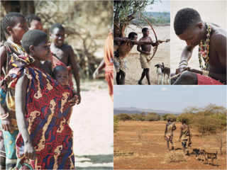
The Hadza, or Hadzabe, are a Tanzanian indigenous ethnic group mostly based in southwest Karatu District of Arusha Region. They live around Lake Eyasi in the central Rift Valley and in the neighboring Serengeti Plateau. There are, as of 2015, between 1,200 and 1,300 Hadza people living in Tanzania, however only around 400 Hadza still survive exclusively based on the traditional means of foraging. Additionally, the increasing impact of tourism and encroaching pastoralists pose serious threats to the continuation of their traditional way of life.
Grays Lake is a wetland in Idaho, United States. It lies in Bonneville County and Caribou County. Grays Lake National Wildlife Refuge was established in the area in 1965. Ranching is the predominant use of surrounding lands.

The wildlife of Zambia refers to the natural flora and fauna of Zambia. This article provides an overview, and outline of the main wildlife areas or regions, and compact lists of animals focusing on prevalence and distribution in the country rather than on taxonomy. More specialized articles on particular groups are linked from here.

The Zambezian flooded grasslands is an ecoregion of southern and eastern Africa that is rich in wildlife.
The biomes and ecoregions in the ecology of Zambia are described, listed and mapped here, following the World Wildlife Fund's classification scheme for terrestrial ecoregions, and the WWF freshwater ecoregion classification for rivers, lakes and wetlands. Zambia is in the Zambezian region of the Afrotropical biogeographic realm. Three terrestrial biomes are well represented in the country . The distribution of the biomes and ecoregions is governed mainly by the physical environment, especially climate.

The Kimberley tropical savanna is a tropical and subtropical grasslands, savannas, and shrublands ecoregion in northwestern Australia, covering portions of Western Australia and the Northern Territory south of the Timor Sea.

The Coongie Lakes is a freshwater wetland system located in the Far North region of South Australia. The 21,790-square-kilometre (8,410 sq mi) lakes system is located approximately 1,046 kilometres north of the Adelaide city centre. The wetlands includes lakes, channels, billabongs, shallow floodplains, deltas, and interdune swamps. It lies on the floodplain of Cooper Creek, an ephemeral river flowing through a desert landscape in the Lake Eyre Basin which rarely, after occasional large floods, empties into Lake Eyre. The wetland system has been recognised both as being of international importance by designation under the Ramsar Convention with a listing on 15 June 1987 and being nationally important within Australia with a listing in A Directory of Important Wetlands in Australia (DIWA). Its extent includes the regional town of Innamincka, the Malkumba-Coongie Lakes National Park, the Innamincka Regional Reserve, the Strzelecki Regional Reserve and the Coongie Lakes Important Bird Area.
The Lowbidgee Floodplain extends from Balranald to near Waradgery Station, about 20 km (12 mi) west of Hay, in south-western New South Wales. The Lowbidgee Floodplain is part of the Traditional lands of the Nari Nari and Muthi Muthi Aboriginal peoples.
The North Victorian Wetlands, also known as the Kerang Wetlands, comprise an extensive series of over 100 freshwater, brackish and saline lakes and swamps on the floodplain of the Loddon River where it enters the Murray valley, in the vicinity of the town of Kerang, in northern Victoria, south-eastern Australia. They are important for a variety, and sometimes large numbers, of waterbirds.
The Wembere River is a river located in north western Singida Region, Tanzania. The river is part of the water basin of Lake Eyasi.
The Cooper Floodplain below Windorah comprises a 1741 km2 tract of floodplain of the Cooper Creek river system, below the town of Windorah, in the Channel Country of western Queensland, Australia. When inundated it is an important breeding site for large numbers of waterbirds.

The Mbulu Highlands is a plateau in north-central Tanzania.
The Northern Acacia–Commiphora bushlands and thickets are a tropical grasslands, savannas and shrublands ecoregion in eastern Africa. The ecoregion is mostly located in Kenya, extending north into southeastern South Sudan, northeastern Uganda and southwestern Ethiopia and south into Tanzania along the Kenya-Tanzania border.
The Southern Eastern Rift is a freshwater ecoregion in Kenya and Tanzania.
References
| | This Tanzania location article is a stub. You can help Wikipedia by expanding it. |
Coordinates: 4°0′1.11″S34°59′59.7″E / 4.0003083°S 34.999917°E