Related Research Articles

Lewis County is a county in the U.S. state of Washington. As of the 2010 census, the county's population was 75,455. The county seat is Chehalis, and its largest city is Centralia. The county was created as Vancouver County on December 19, 1845, by the Provisional Government of Oregon, named for George Vancouver. In 1849, the county name was changed, to honor Meriwether Lewis. At the time, the county included all U.S. lands north of the Cowlitz River, including much of the Puget Sound region and British Columbia.

Cowlitz County is a county located in the U.S. state of Washington. As of the 2010 census, its population was 102,410. The county seat is Kelso, and its largest city is Longview. The county was formed in April 1854. Its name derives from the anglicized version of the Cowlitz Indian term Cow-e-liske, meaning either 'river of shifting sands' or 'capturing the medicine spirit.'

Morton is a city in Lewis County, Washington, United States. The population was 1,126 at the 2010 census.

Cougar is an unincorporated community and former town in Cowlitz County, Washington. Cougar is located around 30 miles (48 km) northeast of Woodland along Washington State Route 503 and situated along the northwest bank of Yale Lake, a reservoir on the Lewis River. The population was 122 at the 1990 Census, when it was still incorporated as a town, but disincorporated before the 2000 Census. The Cougar community is part of the Woodland School District, a K-12 school district of about 2,200 students. Cougar is the nearest community to Mount St. Helens, which lies 13 miles (20.9215 km) to its northeast. The eruption of Mount St. Helens on May 18, 1980 was the deadliest and most economically destructive volcanic event in the history of the United States.

The Long Beach Peninsula is an arm of land on the southern coast of the state of Washington in the United States. Entirely within Pacific County, it is bounded on the west by the Pacific Ocean, the south by the Columbia River, and the east by Willapa Bay. Leadbetter Point State Park and Willapa National Wildlife Refuge are at the northern end of the peninsula and Cape Disappointment is at the southern end, with Pacific Pines State Park located in between.

Yale is an unincorporated community in Cowlitz County, Washington, northeast of the city of Woodland. Yale is located 22.4 miles (36.0 km) northeast of Woodland along Washington State Route 503 and situated between Yale Lake and Lake Merwin, both reservoirs on the Lewis River. The rock-fill hydro-electric Yale Dam is nearby. Named for Yale University, the only school teaching forestry in the 19th century, the Yale community is part of the Woodland School District, a K-12 school district of about 2,200 students.

Ariel is an unincorporated community in Cowlitz County, Washington. Ariel is located 11 miles (18 km) northeast of the city of Woodland along Washington State Route 503, situated north of the Lewis River and on the northwest bank of Lake Merwin. The Ariel community is part of the Woodland School District, a K-12 school district of about 2,200 students.
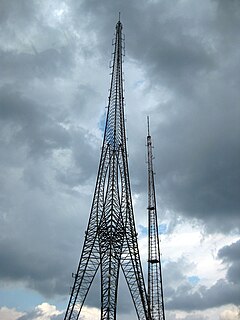
The Hughes Memorial Tower is a radio tower located in Washington, D.C. at 6001 Georgia Avenue, near the intersection of 9th Street NW and Peabody Street NW. At 761 ft (232 m), it is the tallest structure of any kind within Washington, D.C., surpassing the Washington Monument by more than 200 ft (61 m) and the WTTG Television Tower by 55 ft (17 m). And the second tallest freestanding structure in the entire Baltimore-Washington metropolitan area, after the 809-foot tall River Road Tower in Bethesda, MD.
Evaline is a small unincorporated community in Washington, United States, south of Napavine and 3 miles north of Winlock.
The Yelm–Tenino Trail is a rail trail located in Thurston County, Washington, United States. The 14.5-mile (23.3 km) long cycling and walking trail has been constructed along the route of a former Burlington Northern Railroad line. The trail runs parallel to State Route 507 and intersects with the Chehalis Western Trail. Trailheads are located at the trail termini in the towns of Yelm and Tenino as well as in the town of Rainier.
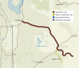
The Cedar River Regional Trail is a partially paved 17.3-mile (27.8 km) rail trail in Washington. The Cedar River Trail was the former mainline of the Milwaukee Road.
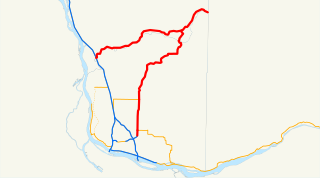
State Route 503 (SR 503) is a 54.11-mile-long (87.08 km) state highway serving Clark and Cowlitz counties in the U.S. state of Washington. The highway travels north from a short concurrency with SR 500 in Orchards through Battle Ground, the eastern terminus of SR 502, and communities in rural Clark County before crossing the Lewis River on the Yale Bridge. SR 503 intersects its spur route and turns west to parallel the Lewis River downstream to Woodland, where the highway ends at an interchange with Interstate 5 (I-5). The highway was part of the Lewis River Road, signed as State Road 15, from 1909 until 1919. The current route of SR 503 was split between Secondary State Highway 1S (SSH 1) from Woodland to Battle Ground and SSH 1U from Battle Ground to Orchards in 1937, combined to form SR 503 during the 1964 highway renumbering. A spur route, established in 1991, travels northeast into the Gifford Pinchot National Forest along Yale Lake, serving the community of Cougar.
Cinebar is an unincorporated community in Lewis County, Washington, United States. It is located between State Route 508 and U.S. Route 12. Named for the cinnabar present in the mountains to the northeast, Cinebar is a rural area with a post office and fire station on State Route 508. Other towns near Cinebar include Silver Creek, Salkum, Morton, Onalaska, Napavine, Chehalis, and Centralia.
Yale Dam is a 323-foot high earth-type hydroelectric dam on the Lewis River, in the U.S. state of Washington, owned by PacifiCorp. It is located on the border between Cowlitz County and Clark County. Its reservoir is called Yale Lake. The dam's power plant generates 134 megawatts.

Yale Lake is a 3,780 acre reservoir on the Lewis River in the U.S. state of Washington. It lies on the border between Clark County and Cowlitz County. It was created in 1953 with the construction of Yale Dam.
Alpha is an unincorporated community located in Lewis County, Washington about 3.5 miles away from Cinebar. Due to its rural setting with little settlement concentration, it did not meet qualifications as a Census Designated Place, a program used by the U.S. Census Bureau for unincorporated communities. Alpha appears on the Mayfield Lake U.S. Geological Survey Map. Alpha is located within the Pacific time zone UTC-8. It is the home to the Shoestring Cemetery, located on the Main Avenue, Washington State Route 508.
Gee Creek is a 4th order tributary to the Columbia River, a.k.a. small creek, within Clark County, Washington named for William Gee, an early pioneer upon whose land the stream arose from. The Upper Gee Creek watershed, with an 8.7-square-mile (23 km2) drainage basin, is completely located within the Ridgefield quadrangle. The mainstem extends approximately 11.5 miles (18.5 km), of which 4.9 miles (7.9 km) are located within the Upper Gee Creek basin. Originating in the hills along Interstate 5, through Ridgefield, Washington and empties into a series of lakes on the Columbia River Floodplain. Abrams Park in Ridgefield is a local access point for Gee Creek and since 2003, has had a stream flow gauge installed to collect hydrological data. The lowest segment of Gee Creek meanders for 3 miles (4.8 km) through the Ridgefield National Wildlife Refuge.
The Port of Camas/Washougal is a port on the Columbia River serving the communities of Camas and Washougal, Washington in Clark County, Washington. The port was established in 1935 by a vote of the people in a special election and today encompasses the port, a marina, Grove Field airport and an industrial park. The port provides facilities and services for land, air, and water-borne use, and commerce to enhance employment and recreational opportunities for the communities of Camas and Washougal.
Long is an unincorporated community in Columbia County, in the U.S. state of Washington. An early variant name was Milton Mills.
The Nicolet State Trail is an 89-mile state designated trail running through Nicolet National Forest in Florence, Forest, and Oconto Counties in Wisconsin.
References
- ↑ "Washington State Tourism Yale Park." Washington State Tourism. N.p., n.d. Web. 5 July 2010. <http://www.experiencewa.com/attraction.aspx?id=8833>.
- ↑ "Yale Dam - Recreation - LewisRiver.com." LewisRiver.com. N.p., n.d. Web. 5 July 2010. <http://lewisriver.com/yale.html>.
Coordinates: 46°01′36″N122°19′04″W / 46.02667°N 122.31778°W