
Jiangsu is an eastern coastal province of the People's Republic of China. It is one of the leading provinces in finance, education, technology, and tourism, with its capital in Nanjing. Jiangsu is the third smallest, but the fifth most populous and the most densely populated of the 23 provinces of the People's Republic of China. Jiangsu has the highest GDP per capita of Chinese provinces and second-highest GDP of Chinese provinces, after Guangdong. Jiangsu borders Shandong in the north, Anhui to the west, and Zhejiang and Shanghai to the south. Jiangsu has a coastline of over 1,000 kilometres (620 mi) along the Yellow Sea, and the Yangtze River passes through the southern part of the province.

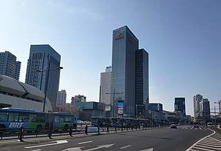
Yancheng is a prefecture-level city in northeastern Jiangsu province, People's Republic of China. As the city with the largest jurisdictional area in Jiangsu, Yancheng borders Lianyungang to the north, Huai'an to the west, Yangzhou and Taizhou to the southwest, Nantong to the south, and the Yellow Sea to the east.

Quivira National Wildlife Refuge is located in south central Kansas near the town of Stafford. It lies mostly in northeastern Stafford County, but small parts extend into southwestern Rice and northwestern Reno Counties. Its proximity to the Central Flyway migration route and the salt marshes on the refuge combine to endow the refuge with a large variety of birds. Many of these birds are uncommon in other parts of Kansas or even the central part of the continent.
Lianyungang is a prefecture-level city in northeastern Jiangsu province, China. It borders Yancheng to its southeast, Huai'an and Suqian to its south, Xuzhou to its southwest, and the province of Shandong to its north. Its name derives from Lian Island, the largest island in Jiangsu which lies off its coastline, and Yuntai Mountain, the highest peak in Jiangsu, a few miles from the city center, and the fact that it is a port. The name can be literally translated as the Port Connecting the Clouds.

Caohai Lake is a natural water-body situated in Northwest Guizhou Province of Southwest China. The lake is situated on Weining Mountain, in the outskirts of Weining County. Caohai Village lies directly at the edge of the wetland.

Tàizhōu is a prefecture-level city in central Jiangsu province in eastern China. Situated on the north bank of the Yangtze River, it borders Nantong to the east, Yancheng to the north and Yangzhou to the west.
Binhai County is a coastal county under the administration of Yancheng, Jiangsu province, China. In this county, the Yellow Sea coast turns from a north-northwest/south-southeast bearing to a northwest/southeast bearing.
Sheyang County is under the administration of Yancheng, Jiangsu province, China. It is located northeast of the Yancheng urban area, and has a population of 1,047,000. It has a Yellow Sea coastline of 103 km (64 mi).
Dongtai is a coastal county-level city under the administration of Yancheng, Jiangsu province, China. It has a population of roughly 1,170,000 estimated for 2007. Out of the total population, about 260,000 live in the Dongtai urban core, others are distributed in the 23 suburban towns and rural regions. With some Yellow Sea coast, it borders the prefecture-level cities of Nantong to the south and Taizhou to the west, and is the southernmost county-level division of Yancheng.

Tràm Chim National Park is a national park in the Plain of Reeds in the Mekong Delta region of Vietnam. The park was created to restore a degraded wetland, in order to protect several rare birds, especially the sarus crane --a species listed on the IUCN Red List. It is also a designated wetland of international importance under the Ramsar Convention.

Xiangshui County is a coastal county under the administration of Yancheng, Jiangsu province, China. The northernmost county-level division of Yancheng, it borders the prefecture-level cities of Lianyungang to the northwest and Huai'an to the southwest. The county was founded in April 1966.
The geography of Shanghai is characterised by its location on the Yangtze River Delta on China's east coast and its proximity to the Pacific Ocean via the East China Sea. The city is centred on the Huangpu River, a tributary of the Yangtze River, and extends outwards in all directions, with the suburbs and satellite towns reaching east to the East China Sea, north and west to Jiangsu province, and south to Zhejiang province over Hangzhou Bay.
Wujin District is a district under the jurisdiction of Changzhou in Jiangsu province of the People's Republic of China. In 2005 Wujin was ranked as 8th in the top 100 best cities and counties in mainland China.

Western Taiwan Straits Economic Zone or West Coast Economic Zone is the proposed economic development zone for the economic region west of the Taiwan Straits by the Fujian government and the Chinese central government. This include the coastal cities of Xiamen, Zhangzhou, Quanzhou and Fuzhou along Fujian province.
Dafeng is a coastal district under the administration of Yancheng, Jiangsu province, China. Located on the Jiangsu North Plain with a coastline of 112 km (70 mi), Dafeng was historically one of the largest salt-making areas in China and now is famed for its well preserved eco-system and numerous national conservation parks. The district has the largest national nature reserve for a rare deer species, Père David's Deer or Milu (麋鹿) in Chinese. It borders the prefecture-level city of Taizhou to the southwest.
Verloren Valei Nature Reserve is a protected area in Mpumalanga, South Africa. One of the few places in the country to breed the three species cranes present in South Africa, the Verloren Vallei Nature Reserve lies roughly 13 km (8.1 mi) outside Dullstroom, a beautiful, peaceful part of the Steenkampsberg plateau that includes rolling grasslands and sensitive wetlands.
The Rietvlei Wetland Reserve is a 663-hectare (1,640-acre) nature reserve situated in Table View, Western Cape, South Africa. It is managed by the City of Cape Town's Environmental Resource Management Department.
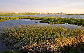
Dafeng Milu Nature Reserve is located in Dafeng, Jiangsu Province and near the Yellow Sea coast in eastern China, with the whole area 78000 ha, the core area 2668 ha, the buffer area 2220, and the experimental area 73112. The Geological landforms are typical coastal wetland, including tidal flats, seasonal stream and part of artificial wetland together with a lot of forest land, salt marsh, and bare land. The city of Dafeng belongs to subtropical and warm temperate zone, where thermophilic crops can grow well and influenced by the East Asian monsoon. The average annual temperature is 14.5 °C and the normal precipitation is over 750 mm per year.
Ntsikeni Wildlife Reserve, in Griqualand East, is the largest wetland and one of the highest above sea level in South Africa.

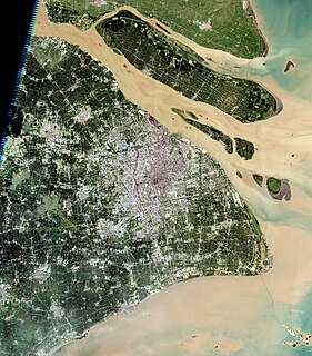
The Yellow Sea saline meadow ecoregion covers a thin strip of wetlands between the Shandong Peninsula and the mouth of the Yangtze River on the coast of the East China Sea. The plants of the region are adapted to the wet, saline soils transitioning inland to fresh water arriving from the west. The area is an important stop-over on the East Asian–Australasian Flyway. The region is under heavy ecological pressure from human development and agriculture.
