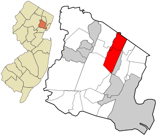
Route 21 is a highway in Northern New Jersey, running 14.35 mi (23.09 km) from the Newark Airport Interchange with U.S. Route 1/9 and U.S. Route 22 in Newark, Essex County to an interchange with U.S. Route 46 in Clifton, Passaic County. The route is a four- to six-lane divided highway known as McCarter Highway on its southern portion in Newark that serves as a connector between the Newark and Paterson areas, following the west bank of the Passaic River for much of its length. It also serves as the main north–south highway through the central part of Newark, connecting attractions in Downtown Newark with Newark Airport. The portion of Route 21 through Newark is a surface arterial that runs alongside the elevated Northeast Corridor rail line through the southern part of the city and continues north through Downtown Newark while the portion north of Downtown Newark is a freeway. Route 21 intersects many major roads including Interstate 78, Route 27, and Interstate 280 in Newark, Route 7 in Belleville, and Route 3 in Clifton.

Essex County is a county in the northeastern part of New Jersey. As of the 2019 Census estimate, the county's population was 798,975, making it the state's third-most populous county, an increase of 3.1% from the 2010 United States Census, when its population was enumerated at 783,969, in turn a decrease of 1.2% from the 793,633 enumerated in the 2000 census. In 2010, the county dropped down to third-largest, behind Middlesex County, and was one of only two counties in the state to see a decline between 2000 and 2010. Its county seat is Newark, the most populous city in the state. It is part of the New York Metropolitan Area.
Route 3 is a major state highway in the northeastern part of New Jersey, serving as the main artery to the Lincoln Tunnel from, with the help of U.S. Route 46 (US 46); together being the only main road into New York City not up to interstate highway or freeway standards, with businesses, bus stops and narrow lanes. Despite this, many construction projects over the years have been underway in effort to fix this notable issue. Route 3 also provides access to the Hoffmann La Roche American headquarters in Nutley, the Meadowlands Sports Complex and American Dream Meadowlands in East Rutherford. The road inspired a story in The New Yorker in 2004 by Ian Frazier due to its views of the Manhattan skyline.
Route 7 is a state highway in the northern part of New Jersey in the United States. It has two sections, an east–west alignment running from U.S. Route 1/9 Truck in Jersey City to Route 21 in Belleville, and a north–south alignment running from the Newark/Belleville to the Nutley/Clifton border. The New Jersey Department of Transportation (NJDOT) lists Route 7 as a single north–south highway with a small gap between the alignments. The entire highway has a combined length of 9.46 mi (15.22 km).
Montclair is a township in Essex County, New Jersey, United States. As of the 2010 United States Census, the township's population was 37,669, reflecting a decline of 1,308 (−3.4%) from the 38,977 counted in the 2000 Census, which had in turn increased by 1,248 (+3.3%) from the 37,729 counted in the 1990 Census. As of 2010, it was the 60th-most-populous municipality in New Jersey.

Nutley is a township in Essex County, New Jersey, United States. As of the 2010 United States Census, the township's population was 28,370, reflecting an increase of 1,008 (+3.7%) from the 27,362 counted in the 2000 Census, which had in turn increased by 263 (+1.0%) from the 27,099 counted in the 1990 Census.

The Passaic River is a river, approximately 80 mi (129 km) long, in northern New Jersey in the United States. The river in its upper course flows in a highly circuitous route, meandering through the swamp lowlands between the ridge hills of rural and suburban northern New Jersey, called the Great Swamp, draining much of the northern portion of the state through its tributaries. In its lower portion, it flows through the most urbanized and industrialized areas of the state, including along downtown Newark. The lower river suffered from severe pollution and industrial abandonment in the 20th century. In April 2014, the U.S. Environmental Protection Agency (EPA) announced a $1.7 billion plan to remove 4.3 million cubic yards of toxic mud from the bottom of lower eight miles (13 km) of the river. It is considered one of the most polluted stretches of water in the nation and the project one of the largest clean-ups ever undertaken.

The Watchung Mountains are a group of three long low ridges of volcanic origin, between 400 and 500 feet high, lying parallel to each other in northern New Jersey in the United States. The Watchung Mountains are known for their numerous scenic vistas overlooking New York City, Newark and New Jersey skylines, as well as their isolated ecosystems containing rare plants, endangered wildlife, rich minerals, and globally imperiled trap rock glade communities. The ridges traditionally contained the westward spread of urbanization, forming a significant geologic barrier beyond the piedmont west of the Hudson River; the town of Newark, for example, once included lands from the Hudson to the base of the mountains. Later treaties moved the boundary to the top of the mountain, to include the springs.
Hoboken, New Jersey is home to many parks, historical landmarks, and other places of interest.
The Newark Plank Road was a major artery between Hudson Waterfront at Paulus Hook and city of Newark further inland across the New Jersey Meadows. As its name suggests, a plank road was constructed of wooden planks laid side-to-side on a roadbed. Similar roads, the Bergen Point Plank Road, the Hackensack Plank Road and Paterson Plank Road, travelled to the locales for which they are named. The name is no longer used, the route having been absorbed into other streets and freeways.
County Route 507 is a county highway in the U.S. state of New Jersey. The highway extends 28.37 mi (45.66 km) from Harrison Avenue on the Kearny-Harrison town line to the New York state line in Mahwah. Between Ho-Ho-Kus and Mahwah, this highway is known as Franklin Turnpike. At its northern terminus, County Route 507 continues north into New York as Orange Avenue, which is a portion of U.S. Route 202 (US 202).
The Morris County Traction Company began trolley service in downtown Dover, New Jersey in July 1904. It was expanded over the years until the system was completed in 1914 to Newark, New Jersey. Service lasted until 1928.
The Third River, also known as the Yantecaw River, is the third (upstream) main tributary of the Passaic River in Passaic and Essex Counties, New Jersey in the United States.
The Lenape Trail is a trail through Essex County, connecting many county parks and reservations, wooded spaces, and historical sites. It begins in Newark, New Jersey and ends in Millburn, New Jersey. It was established in 1982. It is the fifth longest trail in the state behind the Delaware and Raritan Canal Trail, the Appalachian Trail, the completed section of the Highlands Trail in the state and the Batona Trail. The Lenape trail traverses Newark and its suburbs, as well as the Watchung Mountains and Passaic Meadows. Because of the steepness of the Watchung Mountains and the flood-prone nature of the Passaic Meadows, the former basin of Glacial Lake Passaic, these areas have remained much less developed than the rest of the northeastern part of the state. This trail therefore offers hikers an opportunity to see cultural and historical sites of an urban trail, as well as large natural and undeveloped areas. The trail's proximity to New York City and the various ridges it traverses, including Forest Hill, Orange Mountain, and Second Watchung Mountain, offer many views of the skyline. The Lenape Trail forms a segment of the Liberty-Water Gap Trail and incorporates the West Essex Trail, the Lenape Trail's only rail-to-trail section. The Lenape Trail also connects with Morris County's Patriots Path trail system on its western terminus.

Goffle Brook Park is a public, county park spanning much of the length of Goffle Brook through the borough of Hawthorne in Passaic County, New Jersey, United States. Since its designation and construction between 1930 and 1932, the park has served to protect the waters of Goffle Brook while at the same time providing recreational opportunities to the residents of Passaic County and nearby Bergen County. Goffle Brook Park has been included in the National Register of Historic Places since 2002.

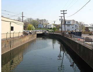
Riverbank Park is a park in the Ironbound section of Newark, Essex County, New Jersey, United States. The park was opened in 1910 and was added to the National Register of Historic Places on April 16, 1998. It is the smallest and one of the most heavily used parks in the Essex County Park System.
Yantacaw Brook is a tributary of the Third River in Essex County, New Jersey, United States. The brook rises in Montclair and then continues into the Third River in Bloomfield, New Jersey and then into Belleville and Nutley, where it enters the Passaic River. Both Yantacaw Brook and the Third River were referred to by the Lenape people as Yantokah or Yantacaw.
McDonald's Brook is tributary of the Passaic River. It is a natural stream originating in Clifton, New Jersey, passing through Passaic, New Jersey. For most of its length, it runs underground in a culvert constructed by the United States Army Corps of Engineers. Prior to the construction of the culvert, larger parts of it ran through a ground-level stream bed, though parts of it ran underground even in its natural configuration.
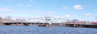
Kingsland Avenue Bridge, earlier known as Avondale Bridge and designated the De Jessa Memorial Bridge, is a vehicular movable bridge over the Passaic River in northeastern New Jersey. It crosses the county line to connect the towns of Lyndhurst in Bergen and Nutley in Essex, originally taking its name from a section of the latter. The bridge is 10.7 miles (17.2 km) from the river's mouth at Newark Bay, and is required to open on four hours' notice. As of 2010, there were 26,420 daily crossings of the bridge, which provides one lane in each direction.
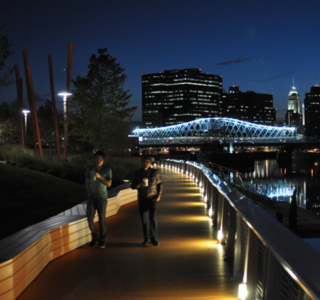
Newark Riverfront Park is a park and promenade being developed in phases along the Passaic River in Newark, New Jersey, United States. The park, expected to be 3 miles (4.8 km) long and encompass 30.5 acres (12.3 ha), is being created from brownfield sites along the river, which itself is a Superfund site due to decades of pollution. It will follow the river between the Ironbound section along Raymond Boulevard and Downtown Newark along McCarter Highway. Announced in 1999, a groundbreaking took place in 2008, and the first phase of the park opened in 2012. It was the first time residents of the largest city in New Jersey have ever had public access to the river. Other segments of the park have subsequently opened, while others are being developed. The East Coast Greenway uses paths and roads along the park.

