Srirangapatna is a town and headquarters of one of the seven Taluks of Mandya district, in the Indian State of Karnataka. It gets its name from the Ranganthaswamy temple consecrated at around 984 CE. Later, under the British rule the city was renamed to Seringapatnam. Located near the city of Mandya, it is of religious, cultural and historic importance.

Chamarajanagar or Chamarajanagara is the southernmost district in the state of Karnataka, India. It was carved out of the original larger Mysore District in 1998. Chamarajanagar town is the headquarters of this district.
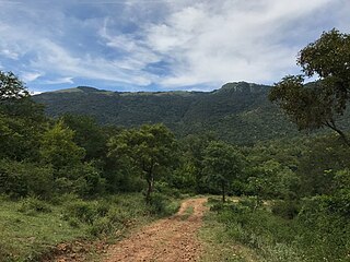
The Biligirirangana Hills or Biligirirangan Hills is a hill range situated in south-western Karnataka, at its border with Tamil Nadu in South India. The area is called Biligiri Ranganatha Swamy Temple Wildlife Sanctuary or simply BRT Wildlife Sanctuary. It is a protected reserve under the Wildlife Protection Act of 1972. Being close to the Eastern Ghats as well as the Western Ghats, the sanctuary has floral and faunal associations with both regions. The site was declared a tiger reserve in January 2011 by the Government of Karnataka, a few months after approval from India's National Tiger Conservation Authority.

Mysore district, officially Mysuru district, is an administrative district located in the southern part of the state of Karnataka, India. It is the administrative headquarters of Mysore division.Chamarajanagar District was carved out of the original larger Mysore District in the year 1998. The district is bounded by Chamrajanagar district to the southeast, Mandya district to the east and northeast, Kerala state to the south, Kodagu district to the west, and Hassan district to the north.
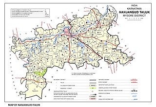
Nanjangud, officially known as Nanjanagudu, is a town in the Mysuru district of Indian state of Karnataka. Nanjangud lies on the banks of the river Kapila, 23 km from the city of Mysore. Nanjangud is famous for the Srikanteshwara Temple located here. Nanjangud is also called Dakshina Kashi. This town is also famous for a type of banana grown in the region called the Nanjanagoodu rasabale. Nanjangud's local administrative unit was designated as a Municipal Committee in 2015 by including Devirammanahalli and Kallahalli village.
Arsikere is a city and taluka in the Hassan district in the state of Karnataka, India. It is the second largest city in Hassan district, demographically. Arsikere city municipal council consists of 31 wards. This region is known for its coconut production and is also called Kalpataru Nadu. Arsikere is the taluk headquarters, a major railway junction in the South Western Railway which links Mangalore and Mysore to North Karnataka and a central place for tourists who visit nearby places that do not have rail access, such as Belur, Halebidu and Shravanabelagola, Harnahalli, and Kodimata.

Kollegal is one of the major taluks in the Chamarajanagara District of Karnataka State in the south of India. It is also the largest taluk in Karnataka, Kollegal is well known for its silk industry which attracts traders from all over the state.

Halasi is a town in Khanapur Taluk, Belgaum District in Karnataka, India. It is 14 km from Khanapur and about 25 km from Kittur. As known from inscriptions, the ancient name of the town was Palāśikā. A centre of the early Kadamba Dynasty, it was a minor capital of the Goa Kadambas (980-1025). The town is notable for a series of medieval temples. The most famous are the Varāha Narasiṃha temple and Suvarṇeśvara temple in the town, and a third temple of Rāmeśvara. On a hill about 1.9 km. south-west of the town is a pilgrimage place known as Rāmatītha.

Chamarajanagar or Chamarajanagara is a town in the southern part of Karnataka, India. Named after Chamaraja Wodeyar IX, the erstwhile king of Mysore, previously known as 'Arikottara'. Chamarajanagara is the headquarters of Chamarajanagar district. It is located on the interstate highway linking the neighboring states of Tamil Nadu and Kerala.

Tirumakudalu Narasipura the temple city of Karnataka, commonly known as T. Narasipura or T.N. Pura, is a town in Mysore district in the Indian state of Karnataka. The first name refers to the land at the confluence, (trimakuta in Sanskrit at the confluence of the Kaveri, Kabini and Spatika Sarovara.
MoodabidriMūḍubidire; also called Mudbidri, Moodbidre and Bedra), is a town and taluk in Dakshina Kannada district. It lies 34 km northeast of the district headquarters, Mangalore, in Karnataka, India.

The Ishvara temple, also referred to as the Ishwara or Isvara temple, is an early 13th-century Hindu temple in Arsikere, Hassan district, Karnataka India. Dedicated to Shiva, it is one of the most notable early Hoysala architecture examples with a rotating circular plan, a domed mandapa with 16-point star shape, a pancatala vimana, and a galaxy of artwork depicting Shaivism, Vaishnavism, Shaktism and Vedic legends of Hinduism.
Kadakola is a Town and a suburb of Mysuru metropolitan area in the southern state of Karnataka, India. It is located in the Mysore taluk of Mysore district. In November 2020, Kadakola was upgraded from a Gram Panchayat to a Town Panchayat and a gazetted notification was passed on November 26, 2020.2. The combined population of the newly formed town is 19,969.

Thandavapura is a village in the southern state of Karnataka, India. It is located in the Nanjangud taluk of Mysore district in Karnataka.

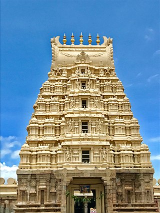
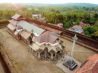
The Nanjundeshwara Temple is an ancient temple dedicated to Shiva in the Hindu pilgrimage town of Nanjanagudu in Karnataka, India. It is located on the right bank of river Kapila, a tributary of the Kaveri. Nanjangudu is also known as "Dakshina Prayaga" or "Prayag of South".

The Gaurishvara Temple is located in the town of Yelandur, Chamarajanagar district of Karnataka state, India. The temple was constructed by a local chief Singedepa Devabhupala of the Hadinadu chiefdom, a feudatory of the 16th century Vijayanagara Empire.

Kavalande is a village in Nanjangud taluk, Mysore district of Karnataka state, India.

Konanur or Paduvalamarahalli is a village in Nanjangud taluk of Mysore district, Karnataka state, India.
Estate of Yelandur or Yelandur Jagir was an estate in the erstwhile State of Mysore of Madras Presidency. At present it is located in the Chamarajanagara district in the Indian state of Karnataka..The town of Yelandur was the administrative headquarters.
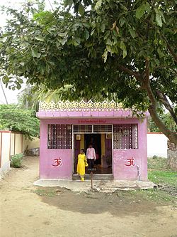
Bherya is a village located in Hosa Agrahara Hobli, Saligrama Taluk, Mysuru district of the Indian state of Karnataka. The village is a holy place, hosting 1200 year old Sri Chennakeshava temple. Now it is also famous for Doddamma and Kariyamma Temples.