Yellow River (Chippewa River tributary)

Last updated

The Yellow River in north central Wisconsin is a tributary of the Chippewa River. For the most part it is a mud and rock-bottomed river flowing through forest and farmland. It is one of four distinct rivers in the state bearing the name Yellow River.

Contents

Geography

This Yellow River begins at Matt Ochs Lake and Perch Lake in the township of Molitor near Perkinstown in the Chequamegon National Forest. [1] This area of small lakes and swamps is the terminal moraine left by the last glacier, which reached this far about 18,000 years ago. [2] The river runs a short way before it forms Chequamegon Waters Flowage, locally known as Miller Dam. Below Miller Dam, there is one more dam, at Cadott, forming another small reservoir, before the river joins the Chippewa River when it flows into Lake Wissota at Moon Bay. [3]

Much of the Yellow is undeveloped - in particular the upper stretches through the Chequamegon Forest. In very few places will you see any sign of man. The only settlements along the river are Gilman and Cadott.

History

Michel Cadotte started a trading post on the lower Yellow River at the current site of Cadott around 1787. [4]

Logging had begun on the upper Yellow by 1861, when a log-driving dam existed at Hughey. Many such log-driving dams were built to help flush logs out. [5] By 1880 a "winter road" followed the river all the way up the river to Westboro. [6] This would be a "tote road" used by logging operations to supply their crews working upstream.

Bruno Vinette, an early lumberman, tells of running a rapids on the Yellow:

I remember once when the water was very high, Gilbert and Company, on the Yellow River, needed just one crib to complete a raft and offered me twenty-five dollars to bring it down. I rigged up a couple of oars and started down alone. A lot of people stood on the bank watching to see what would happen. Instead of giving me any trouble, the crib floated like a cork. I did not have to touch the oars, and in a few minutes was safe below the falls. [7]

Recreation

In flood stage the Yellow's currents are too strong for even the most skilled of swimmers.

Chequamegon Waters, a.k.a. Miller Dam Flowage, is a man-made reservoir on the upper Yellow. Miller Dam Flowage with Canada Geese.jpg
Chequamegon Waters, a.k.a. Miller Dam Flowage, is a man-made reservoir on the upper Yellow.

Fishing in this river is some of the best in the area. The best spot is Chequamegon Waters, for bluegills, crappies, large mouth bass, northern pike, perch and the occasional walleye and smallmouth bass . The most common catch in the river is the northern pike and suckers. Wildlife abounds around the river including deer, bear, wolves, bobcat, coyote, ruffed grouse, beaver, otter, muskrat, mink, raccoon, turkey and waterfowl.

Related Research Articles

<span class="mw-page-title-main">Vilas County, Wisconsin</span> County in Wisconsin, United States

Vilas County is a county in the state of Wisconsin, United States. As of the 2020 census, the population was 23,047. Its county seat is Eagle River. The county partly overlaps the reservation of the Lac du Flambeau Band of Lake Superior Chippewa.

<span class="mw-page-title-main">Sawyer County, Wisconsin</span> County in Wisconsin, United States

Sawyer County is a county in the U.S. state of Wisconsin. As of the 2020 census, its population was 18,074. Its county seat is Hayward. The county partly overlaps with the reservation of the Lac Courte Oreilles Band of Lake Superior Chippewa Indians.

<span class="mw-page-title-main">Chippewa County, Wisconsin</span> County in Wisconsin, United States

Chippewa County is a county located in the U.S. state of Wisconsin. It is named for the historic Chippewa people, also known as the Ojibwe, who long controlled this territory. As of the 2020 census, the population was 66,297. Its county seat is Chippewa Falls. The county was founded in 1845 from Crawford County, then in the Wisconsin Territory, and organized in 1853.

<span class="mw-page-title-main">Cadott, Wisconsin</span> Village in Wisconsin, United States

Cadott is a village in Chippewa County in the U.S. state of Wisconsin. The population was 1,437 at the 2010 census.

<span class="mw-page-title-main">Cleveland, Taylor County, Wisconsin</span> Town in Wisconsin, United States

See Cleveland (disambiguation)

<span class="mw-page-title-main">Ford, Wisconsin</span> Town in Wisconsin, United States

Ford is a town in Taylor County, Wisconsin, United States. The population was 276 at the 2000 census. The unincorporated community of Polley is located in the town.

<span class="mw-page-title-main">Grover, Taylor County, Wisconsin</span> Town in Wisconsin, United States

Grover is a town in Taylor County, Wisconsin, in the United States. As of the 2010 census, the town population was 256. The unincorporated community of Perkinstown is located in the town.

<span class="mw-page-title-main">Cass Lake (Minnesota)</span> Lake in the state of Minnesota, United States

Cass Lake is a lake in north central Minnesota in the United States. It is approximately 10 mi (16 km) long and 7 mi (11 km) wide, located in Cass and Beltrami counties, within the Chippewa National Forest and the Leech Lake Indian Reservation, adjacent to its namesake city of Cass Lake. It is the 11th largest lake in Minnesota, and the 8th largest lake lying entirely within the borders of the state.

<span class="mw-page-title-main">Chequamegon–Nicolet National Forest</span> Nature preserve in northern Wisconsin, U.S.

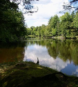
The Chequamegon–Nicolet National Forest is a 1,530,647-acre (6,194.31 km2) U.S. National Forest in northern Wisconsin in the United States. Due to logging in the early part of the 20th century, very little old growth forest remains. Some of the trees there were planted by the Civilian Conservation Corps in the 1930s. The national forest land trees and vegetation are part of the North Woods Ecoregion that prevails throughout the upper Great Lakes region.

<span class="mw-page-title-main">Jump River</span>

The Jump River is a small rocky river in north-central Wisconsin. In the late 19th century it was used to drive logs down to the Chippewa River. Today it is recreational, rambling through woods and farmlands, used mostly by fishermen and paddlers.

<span class="mw-page-title-main">Tainter Lake</span> Reservoir in Dunn County, Wisconsin

Tainter Lake is a small reservoir in north central Dunn County, Wisconsin, on the Red Cedar River at its confluence with the Hay River. The lake was created by a hydroelectric dam (about 3 miles downstream on the Red Cedar at Cedar Falls. The lake, a popular resort and fishing spot, has a surface area of approximately 2 square miles.

<span class="mw-page-title-main">Chippewa River (Wisconsin)</span> River in Wisconsin, United States

The Chippewa River in Wisconsin flows approximately 183 miles (294 km) through west-central and northwestern Wisconsin. It was once navigable for approximately 50 miles (80 km) of its length, from the Mississippi River, by Durand, northeast to Eau Claire. Its catchment defines a portion of the northern boundary of the Driftless Area. The river is easily accessible for bikers and pleasure seekers via the Chippewa River State Trail, which follows the river from Eau Claire to Durand.

<span class="mw-page-title-main">Chequamegon Bay</span> Inlet of Lake Superior in Wisconsin, USA

Chequamegon Bay is an inlet of Lake Superior in Ashland and Bayfield counties in the extreme northern part of Wisconsin.

<span class="mw-page-title-main">Madeline Island</span> Largest of the Apostle Islands in Lake Superior

Madeline Island is an island in Lake Superior. Now part of Ashland County, Wisconsin, it has long been a spiritual center of the Lake Superior Chippewa. Although the largest of the Apostle Islands, it is not included in the Apostle Islands National Lakeshore. It is the only island in the Apostle Island chain open to commercial development and private ownership.

<span class="mw-page-title-main">Lake Wissota State Park</span> State park in Chippewa County, Wisconsin

Lake Wissota State Park is a 1,062-acre (430 ha) Wisconsin state park near the town of Chippewa Falls. The park is situated on the northeast shore of Lake Wissota, a reservoir on the Chippewa River. Camping, boating, and fishing are the most popular activities. Park lands are covered in a mix of pine/hardwood forests and prairie. Visitors can access the Old Abe State Trail and bike or hike 17.5 miles (28.2 km) to Brunet Island State Park.

<span class="mw-page-title-main">Brunet Island State Park</span> State park in Chippewa County, Wisconsin

Brunet Island State Park is a state park of Wisconsin, USA, featuring a 169-acre (68 ha) island in the Chippewa River. The remainder of the park's 1,225 acres (496 ha) are on the east bank of the river. It is noted for its numerous white-tailed deer and large eastern hemlock trees. The park is located just north of Cornell in Chippewa County in the Northern Highland region of Wisconsin. The Old Abe State Trail begins in the park and follows the riverbank south to the town of Chippewa Falls, with access to Lake Wissota State Park.

Michel Cadotte, Kechemeshane in Ojibwe was a Métis fur trader of Ojibwe and French-Canadian descent. He dominated the business in the area of the south shore of Lake Superior.

<span class="mw-page-title-main">Mondeaux Dam Recreation Area</span> United States historic place

The Mondeaux Dam Recreation Area is a public park in the forest in the town of Westboro, Wisconsin, United States. The Civilian Conservation Corps (CCC) and Work Projects Administration (WPA) created the lake and facilities during the Great Depression.

Eau Claire Dam is a dam in Eau Claire County, Wisconsin, United States.

References

  1. "Surface Water Data Viewer". Wisconsin Department of Natural Resources. Retrieved 2013-03-01.
  2. Dott, Robert H. Jr; John W. Attig (2004). Roadside Geology of Wisconsin. Missoula, Montana: Mountain Press Publishing Company. pp. 106–107. ISBN   0-87842-492-X.
  3. Wisconsin Atlas and Gazetteer. Yarmouth, Maine: DeLorme. pp. 61, 73–75. ISBN   0-89933-252-8.
  4. "Cadotte Trading Post Site" . Retrieved 2013-03-01.
  5. Bundick, Ray (1960s). "Map of Taylor County drawn to accompany an article by Ray Bundick, 'The disappearance of Father Menard'" . Retrieved 2013-03-01.
  6. Dahl, Ole Rasmussen (1880). "Map of Chippewa, Price & Taylor Counties and the northern part of Clark County". The Milwaukee Litho and Engraving Company. Retrieved 2013-03-01.
  7. Vinette, Bruno; William W. Bartlett (1926). "Early Lumbering on the Chippewa". Wisconsin Magazine of History.

44°57′52″N91°18′01″W / 44.9644°N 91.3003°W / 44.9644; -91.3003