Yaa Naa Yakubu Andani II (1945–2002) was the King of Dagbon, the traditional kingdom of the Dagomba people in northern Ghana, from 31 May 1974 until his assassination on 27 March 2002. He was born in August 1945 in Sagnarigu, a suburb of Tamale in the Northern Region of Ghana. Yakubu II was killed on 27 March 2002 at Yendi, the capital of the Kingdom of Dagbon, by unknown people when clashes broke out between the two feuding Gates of Dagbon Kingship. For 600 years the Abudu and Andani clans, named after two sons of the ancient Dagbon king Ya Naa Yakubu I, cordially rotated control of the kingdom centred in Yendi, 530 kilometres (330 mi) north of Accra, the capital of Ghana. A regent acted as sovereign of the kingdom until 18 January 2019 when a new ruler is chosen to occupy the revered Lion Skins of Yendi.

The Dagbamba or Dagomba are an ethnic group of Ghana, and Togo. They number more than 3.1 million people. The term Dagbamba is originally extended to refer to other related peoples who were unified by Naa Gbewaa including the Mamprusi and Nanumba. The Dagomba country is called Dagbon and they speak Dagbanli language. Dagbanli is the most spoken language of northern Ghana and second most widely spoken local language of Ghana. Dagbanli belongs to the Mabia (Mole-Dagbani) subgroup of the Gur languages, a large group of related languages in West Africa. The Dagomba practises both patrilineal and matrilineal systems of inheritance.

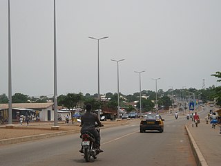
The Northern Region is one of the sixteen regions of Ghana. It is situated in the northern part of the country and ranks as the second largest of the sixteen regions. Before its division, it covered an area of 25,000 square kilometres, representing 10 percent of Ghana's area. In December 2018, the Savannah Region and North East Region were created from it. The Northern Region is divided into 16 districts. The region's capital is Tamale, Ghana's third largest city.

Salaga is a town and is the capital of East Gonja district, a district in the Savannah Region of north Ghana. Salaga had a 2012 settlement population of 25,472 people. Salaga was the largest slave market in the 18th and 19th centuries.

Savelugu-Nanton Municipal District is a former district that was located in Northern Region, Ghana. Originally created as an ordinary district assembly in 1988; which was created from the former West Dagomba District Council. It was later elevated to municipal district assembly status on 1 March 2012. However on 28 June 2012, it was split off into two new districts: Savelugu Municipal District and Nanton District. The municipality was located in the eastern part of Northern Region and had Nanton as its capital town.
Tamale Metropolitan District is one of the sixteen districts in Northern Region, Ghana. Originally created as a municipal district assembly in 1988 when it was known as Tamale Municipal District, which was created from the former West Dagomba District Council, until it was elevated to metropolitan district assembly status in August 2004. Later, a small northern part of the district was split off to create Sagnarigu District on 24 June 2012 ; thus the remaining part has been retained as Tamale Metropolitan District. The metropolis is located in the northwest part of Northern Region and has Tamale as its capital city. The metro poly is the central business hub of the region.

West Mamprusi Municipal Assembly is one of the six districts in North East Region, Ghana. Originally created as an ordinary district assembly in 1988 when it was known as West Mamprusi District, which was created from the former Mamprusi District Council, until the western part of the district was split off on 28 June 2012 to create Mamprugu-Moagduri District; thus the remaining part has been retained as West Mamprusi District. However, on 15 March 2018, it was elevated to municipal district assembly status to become West Mamprusi Municipal District. The municipality is located in the western part of North East Region and has Walewale as its capital town. Other settlements within the municipal assembly include Wulugu.
Gushegu Municipal District is one of the sixteen districts in Northern Region, Ghana. Originally it was formerly part of the then-larger Gushegu-Karaga District in 1988, which was created from the former East Dagomba District Council, until the western part of the district was split off to create Karaga District on 27 August 2004; thus the remaining part has been renamed as Gushegu District, which it was later elevated to municipal district assembly status on that same year to become Gushegu Municipal District. The municipality is located in the northeast part of Northern Region and has Gushegu as its capital town.
Karaga District is one of the sixteen districts in Northern Region, Ghana. Originally it was formerly part of the then-larger Gushegu-Karaga District in 1988, which was created from the former East Dagomba District Council, until the western part of the district was split off to create Karaga District on 27 August 2004; thus the remaining part has been renamed as Gushegu District, which it was later elevated to municipal district assembly status on that same year to become Gushegu Municipal District. The district assembly is located in the northeast part of Northern Region and has Karaga as its capital town.

Bawku Municipal District is one of the fifteen districts in Upper East Region, Ghana. Originally created as an ordinary district assembly in 1988 when it was known as Bawku East District; which was established by Legislative Instrument (L.I.) 1439, until the southern part of the district was split off by a decree of president John Agyekum Kufuor in August 2004 to create Garu-Tempane District; thus the remaining part was elevated to municipal district assembly status on the same year to become Bawku Municipal District. However, on 28 June 2012, two parts of the district were later split off to create Binduri District and Pusiga District respectively; thus the remaining part has been retained as Bawku Municipal District. The municipality is located in the eastern part of Upper East Region and has Bawku as its capital town.
Karaga is a small town and is the capital of Karaga district, a district in the Northern Region of north Ghana. It has a population of approximately 15,000. Karaga is one of the Principle Towns of the Dagbon empire. Dagbon is a name used for the Dagomba tribe. This tribe is the controlling tribe over a large area including Gushiegu, Yendi, Kpatinga, and other towns stretching from Gushiegu to the Bolga road, and bordering on Nalarigu on the north. The presiding chief is one of three or four powerful chiefs having many sub-chiefs under him. Karaga has electricity, running
water. It have about four dams and numerous boreholes which provide water for its citizens. Karaga has a hospital and clinic which can provide basic services, as well as numerous pharmacies spread throughout the town. karaga promotes peaceful activities, which include sports, cultural and entertainments. some of the sports teams are Nasara FC, Beimoni FC, Northern Lions, Bamas FC, Wumpini FC, Vision FC and Beiyom soccer ambassadors. There is a football Astro turf field for the sports activities of the district. There is also community center in the town which is adjacent to the district Hospital and not far from the market. The largest organized religion in the area is Islam, but the town also has an Assembly of God church and a Korean Missionary outreach. Animism, or ancestor worship is still widely practiced, involving witch doctors and juju-men. Sacrifice and traditional festivals are still a large part of Dagomba life. A large market gathers there every six days and provides goods, services and trade for a large area surrounding the town. Karaga has cellular phone service which provides communication and also data for web-surfing. It is the location of Dizem Bella child and maternal health center, run by Nayina Karim, one of MTN Ghana's 2016 Heroes of Change
Chereponi District is one of the six districts in North East Region, Ghana. Originally it was formerly part of the then-larger Saboba-Chereponi District in 1988, which was created from the former East Dagomba District Council, until the northern portion of the district was split off to become Chereponi District on 29 February 2008; thus the remaining part has been renamed as Saboba District. The district assembly is located in the southeast part of North East Region and has Chereponi as its capital town.
Bimbilla is the capital town of Nanumba North District, a district in the Northern Region of Ghana. It is located in the East of the region, and is near the Oti River. The location is situated within the range of 8.5° north to 9.25° north latitude, and between 0.57° east to 0.5° east longitude. It borders five municipalities: Yendi Municipal to the north, Mion Municipal to the northwest, East Gonja Municipal to the west and southwest, Nanumba South Municipal to the south and east, and Zabzugu Municipal to the north-northeast.

The Kingdom of Dagbon (Dagbaŋ) is the oldest and one of the most organised traditional kingdoms in Ghana founded by the Dagomba people (Dagbamba) in the 15th century. During its rise, it comprised, at various points, the Northern, Upper West, Upper East, Savannah Region and North East regions of present-day Ghana. It also covered portions of Burkina Faso, North East Ivory Coast and North West Togo. Since Ghana's independence in 1957, the Kingdom just like all of Ghana's kingdoms and ethnic states has assumed a traditional, customary role.
Mion District is one of the sixteen districts in Northern Region, Ghana. Originally it was formerly part of the then-larger Yendi District in 1988, which was created from the former East Dagomba District Council, until the western part of the district was later split off to create Mion District on 28 June 2012; thus the remaining original part has bee retained to become Yendi Municipal District. The district assembly is located in the central part of Northern Region and has Sang as its capital town.
Sagnarigu Municipal is one of the sixteen districts in Northern Region, Ghana. Originally it was formerly part of the then-larger Tamale Municipal District in 1988, which was created from the former West Dagomba District Council, until a small northern part of the district was split off to create Sagnarigu District on 24 June 2012; thus the remaining part has been retained as Tamale Metropolitan District. However, on 15 March 2018, it was elevated to municipal district assembly status to become Sagnarigu Municipal District. The municipality is located in the northwest part of Northern Region and has Sagnarigu as its capital city. However Tamale remains the capital city of the Northern Region.
Sang is a town in the Northern Region of north Ghana. The Mion District is one of the new districts created in 2018 in Ghana. It used to be part of the Yendi Municipal District. It is the capital of the Mion District. The largest town to the west is Tamale and to the east is Yendi.
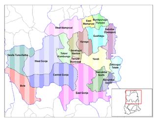
Saboba-Chereponi District is a former district that was located in Northern Region, Ghana. Originally created as an ordinary district assembly in 1988, which was created from the former East Dagomba District Council. However on 29 February 2008, it was split off into two new districts: Saboba District and Chereponi District. The district assembly was located in the northeast part of Eastern Region and had Saboba as its capital town.
West Dagomba District is a former district council that was located in Northern Region, Ghana. Originally created as an ordinary district assembly in 1975. However on 1988, it was split off into three new district assemblies: Tamale Municipal District, Savelugu-Nanton District and Tolon-Kumbungu District. The district assembly was located in the western part of Northern Region and had Tamale as its capital town.
East Dagomba District is a former district council that was located in Northern Region, Ghana. Originally created as an ordinary district assembly in 1975. However, on 1988, it was split off into four new district assemblies: Yendi Municipal District, Gushegu-Karaga District, Saboba-Chereponi District and Zabzugu-Tatale District. The district assembly was located in the eastern part of Northern Region and had Yendi as its capital town.


