
Petersville is a census-designated place (CDP) in Matanuska-Susitna Borough, Alaska, United States. It is part of the Anchorage Metropolitan Area. The population was 27 at the 2020 census.

The Susitna River is a 313-mile (504 km) long river in the Southcentral Alaska. It is the 15th largest river in the United States, ranked by average discharge volume at its mouth. The river stretches from the Susitna Glacier to Cook Inlet's Knik Arm.

Denali State Park is a 325,240-acre (131,620 ha) state park in the U.S. state of Alaska. It is located in the Matanuska-Susitna Borough adjacent to the east side of Denali National Park and Preserve, along the Parks Highway.

Hatcher Pass is a mountain pass through the southwest part of the Talkeetna Mountains, Alaska. It is named after Robert Hatcher, a prospector and miner. The nearest cities are Palmer and Wasilla approximately 12 miles (19 km) to the south, and Willow approximately 26 mi (42 km) to the west. The communities are at an elevation of approximately 250 ft (76 m) in the Mat-Su valley.

In the United States, gold mining has taken place continually since the discovery of gold at the Reed farm in North Carolina in 1799. The first documented occurrence of gold was in Virginia in 1782. Some minor gold production took place in North Carolina as early as 1793, but created no excitement. The discovery on the Reed farm in 1799 which was identified as gold in 1802 and subsequently mined marked the first commercial production.
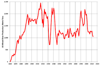
Silver mining in the United States began on a major scale with the discovery of the Comstock Lode in Nevada in 1858. The industry suffered greatly from the demonetization of silver in 1873 by the Coinage Act of 1873, known pejoratively as the "Crime of 73", but silver mining continues today.
Gold mining in Colorado, a state of the United States, has been an industry since 1858. It also played a key role in the establishment of the state of Colorado.
Silver mining in Nevada, a state of the United States, began in 1858 with the discovery of the Comstock Lode, the first major silver-mining district in the United States. Nevada calls itself the "Silver State." Nevada is the nation's second-largest producer of silver, after Alaska. In 2014 Nevada produced 10.93 million troy ounces of silver, of which 6.74 million ounces were as a byproduct of the mining of gold. The largest byproducers were the Hycroft Mine, the Phoenix Mine, the Midas Mine and Round Mountain.
Gold mining in Alaska, a state of the United States, has been a major industry and impetus for exploration and settlement since a few years after the United States acquired the territory in 1867 from the Russian Empire. Russian explorers discovered placer gold in the Kenai River in 1848, but no gold was produced. Gold mining started in 1870 from placers southeast of Juneau, Alaska.

Gold mining in Nevada, a state of the United States, is a major industry, and one of the largest sources of gold in the world. In 2018 Nevada produced 5,581,160 troy ounces, representing 78% of US gold and 5.0% of the world's production. Total gold production recorded from Nevada from 1835 to 2017 totals 205,931,000 troy ounces (6,405.2 t), worth US$322.6 billion at 2020 values. Much of Nevada's gold production comes from large open pit mining using heap leaching recovery.
The Willow Creek mining district, also known as the Independence Mine/Hatcher Pass district, is a gold-mining area in the U.S. state of Alaska. Underground hard-rock mining of gold from quartz veins accounts for most of the mineral wealth extracted from the Hatcher Pass area. The first mining efforts were placer mining of stream gravels, and placer mining in the area has continued sporadically to this day. Robert Hatcher discovered gold and staked the first claim in the Willow Creek valley in September 1906. The first lode mill in the area started operating in 1908. Underground mining continued at a variety of locations around the pass until 1951. In the 1980s one of the area's hard-rock mines was briefly re-opened. At least one mining company is actively exploring for gold in the area now. Through 2006 the district produced 667-thousand ounces of hard rock gold and 60-thousand ounces of placer gold.
The Juneau mining district is a gold mining area in the U.S. state of Alaska.
The Admiralty mining district is a mining area in the U.S. state of Alaska which consists of Admiralty Island. Silver and base metals are mined, with gold recovered as a by-product.
Recreational gold mining and prospecting has become a popular outdoor recreation in a number of countries, including New Zealand, Australia, South Africa, Wales, in Canada and in the United States especially. Recreational mining is often small-scale placer mining but has been challenged for environmental reasons. The disruption of old gold placer deposits risks the reintroduction of post gold rush pollution, including mercury in old mining deposits and mine tailings.
The South Pass greenstone belt is located within the Wyoming craton in the US. The region was the site of Wyoming's initial gold discovery in 1842.

Confederate Gulch is a steeply incised gulch or valley on the west-facing slopes of the Big Belt Mountains in the U.S. state of Montana. Its small stream drains westward into Canyon Ferry Lake, on the upper Missouri River near present-day Townsend, Montana. In 1864, Confederate soldiers on parole during the American Civil War made a minor gold discovery in the gulch, but the discovery of the sensationally rich Montana Bar the following year—one of the richest placer strikes per acre ever made—led to other rich gold strikes up and down the gulch, and touched off a frantic boom period of placer gold mining in the area that extended through 1869. From 1866 to 1869, the gulch equaled or outstripped all other mining camps in the Montana Territory in gold production, producing an estimated $19–30 million worth of gold. For a time, Confederate Gulch was the largest community in Montana. In 1866, Montana had a total population of 28,000, and of these, about 10,000 (35%) were working in Confederate Gulch.

The Juneau gold belt is located in the southeastern portion of the U.S. state of Alaska. This belt is approximately 100 miles (160 km) in length, north/northwest-trending, and extends from Berners Bay southeastward to Windham Bay, 60 miles (97 km) southeast of Juneau, and includes Douglas Island. The belt contains over 200 gold-quartz-vein deposits with production nearing 7,000,000 ounces (200,000,000 g) of gold. More than three-quarters of Alaska's lode gold was mined from the Juneau gold belt.
Bluestone River is a waterway located on the Seward Peninsula in the U.S. state of Alaska. A tributary of the Tuksuk Channel from the south, Bluestone is a north-flowing stream situated 11 miles (18 km) southeast of Teller. It was named in 1900 by Edward Chester Barnard, topographer of the United States Geological Survey.

The Independence Mines, now Independence Mine State Historic Park, is the site of a former gold mining operation in the Talkeetna Mountains, across Hatcher Pass from Palmer, Alaska. The area's mining history dates to at least 1897, when active claims were reported in the vicinity of Fishook Creek. These early mining efforts were eventually joined to form the Wasilla Mining Company, which worked the mines from 1934 to 1943, and again from 1948 to 1950. The mining operation at Independence was the second-largest hard-rock gold mining operation in the state, after a larger site near Juneau. The company and the miners that preceded it built a substantial mining camp, with as many as sixteen wood-frame buildings, which were originally connected to each other by sheltered wooden "tunnels". When the company ended operations in 1950, it had expected to eventually resume operations, but never did; this resulted in a particularly well-preserved collection of mining equipment and buildings, although the weather has since taken a significant toll on the latter.
A mining district is a special-purpose administrative subdivision used in North America. Mining districts were organized in sparsely populated, remote areas where mineral and metals mining was a viable commercial enterprise. Initially improvised as a means of self-governance for 19th-century prospectors, mining districts were eventually statutorily defined and still exist.


