Yenyening Lakes

Last updated

Yenyenning Lake
Australia Western Australia relief location map.png
Red pog.svg
Yenyenning Lake
Location in Western Australia
Location Wheatbelt, Western Australia
Coordinates 32°14′02″S117°11′54″E / 32.23389°S 117.19833°E / -32.23389; 117.19833
Type saline
Catchment area 13,000 ha (32,000 acres) [1]
Basin  countriesAustralia
Surface area150 ha (370 acres) [1]

Yenyenning Lake, also often spelt Yenyening Lakes, [1] and associated lakes [2] are in the upper Avon River catchment area in Western Australia, and the source of the Avon and Swan River systems.

It is located in the Wheatbelt region of Western Australia approximately 31 km (19 mi) north east of Brookton. [1] [3] The names of the lakes and features from the western end of the chain are: [4]

The lakes are part of what are called playa lake chains, and the system is often referred to as an example. [5]

The 13,000 ha (32,000-acre) catchment area is composed of alluvial and aeolian deposits; it receives an average annual rainfall of 452 mm (17.8 in) and has an annual evaporation rate of 2,004 mm (78.9 in). The lakes are found along major ancient drainage lines with a broad drainage floor over a paleochannel and at the meeting point of the zone of ancient drainage and the zone of rejuvenated drainage. The larger lakes in the system are separated by sandy rises, saline drainage floors and diffuse drainage lines. [1]

Situated in the Wheatbelt region, the lakes have had adjoining land heavily used for agriculture since European settlement in the region. [6] The lakes occur in three adjoining local government areas, Beverley, Brookton and Quairading. The lakes, which are a wildlife haven, were often referred to as the County Peak lakes [7] and can be seen from the summit of nearby County Peak. [8]

The resultant problems, including salinity issues, have been researched and investigated extensively. [9] [10] The location west of the lakes, where a dam was created in the early 1900s, is known as the Qualandry Crossing, and has had extensive commentary as to its effectiveness in relation to salinity issues. [11] [12]

Remnant vegetation that surrounds the lakes has been made into a nature reserve. [13]

In the early twentieth century some of the lakes had been identified as either fresh or salty [14] and in the 1970s the lakes were known for duck shooting. [15] [16]

See also

Related Research Articles

<span class="mw-page-title-main">Avon River (Western Australia)</span> River in Western Australia, Australia

The Avon River is a river in Western Australia. A tributary of the Swan River, the Avon flows 240 kilometres (150 mi) from source to mouth, with a catchment area of 125,000 square kilometres (48,000 sq mi).

<span class="mw-page-title-main">Wheatbelt (Western Australia)</span> Region of Western Australia

The Wheatbelt is one of nine regions of Western Australia defined as administrative areas for the state's regional development, and a vernacular term for the area converted to agriculture during colonisation. It partially surrounds the Perth metropolitan area, extending north from Perth to the Mid West region, and east to the Goldfields–Esperance region. It is bordered to the south by the South West and Great Southern regions, and to the west by the Indian Ocean, the Perth metropolitan area, and the Peel region. Altogether, it has an area of 154,862 square kilometres (59,793 sq mi).

<span class="mw-page-title-main">Division of O'Connor</span> Australian federal electoral division

The Division of O'Connor is an Australian electoral division in the state of Western Australia. It is one of Western Australia's three rural seats, and one of the largest electoral constituencies in the world.

County Peak, also known as Mt Quajabin or Quajabin Peak, is located in the western zone of the Wheatbelt region of Western Australia, about 120 km south-east of Perth.

<span class="mw-page-title-main">Avon Wheatbelt</span> Bioregion in Western Australia

The Avon Wheatbelt is a bioregion in Western Australia. It has an area of 9,517,104 hectares. It is considered part of the larger Southwest Australia savanna ecoregion.

Lake Magenta is an ephemeral salt lake in the Wheatbelt area of Western Australia.

Salt River is a river in the Wheatbelt region of Western Australia. It is a tributary of the Avon River, taking water from two of the Avon's sub-catchments, the Yilgarn River and the Lockhart River, from their junction where it passes through a hydrological-topographical pinch-point at Caroline Gap.

Toolibin Lake is a seasonal fresh to brackish water perched lake or wooded swamp, in south-western Australia. The lake is contained with a 493-hectare (1,218-acre) nature reserve and it is located about 200 kilometres (124 mi) south-east of Perth, in the Shire of Narrogin, and 40 kilometres (25 mi) east of the town of Narrogin, in the Wheatbelt region of Western Australia. The lake is listed by the Australian Government as a threatened ecological community under the Environment Protection and Biodiversity Conservation Act 1999.

The Brockman River is a perennial river located in the Wheatbelt region of Western Australia.

The Mackie River is a river in the Wheatbelt region of Western Australia. The river is ephemeral and flows following winter and spring rains. The water discharged is saline.

<span class="mw-page-title-main">Wheatbelt railway lines of Western Australia</span> Railway lines in the Wheatbelt region of Western Australia

The wheatbelt railway lines of Western Australia were, in most cases, a network of railway lines in Western Australia that primarily served the Wheatbelt region.

Lockhart River is a river in the Wheatbelt region of Western Australia. It is a sub-catchment of the Avon River, and has an area of 32,400 square kilometres (12,500 sq mi). At its junction with the Yilgarn River to form the Salt River, it passes through a hydrological-topographical pinch-point at 'Caroline Gap'.

<span class="mw-page-title-main">Major roads in the Wheatbelt region of Western Australia</span>

Highways and main roads in the Wheatbelt region of Western Australia form the basis of a road network, which is primarily used by the mining, agriculture, and tourism industries. Main Roads Western Australia maintains and controls these major roads, with offices based in Northam and Narrogin.

<i>Calytrix violacea</i> Species of flowering plant

Calytrix violacea is a species of flowering plant in the myrtle family, Myrtaceae and is endemic to the southwest of Western Australia. It is a shrub with linear to narrowly egg-shaped leaves with the narrower end towards the base, and purple, star-shaped flowers.

<span class="mw-page-title-main">Lake Ewlyamartup</span> Salt lake in Western Australia

Lake Ewlyamartup is an ephemeral salt lake in the Great Southern region of Western Australia located approximately 17 km (11 mi) east of the town of Katanning and about 294 km (183 mi) south east of Perth.

Coyrecup Lake is an ephemeral salt lake in the Great Southern region of Western Australia located approximately 25 km (16 mi) east of the town of Katanning and about 302 km (188 mi) south east of Perth. The lake is situated within the Coyrecup Nature Reserve, and is part of the Blackwood River drainage basin and the Hardy Estuary-Coblinine River catchment.

<span class="mw-page-title-main">Lake Towerrinning</span> Lake in Western Australia

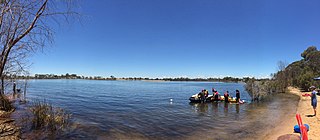
Lake Towerrinning or Towerrinning Lake is a permanent brackish lake in the Wheatbelt region of Western Australia located approximately 32 km (20 mi) south of Darkan, 44 km (27 mi) south west of Wagin and about 245 km (152 mi) south east of Perth. The lake is managed by the Department of Parks and Wildlife since it is used as a recreational facility; the Shire of West Arthur leases part of it as a gazetted water ski area.

Lake Baandee, sometimes referred to as Baandee Lake or Baandee Lakes, is an ephemeral salt lake located in the Wheatbelt region of Western Australia, approximately 8 km (5.0 mi) east of Doodlakine and 25 km (16 mi) east of Kelleberrin just off Great Eastern Highway. The town of Hines Hill is also located along the edge of the lake.

<span class="mw-page-title-main">Lake Nunijup</span> Salt lake in Western Australia

Lake Nunijup is an ephemeral salt lake located in the Great Southern region of Western Australia, approximately 27 km (17 mi) south west of Cranbrook and 41 km (25 mi) north west of Mount Barker.

Lake Yealering, also known as Yealering Lakes, is an ephemeral salt lake in the Wheatbelt region of Western Australia located on the southern edge of the town of Yealering, 30 km (19 mi) north west of Wickepin and about 250 km (160 mi) south east of Perth.

References

  1. 1 2 3 4 5 JDA Consultant Hydrologists (21 December 2011). "Living Lakes Project Stage 1: Part 1 Report Feasibility Study in the Wheatbelt and adjoining regions" (PDF). Department of Regional Development and Lands. Archived from the original (PDF) on 7 April 2019. Retrieved 9 January 2019.
  2. The saline lakes associated with Yenyenning Lake are often referred to as the Yenyenning Lakes or the Yenyenning Lake System: Western Australia. Water and Rivers Commission; Western Australia. Dept. of Conservation and Land Management; URS Australia; Yenyening Lakes Management Committee; Yenyening Lakes Management Group (2002), Yenyenning Lakes management strategy, 2002-2012, Water and Rivers Commission, retrieved 19 November 2016
  3. Anderton, P. W. F (1975), The water dynamics of the Yenyening Lakes, P. Anderton, retrieved 1 October 2020
  4. P.21 - Map 3 of https://www.water.wa.gov.au/__data/assets/pdf_file/0020/3269/13636.pdf Water Authority report Yenyening Lakes Management Strategy 2002 - 2012 -Prepared for Water and Rivers Commission and Department of Conservation & Land Management in consultation with the Yenyening Lakes Management Committee
  5. Davis, Jennifer; Carling, Paul (2012), Playa lake chains: the example of the Yenyening Lakes of the upper Avon River catchment of Western Australia, Springer, retrieved 19 November 2016
  6. Western Australia. Yenyenning Lakes Working Group; Western Australia. Dept. of Lands and Surveys; Western Australian Wildlife Research Centre (1985), Yenyenning Lakes: agricultural land aspects, Western Australian Wildlife Research Centre], retrieved 19 November 2016
  7. "Lakes "a wild life haven"". The Beverley Times . Vol. 67, no. 16. Western Australia. 5 May 1972. p. 1. Retrieved 23 October 2017 via National Library of Australia.
  8. "Tourist Road at County Peak". The Beverley Times . Vol. 62, no. 22. Western Australia. 10 June 1966. p. 1. Retrieved 23 October 2017 via National Library of Australia.
  9. Cooper, C. S (1985), Salt mitigation of the Yenyening Lakes by using a solar pond powered controlled environment salt production plant, 1985, retrieved 1 October 2020
  10. Lane, J. A. K; Western Australia. Yenyenning Lakes Working Group (1994), The Yenyenning Lakes system: a report on experimental management of outflows at Qualandary Crossing from 1985-1990 and recommendations for future management, The Group, retrieved 19 November 2016
  11. Smith, Robin A (2004), "Is the Qualandary Crossing No Dam Good?", Engineering Salinity Solutions: 1st National Salinity Engineering Conference 2004, Engineers Australia: [548]-[552], ISBN   978-0-85825-834-1
  12. Western Australia. Avon Waterways Committee; Western Australia. Water and Rivers Commission; Western Australia; Underwood, Roger (2002), River recovery plan: section 14, 15, 16 - Beverley to Qualandary Crossing, The Commission, ISBN   978-0-7309-7557-1
  13. Western Australia. Department of Conservation and Land Management; Gunness, Ann G; Bushland Plant Survey Project (W.A.); Yenyening Lakes Management Committee (W.A.) (2003), A vegetation survey of Yenyening Lakes Nature Reserve and adjoining vegetation: shires of Beverley, Brookton and Quairading for the Yenyening Lakes Management Committee, Wildflower Society of W.A, retrieved 19 November 2016
  14. "Through South Caroling". Western Mail . Vol. XXIII, no. 1, 155. Western Australia. 15 February 1908. p. 21. Retrieved 19 November 2016 via National Library of Australia.
  15. "Duck shooting season opens on Saturday". The Beverley Times . Vol. 2, no. 1. Western Australia. 8 January 1976. p. 1. Retrieved 19 November 2016 via National Library of Australia.
  16. "Aerial inspection for duck traps". The Beverley Times . Vol. 65, no. 18. Western Australia. 15 May 1970. p. 4. Retrieved 19 November 2016 via National Library of Australia.