Yilo Krobo Municipal District

Last updated
Yilo Krobo Municipal District
Municipal District
Districts of the Eastern Region (2012).svg
Districts of Eastern Region
Ghana adm location map.svg
Red pog.svg
Yilo Krobo Municipal District
Location of Yilo Krobo Municipal District within Eastern
Coordinates: 6°6′18″N0°0′57.6″W / 6.10500°N 0.016000°W / 6.10500; -0.016000
CountryFlag of Ghana.svg  Ghana
Region Flag of Eastern Region (Ghana).gif Eastern
Capital Somanya
Government
  Municipal Chief ExecutiveHon. Eric Tetteh
Area
  Total594 km2 (229 sq mi)
Population
 (2021)
  Total122,705
Time zone UTC+0 (GMT)

Yilo Krobo Municipal District is one of the thirty-three districts in Eastern Region, Ghana. [1] [2] Originally created as an ordinary district assembly in 1988 when it was known as Yilo Krobo District , which it was created from the former Kaoga District Council, until it was elevated to municipal district assembly status on 6 February 2012 to become Yilo Krobo Municipal District. The municipality is located in the eastern part of Eastern Region and has Somanya as its capital town.

Contents

Geography

Yilo Krobo Municipality is approximately between latitude 60.00’N and 00.30’N and between longitude 00.30’ and 10.00’W. It covers an estimated area of 805 km2 (311 sq mi), constituting 4.2 percent of the total area of the Eastern Region with Somanya as its capital. Yilo Krobo Municipality is bounded in the north and east by Lower Manya Krobo District, in the South by Akuapim North District and on the West by New-Juaben Municipal District, East Akim Municipal District and Fanteakwa District. [1] The municipality has about two hundred and thirty settlements out of which only the municipal capital, Somanya and Nkurakan have populations of above 5,000.  The municipality is divided into seven (7) Zonal Councils namely: Somanya, Oterkpolu, Boti, Nkurakan, Nsutapong, Klo-Agogo and Obawale

Climate

The Yilo Krobo Municipality lies within the dry equatorial climatic zone which experiences substantial amount of precipitation.  This is characterized by a bi- modal rainy season, which reaches its maximum during the two peak periods of May – June and September – October.  The annual rainfall is between 750mm in the southeast and 1600mm on the slopes of the ranges in the northwest.  Temperature ranges between a minimum of 24.90 C and a maximum of 29.90 C.  A relative humidity of 60 – 93 percent is a characteristic of the municipality.

Vegetation

The municipality lies within the semi-deciduous rain forest and the coastal savannah zone of the country.  There is the dry semi-deciduous (fire zone) which stretches from the municipality to the lower part of the Lower Manya Krobo Municipality covering 855 square kilometres.  Tree types that are most widespread in the municipality include palm, mango, nim, ceiba and acassia. The coastal savannah zone in the south-eastern part forms part of the Accra plains.

Topography and drainage

The area is predominantly mountainous.  The Akwapim Ranges stretch into the municipality from southwest to northeast across the municipality.  With its accompanying deep valleys, it provides an undulating landscape.  The low lands are in the south-eastern part of the municipality.  The rocks forming the ranges are called the Togo series, which include quartzites, phyllites, sandstones, phyllonites and sandy-shades.  The quartzites in the municipality are hard, massively bedded rocks but occasionally flaky varieties occur.  They are fine to median grained sand but grayish when fresh.  On the average, the height of the highlands in the municipality ranges between 300 and 500 metres above sea level.  There is a scarp rising up to 600 metres, which forms the boundary with the New Juaben Municipality.  On the south-eastern part of the municipality is the Krobo Mountains from where it is believed the Yilo people migrated to the present area

Population size and distribution

According to the 2010 Population and Housing Census (PHC) report, Yilo Krobo has a total population of 87,847 which comprises 42,378 males (48.2%) and 45,469 females (54.8%); depicting more females than males. This represents 3.3 percent of the regional population. With a growth rate (crude) of about 1.25%, the municipality's population stood at 91,183 as at the end of 2013.

About 30.92 percent of the population lives in urban centres whilst 69.8 percent lives in rural areas. This might be because the municipality is more rural than urban. For all groups of ages, most people are living in the rural areas as compared to the urban areas. This could be due to the fact that the main occupation in the municipality is farming. The municipality must therefore fashion out strategies to development the agricultural sector and growth of other settlements. Table 1.8 shows the population size by locality of residence, the sex ratio and the percentage the municipality covers in the region.

Sex ratio is the ratio of males to females in a given population, usually expressed as the number of males per 100 females. The sex ratio for Yilo Krobo Municipality is 93.20 meaning there are about 93 males, for every 100 females.

Migration

The total number of migrants in Yilo Krobo Municipality was 27,474 (2010 PHC). Out of this, about 69 percent which is equivalent to 19,045 persons were born in the same region but leaving elsewhere other than their place of birth in that same region (intra-regional migration). The Volta, Greater Accra and Ashanti regions are relatively large in-migrant areas in the municipality, i.e., 2,429, 1,931 and 1,188 persons respectively. The Greater Accra and Volta regions are very close to the municipality and this might explain why people easily move from those regions to the municipality to trade. The least in-migrant areas are Upper East and Upper West regions i.e. 77 and 57 persons respectively. This might also be due to the fact that these regions are the farthest from the municipality so very few migrants move from those places to the municipality to trade. Those who migrate might do so because of marriage since Upper East had the highest percentage (29.9) of persons who have stayed in the municipality for twenty years and above.

Household Size

The total number of households in the Yilo Krobo Municipality is 20,613. Out of this, 13,145 households are headed by males and the remaining 7, 468 by females. As the number of household size increases, the number of persons constituting such households decreases. Few persons have household sizes of 8 and above. The average household size for the Yilo Krobo municipality is 4.2. This means that on the average each household in the municipality is made up of 4 persons. It is interesting to note that the average household size of male headed households is about 3 (3.2) while that of the female is 6.0 which is almost twice that of the males. This might be due to the fact that most of the time when females head a household; they bring their relatives and family friends to stay with them. This in turn increases the number of persons living in the household

Sources

Related Research Articles

Demographics of Ghana Overview of Ghanas population

The Demography of Ghana describes the condition and overview of Ghana's population. This article is about the demographic features of the population of Ghana, including population density, ethnicity, education level, health of the populace, religious affiliations, and other aspects of the population.

Hodh Ech Chargui Region Region of Mauritania

Hodh Ech Chargui is a large region in eastern Mauritania, with an area of 182,700 km2. Its capital is Néma, but the largest town, in Bassiknou Department, is Fassala at the extreme southeast of Mauritania, with 65,927 inhabitants at the 2013 census. The region borders the Mauritanian regions of Adrar, Tagant and Hodh El Gharbi to the west and Mali to the east and south. The Aoukar basin, which formerly gave name to a greater region, is located in the western part of Hodh Ech Chargui.

The Dangbe language, also Dangbe or Adaŋgbi, is a Kwa language spoken in south-eastern Ghana by the Dangbe People (Dangbeli). The Dangbeli are part of the larger Ga-Dangbe ethnic group. Klogbi is a variant, spoken by the Kloli. Kropp Dakubu (1987) is the most thorough grammar of the language.

Eastern Region (Ghana) Region of Ghana

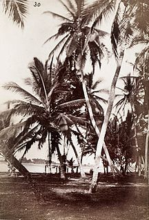
The Eastern Region is located in south Ghana and is one of the sixteen administrative regions of Ghana. Eastern region is bordered to the east by the Lake Volta, to the north by Bono East Region and Ashanti region, to the west by Ashanti region, to the south by Central region and Greater Accra Region. Akans are the dominant inhabitants and natives of Eastern region and Akan, Ewe, Krobo, Hausa and English are the main spoken languages. The capital town of Eastern Region is Koforidua.The Eastern region is the location of the Akosombo dam and the economy of the Eastern region is dominated by its high-capacity electricity generation. Eastern region covers an area of 19,323 square kilometres, which is about 8.1% of Ghana's total landform.

Koforidua City in Eastern Region, Ghana

Koforidua, also popularly known as K-dua or Kofcity, is a city and the capital of Eastern Region in southern Ghana. Koforidua was founded in 1875 by migrants from Ashanti. It is also called New Juaben. The city has a settlement city proper population of 183,727 people as of 2010, Koforidua is an amalgamation of two Municipalities; New Juaben North and South. The city has a blend of colonial and modern architecture.

Accra Metropolitan District City and Metropolitan District in Ghana

The Accra Metropolitan District is one of the 254 Metropolitan, Municipal and Districts in Ghana, and among the 26 such districts in the Greater Accra Region with a population of 284,124 as of 2021. As of March 2018, it spans an area of approximately 60 km2 (23 sq mi) and encompasses the Ablekuma South, Ashiedu Keteke, and Okaikoi South sub-metropolitan district councils.

Manya Krobo District Former District in Ghana

Manya Krobo District is a former district that was located in Eastern Region, Ghana. Originally created as an ordinary district assembly in 1988, which was created from the former Kaoga District Council. However on 29 February 2008, it was split off into two new districts: Lower Manya Krobo District and Upper Manya Krobo District. The district assembly was located in the eastern part of Eastern Region and had Odumase as its capital town.

Somanya is a town and the capital of Yilo Krobo District, a district in the Eastern Region of south Ghana. Somanya has a 2013 settlement population of 20,596 people. Because the town is surrounded by a number of farming communities to the north of it, the name Somanya is used to encompass a collection of smaller communities around a bigger one. As a result, the 2010 Population and Housing Census conducted by the Government of Ghana put the population of Somanya at 87,847, representing 3.3% of the region's total population. Males constitute 48.2 percent of the population while females represent 51.8 percent, according to the Ghana Census Bureau. The entire Krobo district is described as rural, and Somanya is the municipal district center of the surrounding smaller towns. With the capital of Ghana, Accra, rapidly expanding northwards, the traveling distance between Somanya and Accra is shrinking and now is around 30 miles (48 km). The temperatures are highest on average in March, at around 28.4 °C. At 25.1 °C on average, August is the coldest month of the year.

Alexander Narh Tettey-Enyo is an educationist and politician. He has been the Member of Parliament for Ada since 2005 and the Ghanaian Minister for Education between 2009 and 2011.

Ghana Health Service

The Ghana Health Service (GHS) is a Ghanaian government body established in 1996 as part of the Health Sector Reform of Ghana. The Health Service is under the Ministry of Health. The Health service primarily administrates the health services provided by the government and in implementing government policies on healthcare. The Director-General of the Health service is Dr. Patrick Kuma-Aboagye.

Ledzokuku-Krowor Municipal District Former Municipal District in Ghana

Ledzokuku-Krowor Municipal District is a former district that was located in Greater Accra Region, Ghana. Originally it was formerly part of Accra Metropolitan District in 1988, until the far eastern portion of the district was split off to create Ledzokuku-Krowor Municipal District on 1 November 2007 ; thus the remaining part has been retained as Accra Metropolitan District. However on 15 March 2018, it was split off into two new municipal districts: Ledzokuku Municipal District and Krowor Municipal District. The municipality was located in the central part of Greater Accra Region and had Teshie-Nungua as its capital town.

Lower Manya Krobo Municipal District Municipal District in Ghana

Lower Manya Krobo Municipal District is one of the thirty-three districts in Eastern Region, Ghana. Originally it was formerly part of the then-larger Manya Krobo District in 1988, which was created from the former Kaoga District Council, until the northwest part of the district was split off to create Upper Manya Krobo District on 29 February 2008; thus the remaining part has been renamed as Lower Manya Krobo District. It was later elevated to municipal district assembly status on 6 February 2012 to become Lower Manya Krobo Municipal District. The municipality is located in the eastern part of Eastern Region and has Odumase as its capital town.

Old Ningo Place in Greater Accra Region, Ghana

Old Ningo is a town in the Greater Accra Region of Ghana.

Boti falls Pair of waterfalls in Ghana

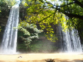
Boti falls is a twin waterfall located at Boti in Yilo Krobo District in the Eastern Region of Ghana. These twin falls are referred to as female and male.

Mount Mary College of Education is a teacher education college in Somanya. The college is located in Eastern / Greater Accra zone. It is one of the 46 public Colleges of Education in Ghana. The college participated in the DFID-funded T-TEL programme.

Oklemekuku, Nene Azzu Mate Kole II,, known in private life as Frederick Lawer Mate Kole was a Ghanaian paramount chief and politician who served as the fourth monarch or king, Konor of the Manya Krobo Traditional Area in southeastern Ghana and reigned from 1939 to 1990.

Emmanuel Humphrey Tettey Korboe was a Ghanaian politician in the first republic. He served as a regional commissioner for the Eastern Region and later for the Central Region. He also served as a member of parliament for the Yilo-Krobo constituency and later the Somanya constituency.

Kaoga District Former District Council in Ghana

Kaoga District is a former district council that was located in Eastern Region, Ghana. Originally created as an ordinary district assembly in 1975. However on 10 March 1989, it was split off into three new district assemblies: Yilo Krobo District, Manya Krobo District and Asuogyaman District. The district assembly was located in the eastern part of Eastern Region and had Somanya as its capital town.

Okperpiem is a suburb of Somanya in the Yilo Krobo municipality in the Eastern region of Ghana.

References

  1. 1 2 Yilo Krobo Municipal District
  2. "Malaria is endemic in most communities – Deputy Public Health Director". Citinewsroom - Comprehensive News in Ghana. 2021-05-20. Retrieved 2021-05-20.

Coordinates: 6°6′18″N0°0′57.6″W / 6.10500°N 0.016000°W / 6.10500; -0.016000