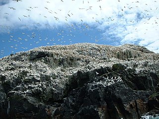
Grassholm or Grassholm Island is a small uninhabited island situated 13 kilometres (8 mi) off the southwestern Pembrokeshire coast in Wales, lying west of Skomer, in the community of Marloes and St Brides. It is the westernmost point in Wales other than the isolated rocks on which the Smalls Lighthouse stands. Grassholm is known for its huge colony of northern gannets; the island has been owned since 1947 by the Royal Society for the Protection of Birds, and is one of its oldest reserves. It reaches 42 metres (138 ft).

Ramsey Island is an island about 1 kilometre off St David's Head in Pembrokeshire on the northern side of St Brides Bay, in southwest Wales, in the community of St Davids and the Cathedral Close. It is 259 hectares in area. Ramsey means Hrafn's island.

Saint Tudwal's Islands are a small archipelago lying south of Abersoch on the Llŷn Peninsula in North Wales, at the western end of Tremadog Bay. They were referred to as the Studwells in the early 19th century. The name of the islands derives from their traditional identification as the site of a hermitage used by Saint Tudwal during the 6th century. They are about 1 kilometre (0.6 mi) east of the southern tip of the Llŷn Peninsula.

Middle Mouse is an uninhabited island situated 1 kilometre off the north coast of Anglesey. It is notable as the northernmost point of Wales. The island measures a maximum of 207 metres by 110 metres, with a maximum area of 3.7 acres and has a maximum altitude of 16 metres (52') above sea level. It is one of a chain of three islands off the north of Anglesey, the others being Ynys Amlwch and Maen y Bugail.

West Mouse is an islet lying 1.1 kilometres (0.68 mi) off the north-west coast of Anglesey, Wales. Its maximum dimensions are 92 by 82 metres, with an area of 1.2 acres (4,900 m2).

Burry Holms, a tidal island with the height of is at the northern end of Rhossili Bay in the Gower Peninsula, Wales. During spring and summer, Burry Holms is covered by flowers such as thrift and sea campion.
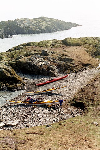
Ynys Bery is a small island south of Ramsey Island, Pembrokeshire, Wales, in the community of St David's and the Cathedral Close.
The Skerries, coming from the Old Norse word sker, are a group of sparsely vegetated rocky islets (skerries), with a total area of about 17 hectares lying 3 kilometres (1.9 mi) offshore from Carmel Head at the northwest corner of Anglesey, Wales. The islands are important as a breeding site for seabirds, and they attract divers, who come to visit the numerous shipwrecks. The Skerries Lighthouse sits atop the highest point in the islands.
Ynys Feurig is the name for a set of three small inter-connected low-lying inshore tidal rocky islets, lying off from the west coast of Anglesey, North Wales, just north of the village of Rhosneigr and south of RAF Valley airfield. They are also known by the English name Starvation Island. The islets are accessible from the mainland at mid-to low tide. The clipper Norman Court ran aground nearby, in Cymyran Bay.

Puffin Island is an uninhabited island off the eastern tip of Anglesey, Wales. It was formerly known as Priestholm in English. A hermitage was established here around the 6th century, and there are remains of a 12th-century monastery on the island. The island is also a Special Protection Area for wildlife.

The Swellies is a stretch of the Menai Strait in North Wales. The most popular use of the name is for the stretch between the Britannia Bridge and the Menai Bridge.

Ynys Castell is a small island in the Menai Strait which separates Anglesey and mainland Wales. It is an extruding piece of Precambrian schist lying to one side of the Afon Cadnant estuary. It lies between Ynys y Bîg and Ynys Gaint. There is a causeway running to the island that is covered at high tide. On the island there is a private house. Ynys Castell means Castle Island in Welsh.

Ynys Gaint is a small island in the Menai Strait connected to the town of Menai Bridge on Anglesey by a causeway and also a concrete bridge erected by Sir William Fison in the 1930s. Literally translated Ynys Gaint mean Kent Island.
Church Island, also known as Llandysilio Island, is a small island in the Menai Strait on the shores of Anglesey to which it is attached by a short causeway that is reachable only on foot. The dominant feature of the island is with St Tysilio's Church, constructed in the 15th century, its churchyard, and a grade-II listed war memorial. The 20th-century bard Cynan is among several notable people buried in the churchyard. The Anglesey Coastal Path passes the head of the causeway.
Dulas Bay is a small bay on the north east coast of Anglesey, north Wales, forming the boundary between Llaneilian and Moelfre communities. The bay is bordered by three beaches.
Ynys Dulas is a small island located off the north-east coast of Anglesey, Wales. It marks the most eastern part of the parish of Llaneilian.
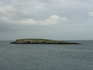
Ynys Moelfre is a small island off the coast of Anglesey, Wales. At low tide it has a maximum length of 261 metres and a maximum width of 121 metres with a maximum area of 6.6 acres (27,000 m2). The nearest settlement to the island is the village of Moelfre, and the two are separated by a shallow channel called Y Swnt, which is never more than 194 metres wide and can at low tide only be waist-deep all the way across. At extreme low Spring tides, it is possible to walk across to the island on dry ground all the way. Due to its proximity to the mainland there are grasses found on the island and a few wild flowers. Species of birds that can be found on the island include gulls, terns, gannets, fulmars, and Great/Arctic skuas. A colony of seals live there and porpoises are occasionally seen also. There are, however, no man-made structures. It is referred to by some locals as Rat Island.

East Mouse is an islet found off the north coast of Anglesey, Wales. It is found just a few hundred metres away from the town of Amlwch. For this reason the island is known in Welsh as Ynys Amlwch, Amlwch Island. The islet is tiny with a maximum area of only 1.5 acres (6,100 m2), and void of any significant flora and fauna. The islet is one of three similarly named islands off the north coast of Anglesey, the other two being West Mouse and Middle Mouse. The island is the site of the wreck of the SS Dakota, which was built in 1874, striking the island and sinking on 9 May 1877. The 4,332-ton ship was broken into three pieces but all 218 souls on board were saved.
The Afon Alaw is a river on Anglesey in Wales which rises near Llanerch-y-medd and flows northwards into the reservoir of Llyn Alaw. Below the dam it then flows southwestwards to the island's west coast near Llanfachraeth. Its lower reaches, west of the A5025 road, are tidal.
