Scotland Yard is the headquarters of the Metropolitan Police, the territorial police force responsible for policing the 32 boroughs of London. Its name derives from the location of the original Metropolitan Police headquarters at 4 Whitehall Place, which also had an entrance on a street called Great Scotland Yard. The Scotland Yard entrance became the public entrance to the police station, and over time the street and the Metropolitan Police became synonymous. The New York Times wrote in 1964 that, just as Wall Street gave its name to New York's financial district, Scotland Yard became the name for police activity in London.

The Bakerloo line is a London Underground line that goes from Harrow & Wealdstone in suburban north-west London to Elephant & Castle in south London, via the West End. Printed in brown on the Tube map, it serves 25 stations, 15 of which are underground, over 14.4 miles (23.2 km). It runs partly on the surface and partly in deep-level tube tunnels.

The Piccadilly line is a deep-level London Underground line running from the north to the west of London. It has two branches, which split at Acton Town, and serves 53 stations. The line serves Heathrow Airport, and some of its stations are near tourist attractions such as Piccadilly Circus and Buckingham Palace. The District and Metropolitan lines share some sections of track with the Piccadilly line. Printed in dark blue on the Tube map, it is the fourth busiest line on the Underground network, with over 210 million passenger journeys in 2011/12.

Waterloo is a London Underground station located beneath Waterloo National Rail station. As of 2021, it is the 5th busiest station on the London Underground, with 29.87 million users. It is served by four lines: the Bakerloo, Jubilee, Northern and Waterloo & City lines.

Waterloo Bridge is a road and foot traffic bridge crossing the River Thames in London, between Blackfriars Bridge and Hungerford Bridge and Golden Jubilee Bridges. Its name commemorates the victory of the British, Dutch and Prussians at the Battle of Waterloo in 1815. Thanks to its location at a strategic bend in the river, the bridge offers good views of Westminster, the South Bank and the London Eye to the west, and of the City of London and Canary Wharf to the east.
The Shell Centre, in London, is the global headquarters of oil major Shell plc. It is located on Belvedere Road in the London Borough of Lambeth. It is a prominent feature on the South Bank of the River Thames near County Hall, and now forms the backdrop to the London Eye.

Victoria Embankment is part of the Thames Embankment, a road and river-walk along the north bank of the River Thames in London. It runs from the Palace of Westminster to Blackfriars Bridge in the City of London, and acts as a major thoroughfare for road traffic between the City of Westminster and the City of London
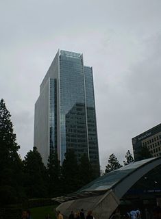
10 Upper Bank Street is a 32-story commercial skyscraper located in Canary Wharf, in the Docklands area of London. It was completed in 2003 and is 151 m (495 ft) tall.
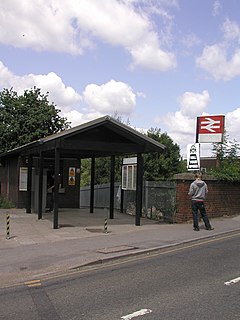
Winnersh railway station, previously known as Sindlesham and Hurst Halt and then Winnersh Halt, is a railway station located in the centre of the village of Winnersh in Berkshire, England. It is served by South Western Railway services between London Waterloo and Reading. The station is 38 miles 53 chains (62.2 km) from London Waterloo and 7.7 kilometres (4.8 mi) from Reading, at the point where the B3030 road crosses the line on an overbridge.

Waterloo Road is the main road in the Waterloo district of London, England straddling the boroughs of Lambeth and Southwark. It runs between Westminster Bridge Road close to St George's Circus at the south-east end and Waterloo Bridge across the River Thames towards London's West End district at the north-west end.

North Pole depot is a railway and maintenance depot built for Great Western Railway's AT300 units from the Hitachi A-train family. Located in the London Borough of Hammersmith and Fulham, the depot was partially redeveloped by Agility Trains from 2013 as a maintenance site when they were awarded the Intercity Express Programme.
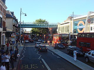
Brixton Road is a road in the London Borough of Lambeth, leading from the Oval at Kennington to Brixton, where it forms the high street and then forks into Effra Road and Brixton Hill at St Matthew's church at the junction with Acre Lane and Coldharbour Lane. Brixton Market is located in Electric Avenue near Brixton Underground station and in a network of covered arcades adjacent to the two railway viaducts. The market arcades were declared listed buildings in 2009 following controversial proposals by Lambeth Council to replace them with a large US-style mall. The former "Brixton Oval" is at the southern end with Lambeth Town Hall, the Ritzy Cinema, the Brixton Tate Library and St Matthew's church. The space was renamed Windrush Square in 2010, in honour of the area's early Caribbean migrants and the HMT Empire Windrush, which in 1948 brought 492 passengers from Jamaica to London.
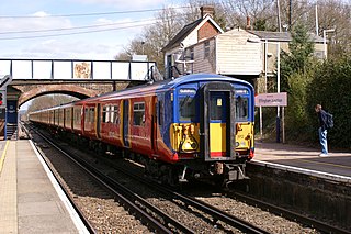
Effingham Junction railway station is just north of the far northern border of the village of Effingham, closer to the centre of East Horsley, homes of which it borders, in Surrey, England. Although the station takes its name from the former settlement, and the immediate vicinity has itself become known as Effingham Junction, it is actually in the latter. Effingham Junction is at the junction of the New Guildford Line, from London Waterloo to Guildford, and the line from Leatherhead, which carries trains from Waterloo via Epsom. It is 21 miles 10 chains (34.0 km) down the line from Waterloo.

The General Lying-In Hospital was one of the first maternity hospitals in Great Britain. It opened in 1767 on Westminster Bridge Road, London and closed in 1971. Lying-in is an archaic term for childbirth.

Verulam House is located in Verulam Road, St Albans on the northwestern side between Church Crescent and Britton Avenue opposite College Street. It has previously been referred to as Diocesan House and also known as the Bishop's Palace. It is of early nineteenth-century origin and is a Grade II Listed Building.
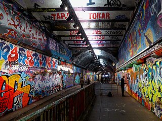
Leake Street is a road tunnel in Lambeth, London where graffiti is tolerated regardless of the fact that it is against the law. The street is about 300 metres long, runs off York Road and under the platforms and tracks of Waterloo station.
The metropolitan area of London, England, United Kingdom, is served by six international airports and several smaller airports. Together, they make the busiest airport system in the world by passenger numbers and the second-busiest by aircraft movements. In 2018, the six airports handled a total of 177,054,819 passengers. The London airports handle over 60% of all the UK's air traffic. The airports serve a total of 14 domestic destinations and 396 international destinations.

St Matthew's Church is a Church of England church in the London Borough of Lambeth. It is a Grade II* listed building which occupies a prominent position at the junction of Brixton Road, Brixton Hill and Effra Road. The church was constructed following the Church Building Act 1818 and was consecrated in 1824.
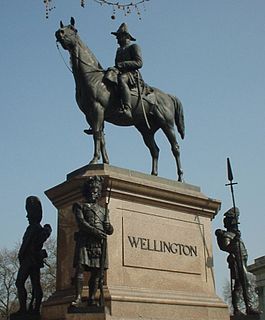
An equestrian statue of the Duke of Wellington stands on the north side of Hyde Park Corner, London. The open space in which it stands, now the centre of a large roundabout, was once called Wellington Place.

New Scotland Yard, formerly known as the Curtis Green Building and before that as Whitehall Police Station, is a building in Westminster, London. Since November 2016, it has been the Scotland Yard headquarters of the Metropolitan Police Service (MPS), the fourth such premises since the force's foundation in 1829. It is located on the Victoria Embankment and is situated within the Whitehall Conservation Area. It neighbours the Norman Shaw and Ministry of Defence buildings, together with Richmond House and Portcullis House.