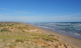
The Coorong National Park is a protected area located in South Australia about 156 kilometres (97 mi) southeast of Adelaide and that predominantly covers a lagoon ecosystem officially known as the Coorong and the Younghusband Peninsula on the Coorong's southern side.

Lake Alexandrina is a coastal freshwater lake located between the Fleurieu and Kangaroo Island and Murray and Mallee regions of South Australia, about 100 kilometres (62 mi) south-east of Adelaide. The lake adjoins the smaller Lake Albert and a coastal lagoon called The Coorong to its southeast, before draining into the Great Australian Bight via a short, narrow opening known as Murray Mouth.

Lake Albert, also known by its Ngarrindjeri name, Yarli, is a notionally fresh water lake near the mouth of the Murray River in South Australia. It is filled by water flowing in from the larger Lake Alexandrina at its mouth near Narrung. It is separated on the south by the Narrung Peninsula from the salt-water Coorong. The only major town on the lake is Meningie. Lakes Alexandrina and Albert are together known as the Lower Lakes.
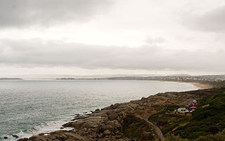
Encounter Bay, once known as Ramong to the Ramindjeri people, is a bay in the Australian state of South Australia located on the state's south central coast about 100 kilometres (62 mi) south of the state capital of Adelaide. It was named by Matthew Flinders after his encounter on 8 April 1802 with Nicolas Baudin, the commander of the Baudin expedition of 1800–03. It is the site of both the mouth of the River Murray and the regional city of Victor Harbor. It is one of four "historic bays" located on the South Australian coast.

Murray Mouth is the point at which the River Murray meets the Southern Ocean. The Murray Mouth's location is changeable. Historical records show that the channel out to sea moves along the sand dunes over time. At times of greater river flow and rough seas, the two bodies of water would erode the sand dunes to create a new channel leaving the old one to silt and disappear.

Coorong is a locality in the Australian state of South Australia which is associated with the lagoon known as the Coorong in the south-east of the state and which overlooks the continental coastline from the mouth of the Murray River about 80 kilometres south-east of the state capital of Adelaide to the immediate north of the town of Kingston SE extending for a distance of at least 140 kilometres (87 mi).

Plebidonax deltoides or Donax deltoides is a small, edible saltwater clam or marine bivalve mollusc, endemic to Australia. It belongs to the family of either the Donacidae, or the related Psammobiidae. It is most widely known as the pipi in the eastern states of its native Australia. In South Australia, it is called the Coorong cockle, Goolwa cockle, or Goolwa pipi, for the region where it is most abundant, or by its Ngarrindjeri name, kuti. In south-eastern Queensland, it is often also known as eugarie or (y)ugari, a borrowing from the local Yugambeh and Ugarapul languages.
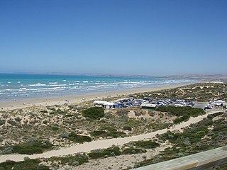
Sir Richard Peninsula is a narrow peninsula consisting of sand which extends from Goolwa, South Australia to the Murray Mouth. It separates the Goolwa Channel, which is part of the estuary of the River Murray, from Encounter Bay. It is approximately 10 kilometres (6.2 mi) in length and ranges from 500 metres (1,600 ft)to 1 kilometre (0.62 mi) in width. The peninsula, together with the Younghusband Peninsula on the eastern side of the Murray Mouth, is the primary sand dune line defining this stretch of the Australian coastline.

Nepean Bay is a bay located on the north-east coast of Kangaroo Island in the Australian state of South Australia about 130 kilometres south-south-west of Adelaide. It was named by the British navigator, Matthew Flinders, after Sir Evan Nepean on 21 March 1802.

Pondalowie Bay is a bay in the Australian state of South Australia located on the west coast of the south-west tip of Yorke Peninsula in Spencer Gulf about 12 kilometres west of Marion Bay. The coastline of Pondalowie Bay is both within the gazetted locality of Inneston and the Innes National Park.

Warburto Point is a headland located on the west coast of the Yorke Peninsula in South Australia about 12 kilometres south west of the town of Wallaroo. The point is described by one source as being ‘a rocky projection that extends about 1.5 nautical miles W(est) from the mainland’ and that ‘it is 6.1 metres high and is fringed by mangroves along each of its sides.’ The land at the tip of the point has been part of the Bird Islands Conservation Park since 1972. Since 1995, it has been the site of a navigation aid in the form of a light tower which was commissioned to replace the lighthouse on Tiparra Reef. It is also the site of a coastal weather station operated by the Australian Bureau of Meteorology.
West Cape is a headland located on the west coast of the Yorke Peninsula in South Australia in the gazetted locality of Inneston about 14 kilometres west of the town of Marion Bay. It is the most westerly point of Yorke Peninsula. Since 1970, the headland has been located within the Innes National Park while the waters adjoining its shoreline have been located within the Southern Spencer Gulf Marine Park since 2012. Since 1980, it has been the site of a navigation aid in the form of a lighthouse.

Corny Point is a headland located on the west coast of the Yorke Peninsula in South Australia about 37 kilometres north west of the town of Warooka. The point is described as being "a sloping rocky double projection..." where the "coast on the N[orth] side is low and sandy whereas the coast on the S[outh] side is higher than the point itself." It is the south headland of Hardwicke Bay. It was named by Matthew Flinders on 18 March 1802. The waters adjoining its shoreline are within the Southern Spencer Gulf Marine Park. Since 1882, it has been the site of a navigation aid in the form of a lighthouse.
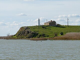
Mud Islands Game Reserve is a protected area in South Australia covering ten islands at the southern side of Lake Alexandrina about 19 kilometres south-east of Goolwa. The game reserve is described as providing ‘an ideal habitat for water birds, particularly waterfowl’ and that ‘duck shooting is permitted during open season.’ Since 2000, the game reserve has been located within the boundaries of the gazetted locality, Coorong.
Chowilla Game Reserve is a protected area covering the floodplain on the north side of the River Murray in South Australia from about 8 kilometres north-east of Renmark to the New South Wales border. It was proclaimed 8 April 1993 in conjunction with the Chowilla Regional Reserve. Its creation arises from a community consultation process which recommended that ‘hunting of waterfowl be a permitted activity in selected areas of the Chowilla floodplain’. The game reserve is classified as an IUCN Category VI protected area.

Greenly Island Conservation Park is a protected area associated with Greenly Island located off the west coast of Eyre Peninsula in South Australia about 70 kilometres west of Coffin Bay. It was declared in 1972 under the National Parks and Wildlife Act 1972 ‘to protect the island’s delicate ecology and Australian Sea-lion and New Zealand Fur-seal haul-out areas’ and continuing protected area status for the island which was first declared in 1919. The conservation park is classified as an IUCN Category Ia protected area.
Poltalloch is a locality in the Australian state of South Australia located on land between the water bodies of Lake Alexandrina and Lake Albert about 87 kilometres south-east of the state capital of Adelaide.
Mundoo Island is a locality in the Australian state of South Australia located on Mundoo Island and some adjoining water at the southern end of Lake Alexandrina about 87 kilometres (54 mi) south-east of the state capital of Adelaide.
Ramco Point Conservation Park is a protected area located in the Australian state of South Australia in the locality of Sunlands about 150 kilometres (93 mi) north-east of the state capital of Adelaide and about 7 kilometres (4.3 mi) north-west of the municipal seat of Waikerie.