
Bole, also known by its Mongolian name Bortala, is a county-level city in Xinjiang, China. It is the seat of Bortala Mongol Autonomous Prefecture, which borders Kazakhstan. The city covers an area of 7,517 square kilometres (2,902 sq mi) and has a total population of 270,000 as of 2015. The Northern Xinjiang Railway runs through the city, as do highways to Ürümqi.

Qapqal Xibe Autonomous County in Ili Kazakh Autonomous Prefecture in Northern Xinjiang, is the only Xibe autonomous county of China, bordering Kazakhstan's Almaty Region to the west. It has an area of 4,430 square kilometers and a population 160,000 (2000). Qapqal means "the granary" in the Xibe language.
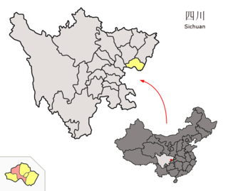
Yuechi County is a county in the east of Sichuan province, China, bordering Chongqing Municipality to the south. It is administratively governed by the prefecture-level city of Guang'an.
Habahe County as the official romanized name, also transliterated from Uyghur as Kaba County, is a county situated in the far north of the Xinjiang Uyghur Autonomous Region and is under the administration of the Altay Prefecture. It has an area of 8,179 km2 (3,158 sq mi) with a population of 80,000. The Postcode is 836700.

Jeminay County or Jimunai County, is a county situated in the north of the Xinjiang Uyghur Autonomous Region and is under the administration of the Altay Prefecture.

Shawan, also transliterated from Chinese to Uyghur as Savan, is a county-level city situated in the north of the Xinjiang Uyghur Autonomous Region under the administration of the Tacheng Prefecture. It has an area of 12,468 km2 (4,814 sq mi) with a population of 200,000. The Postcode is 832100.

Toli County is a county situated in the north of the Xinjiang Uyghur Autonomous Region and is under the administration of the Tacheng Prefecture. It has an area of 19,982 km2 (7,715 sq mi) with a population of 90,000. The Postcode is 834500.

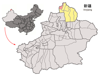
Emin County, the official romanized name, also transliterated from Mongolian as Dörbiljin County, is a county situated in the north of the Xinjiang Uyghur Autonomous Region and is under the administration of the Tacheng Prefecture, bordering Kazakhstan's districts of Tarbagatay and Zaysan. It has an area of 9,092 km2 (3,510 sq mi) with a population of 200,000. The Postcode is 834600.

Yanqi Hui Autonomous County is an autonomous county in the Xinjiang Uyghur Autonomous Region and is under the administration of the Bayin'gholin Mongol Autonomous Prefecture. It has an area of 2,429 km2 (938 sq mi). According to the 2002 census, it has a population of 120,000. The Shikshin Buddhist Temple Ruins are located in Yanqi County, about 25–30 km (16–19 mi) southwest of the town of Yanqi.

Manas County is a county in the Xinjiang Uyghur Autonomous Region under the administration of the Changji Hui Autonomous Prefecture. It covers an area of 9,174 square kilometres (3,542 sq mi) and as of the 2002 census it had a population of 170,000.

Mori Kazakh Autonomous County is a county within the Xinjiang Uyghur Autonomous Region and is under the administration of the Changji Hui Autonomous Prefecture. It contains an area of 13,510 km2. According to the 2002 census, it has a population of 90,000.
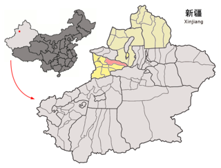
Wenquan County as the official romanized name, also transliterated from Mongolian as Arixang County, is a county in the northwest of the Xinjiang Uyghur Autonomous Region and is under the administration of the Börtala Mongol Autonomous Prefecture, bordering Kazakhstan's Almaty Region to the north and west. It contains an area of 5,900 km2 (2,300 sq mi). According to the 2002 census, it has a population of 70,000.
Ürümqi County is a county of Xinjiang Uyghur Autonomous Region, Northwest China, it is under the administration of the prefecture-level city of Ürümqi, the capital of Xinjiang. It contains an area of 4,601 km² and according to the 2002 census has a population of 80,000.
Nilka(pinyin: Nílèkè) County is a county situated in Xinjiang Uyghur Autonomous Region, China and is under the administration of the Ili Kazakh Autonomous Prefecture. It contains an area of 10,121 km2 (3,908 sq mi). According to the 2002 census, it has a population of 150,000.
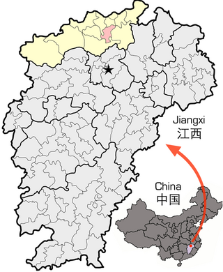
Lushan City, formerly Xingzi County, is a county-level city in the north of Jiangxi Province, China. It is under the administration of the prefecture-level city of Jiujiang.

Minle County is a county in Gansu province of China, bordering Qinghai province to the south. It is under the administration of the prefecture-level city of Zhangye. Its postal code is 734500, and in 1999 its population was 232,462 people. The GDP per capita is US$1,605 in 2010.
Wangqing County is a county of southeastern Jilin province, China. It is under the administration of the Yanbian Korean Autonomous Prefecture. The county's name Wangqing comes from the Manchu language meaning fortress.

Tekes County is a county within the Xinjiang Uyghur Autonomous Region and is under the administration of the Ili Kazakh Autonomous Prefecture. It contains an area of 8,067 km2. According to the 2002 census, it has a population of 150,000.
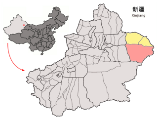
Yizhou is the central district of the Hami prefecture-level city, in Xinjiang Uyghur Autonomous Region, China. Its population was 472,175 at the end of 2010. It was known as Hami county-level city until February 2016, when it was merged with the Hami Prefecture to form the Hami prefecture-level city and the county-level city was renamed Yizhou District. Xingxingxia (Singsingsia) town is located on the border with Gansu.
Tazhong is a town in Qiemo County, Bayingolin Mongol Autonomous Prefecture, Xinjiang. Tazhong administers one community: Tazhong Community. Tazhong was created on July 24, 2015. The population is typically around 20,000, 90% of which are temporary residents.


