Yunguyo

Last updated

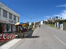
Street in Yunguyo leading to the border crossing to Bolivia Yunguyo Peru.jpg
Street in Yunguyo leading to the border crossing to Bolivia

Yunguyo is a town in the Puno Region in southeastern Peru. It is the capital of Yunguyo Province and Yunguyo District. It has a population of 12,625 (2008 estimate).

Yunguyo is located on a peninsula on the shores of Lake Titicaca. The border with Bolivia runs next to the town and a road connects it with the town of Copacabana located a few kilometers away on the Bolivian side of the peninsula.

Climate

Climate data for Tahuaco-Yunguyo (elevation 3,888 m (12,756 ft), 1991–2020 normals)
MonthJanFebMarAprMayJunJulAugSepOctNovDecYear
Average high °C (°F)14.7
(58.5)
14.9
(58.8)
15.0
(59.0)
15.1
(59.2)
14.5
(58.1)
13.4
(56.1)
13.2
(55.8)
14.1
(57.4)
14.9
(58.8)
15.8
(60.4)
16.5
(61.7)
15.8
(60.4)
14.8
(58.7)
Average low °C (°F)4.0
(39.2)
3.9
(39.0)
3.7
(38.7)
2.2
(36.0)
−0.4
(31.3)
−2.0
(28.4)
−2.0
(28.4)
−0.8
(30.6)
1.0
(33.8)
2.2
(36.0)
3.2
(37.8)
3.9
(39.0)
1.6
(34.9)
Average precipitation mm (inches)174.3
(6.86)
145.0
(5.71)
120.3
(4.74)
41.0
(1.61)
11.4
(0.45)
10.4
(0.41)
9.7
(0.38)
18.5
(0.73)
27.0
(1.06)
47.3
(1.86)
54.6
(2.15)
98.7
(3.89)
758.2
(29.85)
Source: National Meteorology and Hydrology Service of Peru [1]

16°14′39.06″S69°05′33.95″W / 16.2441833°S 69.0927639°W / -16.2441833; -69.0927639

  1. "Normales Climáticas Estándares y Medias 1991-2020". National Meteorology and Hydrology Service of Peru. Archived from the original on 21 August 2023. Retrieved 25 October 2023.

Related Research Articles

<span class="mw-page-title-main">Department of Puno</span> Departments of Peru

Puno is a department and region in southeastern Peru. It is the fifth largest department in Peru, after Cuzco, Madre de Dios, Ucayali, and Loreto. It is bordered by Bolivia on the east, the departments of Madre de Dios on the north, Cusco and Arequipa on the west, Moquegua on the southwest, and Tacna on the south. Its capital is the city of Puno, which is located on Lake Titicaca in the geographical region known as the Altiplano or high sierra.

<span class="mw-page-title-main">Eliodoro Camacho Province</span> Province in La Paz Department, Bolivia

Eliodoro Camacho is a province in the La Paz Department in Bolivia situated at Lake Titicaca. Its seat is Puerto Acosta.

<span class="mw-page-title-main">Manco Kapac Province</span> Province in La Paz Department, Bolivia

Manco Kapac is a province in the Bolivian department of La Paz. Its capital is Copacabana.

<span class="mw-page-title-main">Achacachi</span> Place in La Paz Department, Bolivia

Achacachi is a town on the Altiplano plateau in the South American Andes in the La Paz Department in Bolivia. It is the capital of the Omasuyos Province.

<span class="mw-page-title-main">Taraco</span>

Taraco is a peninsula jutting into Lake Wiñaymarka, the southern branch of Lake Titicaca in Bolivia. It is located in the La Paz Department, Ingavi Province, Tiwanaku Municipality, Taraco Canton. There is also a town of the same name on the peninsula.

<span class="mw-page-title-main">Yunguyo Province</span> Province in Puno, Peru

Yunguyo Province is a province of the Puno Region in Peru. The capital of the province is the city of Yunguyo.

<span class="mw-page-title-main">Juli District</span> District in Puno, Peru

Juli District is one of seven districts of the Chucuito Province in Puno Region, Peru.

Anapia District is one of seven districts of the province Yunguyo in Puno Region, Peru.

Copani District is one of seven districts of the province Yunguyo in Puno Region, Peru.

Cuturapi District is one of seven districts of the province Yunguyo in Peru.

Ollaraya District is one of seven districts of the province Yunguyo in Puno, Peru.

Unicachi District is one of seven districts of the province Yunguyo in Puno Region, Peru.

<span class="mw-page-title-main">Yunguyo District</span> District in Puno, Peru

Yunguyo District is one of seven districts of the province Yunguyo in Peru.

<span class="mw-page-title-main">Desaguadero, Bolivia-Peru</span> Place in Puno Region

Desaguadero or Chaka Marka is a town on the Bolivian-Peruvian border. On the Bolivian side it is situated in the La Paz Department, Ingavi Province, Desaguadero Municipality, Desaguadero Canton. On the Peruvian side it lies in the Puno Region, Chucuito Province, Desaguadero District. Both parts of the town are united by a binational bridge.

<span class="mw-page-title-main">Bolpebra</span>

Tupu Inka is an archaeological site in Peru. It is located in the Puno Region, Yunguyo Province, Unicachi District.

<span class="mw-page-title-main">Asiru Phat'jata</span> Archaeological site in Peru

Asiru Phat'jata is a hill in Peru, situated at a height of about 3,895 metres (12,779 ft). It is located in the Puno Region, Yunguyo Province, Yunguyo District. Asiru Phat'jata lies near Lake Titicaca at the road which connects Yunguyo and Puno, south of the village Asiru Phat'jata (Acero Patjata) and north of the mountain Qhapiya.

Ichocollo or Ichucollo is a mountain in the Apolobamba mountain range at the border of Bolivia and Peru, about 5,423 metres (17,792 ft) high. According to the Bolivian IGM (Instituto Geográfico Militar) map and a map edited by the Peruvian Ministry of Education it is located in the La Paz Department, Franz Tamayo Province, Pelechuco Municipality, near 14°41′57″S69°14′55″W. According to reports of mountaineers, however, its position is more to the west on the Peruvian border of the Puno Region, Putina Province, Ananea District, near 14°41′30″S69°15′30″W. This information is based on a DAV (Deutscher Alpenverein) map of 1957.

Route 2 is a National Road in Bolivia. It connects La Paz to Khasani via Batallas and Copacabana, is paved for its entire length.