Zacateco

Last updated
Zacateco
Total population
Unknown
Regions with significant populations
Mexico (Zacatecas, Durango)
Languages
Spanish
Religion
Christianity especially Roman Catholic
Related ethnic groups
Caxcan, Guachichil, Guamare, Tepehuán, Pame, Tecuexe
Map of Zacateco and surrounding nations during the 16th century ChichimecNations.png
Map of Zacateco and surrounding nations during the 16th century
Territorio Zacateco Territorio Zacateco.png
Territorio Zacateco

The Zacatecos (or Zacatecas) is the name of an indigenous group, one of the peoples called Chichimecas by the Aztecs. They lived in most of what is now the state of Zacatecas and the northeastern part of Durango. They have many direct descendants, but most of their culture and traditions have disappeared with time. Large concentrations of modern-day descendants may reside in Zacatecas and Durango, as well as other large cities of Mexico.

Contents

Name

"Zacateco" is a Mexican Spanish derivation from the original Nahuatl Zacatecatl, pluralized in early Mexican Spanish as Zacatecas, the name given to the state and city. The name was given by the Aztecs to the people inhabiting a region in which a grass they called the zacatl was abundant. The region was thus called Zacatlan by the Aztecs. (Mexica)

History

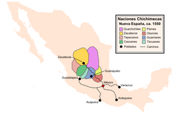
The Zacateco united militarily with other Chichimeca nations to form the Chichimeca Confederation to defeat the Spaniards during the Chichimeca War (1550-90). See Chichimeca War.

The Chichimeca War

Geography

To the east and north they overlapped lands with the Guachichiles. They extended to border the Tepehuanes to the west near Durango. To the north their land bordered that of the Irritilas or Laguna tribes, up to were Cuencamé and Parras are located. Their principal population centers were in Malpaís, around Peñón Blanco, and around the Cerro de la Bufa. They also extended down to what is now Los Altos Jalisco and overlapped territory with the Caxcanes.

Culture

Way of Life

Most Zacatecos were nomadic, although a few groups were essentially sedentary. Both men and women wore their hair down to their waist. Some Chichimeca tribes wore their head braided, but it is unspecified if any Zacatec tribes did so. They used body paint and tattoos to distinguish themselves from other tribes. Zacatecos were known to wear skin coverings below their knees and skin headbands on their foreheads. Occasionally they wore leather-soled sandals. They were "graceful, strong, robust and beardless". Juan Bautista de Pomar commented, "In the opinion of men experienced in foreign lands, the Zacatecos are the best archers in the world."

Religion

The Zacatecos were a nomadic tribe and others were sedentary which means they lived in one area. Some tribes did in fact have temples dedicated to some kind of worship in the southwestern part of the state of Zacatecas. In a town called El Teul Gonzalez De Ortega there is a hill called el cerro del sombrero upon this hill there are temples ball courts and also ancient channels where the tribe extracted fresh water from the hill.

Conclusion

The Zacatecos as a culture have vanished or faded, due to assimilation and mestizaje of the Mexican people. However many of their direct descendants still live in large concentrations in central Mexico. Taking all this into account, it is extremely difficult to even approximate the population of their descendants. It is equally hard to elaborate on their culture, language, art, and traditions.

Related Research Articles

Zacatecas City City in Zacatecas, Mexico

Zacatecas is the principal city within the municipality in Mexico of the same name, and the capital and the largest city of the state of Zacatecas. Located in north-central Mexico, the city had its start as a Spanish mining camp in the mid-16th century. Native Americans had already known about the area's rich deposits of silver and other minerals. Due to the wealth that the mines provided, Zacatecas quickly became one of the most important mining cities in New Spain. The area saw battles during the turbulent 19th century, but the next major event was the Battle of Zacatecas during the Mexican Revolution when Francisco Villa captured the town, an event still celebrated every anniversary. Today, the colonial part of the city is a World Heritage Site, due to the Baroque and other structures built during its mining days. Mining still remains an important industry. The name Zacatecas is derived from the Zacateco people and has its roots in Nahuatl. The name means "people of the grasslands".

Chichimeca Ethnic group

Chichimeca is the name that the Nahua peoples of Mexico generically applied to nomadic and semi-nomadic peoples who were established in present-day Bajio region of Mexico. Chichimeca carried the same sense as the Roman term "barbarian" to describe Germanic tribes. The name, with its pejorative sense, was adopted by the Spanish Empire. For the Spanish, in the words of scholar Charlotte M. Gradie, "the Chichimecas were a wild, nomadic people who lived north of the Valley of Mexico. They had no fixed dwelling places, lived by hunting, wore little clothes and fiercely resisted foreign intrusion into their territory, which happened to contain silver mines the Spanish wished to exploit." In spite of not having temples or idols, they practiced animal and human sacrifice, and they were feared for their expertise and brutality in war.

The Tlaxcalans, or Tlaxcaltecs, are a Nahua people who live in the Mexican state of Tlaxcala.

Guachichil

The Guachichil, Cuauchichil, or Quauhchichitl, are an Indigenous people of Mexico. Pre-contact, they occupied the most extensive territory of all the indigenous Chichimeca Nations tribes in pre-Columbian Central Mexico.

Caxcan

The Caxcan were a partly nomadic indigenous people of Mexico. Under their leader, Tenamaztle, the Caxcan were allied with the Zacatecos against the Spaniards during the Mixtón Rebellion in 1540-42. During the rebellion, they were described as "the heart and the center of the Indian Rebellion". After the rebellion, they were a constant target of the Zacatecos and Guachichiles due to their ceasefire agreement with the Spaniards. Their principal religious and population centers were at Teul, Tlaltenango, Juchipila, and Teocaltiche.

Mixtón War War (1540–1542) between Caxcan and Spanish conquerors

The Mixtón War (1540-1542) was a rebellion by the Caxcan people of northwestern Mexico against the Spanish conquerors. The war was named after Mixtón, a hill in Zacatecas which served as an Indigenous stronghold.

Chichimeca War 16th-century Spanish invasion of Mesoamerica

The Chichimeca War (1550–90) was a military conflict between the Spanish Empire and the Chichimeca Confederation established in the territories today known as the Central Mexican Plateau, called by the Conquistadores La Gran Chichimeca. The epicenter of the hostilities was the region now called the Bajío. The Chichimeca War is recorded as the longest and most expensive military campaign confronting the Spanish Empire and indigenous people in Mesoamerica. The forty-year conflict was settled through several peace treaties driven by the Spaniards which led to the pacification and, ultimately, the streamlined integration of the native populations into the New Spain society.

Guamare

The Guamare people were an indigenous people of Mexico, who were established mostly in Guanajuato and at the border of Jalisco. They were part of the Chichimecas, a group of a nomadic hunter-gatherer culture and called themselves Children of the Wind, living religiously from the natural land. As a tradition, they would cremate their dead and spread their ashes into the wind back to 'Mother Earth'. The Guamare people were politically united with the Chichimeca Confederation, but like other Chichimeca nations were independent. The Chichimeca were established in the present-day Bajio region of Mexico.

Tecuexe

The Tecuexe were an indigenous peoples of Mexico, who lived in the eastern part of present-day Guadalajara.

Sombrerete, Zacatecas City & Municipality in Zacatecas, Mexico

Sombrerete is a town and municipality located in the northwest of the Mexican state of Zacatecas, bordering the state of Durango.

Bolsón de Mapimí Basin in the center-north of the Mexican Plateau

The Bolsón de Mapimí is an endorheic, or internal drainage, basin in which no rivers or streams drain to the sea, but rather toward the center of the basin, often terminating in swamps and ephemeral lakes. It is located in the center-north of the Mexican Plateau. The basin is shared by the states of Durango, Coahuila, Chihuahua, and Zacatecas. It takes its name from Mapimí, a town in Durango.

Tepehuán Revolt

The Tepehuán Revolt broke out in Mexico in 1616 when the Tepehuán Indians attempted to break free from Spanish rule. The revolt was crushed by 1620 after a large loss of life on both sides.

Peralta (Mesoamerican site)

Peralta is a prehispanic mesoamerican archaeological site located in Abasolo Municipality, Guanajuato, just outside the village of San Jose de Peralta in the Mexican state of Guanajuato. The site is reached via Fed 90 from Irapuato. Approximately 15.5 km south of the intersection with Fed 45, take the Irapuato-Huanimaro route southeast (left). Follow the route for about 12.5 km, then turnoff southwest (right) to San Jose de Peralta. Cross the bridge and turn right, and then follow the road out of the village northwest about 1 km. The site is on the left.

Plazuelas Prehispanic archaeological site in Mexico

Plazuelas is a prehispanic archaeological site located just north of San Juan el Alto, some 2.7 kilometers (1.57 mi.) north of federal highway 90 (Pénjamo-Guadalajara), and about 11 kilometers (6.8 mi.) west of the city of Pénjamo in the state of Guanajuato, Mexico. The site is open to the public; it is dominated by a large, rectangular plaza with several pyramidal structures and platforms, along with a massive ball court. To the north of the structures is a field of boulders with thousands of glyphs carved into them.

Francisco Tenamaztle

Francisco Tenamaztle, also Tenamaxtlan, Tenamaxtli or Tenamaxtle, was a leader of the Caxcan indigenous peoples in Mexico during the Mixtón War of 1540–1542. He was later put on trial in Spain. With the support of Bartolomé de las Casas he defended the justice of his cause by appealing to King Carlos I.

El Cóporo is a prehispanic archaeological site at the northern frontiers of the Mesoamerican cultural area, located at an elevation of 150 meters on the western slopes of the Santa Bárbara range, near the San José del Torreón community, and lies some 15 kilometres (9 mi) due south of its municipal seat and largest township, on the northwestern corner of Guanajuato state, Mexico.

El Opeño is a Mesoamerican archaeological site located in the municipality of Jacona in the state of Michoacán, Mexico. It is home to a prehispanic site, mainly known from the ceramic material found in the funerary complexes of the site, which have been dated to the Late Preclassic period. The importance of this site in mesoamerican archaeology is due to its antiquity and the ample diffusion of its style, contemporary to other native culture developments such as the Capacha culture and earlier than the Chupicuaro. El Opeño tombs, the oldest in Mesoamerica, have been dated to around 1600 BCE - a similar period as Olmec culture development.

El Teúl is an important archaeological Mesoamerican site located on a hill with the same name in the Teúl Municipality in the south of the Zacatecas State, Mexico, near the Jalisco State.

La Ferrería Archaeological site in Durango, Mexico

La Ferrería is an archaeological site located 7 kilometers south of the City of Durango, in the state of Durango, México, at the “Cerro de La Ferrería”, on the side of the Tunal River.

Huandacareo

Huandacareo is an archaeological zone located about 60 kilometers north of the city of Morelia, in the state of Michoacán.

References