Zambezian coastal flooded savanna

Last updated
Zambezian coastal flooded savanna
Zambezi Delta diversity ESA394392.jpg
Zambezi River delta
Ecoregion AT0906.png
Map of the Zambezian coastal flooded savanna
Ecology
Realm Afrotropical
Biome flooded grasslands and savannas
Borders
Geography
Area19,346 km2 (7,470 sq mi)
Countries Mozambique
Conservation
Protected6,212 km² (32%) [1]

The Zambezian coastal flooded savanna is a flooded grasslands and savannas ecoregion in Mozambique. It includes the coastal flooded savannas and grasslands in the deltas of the Zambezi, Pungwe, Buzi, and Save rivers. [2]

Contents

Geography

The Zambezi, Pungwe, Buzi, and Save rivers drain extensive areas of interior Southeast Africa. Rainfall in the region is highly seasonal, and the volume of water carried by these rivers varied with the wet and dry cycles of the year. The flooded savannas are found in low-lying coastal lowlands at the river mouths, on deposits of recent fluvisols deposited by the rivers. [2]

They Zambezian coastal flooded savannas cover an area of 19,346 km². The Zambezi flooded savannas cover the largest area, extending nearly 200 km along the Indian Ocean coast and extending up to 120 km inland. To the south are the adjoining floodplains of the Pungwe and Buzi, which create a flooded savanna of 4500 km². The smaller Save River flooded savannas lie further to the south. The East African mangroves lie between the flooded savannas and the coast in areas of brackish or salt water. [2]

The Southern Zanzibar-Inhambane coastal forest mosaic ecoregion occupies the coastal uplands adjacent to the flooded savannas. The drier Zambezian and mopane woodlands occupy the inland river valleys.

Flora

The plant communities include flooded grasslands, flooded savannas, and freshwater swamp forests, which vary with soils and the duration of flooding. Reed swamps of Phragmites australis and Typha capensis are common in permanently-flooded areas. The grasses Hyparrhenia, Ischaemum , and Setaria predominate in seasonally-flooded areas with clay soil. Trees and shrubs of the flooded savannas include Parinari curatellifolia, Uapaca nitida , and Syzygium guineense . There are areas of Borassus aethiopum palm savanna. Swamp forests grow at the edges of rivers, lakes, and lagoons, and characteristic trees include Barringtonia racemosa, Ficus verruculosa , and the palm Phoenix reclinata . [2]

Fauna

Large mammals in the ecoregion include hippo (Hippopotamus amphibius), African buffalo (Syncerus caffer caffer), waterbuck (Kobus ellipsiprymnus), southern reedbuck (Redunca arundium), plains zebra (Equus quagga), Nyala (Tragelaphus angasi), blue wildebeest (Connochaetes taurinus), steenbok (Raphicerus campestris), and common warthog (Phacochoerus africanus). Mammal predators include the lion (Panthera leo), leopard (P. pardus), cheetah (Acinonyx jubatus), spotted hyena (Crocuta crocuta), side-striped jackal (Canis adustus), Cape genet (Genetta tigrina), African civet (Civettictis civetta), serval (Leptailurus serval), African clawless otter (Aonyx capensis), spotted-necked otter (Hydrictis maculicollis), banded mongoose (Mungos mungo), white-tailed mongoose (Ichneumia albicauda), and bushy-tailed mongoose (Bdeogale crassicauda).

Some large mammals migrate seasonally between the flooded savannas and the grasslands, forests, and woodlands of the neighboring uplands. Common eland (Taurotragus oryx) migrates to the seasonal wetlands at the start of the rainy season to browse on the young grasses. Populations of Lichtenstein’s hartebeest (Alcelaphus lichtensteinii) and sable antelope (Hippotragus niger) live in the flooded savannas during the dry season, and migrate to the uplands at the start of the rainy season. [2]

The flooded savannas are home to large populations of resident and migratory water birds, including African openbill stork (Anastomus lamelligerus), saddle-billed stork (Ephippiorhynchus senegalensis), lesser flamingo (Phoeniconaias minor), great white pelican (Pelecanus onocrotalus), great snipe (Gallinago media), and African skimmer (Rynchops flavirostris). [2]

Conservation and threats

The construction of large dams on the Zambezi – Kariba Dam, completed in 1959, and Cahora Bassa Dam, completed in 1974 – altered the ecology of the Zambezi, reducing the annual wet-season flooding of the lower Zambezi and the overall volume of both water and sediment coming into the flooded savannas. Other threats include poaching and over-hunting. Wildlife was decimated during the Mozambican Civil War, and the African bush elephant (Loxodonta africana) and black rhinoceros (Diceros bicornis) were extirpated. [2]

Protected areas

A 2017 assessment found that 6,212 km², or 32%, of the ecoregion is in protected areas. [3] Protected areas include Marromeu National Reserve in the southwestern Zambezi delta, and the adjacent coutadas or hunting areas. Gorongosa National Park protects a portion of the northern Pungwe floodplain.

Related Research Articles

Geography of Mozambique

The geography of Mozambique consists mostly of coastal lowlands with uplands in its center and high plateaus in the northwest. There are also mountains in the western portion. The country is located on the east coast of southern Africa, directly west of the island of Madagascar. Mozambique has a tropical climate with two seasons, a wet season from October to March and a dry season from April to September.

The Global 200 is the list of ecoregions identified by WWF, the global conservation organization, as priorities for conservation. According to WWF, an ecoregion is defined as a "relatively large unit of land or water containing a characteristic set of natural communities that share a large majority of their species dynamics, and environmental conditions". So, for example, based on their levels of endemism, Madagascar gets multiple listings, ancient Lake Baikal gets one, and the North American Great Lakes get none.

Afrotropical realm One of the Earths eight [[biogeographic realm]]s

The Afrotropical realm is one of the Earth's eight biogeographic realms. It includes Africa south of the Sahara Desert, the majority of the Arabian Peninsula, the island of Madagascar, southern Iran and extreme southwestern Pakistan, and the islands of the western Indian Ocean. It was formerly known as the Ethiopian Zone or Ethiopian Region.

Flooded grasslands and savannas Habitat type defined by the World Wide Fund for Nature

Flooded grasslands and savannas is a terrestrial habitat type of the WWF biogeographical system, consisting of large expanses or complexes of flooded grasslands. These areas support numerous plants and animals adapted to the unique hydrologic regimes and soil conditions. Large congregations of migratory and resident waterbirds may be found in these regions. However, the relative importance of these habitat types for these birds as well as more vagile taxa typically varies as the availability of water and productivity annually and seasonally shifts among complexes of smaller and larger wetlands throughout a region.

Zambezian flooded grasslands

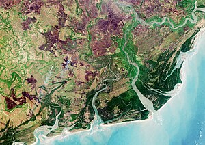
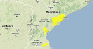
The Zambezian flooded grasslands is an ecoregion of southern and eastern Africa that is rich in wildlife.

The biomes and ecoregions in the ecology of Zambia are described, listed and mapped here, following the World Wildlife Fund's classification scheme for terrestrial ecoregions, and the WWF freshwater ecoregion classification for rivers, lakes and wetlands. Zambia is in the Zambezian region of the Afrotropical biogeographic realm. Three terrestrial biomes are well represented in the country . The distribution of the biomes and ecoregions is governed mainly by the physical environment, especially climate.

Angolan miombo woodlands

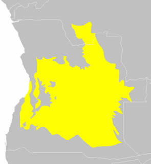
Angolan miombo woodlands cover most of central Angola and extend into the Democratic Republic of Congo. They are part of the larger miombo ecosystem that covers much of eastern and southern Africa.

The Angolan Scarp savanna and woodlands is an ecoregion located on the coast of Angola, an area with a variety of habitats and rich in wildlife including many endemic birds and animals.

Carpentaria tropical savanna terrestrial ecoregion in Australia

The Carpentaria tropical savanna is a tropical and subtropical grasslands, savannas, and shrublands ecoregion in northern Australia.

Zambezian and mopane woodlands

The Zambezian and mopane woodlands is a tropical and subtropical grasslands, savannas, and shrublands ecoregion of southeastern Africa.

West Sudanian savanna terrestrial ecoregion in West Africa

The West Sudanian savanna is a tropical savanna ecoregion that extends across West Africa.

Cheringoma Plateau

The Cheringoma Plateau is a low plateau in Sofala Province of Mozambique. It lies mostly within Cheringoma, Muanza, and Marromeu districts.

Southern miombo woodlands Ecoregion (WWF)

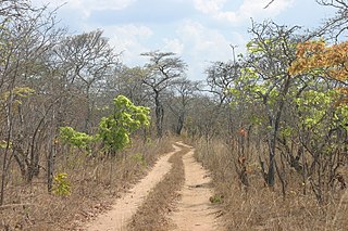
The Southern miombo woodlands is a tropical grasslands and woodlands ecoregion extending across portions of Malawi, Mozambique, Zambia, and Zimbabwe.

The Urema Valley, also known as the Urema Graben, is a lowland valley in Sofala Province of central Mozambique.

Mitchell Grass Downs

The Mitchell Grass Downs is a tropical and subtropical grasslands, savannas, and shrublands ecoregion in northeastern Australia. It is a mostly treeless grassland, characterised by Mitchell grasses.

The Southeastern Papuan rain forests is a tropical moist forest ecoregion in southeastern New Guinea. The ecoregion covers portions of New Guinea's southern lowlands.

References

  1. Eric Dinerstein, David Olson, et al. (2017). An Ecoregion-Based Approach to Protecting Half the Terrestrial Realm, BioScience, Volume 67, Issue 6, June 2017, Pages 534–545; Supplemental material 2 table S1b.
  2. 1 2 3 4 5 6 7 "Zambezian coastal flooded savanna". Terrestrial Ecoregions. World Wildlife Fund.
  3. Eric Dinerstein, David Olson, et al. (2017). An Ecoregion-Based Approach to Protecting Half the Terrestrial Realm, BioScience, Volume 67, Issue 6, June 2017, Pages 534–545; Supplemental material 2 table S1b.