Zap, North Dakota

Last updated

Zap, North Dakota
Zap, North Dakota.jpg
Immanuel Lutheran Church in Zap
Nickname: 
"The little town with a big heart"
ND Mercer County Zap.svg
Location of Zap, North Dakota
Coordinates: 47°17′05″N101°55′24″W / 47.28472°N 101.92333°W / 47.28472; -101.92333
CountryUnited States
State North Dakota
County Mercer
Founded1913
Area
[1]
  Total1.02 sq mi (2.64 km2)
  Land1.02 sq mi (2.64 km2)
  Water0.00 sq mi (0.01 km2)
Elevation
[2]
1,844 ft (562 m)
Population
 (2020)
  Total221
  Density217.09/sq mi (83.78/km2)
Time zone UTC-6 (CST)
  Summer (DST) UTC-6 (MDT)
ZIP code
58580
Area code 701
FIPS code 38-88140
GNIS feature ID1036345 [2]
Website wrtc.com/zapnd

Zap is a city in Mercer County, North Dakota, United States. The population was 221 at the 2020 census. [3]

Contents

Zap was founded in 1913 along a branch line of the Northern Pacific Railway that began in Mandan. The exact origin of the name is uncertain, though there are numerous unconfirmed theories; some say the town was named after Zapp, which was either a prominent Minnesota banking family or a coal-mining town in Scotland. [4] [5] Zap has been noted for its unusual place name. [6]

The "Zip to Zap"

The town of Zap is probably most widely known for the Zip to Zap riot, which occurred on May 10, 1969. The Zip to Zap was originally intended as a spring break diversion. Between 2000 and 3000 people descended upon the town after an article by Chuck Stroup, originally appearing in the North Dakota State University Spectrum newspaper, and then later picked up by the Associated Press, persuaded busloads and chartered planes full of people from around the United States to go there.

The amiable revelry began early with an all-night party in the streets outside an overwhelmed small bar. When the mayor finally exited the bar in the middle of the night and discovered a bonfire on main street and realized the size of the crowd in his tiny town, he panicked and called the governor, William Guy. At dawn, marching in formation and armed with bayonets placed, the National Guard invaded the town and forced the crowd to leave Zap. The event moved to several other towns before the Governor announced that a park in Bismarck would host the crowd. The then-popular rock station, KFYR, and their disc jockeys were in communication with event organizers and falsely reported where the crowd had gone before they arrived, effectively directing all the listeners on which small town and park to proceed to next. In one village, locals cleaned out the Farmers Union of every implement handle in order to patrol their town against the wave of invading hippies and cowboys.

Geography

Zap is located in the prairie country along Spring Creek, a tributary of the Knife River.

According to the United States Census Bureau, the city has a total area of 1.05 square miles (2.72 km2), all land. [7]

Climate

Climate data for Zap - Beulah Field
MonthJanFebMarAprMayJunJulAugSepOctNovDecYear
Average high °F (°C)19.6
(−6.9)
21.1
(−6.1)
36.5
(2.5)
52.9
(11.6)
64.6
(18.1)
74.0
(23.3)
83.1
(28.4)
80.8
(27.1)
70.5
(21.4)
55.5
(13.1)
44.3
(6.8)
20.6
(−6.3)
52.0
(11.1)
Average low °F (°C)−3.7
(−19.8)
1.1
(−17.2)
14.7
(−9.6)
30.0
(−1.1)
37.4
(3.0)
48.9
(9.4)
56.1
(13.4)
50.8
(10.4)
41.9
(5.5)
27.6
(−2.4)
19.9
(−6.7)
−0.8
(−18.2)
27.0
(−2.8)
Average precipitation inches (mm)0.4
(10)
0.4
(10)
0.6
(15)
1.1
(28)
2.0
(51)
3.3
(84)
2.4
(61)
1.8
(46)
1.1
(28)
1.1
(28)
0.5
(13)
0.4
(10)
15.1
(380)
Source: Weatherbase [8]

Demographics

Historical population
CensusPop.Note
1920 257
1930 40658.0%
1940 57441.4%
1950 425−26.0%
1960 339−20.2%
1970 271−20.1%
1980 51188.6%
1990 287−43.8%
2000 231−19.5%
2010 2372.6%
2020 221−6.8%
2021 (est.)223 [9] 0.9%
U.S. Decennial Census [10]
2020 Census [3]

2010 census

As of the census of 2010, there were 237 people, 109 households, and 70 families residing in the city. The population density was 225.7 inhabitants per square mile (87.1/km2). There were 135 housing units at an average density of 128.6 per square mile (49.7/km2). The racial makeup of the city was 91.6% White, 3.0% Native American, 1.3% Asian, and 4.2% from two or more races. Hispanic or Latino of any race were 0.4% of the population.

There were 109 households, of which 24.8% had children under the age of 18 living with them, 47.7% were married couples living together, 8.3% had a female householder with no husband present, 8.3% had a male householder with no wife present, and 35.8% were non-families. 31.2% of all households were made up of individuals, and 11% had someone living alone who was 65 years of age or older. The average household size was 2.17 and the average family size was 2.63.

The median age in the city was 49.1 years. 17.7% of residents were under the age of 18; 9.3% were between the ages of 18 and 24; 18.2% were from 25 to 44; 38.8% were from 45 to 64; and 16% were 65 years of age or older. The gender makeup of the city was 54.0% male and 46.0% female.

2000 census

As of the census of 2000, there were 231 people, 101 households, and 68 families residing in the city. The population density was 221.8 inhabitants per square mile (85.6/km2). There were 129 housing units at an average density of 123.8 per square mile (47.8/km2). The racial makeup of the city was 95.24% White, 3.90% Native American, and 0.87% from two or more races.

There were 101 households, out of which 25.7% had children under the age of 18 living with them, 60.4% were married couples living together, 4.0% had a female householder with no husband present, and 31.7% were non-families. 29.7% of all households were made up of individuals, and 14.9% had someone living alone who was 65 years of age or older. The average household size was 2.29 and the average family size was 2.78.

In the city, the population was spread out, with 21.6% under the age of 18, 5.2% from 18 to 24, 25.5% from 25 to 44, 33.3% from 45 to 64, and 14.3% who were 65 years of age or older. The median age was 44 years. For every 100 females, there were 100.9 males. For every 100 females age 18 and over, there were 92.6 males.

The median income for a household in the city was $30,536, and the median income for a family was $34,063. Males had a median income of $30,625 versus $18,125 for females. The per capita income for the city was $16,175. About 5.2% of families and 10.9% of the population were below the poverty line, including 18.6% of those under the age of eighteen and 18.2% of those 65 or over.

Related Research Articles

<span class="mw-page-title-main">Minnewaukan, North Dakota</span> City in North Dakota, United States

Minnewaukan is a city in Benson County, North Dakota, United States. It serves as the county seat and is fourth largest city in the county, after Fort Totten, Leeds, and Maddock. The population was 199 at the 2020 census. Minnewaukan was founded in 1884.

<span class="mw-page-title-main">Westhope, North Dakota</span> City in North Dakota, United States

Westhope is a city in Bottineau County, North Dakota, United States. The population was 374 at the 2020 census. Westhope was founded in 1903 along a Great Northern Railway branch line that began in Rugby. The name was based on the slogan "Hope of the West," created by Great Northern officials to promote prosperity for the new town.

<span class="mw-page-title-main">Alice, North Dakota</span> City in North Dakota, United States

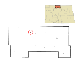
Alice is a city in Cass County, North Dakota, United States. The population was 41 at the 2020 census.

<span class="mw-page-title-main">New Rockford, North Dakota</span> City in North Dakota, United States

New Rockford is a city in Eddy County, North Dakota, United States. It is the county seat of Eddy County. The population was 1,361 at the 2020 census. New Rockford was founded in 1883.

<span class="mw-page-title-main">Hoople, North Dakota</span> City in North Dakota, United States

Hoople is a city in Walsh County, North Dakota, United States. The population was 247 at the 2020 census. Hoople, named for early settler Alan Hoople, was founded in 1889. Hoople's nickname is "Tatertown."

<span class="mw-page-title-main">Martin, South Dakota</span> City in South Dakota, United States

Martin is a city and the county seat of Bennett County, South Dakota, United States. The population was 938 at the 2020 census.

<span class="mw-page-title-main">Mound City, South Dakota</span> Town in South Dakota, United States

Mound City is a town in and the county seat of Campbell County, South Dakota, United States. The population was 69 at the 2020 census.

<span class="mw-page-title-main">Wagner, South Dakota</span> City in South Dakota, United States

Wagner is a city in Charles Mix County, South Dakota, United States. The population was 1,490 at the 2020 census. The city is served by Wagner Municipal Airport as well as YST Transit buses.

<span class="mw-page-title-main">Garden City, South Dakota</span> Town in South Dakota, United States

Garden City is a town in Clark County, South Dakota, United States. The population was 33 at the 2020 census.

<span class="mw-page-title-main">Florence, South Dakota</span> Town in South Dakota, United States

Florence is a town in northwestern Codington County, South Dakota, United States. It is part of the Watertown, South Dakota Micropolitan Statistical Area. The population was 337 at the 2020 census.

<span class="mw-page-title-main">Clear Lake, South Dakota</span> City in South Dakota, United States

Clear Lake is a city in and the county seat of Deuel County, South Dakota, United States. The population was 1,218 at the 2020 census.

<span class="mw-page-title-main">Corsica, South Dakota</span> City in South Dakota, United States

Corsica is a city in Douglas County, South Dakota, United States. The population was 561 at the 2020 census.

<span class="mw-page-title-main">Miller, South Dakota</span> City in South Dakota, United States

Miller is a city in and county seat of Hand County, South Dakota, United States. The population was 1,349 at the 2020 census.

<span class="mw-page-title-main">Parkston, South Dakota</span> City in South Dakota, United States

Parkston is a city in Hutchinson County, South Dakota, United States. The population was 1,567 at the 2020 census.

<span class="mw-page-title-main">Kadoka, South Dakota</span> City in South Dakota, United States

Kadoka is a city in, and the county seat of, Jackson County, South Dakota, United States. The population was 543 at the 2020 census. The town occupies about 2.3 square miles.

<span class="mw-page-title-main">Whitewood, South Dakota</span> City in South Dakota, United States

Whitewood is a city in Lawrence County, South Dakota, United States. The population was 879 at the 2020 census.

<span class="mw-page-title-main">Lake City, South Dakota</span> Town in South Dakota, United States

Lake City is a town in Marshall County, South Dakota, United States. The population was 45 at the 2020 census. Fort Sisseton Historic State Park, whose fort is listed on the National Register of Historic Places, is located nearby.

<span class="mw-page-title-main">Leola, South Dakota</span> City in South Dakota, United States

Leola is a small city in, and the county seat of, McPherson County, South Dakota, United States. It was founded on May 1, 1884, and named for Leola Haynes, daughter of one of the town's founders. The population was 434 as of the 2020 census.

<span class="mw-page-title-main">Crooks, South Dakota</span> City in South Dakota, United States

Crooks is a city in Minnehaha County, South Dakota, United States and is a suburb of Sioux Falls. The population was 1,362 at the 2020 census. Crooks was named New Hope until 1904. The town's present name honors W. A. Crooks, a local politician.

<span class="mw-page-title-main">Ashton, South Dakota</span> City in South Dakota, United States

Ashton is a city in eastern Spink County, South Dakota, United States. The population was 108 at the 2020 census.

References

  1. "ArcGIS REST Services Directory". United States Census Bureau. Retrieved September 20, 2022.
  2. 1 2 U.S. Geological Survey Geographic Names Information System: Zap, North Dakota
  3. 1 2 "Explore Census Data". United States Census Bureau . Retrieved July 16, 2022.
  4. "Zap History Information". City of Zap. Retrieved May 6, 2011.
  5. Wick, Douglas A. "Zap (Mercer County)". North Dakota Place Names. Retrieved May 6, 2011.
  6. Petras, Kathryn; Petras, Ross (December 18, 2007). Unusually Stupid Americans: A Compendium of All-American Stupidity. Random House Publishing Group. p. 246. ISBN   978-0-307-41761-9.
  7. "US Gazetteer files 2010". United States Census Bureau. Archived from the original on February 20, 2011. Retrieved June 14, 2012.
  8. "Weatherbase: Historical Weather for Zap - Beulah Field, North Dakota". Weatherbase. 2011. Retrieved on November 24, 2011.
  9. "City and Town Population Totals: 2020-2021". United States Census Bureau. July 16, 2022. Retrieved July 16, 2022.
  10. "U.S. Decennial Census". Census.gov. Retrieved June 1, 2013.