
Zeche Carl (Carl Mine) is a cultural centre set up by Essen Council in a former coal mine.
Contents

Zeche Carl (Carl Mine) is a cultural centre set up by Essen Council in a former coal mine.
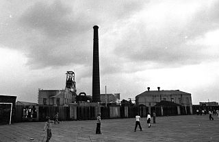
The mine was founded by the Hercules Company in Altenessen in 1855. It should not be confused with the Hercules mine in central Essen. They sank a shaft equipped with a large-sized Malakow tower with two wings. The mine went operational in 1861. That same year Hercules was acquired by the Cologne Mining Association under Friedrich Grillo and was renamed the Zeche Carl.
The mine was soon to develop as it produced high quality Anthracite suitable for producing coke. From 1883, it simply produced Carl Coke. An additional ventilation shaft was drilled between 1885 and 1887.
In 1899 the Malakow tower was upgraded for double conveyance. The production was increased to 300,000 tonnes a year.
After the First World War, the Cologne Mining Association was taken over by Hoesch AG. Coal production was discontinued in 1929. The main shaft was dismantled and the ventilation shaft used for Zeche Emil Emscher. The ventilation shaft was in turn abandoned in 1955, and in 1970 all other colliery work at the site was brought to a close.
It is one of the sites included in the Ruhr Industrial Heritage Trail

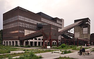
In 1977, at the initiative of various citizens, youth and the local Protestant church Initiative Center Zeche Carl eV was established to run the former colliery as a Cultural Centre. The entire group of buildings are now being conserved.
The reconstructed building has developed as a pan-regional cultural centre offering a diverse programme of concerts, parties, classes, readings, exhibitions workshops etc. It also provides space for other community groups, including Offene Kanal Essen, a public television station.
As a Rock venue, Zeche Carl has hosted numerous bands.
Following the bankruptcy of the original association, Carl Gmbh was set up as nonprofit organisation, and is headed by Marcus Kalbitzer, who followed Kornelia Vossebein in 2020. [1]

The Ruhr, also referred to as Ruhr area, Ruhr district, Ruhr region, or Ruhr valley, is a polycentric urban area in North Rhine-Westphalia, Germany. With a population density of 2,800/km2 and a population of over 5 million (2017), it is the largest urban area in Germany. It consists of several large cities bordered by the rivers Ruhr to the south, Rhine to the west, and Lippe to the north. In the southwest it borders the Bergisches Land. It is considered part of the larger Rhine-Ruhr metropolitan region of more than 10 million people, which is among the largest in Europe.

Essen is the central and, after Dortmund, second-largest city of the Ruhr, the largest urban area in Germany. Its population of 582,415 makes it the fourth-largest city of North Rhine-Westphalia after Cologne, Düsseldorf and Dortmund, as well as the tenth-largest city of Germany. Essen lies in the larger Rhine-Ruhr Metropolitan Region and is part of the cultural area Rhineland. Because of its central location in the Ruhr, Essen is often regarded as the Ruhr's "secret capital". Two rivers flow through the city: in the north, the Emscher, the Ruhr area's central river, and in the south, the Ruhr River, which is dammed in Essen to form the Lake Baldeney (Baldeneysee) and Lake Kettwig reservoirs. The central and northern boroughs of Essen historically belong to the Low German (Westphalian) language area, and the south of the city to the Low Franconian (Bergish) area.

The National Coal Mining Museum for England is based at the site of Caphouse Colliery in Overton, Wakefield, West Yorkshire, England. It opened in 1988 as the Yorkshire Mining Museum and was granted national status in 1995.

Tower Colliery was the oldest continuously working deep-coal mine in the United Kingdom, and possibly the world, until its closure in 2008. It was the last mine of its kind to remain in the South Wales Valleys. It was located near the villages of Hirwaun and Rhigos, north of the town of Aberdare in the Cynon Valley of South Wales.

The Rhine–Herne Canal is a 45.6-kilometre-long (28.3 mi) transportation canal in the Ruhr area of North Rhine-Westphalia, Germany, with five canal locks. The canal was built over a period of eight years and connects the harbour in Duisburg on the Rhine with the Dortmund-Ems Canal near Henrichenburg, following the valley of the Emscher. It was widened in the 1980s. The Rhein-Herne canal ship was designed specifically for this canal; normally of about 1300–1350 ton capacity, it has a maximum draft of 2.50 metres (8.2 ft), a length of approximately 80 metres (260 ft), and maximum beam of 9.50 metres (31.2 ft).

Kiveton Park Colliery was a coal mine in the village of Kiveton Park, near Rotherham, South Yorkshire, England.
The South Yorkshire Coalfield is so named from its position within Yorkshire. It covers most of South Yorkshire, West Yorkshire and a small part of North Yorkshire. The exposed coalfield outcrops in the Pennine foothills and dips under Permian rocks in the east. Its most famous coal seam is the Barnsley Bed. Coal has been mined from shallow seams and outcrops since medieval times and possibly earlier.

The Zollverein Coal Mine Industrial Complex is a large former industrial site in the city of Essen, North Rhine-Westphalia, Germany. It has been inscribed into the UNESCO list of World Heritage Sites since December 14, 2001, and is one of the anchor points of the European Route of Industrial Heritage.
The actual boundaries of the Ruhr vary slightly depending on the source, but a good working definition is to define the Lippe and Ruhr as its northern and southern boundaries respectively, the Rhine as its western boundary, and the town of Hamm as the eastern limit.
Lohberg is one of seven subdivisions of Dinslaken, a city located at the northwestern margin of the Ruhr area. Lohberg is mainly known for its now closed coal mine Zeche Lohberg.
Parsonage Colliery was a coal mine operating on the Lancashire Coalfield in Leigh, then in the historic county of Lancashire, England. The colliery, close to the centre of Leigh and the Bolton and Leigh Railway was sunk between 1913 and 1920 by the Wigan Coal and Iron Company and the first coal was wound to the surface in 1921. For many years its shafts to the Arley mine were the deepest in the country. The pit was close to the town centre and large pillars of coal were left under the parish church and the town's large cotton mills.

Bradford Colliery was a coal mine in Bradford, Manchester, England. Although part of the Manchester Coalfield, the seams of the Bradford Coalfield correspond more closely to those of the Oldham Coalfield. The Bradford Coalfield is crossed by a number of fault lines, principally the Bradford Fault, which was reactivated by mining activity in the mid-1960s.
The Essen-Ruhr-Bochum-Langendreer railway is a railway line in the Ruhr region of the German state of North Rhine-Westphalia. Part of it is now disused.

Dortmund-Barop station is on Barop Marktplatz in the Hombruch district of the city of Dortmund in the German state of North Rhine-Westphalia on the Elberfeld–Dortmund line. The station is currently classified as a category 5 station. It is served by regional services and Rhine-Ruhr S-Bahn line S 5.

Bowen Consolidated Colliery is a heritage-listed former mine at Station Street and Second Avenue, Scottville, Whitsunday Region, Queensland, Australia. It was established in 1919. It is also known as No. 1 Underground Mine and Bowen Consolidated Coal Company Colliery. It was added to the Queensland Heritage Register on 3 December 2009.

The Zeche Neuglück & Stettin in Witten-Muttental is a former mine, also known as the Zeche Stettin & Neuglück. It was created in the Stadtforst Mutteltal as a result of the Niemeyersche Karte, where there is now a fire station and is west of today's Berghauser Straße. The Stettin tunnel is now a component of the Bergbauwanderweg Muttental Muttental Mining trail.
Hapton Valley Colliery was a coal mine on the edge of Hapton near Burnley in Lancashire, England. Its first shafts were sunk in the early 1850s and it had a life of almost 130 years, surviving to be the last deep mine operating on the Burnley Coalfield.
The Ruhr Museum, formerly the Ruhrland Museum, is a diverse natural history and cultural history museum for the Ruhrgebiet in Essen, Germany. The sponsor is the Stiftung Ruhr Museum. Director since 2012 is the historian Heinrich Theodor Grütter.

The Möller Colliery was a coal mine in Gladbeck, North Rhine-Westphalia, Germany, which operated from 1901 until 1967, after which time the site was demolished. It was one of the major coal mining operations in the heavily industrialized region in northwestern Germany during the first two-thirds of the 20th century.
The Ewald Colliery is a disused coal mine in Herten, North Rhine-Westphalia, Germany. Established in 1872, it was one of several major mining sites in the heavily-industrialized Ruhr district in northwestern Germany during the late nineteenth and twentieth centuries. The site eventually ceased operations as a mine in 2001 and has since been converted to commercial space.
Coordinates: 51°29′43″N7°00′43″E / 51.49528°N 7.01194°E
| General | |
|---|---|
| Other | |