
Darien is a coastal town in Fairfield County, Connecticut, United States. With a population of 21,499 and a land area of just under 13 square miles (34 km2), it is the smallest town on Connecticut's Gold Coast. The town is part of the Western Connecticut Planning Region. It has a high rate of marriage, and high average number of children per household.

Long Island Sound is a marine sound and tidal estuary of the Atlantic Ocean. It lies predominantly between the U.S. state of Connecticut to the north and Long Island in New York to the south. From west to east, the sound stretches 110 mi (180 km) from the East River in New York City, along the North Shore of Long Island, to Block Island Sound. A mix of freshwater from tributaries, and saltwater from the Atlantic Ocean, Long Island Sound is 21 mi (34 km) at its widest point and varies in depth from 65 to 230 feet.

Tomales Bay is a long, narrow inlet of the Pacific Ocean in Marin County in northern California in the United States. It is approximately 15 mi (24 km) long and averages nearly 1.0 mi (1.6 km) wide, effectively separating the Point Reyes Peninsula from the mainland of Marin County. It is located approximately 30 mi (48 km) northwest of San Francisco. The bay forms the eastern boundary of Point Reyes National Seashore. Tomales Bay is recognized for protection by the California Bays and Estuaries Policy. On its northern end, it opens out onto Bodega Bay, which shelters it from the direct current of the Pacific. The bay is formed along a submerged portion of the San Andreas Fault.

Port Stephens, an open youthful tide-dominated drowned-valley estuary, is a large natural harbour of approximately 134 square kilometres (52 sq mi) located in the Hunter and Mid North Coast regions of New South Wales, Australia.

The North Shore of Long Island is the area along the northern coast of New York's Long Island bordering Long Island Sound. Known for its extreme wealth and lavish estates, the North Shore exploded into affluence at the turn of the 20th century, earning it the nickname the Gold Coast. Historically, this term refers to the affluent coastline neighborhoods of the towns of North Hempstead and Oyster Bay in Nassau County and Huntington in Suffolk County. Some definitions may also include the parts of Smithtown that face the Sound. The region is also largely coextensive with the Gold Coast region of Long Island, though this region excludes Smithtown, as the easternmost Gold Coast mansion is the Geissler Estate, located just west of Indian Hills Country Club in the Fort Salonga section of Huntington.

Charles Island is a 14-acre island located roughly 0.5 mile (1 km) off the coast of Milford, Connecticut, in Long Island Sound centered at 41°11′28.32″N73°03′18″W.

The Norwalk River is a river in southwestern Connecticut, United States, approximately 21 miles (34 km) long. The word "Norwalk" comes from the Algonquian word "noyank" meaning "point of land".
The Stewart B. McKinney National Wildlife Refuge is a 950-acre (384.5 ha) National Wildlife Refuge in ten units across the U.S. state of Connecticut. Located in the Atlantic Flyway, the refuge spans 70 miles (110 km) of Connecticut coastline and provides important resting, feeding, and nesting habitat for many species of wading birds, shorebirds, songbirds and terns, including the endangered roseate tern. Adjacent waters serve as wintering habitat for brant, scoters, American black duck, and other waterfowl. Overall, the refuge encompasses over 900 acres (364.2 ha) of barrier beach, intertidal wetland and fragile island habitats.

The Cove is a neighborhood located in the southeast corner of Stamford, Connecticut. It is an area of mostly modest homes with some very expensive homes along the shoreline.

The Norwalk Islands are a chain of more than 25 islands amid partly submerged boulders, reefs and mudflats along a six-mile (10 km) stretch and mostly about a mile off the coast of Norwalk, Connecticut, and southwest Westport, Connecticut, in Long Island Sound.

The Long Island Sound link is a proposed bridge or tunnel that would link Long Island, New York, to Westchester County or Connecticut, across Long Island Sound east of the Throgs Neck Bridge. The project has been studied and debated since the mid-20th century. The most recent proposal is a tunnel between Rye, New York, on the mainland and Oyster Bay on the island. Feasibility studies for bridges and tunnels have been conducted for numerous entry points, as listed in the chart below.
Norwalk Harbor is a recreational and commercial harbor and seaport at the estuary of the Norwalk River where it flows into Long Island Sound in Norwalk, Connecticut, United States.
Hay Island is a small peninsula located off the Darien, Connecticut, shore of Long Island Sound. Its north shore is located on Ziegler's Cove. A small road connects the island with Long Neck Point Road. There are two structures on Hay Island. One was the home of the late William Ziegler III, a founder of the Maritime Aquarium at Norwalk.
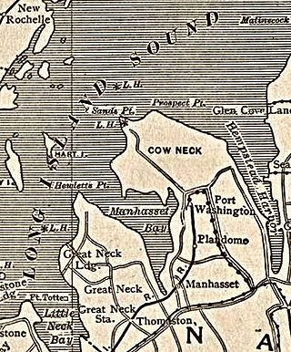
Manhasset Bay, New York, is an embayment in western Long Island off Long Island Sound.
Cuties Island is a small, formerly inhabited island off the coast of Stamford, Fairfield County, Connecticut.

Jones Inlet is located at the westernmost end of the 17-mile (27 km) long Jones Beach barrier island that runs along Long Island's south shore. The inlet separates Jones Beach State Park's West End from the community of Point Lookout and connects South Oyster Bay with the Atlantic Ocean. In 2006, the inlet handled approximately 10,000 tons of commercial tonnage.

The Church of St. Dominic is a Roman Catholic parish church in the Roman Catholic Diocese of Rockville Centre, in Oyster Bay, New York. The parish was founded in the late nineteenth century.

The Smith House is a work of contemporary architecture designed by Richard Meier, a well-known architect born in 1934 who led the avant-garde modern architecture movement of the 1960s. The Smith House was planned starting in 1965 and completed in 1967 in Darien, Connecticut, and overlooks the Long Island Sound from the Connecticut coast. The 2,800 square-foot home has been featured in numerous books and has won various prestigious awards.

Nepean Bay is a bay located on the north-east coast of Kangaroo Island in the Australian state of South Australia about 130 kilometres south-south-west of Adelaide. It was named by the British navigator, Matthew Flinders, after Sir Evan Nepean on 21 March 1802.