
The Netherlands is both a very densely populated and a highly developed country in which transport is a key factor of the economy. Correspondingly it has a very dense and modern infrastructure, facilitating transport with road, rail, air and water networks. In its Global Competitiveness Report for 2014-2015, the World Economic Forum ranked the Dutch transport infrastructure fourth in the world.

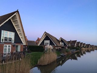
Aalsmeer is a municipality and a town in the Netherlands, in the province of North Holland. Its name is derived from the Dutch for eel (aal) and lake (meer). Aalsmeer is bordered by the Westeinderplassen lake, the largest open water of the Randstad, and the Ringvaart Canal. The town is located 13 km (8 mi) southwest of Amsterdam.

Haarlemmermeer is a municipality in the west of the Netherlands, in the province of North Holland. Haarlemmermeer is a polder, consisting of land reclaimed from water. The name Haarlemmermeer means 'Haarlem's lake', referring to the body of water from which the region was reclaimed in the 19th century.

Hoofddorp is the main town of the municipality of Haarlemmermeer, in the province of North Holland, the Netherlands. In 2021, the population was 77,885. The town was founded in 1853, immediately after the Haarlemmermeer had been drained.
De Vink is a railway station in the Netherlands. It is located near the former hamlet of De Vink, currently a part of Leiden.
Nieuw-Vennep is a town in the Dutch province of North Holland. It is located near the capital city Amsterdam as well as Amsterdam Airport Schiphol. It has a population of 31,415 (2021), and is a part of the municipality of Haarlemmermeer, which ranks in top 15% of Dutch municipalities by income level.
The Randstad is a roughly crescent- or arc-shaped conurbation in the Netherlands, that houses almost half the country's population. With a central-western location, it connects and comprises the Netherlands' four biggest cities, their suburbs, and many towns in between, that all grew and merged into each other. Among other things, it includes the Port of Rotterdam, the Port of Amsterdam, and Amsterdam Airport Schiphol. With a population of approximately 8.4 million people it is one of the largest metropolitan regions in Europe, comparable in population size to the Rhine-Ruhr metropolitan region or the San Francisco Bay Area, and covers an area of approximately 11,372 km2 (4,391 sq mi). The Randstad had a gross regional product of €397 billion in 2017, making it the third most productive region in the European Union, behind the Paris metropolitan area and the Rhine-Ruhr metropolitan region. It encompasses both the Amsterdam metropolitan area and Rotterdam–The Hague metropolitan area. It is part of the larger Blue Banana megalopolis.

The HSL-Zuid, is a 125 kilometre-long Dutch high-speed railway line running between the Amsterdam metropolitan area and the Belgian border, with a branch to Breda, North Brabant. Together with the Belgian HSL 4 it forms the Schiphol–Antwerp high-speed railway. Originally scheduled to be in service by 2007, the first public operations began on 7 September 2009, after a ceremony on 6 September.

Amsterdam Zuid is a railway station situated in the borough of Amsterdam-Zuid in Amsterdam, Netherlands. For a number of years, it was named Amsterdam Zuid WTC, in reference to the neighbouring World Trade Center Amsterdam. During 2006, in conjunction with the rapid development of the area surrounding the station, the station was enlarged and the reference to the WTC was formally dropped from the name.

Amsterdam Bijlmer ArenA, previously named Amsterdam Bijlmer (1971–2006), is a railway station in the Bijlmermeer neighbourhood of stadsdeel (borough) Amsterdam-Zuidoost in Amsterdam, Netherlands. The station has five platforms and eight tracks; two for the Amsterdam Metro and six train tracks, along with a bus station. Train services are operated by Nederlandse Spoorwegen.

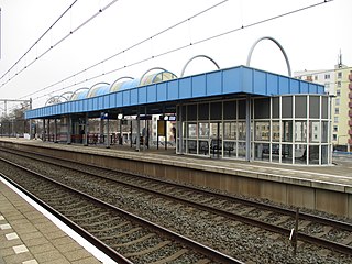
Hoofddorp is a railway station in Hoofddorp, Netherlands located on the Weesp–Leiden railway.

Nieuw-Vennep is a railway station in Nieuw-Vennep, Netherlands located on the Weesp–Leiden railway. It the second station in Nieuw Vennep; there existed an earlier one on the Hoofddorp–Leiden railway. This station opened in 1912 and closed in 1936.

The Weesp–Leiden railway is a railway line in the Netherlands which runs between the cities of Weesp and Leiden; the line also passes through and serves Amsterdam Airport Schiphol.

Den Haag Laan van NOI railway station is a railway station in the Netherlands, on the border between The Hague and the town of Voorburg. It is served by the Nederlandse Spoorwegen and by the RandstadRail light-rail network. The station is named after the road on which it is located, Laan van Nieuw Oost-Indië, which literally translates as New East Indies Avenue, but probably refers to a former inn called Nieuw Oosteinde.
The A5 motorway is a motorway in the Netherlands. With a length of 17 kilometres (11 mi), it is one of the shortest motorways in the country.

Sassenheim is a railway station in Sassenheim, Netherlands and is situated on the Schiphollijn. Construction began in 2009 and the station was opened on 9 December 2011, while train services started on 11 December 2011. The station has 2 platforms.

The Amsterdam–Schiphol railway is an important 17 kilometre long railway line in the Netherlands that connects Amsterdam with Amsterdam Airport Schiphol, and allows trains to continue to Leiden, The Hague, and Rotterdam.
The main public transport in the Netherlands for longer distances is by train. Long-distance buses are limited to a few missing railway connections. Regional and local public transport is by bus, and in some cities by metro and tram. There are also ferries.

Amstelveenseweg is an Amsterdam Metro station in the south of Amsterdam, Netherlands. The station opened in 1997 and is served by line 50 and 51.
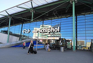
Schiphol Airport railway station is a major passenger railway station in Haarlemmermeer, Netherlands, beneath the terminal complex of Amsterdam Airport Schiphol, operated by the Nederlandse Spoorwegen. The station's six platforms are accessible via twelve escalators and three elevators located in the main concourse of the airport. The original station was opened in 1978, and the current station in 1995. It connects the airport to Amsterdam and other cities in the Netherlands, as well as to Belgium and France.

