A40 road

Last updated

UK road A40.svg
A40
A40 road map.png
Holborn Viaduct December 2005.jpg
Holborn Viaduct carries the A40
Route information
Part of Tabliczka E30.svg E30
Maintained by National Highways, English local authorities, South Wales Trunk Road Agent and North & Mid Wales Trunk Road Agent
Length261.2 mi [1] [2] [3]  (420.4 km)
Major junctions
East endUK road A1.svgUK road A1121.svg A1  / A1121 in City of London
Major intersections
West end Goodwick (Fishguard)
Location
Country United Kingdom
CountiesEngland:
Greater London, Buckinghamshire, Oxfordshire, Gloucestershire, Herefordshire
Wales:
Monmouthshire, Powys, Carmarthenshire
Primary
destinations
London, Beaconsfield, High Wycombe, Oxford, Cheltenham, Gloucester, Ross-on-Wye, Monmouth, Abergavenny, Brecon, Llandovery, Llandeilo, Carmarthen, Haverfordwest, Fishguard
Road network
UK road A39.svg A39 UK road A41.svg A41

The A40 is a trunk road which runs between London and Goodwick (Fishguard), Wales, and officially called The London to Fishguard Trunk Road (A40) in all legal documents and Acts. Much of its length within England has been superseded by motorways, such as the M40, and has lost its trunk road status, though it retains it west of Gloucester, including its length within Wales. It is approximately 260 miles (420 km) long. The eastern section from Denham, Buckinghamshire to Wheatley, Oxfordshire is better served by the M40 and its former function of linking London with Cheltenham and Gloucester has been taken by the M4, A419 and A417 via Swindon.

History

The A40 1923 route was from the City of London to Fishguard. The road still begins and ends in the same places, but a number of changes have been made to its route. [4]

The first change dates from 1935, between Ross-on-Wye and Abergavenny. The original route of the A40 was via Skenfrith, avoiding Monmouth; this road was renumbered the B4521. The A40 was rerouted via Raglan; between Ross and Raglan it replaced part of the A48, between Raglan and Llanvihangel-nigh-Usk it replaced the B4234, and between Llanvihangel and Abergavenny it replaced part of the A471.

Subsequently, the A40 was rerouted within west London. Western Avenue dates from the 1930s, but was originally opened as the A403. After the Second World War, the A40 was rerouted along part of the A219 (west of Notting Hill) and Western Avenue. The old route (via Acton, Ealing, Southall, Hayes, Hillingdon and Uxbridge) was renumbered the A4020.

Initially, the A40 went through the centre of Oxford, via Headington, Magdalen Bridge, the High Street, Carfax and Botley, and over the Swinford Toll Bridge to Eynsham. It was rerouted in the 1930s to follow the first section of the Oxford Ring Road to the north of the city, and then followed a direct line to bypass Eynsham. The old route became part of the A420 to Botley, and the section between Botley and Eynsham was renumbered the A4141, [5] renumbered again in the 1960s to the B4044.

Route

Central London – Denham

In central London it is High Holborn and then Oxford Street. At Marble Arch it joins the A5 Edgware Road as far as the Marylebone Flyover to become Westway (formerly classified A40(M) as an elevated motorway, it is now an A-road) then meets Western Avenue. For the greater part, this section is six lanes, otherwise four lanes. With two exceptions, Western Avenue forms a grade-separated motorway standard dual-carriageway between Paddington and the M40 motorway. The two at-grade intersections are Gypsy Corner and Savoy Circus; both of which are traffic light controlled. At Denham Roundabout, the six lane Western Avenue flows into the M40.

Denham – Oxford

The A40 branches off the Denham roundabout to run as a dual carriageway. After the junction with the A413, the A40 follows the same route as the M40 as a single carriageway, passing through Beaconsfield and High Wycombe. Beyond Stokenchurch the road is much quieter; when meeting the B4009 and A329 those roads have priority. Approaching Oxford, the A40 becomes a busy dual carriageway, carrying traffic from the M40 to Oxford and beyond. The road forms the northern section of the Oxford Ring Road, crossing the A44 and the A34. In Oxford, it passes the Thornhill Park and Ride, where the OxfordTube, The Airline to Heathrow & Gatwick, & Oxford Park and Ride buses stop.

Oxford – Cheltenham (M5)

The A40 passes under the A34, reverting to single carriageway for 10 miles (16 km) until the dual carriageway just east of Witney with a grade-separated junction. The dual carriageway finishes at a roundabout. For the rest of Oxfordshire and Gloucestershire until Cheltenham, other than for a few short stretches, the road is single carriageway. A height of 820 feet (250 m) above sea level is located 3 miles (4.8 km) west of the A429 junction. Before Andoversford the A436 breaks off to the west to try to take traffic away from descending into the centre of Cheltenham itself. The road travels through Cheltenham town centre along at least two parallel routes (neither is part of a one-way system: Sandford Road and Montpellier Terrace make up one part, Thirlestaine Road and Suffolk Road the other). Becoming a dual carriageway, it passes GCHQ in Cheltenham and the three-level stacked roundabout junction with the M5 motorway. In February 2015, the Witney Oxford Transport Group proposed the reopening of Yarnton railway station as an alternative to improvements to the A40 road proposed by Oxfordshire County Council. [6] [7]

Cheltenham (M5) – Abergavenny

The A40 is the Gloucester bypass, most of which is dual carriageway. The junction with the A48 to Chepstow is at Highnam. For the remainder of Gloucestershire, and a part of Herefordshire, the road is single carriageway until Ross-on-Wye. There it connects with the M50 motorway, and forms part of the high quality dual carriageway between South Wales and the English Midlands. From Ross-on-Wye to Monmouth the road follows the Wye Valley, an Area of Outstanding Natural Beauty, crossing the Wales–England border a mile east of Monmouth. Just west of Monmouth are twin tunnels; these are the only tunnels on the A40. Near Raglan, the A40 has a grade separated junction with the A449. The A40 continues as a dual carriageway to Abergavenny.

Abergavenny – M50 junctions

A40 (T)
Eastbound exitsJunctionWestbound exits
The Midlands Worcester ( M50 )
Ross-on-Wye
RoundaboutRoss-on-Wye
The MIDLANDS Worcester (M50)
Hereford A49
Ross-on-Wye B4260
Wilton RoundaboutRoss-on-Wye B4260
Hereford A49
Goodrich Goodrich JunctionGoodrich
Hereford A4137
Goodrich B4229
Old Ross Road JunctionHereford A4137
Goodrich B4229
Whitchurch, Symond's Yat (West)Whitchurch JunctionWhitchurch, Symond's Yat (West)
Exit only
Whitchurch
Whitchurch South JunctionNo exit or access
No exit or accessOak House JunctionCrocker's Ash, Doward
Monmouth A466
Chepstow (A466), Forest of Dean (A4136) A40
Old Dixon RoundaboutMonmouth A466
Monmouth A466Wye Bridge JunctionChepstow (A466), Forest of Dean (A4136)
Monmouth, Trelleck B4293Monnow Bridge JunctionMonmouth, Trelleck B4293
No access or exitMitchel Troy JunctionAccess only
Newport A449 Raglan InterchangeNewport, Cardiff ( M4 ) A449
Abergavenny (A40), Raglan, Mitchel Troy Raglan JunctionRaglan
Mitchel Troy, Dingestow
Clytha
Raglan
Gwehelog
Raglan RoundaboutRaglan
Gwehelog
Clytha
Hereford A465
Usk, Clytha B4598
Ysbytty Fields RoundaboutNo access or exit
Newport A4042
Merthyr Tydfil A465
Newport A4042
Merthyr Tydfil A465
Hereford A465

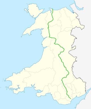
Abergavenny – Carmarthen

At Abergavenny is the A40 junction with the Heads of the Valleys road, (A465) and the A4042. Now the A465 becomes the primary route between the Midlands to the South Wales Valleys and Swansea; there is a dual-carriageway route to Carmarthen via the A465, M4 and A48.

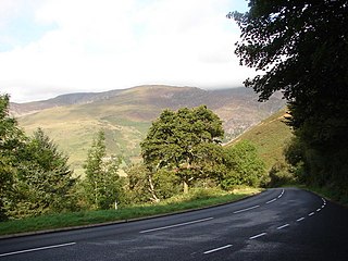
The A40 becomes single carriageway and continues through Abergavenny, following the north side of the Usk valley through the eastern part of the Brecon Beacons National Park until Brecon. At Bwlch between Abergavenny and Brecon, the A40 is 660 feet (200 m) above sea level. The A40 is dualled for over 1.5 miles (2.4 km) as it approaches a junction east of Brecon with the A470 north, which is the main north–south road through mid-Wales. Continuing as a dual carriageway, the A40 and A470 concurrent bypass Brecon to the south, crossing the River Usk here. At the western end of the bypass is a further junction with the A470 south. Beyond this point the A40 continues as a single carriageway, now south of the River Usk, and roughly follows the northern edge of the Brecon Beacons National Park. A height of 820 feet (250 m) above sea level is located less than 1 mile (1.6 km) east of Trecastle. In Llandovery the road crosses the Heart of Wales railway and the River Tywi; the road, railway and river then run parallel until Llandeilo, where the National Park ends and the railway turns south. The A40 continues west along the Tywi valley to Carmarthen where as a dual carriageway it forms the eastern bypass, meeting the terminus of the A48 at Pensarn. Here the A40 returns to being a primary route westwards.

Carmarthen – Fishguard

At Carmarthen the A40 crosses the River Tywi twice with two 90-degree junctions and continues on 10 miles (16 km) of dual carriageway as far as St. Clears, where the dual carriageway ends at the junction with the A477 trunk road. Now the A40 is a mixture of 2 or 3 lane single-carriageway to Haverfordwest and Fishguard. This section of road is controlled by the Welsh Government (formerly 'Welsh Assembly Government'), which describes it as "one of the lowest standard sections of the Trans European Road Network in the United Kingdom". [8]

St Clears to Haverfordwest dualling There were plans in 2002 for a major improvement of the 23-mile stretch between St Clears and Haverfordwest which included upgrading to a dual carriageway; described as an extension of the national motorway network to the West Wales coast by virtue of the route from the M4 motorway being entirely dual carriageway. [9] The £60 million scheme was subject to a European Environmental Assessment. Within a couple of years, the project appeared to be dying a very quiet death, causing local newspapers to report it being an election stunt for the two marginal constituencies that would best benefit from the improvements. The following Welsh elections saw both constituencies change the party of majority. The political party at the centre of the row instead directed the project deferment to damning environmental statements by Friends of the Earth Cymru. [10] [11] The scheme was officially scrapped in 2008 after a Welsh Assembly committee decided to abandon the proposals. Instead, it recommended upgrades to the existing route including bypasses around Robeston Wathen and Llanddewi Velfrey using a three-lane option. This was welcomed by the Friends of the Earth, saying "The dual carriageway on the A40 would increase traffic levels, increase the emission of greenhouse gases, it would be harmful for the environment, it would be hugely expensive. That money would be better spent on improving public transport, on health, on education, there's no need for it. We think the assembly committee has come to the right decision". [12]

Whitland Bypass The last improvement to the A40 on this section prior to the Welsh Assembly Government having the devolved responsibility for this road was a 4.1 kilometres (2.5 mi) £8 million bypass around Whitland. Constructed in 1994, the road started east of Black Bridge on the original A40, then running north of the town before to a new roundabout just west of Llain Cottage. The Secretary of State for Wales was asked a written question by Rhodri Morgan about adding a second carriageway to the Whitland bypass scheme, to which John Redwood replied "There are no proposals to add a second carriageway to the Whitland bypass. The design capacity of a single carriageway two-lane highway is more than adequate to cater with the anticipated traffic flows for the foreseeable future." [13]

Llanddewi Velfrey Bypass A new bypass has been granted approval by the Welsh Assembly Government at Llanddewi Velfrey in Pembrokeshire. The scheme would improve the A40 between Llanddewi Velfrey and Penblewin, to the west of St Clears and meet the aim of the targeted investment in infrastructure along the east–west road corridor in south Wales. [14] From the east, it is proposed that a roundabout would be created just north of Glenfield Farm, where the straight section from St Clears ends at Bethel Chapel, and then take a new route north-west of the town of Llanddewi Velfrey, south-west over Pentroydin Fawr and Penttroydin Fech farms with cattle underpasses, a new underpass beneath the existing Llanddewi Velfrey to Llanfallteg road, before going over the original A40 at Ffynnon Wood. To the west of Ffynnon Wood, the road would then cross back over the original A40 to the east of Henllan Lodge in a way to maintain the tree lined avenue to Henllan, then run parallel to the A40 on the north side of the existing A40 to a new roundabout at Penblewin and the junction with the A478. [15]

This was originally known as the Blue and Purple routes during the Consultation in 2006 [16] for which 75% preferred the blue route, and only 20% preferred the red route. 54% felt the section from Ffynnon Wood and Penblewin Roundabout needed improvement, with both orange and purple routes preferred by 42% of the respondents. Welsh Water/Dwr Cymru expressed concerns with the red route affecting water mains and sewers, and Henllanfallteg Community Council felt the red route would not improve the quality of life in Llanddewi Velfrey. Pembrokeshire County Council expressed concerns that the route planned was a single carriageway, and that within seven years, a dual carriageway would be required.

Robeston Wathen Bypass A new bypass has been constructed between Penblewin and Slebech Park making the road straighter and with a '2+1' road layout to help improve overtaking opportunities. [17]

Starting to the west of Toch Lane (approx. 2 kilometres (1.2 mi) east of Slebech), the route travels eastwards for 4.6 kilometres (2.9 mi), passing 200 metres (660 ft) south of Robeston Wathen, and ending 0.5 kilometres (0.31 mi) east of the village, just west of Flimstone Lane.

Construction started on the route in February 2009, with the works completed and the new road opening 1 March 2011. The road was built by Costain. The scheme was nearly £14 million over the initial budget of £27.6 million, eventually costing £41.4 million. The Welsh Assembly Government explains this increase as being the result of inflation and land costs, saying the original budget did not include either, as well as additional statutory procedures, additional works following some design standards, and the increase in VAT. [18]

The Kell The Kell is located on a section of the A40 that forms a north–south corridor between Fishguard, 17 kilometres (11 mi) to the north and Haverfordwest, 7.5 kilometres (4.7 mi) to the south, close to Treffgarne and Spittal. The improvement saw about 0.48 kilometres (0.30 mi) of new trunk road commencing at a point on the trunk road approximately 622 metres south of the centreline of the junction of the A40 trunk road with the C3059 road to Spittal and extending in a generally northerly direction to a point approximately 112 metres south of the junction of the trunk road with the C3059 road to Spittal. [19] This resulted in the road being rerouted through pasture to the east of the original road, taking a right hand bend about 160 metres (520 ft) south of The Old Mill, taking a 5.5% gradient, and rejoining the original road 210 metres (690 ft) north of The Kell. The original road has subsequently been converted to an access road for The Old Mill, Beavers Lodge and The Kell, accessing the new road at The Old Mill.

Fishguard Bypass The Fishguard Bypass was planned to provide a more direct route with greater capacity to the Port of Fishguard at Goodwick avoiding the town centre of Fishguard. It was constructed during the late 1990s and opened in 2000. It takes the form of a three-lane carriageway on an approx. 10% gradient around the western edge of Fishguard. It runs from its highest point at Rafael roundabout 1 km south of Fishguard town in a generally northerly direction to its lowest point at Windy Hall roundabout where it rejoins the old A40 route at Gasworks Hill. The bypass is concurrent with a section of the A487 trunk road with the A40 dominant. [20] [21]

Junction list

A40

CountyLocationmi [1]

[2]

[3]
kmDestinationsNotes
Greater London City of London 0.00.0 Goswell Road (A1 north) / London Wall (A1121 east) Angel, Islington Eastern terminus; southern terminus of A1; western terminus of A1211
City of London-Camden boundary0.60.97New Fetter Lane (A4 west) / Hatton Garden (B521) / Charterhouse StreetEastern terminus of A4
Camden 1.21.9 Theobalds Road (A401 east)Eastern terminus of A401 concurrency
1.32.1 Kingsway / Southampton Row (A4200) No access from A40 east to A4200, from A4200 south to A40, or from A4200 north to A40 east
Camden-Westminster boundary1.6–
1.7
2.6–
2.7
UK road A400.svgUK road A501.svg A400 (Bloomsbury Street / Tottenham Court Road / Charging Cross Road) / Shaftesbury Avenue (A401 west) / A501  Camden Town, West End, Westminster West End and Westminster signed westbound only; western terminus of A401 concurrency
Westminster 2.23.5Regent Street (A4201)No right-hand turns
2.74.3Orchard Street (A41 west) / North Audley StreetEastern terminus of A41
2.84.5Portman Street (A4380 north) / Park StreetSouthern terminus of A4380
3.04.8UK road A402.svgUK road A4.svgUK road A3.svg Ring Road south (Park Lane / A4202 south) / A402 west (Bayswater Road) to A4  / A3  Westminster, Notting Hill, Knightsbridge, Victoria Knightsbridge and Victoria signed westbound only; eastern terminus of A5 / Ring Road concurrency; southern terminus of A5; eastern terminus of A402
3.15.0Wigmore Street (A5204 east) / Seymour StreetNo access from A40 to A5204; western terminus of A5204
3.55.6Old Marylebone Road (A501 east) / Sussex Gardens (A4209 south-west)No access from A40 to A501, from A40 east to A4209, from A501 to A40 west, or from A4209 to A40 east; north-eastern terminus of A4209
3.65.8A40 jumps from concurrency with UK road A5.svg A5 to the Westway without any direct connection ^
4.77.6To Ring Road south - West End, Paddington Grade-separated junction; eastbound exit and westbound entrance
Kensington and Chelsea-Hammersmith and Fulham borough boundary6.0–
6.3
9.7–
10.1
UK road A3220.svg A3220 south Hammersmith, Shepherd's Bush, Earl's Court, Westminster Grade-separated junction; Westminster signed eastbound only
Hammersmith and Fulham 6.510.5UK road A219.svg A219  Harlesden, White City Grade-separated junction; Eastbound exit and westbound entrance
Ealing 8.1–
8.3
13.0–
13.4
UK road A4000.svg A4000  / B4492 Harlesden, Willesden, Acton, Park Royal
9.515.3 Park Royal (central)Grade-separated junction; eastbound exit only
9.4–
10.0
15.1–
16.1
UK road A406.svgUK-Motorway-M1.svgUK-Motorway-M4.svgUK road A41.svgUK road A1.svg A406 (North Circular) / M1  / M4  / A41  / A1  Wembley, Ealing
10.9–
11.5
17.5–
18.5
Perivale Grade-separated junction
11.9–
12.3
19.2–
19.8
UK road A4127.svg A4127  Harrow, Sudbury, Greenford Grade-separated junction
13.3–
13.9
21.4–
22.4
UK road A312.svgAircraft Airport ecomo.svg A312  Heathrow Airport, Hayes, Southall, Yeading, Northolt Grade-separated junction; Heathrow, Hayes, Southall and Yeading signed westbound only, Northolt eastbound only
Hillingdon 14.4–
14.9
23.2–
24.0
UK road A4180.svgAircraft Airport ecomo.svg A4180  Ruislip, Heathrow Airport, Hayes, Southall, Yeading Grade-separated junction; Ruislip signed westbound only, Heathrow, Hayes, Southall and Yeading eastbound only
16.3–
17.2
26.2–
27.7
UK road A437.svg A437  / B466 Hillingdon, Ruislip, Ickenham Grade-separated junction
17.5–
17.9
28.2–
28.8
B467 Uxbridge, Harefield, Ickenham, Ruislip Grade-separated junction; Ruislip signed eastbound only
Buckinghamshire Denham 18.5–
19.1
29.8–
30.7
UK-Motorway-M40.svgUK-Motorway-M25.svg M40 north-west to M25  Oxford, Birmingham, Beaconsfield, Watford
UK road A4020.svg A4020 east (Oxford Road) Uxbridge, Denham
UK road A412.svg A412 south (Denham Road) Slough
Birmingham and Beaconsfield signed westbound only, Watford eastbound only; eastern terminus of A412 concurrency; western terminus of A4020
19.731.7UK road A412.svg A412 north (Denham Avenue) Rickmansworth, Higher Denham, Denham Green Western terminus of A412 concurrency
20.633.2UK road A413.svg A413 north (Amersham Road) Amersham, The Chalfonts Southern terminus of A413
Beaconsfield 25.541.0UK road A355.svgUK-Motorway-M40.svgUK-Motorway-M25.svg A355 to M40  / M25  Heathrow Airport, Slough, Amersham, London, Wycombe London and Wycombe signed westbound only
Loudwater 28.746.2UK-Motorway-M40.svg M40 east London, Flackwell Heath
UK road A4094.svg A4094 south Maidenhead, Bourne End, Wooburn Green
Flackwell Heath signed westbound only; M4 junction 3; northern terminus of A4094
High Wycombe 31.751.0UK road A404.svgUK-Motorway-M4.svgUK-Motorway-M40.svg A404 to M4  / M40  Maidenhead, Marlow, Amersham
32.151.7UK road A4128.svg A4128 north (Arch Way) Great Missenden Southern terminus of A4128
High Wycombe-West Wycombe boundary33.553.9UK road A4010.svgUK-Motorway-M40.svgUK road A404.svg A4010 south (Chapel Lane) to M40  / A404  Marlow Information signed eastbound only; eastern terminus of A4010 concurrency
West Wycombe 34.154.9UK road A4010.svg A4010 north (Bradenham Road) Aylesbury, Princes Risborough Western terminus of A4010 concurrency
Oxfordshire Great Haseley-Great Milton-Tiddington-with-Albury boundary47.676.6UK road A329.svgUK-Motorway-M40.svg A329 (Rycote Lane) to M40 south London, Wycombe, Wallingford, Thame, Stadhampton, Moreton Brief concurrency
Great Milton-Tiddington-with-Albury boundary49.179.0UK road A418.svg A418 north-east (Oxford Road) Aylesbury, Tiddington Tiddington signed eastbound only; south-western terminus of A418
49.7–
50.3
80.0–
81.0
UK-Motorway-M40.svg M40  London, High Wycombe, Birmingham, Banbury M40 junctions 8-8A
Wheatley 51.983.5 Wheatley, Holton, Waterperry Grade-separated junction; no westbound exit
Headington 54.687.9UK road A4142.svgUK road A420.svg A4142 south (Ring Road) / A420 west (London Road) / Bayswater Road City centre, Cowley, Headington, Barton Northern terminus of A4142; eastern terminus of A420
Marston 56.390.6 Marston, Elsfield Grade-separated junction
Cutteslowe 58.393.8UK road A4165.svg A4165 (Banbury Road) Summertown, Kidlington, Gosford
58.794.5UK road A44.svgUK road A34.svgUK-Motorway-M40.svgUK road A420.svg A44 west (Ring Road) / Woodstock Road (A4144 south) / Five Mile Drive to A34  / M40  / A420  Midlands, Evesham, Newbury, Oxford city centre, Wolvercote, Oxford Airport Swindon signed eastbound only; eastern terminus of A44; northern terminus of A4144
South Leigh-Witney boundary66.2106.5B4022 Witney EastGrade-separated junction; westbound exit and eastbound entrance
Witney-Ducklington boundary68.0–
68.4
109.4–
110.1
UK road A415.svgUK road A4095.svg A415 to A4095  Witney, Abingdon, Faringdon Grade-separated junction; To A4095 and Faringdon signed westbound only
Brize Norton-Minster Lovell boundary70.8113.9B4477 Carterton, RAF Brize Norton, Minster Lovell Grade-separated junction; westbound exit and eastbound entrance
Burford 74.8120.4UK road A361.svgUK road A424.svg A361 (The Hill) to A424  Lechlade, Chipping Norton, Stow, Burford, Faringdon Faringdon signed eastbound only
Gloucestershire Northleach with Eastington-Hampnett boundary83.9135.0UK road A429.svg A429  Cirencester, Stow, Northleach, Bibury, Turkdean, Bourton
Shipton 89.9144.7UK road A436.svgUK road A417.svg A436 west / Shipton to A417  Gloucester, Kilkenny Eastern terminus of A436 concurrency
Andoversford 90.7146.0UK road A436.svg A436 east Stow-on-the-Wold, Bourton-on-the-Water Western terminus of A436 concurrency
Charlton Kings-Cheltenham boundary95.8154.2UK road A435.svg A435 south (Cirencester Road) / Haywards Road Cirencester, Seven Springs, Colesbourne Information signed eastbound only; eastern terminus of A435 concurrency
Cheltenham 96.1154.7UK road A435.svg A435 north (London Road) to B4632 Cheltenham town centre, Evesham, Broadway, Prestbury, Winchcombe Information signed westbound only; western terminus of A435 concurrency
97.0156.1UK road A46.svg A46 (Bath Road) Stroud, Leckhampton, Shurdington, Birdlip
98.8159.0Princess Elizabeth Way (A4013 north) - Swindon Village Southern terminus of A4013
BadgeworthChurchdown boundary100.1–
100.7
161.1–
162.1
UK-Motorway-M5.svg M5  The South West, Midlands, Tewksbury, Bristol The South West and Midlands signed westbound only; Tewksbury and Bristol eastbound only; M5 junction 11
Gloucester UK road A417.svgAircraft Airport ecomo.svg A417 south-east / B4063 (Cheltenham Road) Cirencester, Hucclecote, Longlevens, Churchdown, Innsworth Airport signed eastbound only
104.5168.2UK road A38.svg A38 (Tewksbury Road) Gloucester, Tewksbury, Twigworth, Longford
105.8170.3UK road A417.svgUK-Motorway-M50.svg A417 to M50  Ledbury, Gloucester, Hartpury, Maisemore
Highnam 107.3172.7UK road A48.svg A48 west Chepstow, Westbury-on-Severn, Minsterworth Eastern terminus of A48
Huntley 112.3180.7UK road A4136.svgUK road A466.svg A4136 west (Longhope Road) to A466  Monmouth, Chepstow, Cinderford, Mitcheldean To A466, Monmouth, and Chepstow signed westbound only; eastern terminus of A4136
Herefordshire Ross-on-Wye 121.4195.4UK road A449.svgUK-Motorway-M50.svg A449 north / Ledbury Road to M50  Midlands, Worcester, Ross-on-Wye Eastern terminus of A449 concurrency
Wilton 122.8197.6UK road A49.svg A49 north / B4260 (Wilton Road) Hereford, Ross-on-Wye, Wilton Wilton signed eastbound only; southern terminus of A49
Whitchurch 127.6–
127.7
205.4–
205.5
UK road A4137.svg A4137 to B4229 Hereford, Goodrich, Symonds Yat (east)Grade–separated junction; southern terminus of A4137
HerefordshireMonmouthshire county boundary GanarewMonmouth boundary130.5210.0 England–Wales border
Monmouthshire Monmouth 131.8–
132.4
212.1–
213.1
UK road A466.svgUK road A4136.svg A466 to A4136  Monmouth, Chepstow, Forest of Dean
132.9213.9B4293 to B4233 Monmouth, Trellech, Rockfield Grade-separated junction; To B4233 and Rockfield signed westbound only; no westbound entrance
Mitchel TroyRaglan boundary138.8–
139.2
223.4–
224.0
UK road A449.svgUK-Motorway-M4.svg A449 south to M4  Newport, Cardiff Grade-separated junction; Cardiff signed westbound only; western terminus of A449 concurrency
Llanfoist FawrAbergavenny boundary147.6–
147.9
237.5–
238.0
UK road A465.svgUK road A4042.svg A465 (Heads of the Valleys Road) / A4042 south Merthyr Tydfil, Hereford, Newport, Pontypool Pontypool signed westbound only; northern terminus of A4042
Abergavenny 149.5240.6UK road A4143.svgUK road A465.svg A4143 south / MT Street to A465  Llanfoist, Merthyr Northern terminus of A4143
Powys Crickhowell 155.2249.8UK road A4077.svg A4077 south (New Road) Llangattock, Gilwern Northern terminus of A4077
Cwmdu 156.7252.2UK road A479.svgUK road A470.svg A479 north to A470  Builth Wells, Tretower, Cwmdu, Talgarth Southern terminus of A479
Llanfrynach 166.7268.3 Llanfrynach, Groesffordd, Llangors, Pencelli Grade–separated junction
Brecon 167.4269.4UK road A470.svg A470 north / B4601 Builth Wells, Brecon Eastern terminus of A470 concurrency
169.8273.3UK road A470.svg A470 south / B4601 Cardiff, Llanfaes Western terminus of A470 concurrency
Sennybridge 177.2285.2UK road A4067.svg A4067 south Ystradgynlais, Swansea Northern terminus of A4067
Carmarthenshire Llandovery 189.7305.3UK road A4069.svg A4069 south (Broad Street) Llangadog Northern terminus of A4069
189.9305.6UK road A483.svg A483 north (New Road) Builth Wells Eastern terminus of A483 concurrency
Llanwrda 193.9312.1UK road A482.svg A482 north-west Lampeter, Pumsaint South-eastern terminus of A482
Llansadwrn 196.3315.9UK road A4069.svg A4069 (Station Road) Llangadog, Brynamman, Bethlehem
Manordeilo and Salem 201.5324.3UK road A483.svgUK-Motorway-M4.svg A483 south (Rhosmaen Street) to M4  Llandeilo, Swansea Western terminus of A483 concurrency
Carmarthen 214.8345.7UK road A485.svgUK road A484.svgUK traffic sign 827.2.svg A485 north to A484  Lampeter, Cardigan Southern terminus of A485
Llangunnor 216.2347.9UK road A484.svg A484 north / B4300 (Heol Llangynnwr) Carmarthen town centre, Llangunnor Eastern terminus of A484 concurrency
216.7348.7UK road A48.svgUK road A484.svgUK-Motorway-M4.svg A48 east / A484 south to M4  Swansea, Llanelli, Burry Port, Kidwelly Western terminus of A484 concurrency; western terminus of A48
Carmarthen 217.2349.5UK road A4242.svg A4242 east Town centre Western terminus of A4242
217.6–
217.8
350.2–
350.5
B4312 Johnstown Grade-separated junction; no eastbound exit
218.4–
218.5
351.5–
351.6
Llanllwch to B4312 Johnstown Grade-separated junction; To B4312 and Johnstown signed eastbound only
St Clears 225.5–
225.9
362.9–
363.6
UK road A477.svgUK road A4066.svgUK road A478.svg A477 west / A4066 south to A478  Pembroke Dock, St Clears, Laugharne, Pendine, Tenby To A478 and Tenby signed westbound only; eastern terminus of A477; northern terminus of A4066
Pembrokeshire Llanddewi VelfreyNarberth boundary235.9379.6UK road A478.svg A478  Cardigan, Narberth
Llawhaden 239.3385.1UK road A4075.svgUK road A477.svg A4075 south / B4314 to A477  Pembroke Dock, Tenby, Robeston Wathen, Llawhaden Northern terminus of A4075
Haverfordwest 246.2–
247.4
396.2–
398.2
UK road A487.svgUK road A4076.svg A487 north / A4076 south – Town centre, Milford Haven, St Davids St Davids signed westbound only; southern terminus of A487; northern terminus of A4076
Scleddau 258.8416.5UK road A4219.svgUK road A487.svg A4219 north to A487  St Davids Southern terminus of A4219
Fishguard and Goodwick 260.0–
261.2
418.4–
420.4
UK road A487.svg A487  Fishguard, Cardigan, St Davids Western terminus
1.000 mi = 1.609 km; 1.000 km = 0.621 mi

See also

Related Research Articles

<span class="mw-page-title-main">A41 road</span> Road in England

The A41 is a trunk road between London and Birkenhead, England. Now in parts replaced by motorways, it passes through or near Watford, Kings Langley, Hemel Hempstead, Aylesbury, Bicester, Solihull, Birmingham, West Bromwich, Wolverhampton, Newport, Whitchurch, Chester and Ellesmere Port.

<span class="mw-page-title-main">M40 motorway</span> British motorway connecting London and Birmingham

The M40 motorway links London, Oxford, and Birmingham in England, a distance of approximately 89 miles (143 km).

<span class="mw-page-title-main">A34 road</span> Major road in England

The A34 is a major road in England. It runs from the A33 and M3 at Winchester in Hampshire, to the A6 and A6042 in Salford, close to Manchester City Centre. It forms a large part of the major trunk route from Southampton, via Oxford, to Birmingham, The Potteries and Manchester. For most of its length, it forms part of the former Winchester–Preston Trunk Road. Improvements to the section of road forming the Newbury Bypass around Newbury were the scene of significant direct action environmental protests in the 1990s. It is 151 miles (243 km) long.

<span class="mw-page-title-main">A44 road</span> Major road in the United Kingdom

The A44 is a major road in the United Kingdom that runs from Oxford in southern England to Aberystwyth in west Wales.

<span class="mw-page-title-main">A470 road</span> Major long-distance road in Wales

The A470 is a trunk road in Wales. It is the country's longest road at 186 miles (299 km) and links the capital Cardiff on the south coast to Llandudno on the north coast. While previously one had to navigate the narrow roads of Llanidloes and Dolgellau, both these market towns are now bypassed due to extensive road modernisation. The 26 miles (42 km) from Cardiff Bay to Merthyr Tydfil are mainly dual carriageway, but most of the route from north of Merthyr to Llandudno is single carriageway.

<span class="mw-page-title-main">A46 road</span> Road in England

The A46 is a major A road in England. It starts east of Bath, Somerset and ends in Cleethorpes, Lincolnshire, but it does not form a continuous route. Large portions of the old road have been lost, bypassed, or replaced by motorway development. Between Leicester and Lincoln the road follows the course of the Roman Fosse Way, but between Bath and Leicester, two cities also linked by the Fosse Way, it follows a more westerly course.

<span class="mw-page-title-main">A48 road</span> Trunk road in Great Britain

The A48 is a trunk road in Great Britain running from the A40 at Highnam, 3 miles (4.8 km) west of Gloucester, England, to the A40 at Carmarthen, Wales. Before the Severn Bridge opened on 8 September 1966, it was a major route between England and South Wales. For most of its route, it runs almost parallel to the M4 motorway. During times of high winds at the Severn Bridge, the A48 is used as part of the diversion route and is still marked as a Holiday Route.

<span class="mw-page-title-main">A487 road</span> Trunk road in Wales

The A487, officially the Fishguard to Bangor Trunk Road, is a trunk road in Wales that follows the coast from Haverfordwest, Pembrokeshire, in the south, to Bangor, Gwynedd, in the north.

<span class="mw-page-title-main">A49 road</span> Road in England

The A49 is an A road in western England, which traverses the Welsh Marches region. It runs north from Ross-on-Wye in Herefordshire via Hereford, Leominster, Ludlow, Shrewsbury and Whitchurch, then continues through central Cheshire to Warrington and Wigan before terminating at its junction with the A6 road just south of Bamber Bridge, near the junction of the M6, M65 and M61 motorways.

<span class="mw-page-title-main">A465 road</span> Major road in England and south Wales

The A465 is a trunk road that runs from Bromyard in Herefordshire, England to Llandarcy near Swansea in south Wales. The western half in Wales is known officially as the Neath to Abergavenny Trunk Road, but the section from Abergavenny to the Vale of Neath is more commonly referred to as the Heads of the Valleys Road because it links the northern heads of the South Wales Valleys. Approximately following the southern boundary of the Brecon Beacons National Park, the Ordnance Survey Pathfinder guide describes it as the unofficial border between rural and industrial South Wales. The A465 provides an alternative route between England and the counties in South West Wales and to the ferries to Ireland.

<span class="mw-page-title-main">A43 road</span> Road in England

The A43 is a primary route in the English Midlands and northern South East England, that runs from the M40 motorway near Ardley in Oxfordshire to Stamford in Lincolnshire. Through Northamptonshire it bypasses the towns of Northampton, Kettering and Corby which are the three principal destinations on the A43 route. The A43 also links to the M1 motorway.

<span class="mw-page-title-main">A449 road</span> Major road in England and Wales

The A449 is a major road in the United Kingdom. It runs north from junction 24 of the A48 road at Newport in South Wales to Stafford in Staffordshire.

<span class="mw-page-title-main">A4042 road</span> Trunk road in Wales

The A4042 is a trunk road that runs from Abergavenny to Newport in south Wales.

<span class="mw-page-title-main">A452 road</span> Road in the West Midlands

The A452 is a road in England, which runs from Royal Leamington Spa, Warwickshire to Brownhills in the West Midlands. It is the major link to the M6 motorway for both Leamington and Warwick in addition to serving as Leamington's link to the M40 motorway and to Coventry.

<span class="mw-page-title-main">A5117 road</span> Road in England

The A5117 is a road in Cheshire, England. It runs between Shotwick (53.2374°N 2.9875°W) and Helsby (53.2613°N 2.7814°W) and connects the A550 at Woodbank to the M56. As such it forms a northerly bypass to Chester and a shorter route between the North West and North Wales than the A55.

<span class="mw-page-title-main">A404 road</span> Road in London and Berkshire

The A404 is a road in the United Kingdom that starts at Paddington in London and terminates near Maidenhead in Berkshire. It is 44.6 miles (71.8 km) long.

<span class="mw-page-title-main">A4060 road</span> Road in Wales

The A4060, also known as the East of Abercynon to East of Dowlais Trunk Road, is a trunk road in Wales.

<span class="mw-page-title-main">A40 road in London</span> Major trunk road connecting London to Fishguard, Wales

The A40 is a major trunk road connecting London to Fishguard, Wales. The A40 in London starts in the City of London and passes through six London Boroughs: Camden, Westminster, Kensington & Chelsea, Hammersmith & Fulham, Ealing and Hillingdon, to meet the M40 motorway junction 1 at Denham, Buckinghamshire.

<span class="mw-page-title-main">Handy Cross roundabout</span>

Handy Cross roundabout is a major road interchange at Handy Cross, High Wycombe, Buckinghamshire; the junction for High Wycombe, the M40 motorway and the A404 dual-carriageway. It is the terminus of the A4010 which runs to Aylesbury.

<span class="mw-page-title-main">Trunk roads in Wales</span> Major roads in Wales

Trunk roads in Wales were created in the Trunk Roads Act of 1936 when the UK Ministry of Transport took direct control over 30 of the principal roads in Great Britain from English, Welsh and Scottish local authorities. The number of trunk roads was increased from 30 to 101 in the Trunk Roads Act of 1946. These roads formed what the Act called "the national system of routes for through traffic". Since Welsh devolution the trunk road system in Wales has been managed by the South Wales Trunk Road Agent and the North and Mid Wales Trunk Road Agent on behalf of the Welsh Government. As of April 2019, out of a total of 34,850 miles (56,090 km) of roads in Wales, 1,576 miles (2,536 km) are trunk roads.

References

  1. 1 2 "A40, Cheltenham GL51 6SL, UK to Stokenchurch, United Kingdom to 27 Praed St, London W2 1NJ, UK to Marble Arch Station (Stop P), London W1K 7JA, United Kingdom to 1 – 4 Argyll St, London W1F 7LD, UK to 140 London Wall, Barbican, London EC2Y 5DN, UK". Google Maps . Alphabet Inc. Retrieved 28 February 2024.
  2. 1 2 "A40, Cheltenham GL51 6SL, UK to A40, Longhope GL17 0LP, UK to 8-16 A40, Abergavenny, UK to A40, Llandeilo, UK". Google Maps . Alphabet Inc. Retrieved 28 May 2024.
  3. 1 2 "A40, Llandeilo, UK to The Parrog, Goodwick SA64 0DE, UK". Google Maps . Alphabet Inc. Retrieved 30 May 2024.
  4. "A40/Route". SABRE. Archived from the original on 26 August 2016. Retrieved 25 August 2020.
  5. "New Popular Edition, Sheet 158". Ordnance Survey of Great Britain. Archived from the original on 25 August 2020. Retrieved 25 January 2020.
  6. Elvery, Martin (5 February 2015). "Campaigners want new railway station at Yarnton to ease A40 congestion in West Oxfordshire". Witney Gazette. Archived from the original on 23 September 2016. Retrieved 12 February 2015.
  7. "Bid to reopen Witney train track ahead of key rail summit". Archived from the original on 23 September 2016. Retrieved 21 September 2016.
  8. "Welsh Assembly Government" (PDF). Archived (PDF) from the original on 10 April 2012. Retrieved 1 April 2011.
  9. "Dual carriageway for west Wales". BBC News. 21 March 2002. Archived from the original on 6 December 2008. Retrieved 31 March 2011.
  10. "A40 dual carriageway safety claim challenged". Archived from the original on 19 August 2010. Retrieved 31 March 2011.
  11. "FOE Briefing" (PDF). Archived (PDF) from the original on 20 March 2012. Retrieved 31 March 2011.
  12. "A40 dual carriageway plan blocked". BBC News. 4 December 2008. Archived from the original on 5 December 2008. Retrieved 1 April 2011.
  13. "Hansard". Parliamentary Debates (Hansard) . 3 February 1995. Archived from the original on 20 October 2012. Retrieved 1 April 2011.
  14. Welsh Assembly Government
  15. "Llanddewi Velfrey Bypass Route (Welsh Assembly Government" (PDF). Archived (PDF) from the original on 10 April 2012. Retrieved 1 April 2011.
  16. "A40 Llanddewi Velfrey to Penblewin Public Consultation" (PDF). Archived (PDF) from the original on 10 April 2012. Retrieved 1 April 2011.
  17. "Welsh Assembly Government: Penblewin Improvements". Archived from the original on 30 March 2012. Retrieved 1 April 2011.
  18. "Over-budget Penblewin to Slebech Park bypass opens". BBC News. 16 March 2011. Archived from the original on 1 January 2018. Retrieved 20 June 2018.
  19. "Statutory Instrument 3192 (2009)" (PDF). Archived (PDF) from the original on 17 December 2010. Retrieved 1 April 2011.
  20. "Fishguard Bypass Roundabout". Archived from the original on 9 December 2018. Retrieved 9 December 2017.
  21. "Rafael Roundabout". Archived from the original on 3 October 2018. Retrieved 9 December 2017.

Further reading

51°52′42″N2°01′51″W / 51.87824°N 2.03084°W / 51.87824; -2.03084