River Usk

Last updated

River Usk
The River Usk, looking downstream - geograph.org.uk - 398132.jpg
Looking north across the river, near Newport, towards Caerleon
Native nameAfon Wysg (Welsh)
Location
Country Wales
County Powys, Carmarthenshire, Monmouthshire, Newport
Physical characteristics
Source 
  location Fan Brycheiniog, Carmarthenshire / Powys, Wales
  coordinates 51°54′3″N3°43′19″W / 51.90083°N 3.72194°W / 51.90083; -3.72194
  elevation502 m (1,647 ft)
Mouth Severn Estuary
  location
Uskmouth, Newport, Wales
  coordinates
51°32′31″N2°59′6″W / 51.54194°N 2.98500°W / 51.54194; -2.98500
  elevation
0 m (0 ft)
Length125 km (78 mi)
Discharge 
  location Chain Bridge (Usk) [1] for 1957-2012
  average27.919 m3/s (986.0 cu ft/s)for 1957-2012
  minimum1.58 m3/s (56 cu ft/s)on 27 Aug 2003
  maximum585.4 m3/s (20,670 cu ft/s)on 27 Dec 1979
Basin features
Tributaries 
  left Cilieni, Nant Brân, Ysgir, Honddu, Rhiangoll, Grwyne Fawr, Gavenny, Olway Brook
  right Hydfer, Crai, Senni, Tarell, Cyrig, Nant Menasgin, Caerfanell, Crawnon, Clydach, Berthin Brook, Sôr Brook, Llwyd, Ebbw
The River Usk near Abergavenny with the Blorenge in the background RiverUskAbergavenny.jpg
The River Usk near Abergavenny with the Blorenge in the background

The River Usk ( /ʌsk/ ; Welsh : Afon Wysg) rises on the northern slopes of the Black Mountain (y Mynydd Du), Wales, in the westernmost part of the Brecon Beacons National Park. Initially forming the boundary between Carmarthenshire and Powys, it flows north into Usk Reservoir, then east by Sennybridge to Brecon before turning southeast to flow by Talybont-on-Usk, Crickhowell and Abergavenny, after which it takes a more southerly course.

Contents

Beyond the eponymous town of Usk, it passes the Roman legionary fortress of Caerleon to flow through the heart of the city of Newport and into the Severn Estuary at Uskmouth beyond Newport near the Newport Wetlands. The river is about 125 km (78 mi) long. [2] According to the Encyclopaedia of Wales (which provides a figure of 137km), the river is the longest to flow wholly within Wales. [3]

The Monmouthshire and Brecon Canal follows the Usk for most of the length of the canal.

Etymology

The name of the river derives from a Common Brittonic word meaning "abounding in fish" (or possibly "water"); this root also appears in other British river names such as Exe, Axe, Esk and other variants. The name is cognate with pysg (plural of pysgod ), the Welsh word for fish, borrowed from Latin piscis. [4]

The name of the river appears as "Wÿsk" on the Cambriae Typus map of 1573. [5]

Ecology

The whole river has been designated a Site of Special Scientific Interest. It contains estuary with mudflats and salt marsh, lagoons, bog and marsh, varied grassland and woodland habitats along its course. Its flora and fauna are diverse and include Atlantic salmon, European otters, twait shad, shad, lamprey, European perch, brown trout, chub, common dace and common roach as well as kingfishers, grey herons and other wildfowl and bird life. Dippers can be seen upriver along with red kites in the river's valley upstream from around the town of Usk.

The Usk has long been a noted salmon and trout fishing river. Salmon of over 30 pounds (14 kg) may still be caught. In 1999 the river had the highest estimated salmon egg deposition of any river south of Cumbria and the Scottish rivers, and exceeded its spawning target. [6] The river has recently been rated as the best fly fishing water in Wales for salmon and inside the UK Top Ten.[ when? ]

The normal tidal limit of the river is just below the bridge at Newbridge-on-Usk, some 5 mi (8.0 km) north of Newport. [7]

Bridge crossings

There are multiple bridge crossings of the river, variously for vehicles, pedestrians and rail traffic. A number are of historic interest, notably a series of largely eighteenth and nineteenth century listed structures between Abercamlais and Newport.

The highest crossing is that of Pont ar Wysg (translates from Welsh as bridge on the Usk) which carries the moorland road west from Trecastle to Twynllanan. There are a further couple of minor road crossings below the Usk Reservoir dam around Cwmwysg, then Pont Newydd (translates as new bridge) immediately south of Trecastle. In the vicinity of Sennybridge are Pont Pantysgallog, Pont Ynysyrwyddfa, Pont Senni (after which the village is named) and Pont Llwyncyntefin. Pont y Commin is of interest insofar as a former railway bridge carried the Neath and Brecon Railway at a high level diagonally over the road bridge itself. Three historic bridges span the river in quick succession; a pedestrian suspension bridge at Abercamlais and stone arch bridges at Abercamlais and Penpont (both grade II* listed) with Aberbrân bridge another 1.5 miles (2.4 km) downstream. [8]

The Grade I listed Usk Bridge in Brecon dates back to 1563 but it was significantly altered in the 1950s to accommodate increased road traffic. It is supplemented by a modern concrete span bridge carrying the A40 Brecon bypass dual carriageway over the river to the east of the town. Another 1.5 miles (2.4 km) miles downstream is Lock Bridge which carries the B4558 over the river and immediately downstream again is the substantial Brynich Aqueduct bringing the Monmouthshire and Brecon Canal over the river at Llanfrynach. There was another pair of bridges at Llansantffraed but since the dismantling of the railway bridge only the road bridge linking to Talybont-on-Usk remains. A couple of private footbridges span the next section of the river before its waters pass beneath the historic (grade I listed) Llangynidr Bridge.

Tower Bridge is a grade II* listed structure providing private vehicular access into Glanusk Park, the river then remaining unbridged downstream until the historic (grade I listed) Crickhowell Bridge. At Glangrwyney is a bailey bridge installed after the earlier stone bridge was washed away. Though there was once a ferry crossing of the river near Llanwenarth, the next bridge is that at Abergavenny connecting the town with Llanfoist. This grade II* listed structure was accompanied on its upstream side by a railway bridge from the 1860s until the railway's closure in the late 1950s. Abergavenny is bypassed to the south by the A465 dual carriageway which crosses the river west of the Hardwicke roundabout. The bridge which carries the A4042 road over the river at Llanellen was built by John Upton in 1821.

A private footbridge spans the river at Llanover and the mainline railway crosses it at The Bryn, a small village otherwise known as Llangattock Nigh Usk. The B4598 road is carried over the river by another Upton legacy, the Grade II* listed Pant-y-Goitre Bridge near Llanvihangel Gobion and again by the 'Chain Bridge' near Kemeys Commander (the name of this iron arch structure is a hangover from the previous bridge which was supported by chains). The river is crossed by two bridges at Usk, the former railway crossing and downstream, the Usk Bridge which carries the A472 road, and the Usk Valley Walk. Yet another Grade II* listed structure, it was built by William Edwards in the late 1740s. A long unbridged section follows until, just upstream from the normal tidal limit on the Usk, it is crossed by the Grade II* listed New Bridge at Newbridge-on-Usk, probably also a legacy of Edwards from 1779.

The Twenty Ten Bridge is a recently constructed private bridge upstream of Caerleon giving access to one of the golf courses associated with Celtic Manor. In Caerleon itself the B4236 road crosses by means of Caerleon Bridge dating from 1806, one of 12 structures which cross the river within the city boundaries of Newport. These include two rail crossings, upstream and downstream of the M4 motorway crossing which comprises two independent structures carrying the east and westbound carriageways over the river together with two further structures carrying the A4042 slip roads which form a part of junction 25a of the motorway. Newport Bridge, often known as Town Bridge, carries the B4591 immediately downstream of the second railway crossing, the two bridges trapping Newport Castle between them. The innovative Newport City footbridge was opened in 2006 to carry both pedestrians and cyclists over the river as part of an urban regeneration project. Just downstream George Street Bridge carries the B4237 road across and downstream again is City Bridge carrying the A48 dual carriageway across. Newport Transporter Bridge is the furthest downstream of the many crossings of the Usk. Completed in 1906, it is one of fewer than 10 such structures remaining in use across the world and at just short of 200 metres (660 ft) is the longest of these.

Former mills

There are a number of former watermills along the banks of the river, the majority of which were engaged in milling corn for flour production. The uppermost mill on the Usk was that at Cwm-wysg, a corn mill of mediaeval origin at Ordnance Survey grid reference SN 849285. [9] Watergate Mill at Brecon (SO 435285) was another cornmill making use of water from the Usk, though post-mediaeval in date. [10] A couple of miles downstream was Millbrook Mill at Llanhamlach (SO 084268). This drew water via a 42m long leat from an 85m long weir spanning the width of the river. [11] Buckland Old Mill, upstream of Llangynidr (at SO 134201) is thought to have been another post-mediaeval cornmill. [12]

Three further mills sit close to the banks of the Usk between here and Crickhowell though all draw their water from tributaries rather than the main river. Aberhoyw Mill takes water from the Nant Cleisfer, [13] Knight's Cornmill at Tretower takes water via a 440m long leat from the Rhiangoll [14] and Usk Vale Mill at Glangrwyney draws it water from the Grwyne Fawr. The first two are post-mediaeval corn-mills, the latter a nineteenth century paper mill which later converted to become a ‘sawdust mill’. [15] Forge Mill north of Bettws Newydd at SO 355974 was still in use at the end of the nineteenth century, using a 200m long weir stretching between islands on the river to draw its water. [16] Gorrats Mill at Trostrey sits on the Usk's left bank at SO 359040. [17] The possible 16th century Prioress Mill (SO 367022) at Rhadyr just north of the town of Usk was another which whilst close to the Usk drew its water from a tributary, in this case the Berthin Brook. [18]

In addition to these there is an enigmatic leat beside the uppermost section of the river's course which is presumed to have drawn water off it at SN 816263 and transferred it via a contouring route across the moors for over 2 km. Its northern end is lost within 20th century forestry south of Usk Reservoir. Archaeologists have postulated it as being of either mediaeval or even Roman origin but do not know its purpose. [19]

In history and legend

The River Usk has played an important role in the history of Wales and features in some local folk-tales.

Historically, the tidal reaches of the Usk have been used as a major shipping port for much of the last millennium, mostly because of its wide and deep mouth, and good navigable access from the Severn Estuary and the Bristol Channel and thence access to home waters and further overseas.

Evidence of the Usk's long-standing use in transport and trade came in the form of the remains of the Newport Ship that were discovered in 2002. This ship, dated to around 1465, was most likely a trading vessel and may have sailed around Europe or even beyond in its lifetime. Its presence in the Usk has confirmed what an important trading route the Usk must have been to the many towns and villages along its course.

The Usk has also played a role in many local legends. The Medieval Latin text De Ortu Waluuanii recounts a humorous tale in which an incognito Gawain pushes his uncle King Arthur into the Usk, and is then forced to explain to his wife Gwendoloena (Guinevere) why he is so wet. [20]

Geoffrey of Monmouth writes of Caerleon in the mid 12th century:

For it was located in a delightful spot in Glamorgan, on the River Usk, not far from the Severn Sea. Abounding in wealth more than other cities, it was suited for such a ceremony. For the noble river I have named flows along it on one side, upon which the kings and princes who would be coming from overseas could be carried by ship.

"It is not until the 13th century French prose romances that Camelot began to supersede Caerleon, and even then, many descriptive details applied to Camelot derive from Geoffrey's earlier grand depiction of the Welsh town." [21]

The Usk valley contains many sites of prehistorical archaeological significance and the valley has long been a trade route, settlement area and an avenue into Wales for successive invaders such as the Romans and Normans.

See also

Related Research Articles

<span class="mw-page-title-main">Caerleon</span> Town and community in Newport, Wales

Caerleon is a town and community in Newport, Wales. Situated on the River Usk, it lies 5 miles (8 km) northeast of Newport city centre, and 5.5 miles (9 km) southeast of Cwmbran. Caerleon is of archaeological importance, being the site of a notable Roman legionary fortress, Isca Augusta, and an Iron Age hillfort. Close to the remains of Isca Augusta are the National Roman Legion Museum and the Roman Baths Museum. The town also has strong historical and literary associations: Geoffrey of Monmouth elevated the significance of Caerleon as a major centre of British history in his Historia Regum Britanniae, and Alfred Lord Tennyson wrote Idylls of the King (1859–1885) while staying in Caerleon.

<span class="mw-page-title-main">Monmouthshire</span> County in Wales

Monmouthshire is a county in the south east of Wales. It borders Powys to the north; the English counties of Herefordshire and Gloucestershire to the north and east; the Severn Estuary to the south, and Torfaen, Newport and Blaenau Gwent to the west. The largest town is Abergavenny, and the administrative centre is Usk.

<span class="mw-page-title-main">River Taff</span> River in Wales which flows into Cardiff Bay

The River Taff is a river in Wales. It rises as two rivers in the Brecon Beacons; the Taf Fechan and the Taf Fawr before becoming one just north of Merthyr Tydfil. Its confluence with the River Severn estuary is in Cardiff.

<span class="mw-page-title-main">George Street Bridge, Newport</span> Bridge in Newport

George Street Bridge is a crossing of the River Usk in the community of Victoria in Newport, South Wales. It is a Grade II* listed structure.

<span class="mw-page-title-main">Bwlch</span> Human settlement in Wales

Bwlch is a small village and an electoral ward in the community of Cwmdu and District, Powys, south Wales. The settlement is strung out along the A40 road which crosses a low col above the Usk Valley at this point on its route between Brecon and Crickhowell.

<span class="mw-page-title-main">Llechryd</span> Human settlement in Wales

Llechryd is a rural village on the A484 road approximately 3 miles (4.8 km) from Cardigan, Ceredigion, Wales. Situated on the north bank of the tidal River Teifi, Llechryd is the first point upstream of Cardigan where crossing is possible. Most of the village has developed along the A484, with some estates branching off into the valley.

<span class="mw-page-title-main">Caerleon Bridge</span> Grade II listed bridge in Newport, Wales

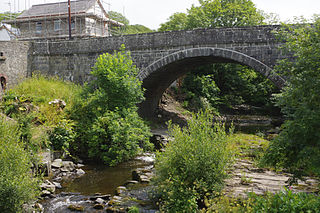
Caerleon Bridge is a bridge crossing of the River Usk at Caerleon in the city of Newport, Wales, carrying the B4236 road from Caerleon-ultra-Pontem into Caerleon itself.

<span class="mw-page-title-main">Afon Lwyd</span> River in south-east Wales

The Afon Lwyd or Afon Llwyd is a 13-mile (21 km) long river in south-east Wales which flows from its source northwest of Blaenavon, through Abersychan, Pontnewynydd, Pontypool, Llanfrechfa and Cwmbran before flowing, at Caerleon, into the River Usk, which subsequently flows into the Bristol Channel to the south of Newport.

Canaston Bridge is the location in Pembrokeshire, southwest Wales where the A40 trunk road crosses the Eastern Cleddau. It is on the edge of the Pembrokeshire Coast National Park, 14 miles (23 km) northeast of Pembroke, and close to Oakwood Theme Park and Blue Lagoon waterpark. It is about half a mile upstream of Blackpool Mill, at the normal tidal limit of the river.

The Usk Valley Walk is a waymarked long distance footpath in south east Wales, from Caerleon to Brecon.

<span class="mw-page-title-main">Newbridge-on-Usk</span> Village in Monmouthshire, Wales

Newbridge-on-Usk is a hamlet in the village and parish of Tredunnock, near Usk, Monmouthshire, south east Wales, in the United Kingdom.

<span class="mw-page-title-main">River Gavenny</span> River in Monmouthshire, Wales

The River Gavenny or sometimes the Gavenny River is a short river in Monmouthshire in south Wales. It rises 1 mile (1.6 km) southwest of the village of Llanvihangel Crucorney from springs near Penyclawdd Court, supplemented by springs in Blaen-Gavenny Wood and tributary streams there and within the Woodland Trust-owned Great Triley Wood. It flows south for about 4 miles (6.4 km) to its confluence with the River Usk towards the eastern end of Castle Meadows at Abergavenny. The town derives its English-language name from the Gavenny's confluence with the River Usk. Of the buildings on the banks of the river, the Gothic Decorated style church of St Teilo at Llantilio Pertholey is especially notable. Parts of the church date from the thirteenth century with multiple additions since. Blaengavenny Farm, the name of which signifies the 'head of the Gavenny', is a sixteenth-century farmhouse near the river's source.

<span class="mw-page-title-main">Pont-y-Cafnau</span> Bridge in Wales

The Pont-y-Cafnau, is a 14.2-metre (47 ft) long iron truss bridge over the River Taff in Merthyr Tydfil, Wales. The bridge was designed by Watkin George and built in 1793 for his employer, the Cyfarthfa Ironworks, to support both a tramway and an aqueduct to carry limestone and water into the works. A Grade II* listed building and Scheduled Ancient Monument, the Pont-y-Cafnau is the world's earliest surviving iron railway bridge.

<span class="mw-page-title-main">Wye Bridge, Monmouth</span> Bridge in Monmouth, Wales

The Wye Bridge in Monmouth is a bridge across the River Wye. The A466 passes over it and immediately meets the A40 at its western end. The bridge is a grade II listed building. The total span of the bridge is 71 metres (233 ft).

<span class="mw-page-title-main">Usk Bridge (Brecon)</span> Bridge in Brecon, mid-Wales

The Usk Bridge in Brecon, Powys, Wales is the town's oldest route over the River Usk. It carries the B4601 road, formerly the A40, between Brecon and Llanfaes.

<span class="mw-page-title-main">Pont Aberarth</span> Grade II listed bridge in Wales

Pont Aberarth, also known as the Llanddewi-Aberarth Bridge, is a single-arched grade II listed bridge, which spans the River Arth in the village of Aberarth, Ceredigion, Wales. It was completed in 1849, and carries the A487 trunk road between Cardigan and Aberystwyth.

<span class="mw-page-title-main">Blackpool Mill</span>

Blackpool Mill is a 19th century flour mill in the community of Martletwy, in the Pembrokeshire Coast National Park. It sits to the west of Blackpool Bridge on the southern bank of the Eastern River Cleddau, downstream from Canaston Bridge. Built in 1813 on the site of former ironworks, the mill is a Grade-II* listed building, which is intact and contains working machinery, but has ceased commercial operation. Blackpool Mill is listed by RCAHMW as an historic place name.

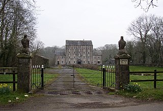
Abercamlais is a Grade I listed country house in the Usk valley between Brecon and Sennybridge in Powys, Wales. Possibly dating back to the Middle Ages, it underwent various alterations and additions during the nineteenth century accounting for all or most of what may be seen today. Also of note is an early eighteenth century octagonal dovecote. The gardens attached to the house extend on both sides of the Usk and are connected by both a grade II* listed Elizabethan three arch stone bridge and a wrought iron suspension bridge constructed by Crawshay Bailey in the middle of the nineteenth century. It is considered a fine piece of Victorian engineering and listed by Cadw accordingly.

<span class="mw-page-title-main">Penpont Manor House</span>

Penpont is a seventeenth-century Grade I listed manor house in the Usk valley between Brecon and Sennybridge in Powys, Wales. It was built by Daniel Williams on the site of, and perhaps incorporating, an earlier house, Abercamlais-isaf. The frontage dates from 1815. Penpont Bridge, a grade II* listed structure, spans the Usk by means of four segmented stone arches. The gardens at Penpont are influenced by Repton but have a long history from the seventeenth century with the addition of a celebrated Green Man maze in recent years. They are listed Grade II* on the Cadw/ICOMOS Register of Parks and Gardens of Special Historic Interest in Wales.

References

  1. "Usk at Chain Bridge". Centre for Ecology and Hydrology.
  2. "Usk Management Catchment Summary" (PDF). Natural Resources Wales. Retrieved 25 April 2020.
  3. Davies, John; Jenkins, Nigel; Baines, Menna; Lynch, Peredur I. (2008). The Welsh Academy Encyclopaedia of Wales (First ed.). Cardiff: University of Wales Press. p. 904. ISBN   9780708319536.
  4. Owen, Hywel Wyn; Morgan, Richard (2007). Dictionary of the Place-names of Wales. Gomer Press. ISBN   978-1-84323-901-7., page 484.
  5. A reproduction of the map is at File:Atlas_Ortelius_KB_PPN369376781-011av-011br.jpg
  6. "River Usk/ Afon Wysg - Special Areas of Conservation". sac.jncc.gov.uk.
  7. Ordnance Survey 1:25,000 scale Explorer map sheet 152 Newport & Pontypool
  8. "The Bridges over the Usk | Abercamlais".
  9. "Cwm-wysg Mill". coflein. RCAHMW. Retrieved 24 July 2020.
  10. "Watergate Corn Mill". coflein. RCAHMW. Retrieved 24 July 2020.
  11. "Millbrook Mill". coflein. RCAHMW. Retrieved 24 July 2020.
  12. "Buckland Old Mill". coflein. RCAHMW. Retrieved 24 July 2020.
  13. "Old corn mill, Aberhoyw". coflein. RCAHMW. Retrieved 24 July 2020.
  14. "Knight's Cornmill". coflein. RCAHMW. Retrieved 24 July 2020.
  15. "Usk Vale Mill, Glangrwyey". coflein. RCAHMW. Retrieved 24 July 2020.
  16. "Forge Mill". coflein. RCAHMW. Retrieved 24 July 2020.
  17. "Gorratts Mill". coflein. RCAHMW. Retrieved 24 July 2020.
  18. "Prioress Mill". coflein. RCAHMW. Retrieved 24 July 2020.
  19. "Upper Usk, leat". coflein. RCAHMW. Retrieved 24 July 2020.
  20. Day, Mildred Leake (1994), "The Rise of Gawain, Nephew of Arthur", in Wilhelm, James J. (ed.), The Romance of Arthur, New York: Garland, p. 366
  21. Camelot in Norris J. Lacy, Editor, The Arthurian Encyclopedia (1986 Peter Bedrick Books, New York) 75-6.