
Yining, also known as Ghulja or Kulja, is a county-level city in Northwestern Xinjiang, China and the seat of Ili Kazakh Autonomous Prefecture. Historically, Yining is the successor to the ruined city of Almaliq in neighbouring Huocheng County. Yining is the third largest city in Xinjiang after Ürümqi and Korla.

Ruili is a county-level city of Dehong Prefecture, in the west of Yunnan province, China. It is a major border crossing between China and Myanmar, with the town of Muse located across the border.

Changji is a county-level city situated about 40 km (25 mi) west of the regional capital, Ürümqi in Northern Xinjiang, China and has about 390,000 inhabitants. It is the seat of Changji Hui Autonomous Prefecture. At the northeast corner of the modern city are the walls and other archaeological remains of the Tang dynasty city, usually referred to as Ancient Changji.

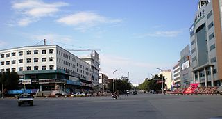
Bole, also known by its Mongolian name Bortala, is a county-level city in Xinjiang, China. It is the seat of Bortala Mongol Autonomous Prefecture, which borders Kazakhstan. The city covers an area of 7,517 square kilometres (2,902 sq mi) and has a total population of 270,000 as of 2015. The Northern Xinjiang Railway runs through the city, as do highways to Ürümqi.
Usu as the official romanized name and transliterated from Mongolian, also known as Wusu, is a county-level city with more than 100,000 residents in Xinjiang, China. It is a part of Tacheng Prefecture of Ili Kazakh Autonomous Prefecture. Oil production is a major part of the economy while the county is an oasis in the Dzungarian Basin. Wusu lies between the major cities of Bole and Shihezi in Northern Xinjiang and west of Ürümqi and Kuitun, south of Karamay.

Tacheng, also known as Tarbagatay, Chuguchak or Qoqek, is a county-level city and the administrative seat of Tacheng Prefecture, in northern Ili Kazakh Autonomous Prefecture, Xinjiang. The Chinese name "Tacheng" is an abbreviation of "Tarbagatay City", a reference to the Tarbagatay Mountains. Tacheng is located in the Dzungarian Basin, some 10 km (6.2 mi) from the Chinese border with Kazakhstan. For a long time it has been a major center for trade with Central Asia because it is an agricultural hub. Its industries include food processing, textiles, and utilities.
Aral is a sub-prefecture-level city surrounded by Aksu Prefecture in Xinjiang Uyghur Autonomous Region, China. Aral means "island" in Uyghur. The city's name is often written as Alar.

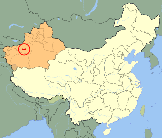
Bortala Mongol Autonomous Prefecture is an autonomous prefecture in the northern Xinjiang, China. Its capital is Bole, also known as Bortala. It has a population of 475,483 inhabiting an area of 27,000 km2 (10,000 sq mi). Despite being designated an autonomous area for Mongols in China, only a little over five and a half per cent of Bortala's population is Mongol.

Wujiaqu is a county-level city in the northern part of Xinjiang Uyghur Autonomous Region, China, about 40 kilometres (25 mi) north of Ürümqi.
Alashankou railway station, also known as Alataw Pass railway station, is a railway station in Börtala Mongol Autonomous Prefecture of China's Xinjiang Uyghur Autonomous Region.

Qitai County as the official romanized name, also transliterated from Uyghur as Guqung County or Gucheng County, is a county in the Xinjiang Uyghur Autonomous Region of China under the administration of the Changji Hui Autonomous Prefecture. It covers an area of 16,641 square kilometres (6,425 sq mi) and as of the 2002 census had a population of 230,000.

Hutubi County as the official romanized name, also transliterated from Uyghur as Kutubi County, is a county in the Xinjiang Uyghur Autonomous Region and is under the administration of the Changji Hui Autonomous Prefecture. It contains an area of 9,476 km2. According to the 2002 census, it has a population of 210,000.
Ürümqi County is a county of Xinjiang Uyghur Autonomous Region, Northwest China, it is under the administration of the prefecture-level city of Ürümqi, the capital of Xinjiang. It contains an area of 4,601 km² and according to the 2002 census has a population of 80,000.
Dostyk or Druzhba is a small town in Kazakhstan's Jetisu Region, on the border with Xinjiang, China. It is a port of entry from China. The rail portion serves as an important link in the Eurasian Land Bridge. It is situated in the Dzungarian Gate, a historically significant mountain pass.

Khorgos, officially known as Korgas, is a county-level city in Ili Kazakh Autonomous Prefecture, Xinjiang, China. It straddles the country's border with Kazakhstan; on the Kazakh side of the border is a city also named Horgos in Russian and Korgas in Kazakh.

The Northern Xinjiang railway or Beijiang railway is a railway in Xinjiang, China, between Ürümqi, the regional capital of Xinjiang, and Alashankou on the border with Kazakhstan. The railway is 460 km (290 mi) in length and runs along the northern slope of the Tian Shan mountain range, connecting all major cities and towns of the southern Junggar Basin, including Changji, Hutubi, Manas, Shihezi, Kuytun, Wusu, Bortala (Bole), Jinghe and Alashankou. The line extends the Lanzhou–Xinjiang railway west from Ürümqi to the Turkestan–Siberia railway on the Kazakh border and forms a section of the Trans-Eurasian Railway from Rotterdam to Lianyungang. The line opened in 1992. It was partially funded by the government loan of the Soviet Union.

The Jingyihuo railway, short for Jinghe–Yining–Khorgas railway, is the first electrified railway in operation in Xinjiang, China. The line is 286 km in length and connects Jinghe, Yining and Khorgos. The Jingyihuo railway branches from the Northern Xinjiang railway at Jinghe in the Junggar Basin and heads south through the Tian Shan range into the Ili River Valley. Cities and towns along route include Jinghe, Nilka County, Yining County, Yining, Huocheng County and Khorgos, on the border with Kazakhstan.
Bole Alashankou Airport is an airport serving the cities of Bole and Alashankou in Bortala Mongol Autonomous Prefecture and Shuanghe in Xinjiang Uygur Autonomous Region, China. It is located 18 kilometers east of Bole, 50 kilometers south of the Alashankou border crossing with Kazakhstan, and 10 kilometers north of Shuanghe. Construction started in July 2009 with an investment of 320 million yuan, and the airport was opened on 10 July 2010.
The G3018 Jinghe–Alashankou Expressway, commonly referred to as the Jing'a Expressway, is an expressway under construction between Jinghe County and Alashankou in Bortala Mongol Autonomous Prefecture, Xinjiang, China. It will serve as a connection between Alashankou, the site of the Alataw Pass, which serves as a major border crossing between China and Kazakhstan, and the G30 Lianyungang–Khorgas Expressway at Jinghe. The expressway will be 68.66 kilometres (42.66 mi) in length. It will connect to the future G3019 Bole–Alashankou Expressway at about the halfway point, near the Bole railway station on the Northern Xinjiang railway. It is expected to open at the end of 2018.
The G3019 Bole–Alashankou Expressway, commonly referred to as the Bo'a Expressway, is an expressway under construction between Jinghe County and Alashankou in the Chinese autonomous region of Xinjiang. It will serve as a connection between Alashankou, which serves as a major border crossing between China and Kazakhstan known as the Alataw Pass, and the county-level city of Bole. The expressway is an auxiliary route of the G30 Lianyungang–Khorgas Expressway.


