The University of Plymouth is a public research university based predominantly in Plymouth, England, where the main campus is located, but the university has campuses and affiliated colleges across South West England. With 18,410 students, it is the 57th largest in the United Kingdom by total number of students.

Edinburgh Waverley railway station is the principal railway station serving Edinburgh, Scotland. It is the second busiest station in Scotland, after Glasgow Central. The station serves as the northern terminus of the East Coast Main Line, 393 miles 13 chains from London King's Cross, although some trains operated by London North Eastern Railway continue to other Scottish destinations beyond Edinburgh.

Suburban Station is an art deco office building and underground commuter rail station in Penn Center in Philadelphia. Its official SEPTA address is 16th Street and JFK Boulevard. The station is owned and operated by SEPTA and is one of the three core Center City stations on the SEPTA Regional Rail and one of the busiest stations in the Regional Rail System.

Durham College Oshawa GO station is a station for commuter rail, passenger rail and regional bus services in Oshawa, Ontario, Canada. It is the terminal station for the Lakeshore East line of GO Transit and serves Via Rail's Corridor service, which travels from Toronto to both Ottawa and Montreal. The bus terminal is served by bus routes of GO Transit and Durham Region Transit.

Plymouth railway station serves the city of Plymouth, Devon, England. It is on the northern edge of the city centre, close to the North Cross roundabout. It is the second busiest station in the county of Devon, and the largest of the six surviving stations in Plymouth.

Budapest Keleti station is the main international and inter-city railway terminal in Budapest, Hungary.

Exeter College is a general further education college in Exeter, Devon; it was first such college in England, and is currently the highest-ranked in the country. The college has its origins in the Royal Albert Memorial Museum, founded in 1869, and first became an independent institution in 1893 as the Exeter Technical and University Extension College. After using various different sites, the college's preceding institution moved into its present main campus in 1959, and was established in its present form as the first English further education college in 1970. The majority of its present buildings were constructed from 2005 onward.

Milford Haven railway station serves the town of Milford Haven in Pembrokeshire, Wales. Opened on 7 September 1863, it was originally known as Milford, becoming Old Milford by January 1902, and finally being renamed Milford Haven by April 1910. It is the westernmost railway station in Wales, but not in Great Britain as some stations in England and Scotland are further west.

Aberdeen railway station is the main railway station in Aberdeen, Scotland. It is the busiest railway station in Scotland north of the major cities of Glasgow and Edinburgh. It is located on Guild Street in the city centre, next to Union Square.

North Pole depot is a railway and maintenance depot built for Great Western Railway's AT300 units from the Hitachi A-train family. Located in the London Borough of Hammersmith and Fulham, the depot was partially redeveloped by Agility Trains from 2013 as a maintenance site when they were awarded the Intercity Express Programme.

Brussels-South railway station, officially Brussels-South, is a major railway station in Brussels, Belgium. Geographically, it is located in Saint-Gilles/Sint-Gillis on the border with the adjacent municipality of Anderlecht and just south of the City of Brussels.
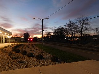
Capital Area Multimodal Gateway, also known as East Lansing station, is an intermodal transit station in East Lansing, Michigan. Operated by the Capital Area Transportation Authority (CATA), it is served by Amtrak's Blue Water passenger train, local buses, and intercity buses. It opened in 2015 to replace a nearby Amtrak and bus station operating since 1974.

Curzon Gate was a residential development located on the edge of Birmingham City Centre, West Midlands, England, on a prominent gateway site into the city centre. The land was formerly occupied by Castle Cement silos. The 4-acre (1.6 ha) site was located in the Eastside area, which is currently witnessing a large-scale regeneration scheme. It was located next to Curzon Park and opposite Eastside Locks, both of which are developments. It was bounded by a railway viaduct to the south and a road junction on the A4540 road. It was separated from Curzon Park by the Digbeth Branch Canal.

The Plymouth Blitz was a series of bombing raids carried out by the Nazi German Luftwaffe on the English city of Plymouth in the Second World War. The bombings launched on numerous British cities were known as the Blitz.

Neuss Central Station is the railway station for the city of Neuss in the German state of North Rhine-Westphalia. The main station building is built on a platform between the tracks and it is located at the junction of the Lower Left Rhine Railway and the Mönchengladbach–Düsseldorf railway. These lines also connect with the Düren–Neuss railway and the Neuss–Viersen railway; the latter has ended since 1984 at Kaarster See station and is operated by the private Regiobahn company.
The Campus of the University of Southern California, also known as the University Park Campus is located in the Exposition Park neighborhood of Los Angeles, California. The campus sprawls across 226 acres and contains most of the academic facilities and residential buildings of the University of Southern California. The University Park campus is in the University Park district of Los Angeles, 2 miles (3.2 km) southwest of downtown Los Angeles. The campus's boundaries are Jefferson Boulevard on the north and northeast, Figueroa Street on the southeast, Exposition Boulevard on the south, and Vermont Avenue on the west. Since the 1960s, through-campus vehicle traffic has been either severely restricted or entirely prohibited on some thoroughfares. The University Park campus is within walking distance to Los Angeles landmarks such as the Shrine Auditorium and Los Angeles Memorial Coliseum, which is operated and managed by the University. Most buildings are in the Romanesque Revival style, although some dormitories, engineering buildings, and physical sciences labs are of various Modernist styles that sharply contrast with the predominantly red-brick campus. Widney Alumni House, built-in 1880, is the oldest university building in Southern California. In recent years the campus has been renovated to remove the vestiges of old roads and replace them with traditional university quads and gardens. The historic portion of the main campus was listed on the National Register of Historic Places in 2015.

Drake is an election ward within Plymouth, Devon, England. One of the main roads from the city to Tavistock and Dartmoor runs through the ward. In the past it played an important role in the supply of water to Plymouth, and it was the location of both a fatal bomb explosion and a large unexploded bomb during the Plymouth Blitz. The University of Plymouth has its main campus in this ward and the large student population has led to part of it being designated as one of the four areas subject to Designated Public Places Orders in the city. It is also the location of the city's main railway station, museum and public library.

The KTM ETS, commercially known as ETS, short for Electric Train Service, is an inter-city rail passenger service in Malaysia operated by Keretapi Tanah Melayu (KTM) using electric multiple-unit (EMU) trains. The KTM ETS is the second electric train service to be operated by the Malaysian railway company, after the KTM Komuter service, and the second inter-city rail service, after KTM Intercity.

The British Rail Class 802 is a type of high-speed bi-mode multiple-unit passenger train designed and produced by the Japanese manufacturer Hitachi Rail. It has been operated by Great Western Railway, TransPennine Express, and Hull Trains; each of these train operating companies has given its own units a unique brand: Great Western Railway's units are branded Intercity Express Trains (IETs), TransPennine Express units are branded Nova 1s and Hull Trains' units are branded Paragons.
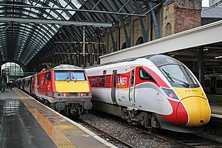
London North Eastern Railway (LNER) is a British train operating company. It is owned by DfT OLR Holdings for the Department for Transport (DfT). The company's name echoes that of the London and North Eastern Railway, one of the Big Four companies which operated between 1923 and 1948.


