The list of postcode areas in the United Kingdom is a tabulation of the postcode areas used by Royal Mail for the purposes of directing mail within the United Kingdom. The postcode area is the largest geographical unit used and forms the initial characters of the alphanumeric UK postcode. [1] There are currently 121 geographic postcode areas in use in the UK and a further three often combined with these covering the Crown Dependencies of Guernsey, Jersey and Isle of Man.
Each postcode area is further divided into post towns and postcode districts. [1] There are on average 20 postcode districts to a postcode area, [1] with ZE having the lowest (3) and BT the highest (81). The London post town is instead divided into several postcode areas. [2]
The single or pair of letters chosen for postcode areas are generally intended as a mnemonic for the places served. [1] Postcode areas, post towns and postcode districts do not follow political or local authority administrative boundaries and usually serve much larger areas than the place names with which they are associated. Many post towns are former "county towns" but postcode areas rarely align with the county (or successor authority) area. For example, within the PA postcode area the PA1 and PA78 postcode districts are 140 miles (225 km) apart, and cover 5 local authority areas; and the eight postcode areas of the London post town cover only 40% of Greater London. [2] The remainder of its area is covered by sections of twelve adjoining postcode areas: EN, IG, RM, DA, BR, TN, CR, SM, KT, TW, HA and UB. [2]
Postcode area | Postcode area name [1] [3] | Code formation | Number of postcode districts within area |
---|---|---|---|
AB | Aberdeen | 33 (Highest number 56) | |
AL | St Albans | 10 | |
B | Birmingham | 79 (Highest number 98) | |
BA | Bath | 19 (Highest number 22) | |
BB | Blackburn | 13 (Highest number 18) | |
BD | Bradford | 27 (Highest number 99) | |
BH | Bournemouth | 26 (Highest number 31) | |
BL | Bolton | 10 (Highest number 9) | |
BN | Brighton | 30 (Highest number 45) | |
BR | Bromley | 8 | |
BS | Bristol | 37 (Highest number 49) | |
BT | Belfast | 81 (Highest number 94) | |
CA | Carlisle | 28 | |
CB | Cambridge | 16 (Highest number 25) | |
CF | Cardiff | 35 (Highest number 83) | |
CH | Chester | 37 (Highest number 66) | |
CM | Chelmsford | 25 (Highest number 77) | |
CO | Colchester | 16 | |
CR | Croydon | 9 (Highest number 8) | |
CT | Canterbury | 21 | |
CV | Coventry | 24 (Highest number 47) | |
CW | Crewe | 12 | |
DA | Dartford | 18 | |
DD | Dundee | 11 | |
DE | Derby | 23 (Highest number 75) | |
DG | Dumfries [1] | Dumfries and Galloway | 15 (Highest number 16) |
DH | Durham | 9 | |
DL | Darlington | 17 | |
DN | Doncaster | 32 (Highest number 41) | |
DT | Dorchester | 11 | |
DY | Dudley | 14 | |
E | East London | 20 (Includes E1W) | |
EC | East Central London | 23 (Layout for EC is different, e.g.: EC2R 8AH, highest number 4/4Y) | |
EH | Edinburgh | 54 (Highest number 55) | |
EN | Enfield | 11 | |
EX | Exeter | 33 (Highest number 39) | |
FK | Falkirk | 21 | |
FY | Blackpool [1] | The Fylde | 8 |
G | Glasgow | 52 (Highest number 84) | |
GL | Gloucester | 27 (Highest number 56) | |
GU | Guildford | 38 (Highest number 52) | |
HA | Harrow | 10 (Highest number 9) | |
HD | Huddersfield | 9 | |
HG | Harrogate | 5 | |
HP | Hemel Hempstead | 24 (Highest number 27) | |
HR | Hereford | 9 | |
HS | Hebrides | 9 | |
HU | Hull | 20 | |
HX | Halifax | 7 | |
IG | Ilford | Possibly Ilford and Gants Hill (or Barking) | 11 |
IP | Ipswich | 33 | |
IV | Inverness | 52 (Highest number 63) | |
KA | Kilmarnock | Possibly Kilmarnock and Ayr or Kilmarnock | 30 |
KT | Kingston upon Thames | 24 | |
KW | Kirkwall | 16 (Highest number 17) | |
KY | Kirkcaldy | 16 | |
L | Liverpool | 40 | |
LA | Lancaster | 23 | |
LD | Llandrindod Wells [1] | 8 | |
LE | Leicester | 21 (Highest number 67) | |
LL | Llandudno | 67 (Highest number 78) | |
LN | Lincoln | 13 | |
LS | Leeds | 29 | |
LU | Luton | 7 | |
M | Manchester | 43 (Highest number 90) | |
ME | Medway | 20 | |
MK | Milton Keynes | 26 (Highest number 46) | |
ML | Motherwell | 12 | |
N | North London | 23 (Includes N1C, Highest number 22) | |
NE | Newcastle upon Tyne [4] [5] | 61 (Highest number 71) | |
NG | Nottingham | 29 (Highest number 34) | |
NN | Northampton | 19 (Highest number 29) | |
NP | Newport | 18 (Highest number 44) | |
NR | Norwich | 35 | |
NW | North West London | 11 | |
OL | Oldham | 16 | |
OX | Oxford | 27 (Highest number 49) | |
PA | Paisley | 67 (Highest number 80) | |
PE | Peterborough | 38 | |
PH | Perth | 43 (Highest number 50) | |
PL | Plymouth | 35 | |
PO | Portsmouth | 34 (Highest number 41) | |
PR | Preston | 11 (Highest number 26) | |
RG | Reading | 30 (Highest number 45) | |
RH | Redhill | 20 | |
RM | Romford | 20 | |
S | Sheffield | 45 (Highest number 81) | |
SA | Swansea | 51 (Highest number 73) | |
SE | South East London | 28 | |
SG | Stevenage | 19 | |
SK | Stockport | 19 (Highest number 23) | |
SL | Slough | 10 (Highest number 9) | |
SM | Sutton [1] | Possibly Sutton and Morden, the two post towns that are within the SM area [6] | 7 |
SN | Swindon | 18 (Highest number 26) | |
SO | Southampton | 23 (Highest number 53) | |
SP | Salisbury | Salisbury Plain | 11 |
SR | Sunderland | 8 | |
SS | Southend-on-Sea | 17 | |
ST | Stoke-on-Trent | 21 | |
SW | South West London | 27 (SW1 is split into SW1A, -E, -H, -P, -V, -W, -X & -Y; Highest number 20) | |
SY | Shrewsbury | 25 | |
TA | Taunton | 24 | |
TD | Galashiels | Tweeddale | 15 |
TF | Telford | 13 | |
TN | Tunbridge Wells [1] | 40 | |
TQ | Torquay | 14 | |
TR | Truro | 27 | |
TS | Teesside | 29 | |
TW | Twickenham | 20 | |
UB | Southall [1] | Uxbridge | 11 |
W | West London | 26 (W1 is split into W1A to W1D, -F to -H, -J, -K, -S to -U and -W, highest number 14) | |
WA | Warrington | 16 | |
WC | West Central London | 14 (WC1 is split into eight, -A, -B, E, -H, N, -R, V, -X; WC2 is split into six, -A, -B, -E, -H, -N, -R; highest number 2R) | |
WD | Watford | 11 (Highest number 25) | |
WF | Wakefield | 17 | |
WN | Wigan | 8 | |
WR | Worcester | 15 | |
WS | Walsall | 15 | |
WV | Wolverhampton | 16 | |
YO | York | 29 (Highest number 47) | |
ZE | Lerwick [1] | Zetland | 3 |
The Crown dependencies (which are not part of the United Kingdom) did not introduce postcodes until later, but use a similar coding scheme. They are separate postal authorities. [1]
Postcode area | Postcode area name |
---|---|
GY | Guernsey |
JE | Jersey |
IM | Isle of Man |
Glasgow, like London, was divided into compass districts: C, W, NW, N, E, SE, S, SW. When postcodes were introduced, these were mapped into the new G postcode: C1 became G1, W1 became G11, N1 became G21, E1 became G31, S1 became G41, SW1 became G51, and so on. As NW and SE had never been subdivided they became G20 and G40 respectively.
Norwich and Croydon were used for a postcode experiment in the late 1960s, which was replaced by the current system. The format was of the form NOR or CRO followed by two numbers and a letter, e.g. NOR 07A. They were later changed to CR0 (digit '0') and NR1.
When Ireland was a part of the United Kingdom of Great Britain and Ireland a postal district system was introduced in 1917 by the UK government. The letter D was assigned to Dublin. Upon the establishment of the Irish Free State and later, the Republic of Ireland, the Irish government retained the designation and today it forms part of the Eircode system, a postcode format slightly different from the UK format and identifying individual addresses. Since Irish independence, D has never been reassigned as a postcode area in the UK.
Some postcode areas do not correspond to geographical areas. They can be - postcode areas with no geographic link (for use by Large Volume Receivers, with delivery options determined between the LVR and Royal Mail) and these can for general mail or specifc functions (e.g. parcel returns); non-geographic postcode districts or sectors contained within geographic postcode areas (for LVRs or PO Boxes); and specifc purpose postcodes.
Postcode area | Purpose |
---|---|
BF | British Forces Post Office |
BX | National Non-geographic ("Box"?) |
GIR | Girobank (no longer operating) |
XM | Christmas letters to Father Christmas ("XMas") |
XX | Parcel Returns to LVRs; COVID-19 samples |
aa91-aa95 | Business Large Volume Receivers in a postcode district (but this number range is not universal applied, and has many exceptions) |
aa96-aa99 | Government Large Volume Receivers in a postcode district (but this number range is not universally applied, and has many exceptions) |
aanP | PO Boxes, in some London postcode districts e.g. EC1P, N1P (but is not consistently applied) |
For those within geographic postcode areas, the first two numbers can be any number though they are generally larger than the numbers allocated to geographic districts. Some fall within the range 91 to 95 for businesses (e.g. S98 for payments to MNBA Ltd) and the range 96 to 99 for Government departments (e.g. NE98 for Department of Work and Pensions, Central Office, Newcastle-upon-Tyne, EH99 1SP for the Scottish Parliament in Edinburgh). However, there are many exceptions to this - e.g. American Express has the postcode area BN88; in Glasgow G58 1SB is allocated to National Savings, formerly National Savings Bank, as a mnemonic (SB, and with 58 looking like SB), though it is located in the G43 postcode district; and in Glasgow G70 is allocated to HMRC which is located in G67.
The BF postcode area was introduced in 2012 to provide optional postcodes for British Forces Post Office addresses, for consistency with the layout of other UK addresses. It uses the national non-geographic post town "BFPO" and, as of 2012, the postcode district "BF1". Each BFPO number is assigned an inward code, which are gouped as: 0 - Germany, 1 - UK, 2 - Rest of Europe, 3 - Rest of World, 4 - Ships and Naval Parties, 5 - Rest of World, Operations and Exercises, 6 - Rest of World, Operations and Exercises. [7]
The non-geographic postcode area BX has been introduced for addresses which do not include a locality; this allows large organisations long-term flexibility as to where they receive their mail. This postcode area is used by Lloyds Banking Group (BX1 1LT), HSBC (BX8 0HB) and parts of HM Revenue and Customs like VAT (BX5 5AT) and Pay As You Earn (BX9 1AS). Lloyds Bank also use BX4. After splitting from Lloyds, TSB Bank uses BX4 7SB, the latter part of which, when written, looks similar to "TSB".
GIR 0AA is a postcode created for Girobank in Bootle. It remained in use by its successors when Girobank was taken over by Alliance & Leicester and subsequently by Santander UK.
XM4 5HQ is a postcode created for Father Christmas.
The non-geographic postcode area XX is used by online retailers for returns by Royal Mail, and for COVID-19 test samples.
Retailer (or other user) | XX Postcodes |
---|---|
Adidas | XX40 4AA |
Amazon | XX10 1DD (Scottish Distribution Centre) [8] XX10 1ZZ (Yorkshire Distribution Centre) XX30 1FF (South West Distribution Centre) XX40 2PP (National Distribution Centre) XX50 1DD (Scottish Distribution Centre) XX50 9SS (Scottish Distribution Centre) XX60 1XX (Princess Royal Distribution Centre) |
ASOS | XX10 1AA |
Boohoo.com | XX10 1BB |
BT Group | XX10 1BT |
John Lewis | XX10 1EE XX40 1EE |
Marks & Spencer | XX10 1SS |
Very | XX20 1DD |
musicMagpie | XX10 1FF XX20 1BF XX20 1FF |
HP / Cycleon Retail Returns | XX40 1EH XX40 2HH (toner cartridge recycling) |
Nike | XX40 2HH |
Zara | XX40 1EJ |
Mango | XX40 1EN |
Monsoon Accessorize | XX40 1EP |
Boden | XX40 1EG |
H&M | XX40 1HN |
Oasis | XX40 1YY |
Shein | XX40 3SS |
Temu | XX40 1ZZ |
Sky | XX40 4UU |
Biocentre (COVID-19 testing) | XX40 4FL |
AstraZeneca (COVID-19 testing) | XX40 8AZ |
Biocentre (COVID-19 testing) Scotland | XX50 5FL |
Certain British Overseas Territories introduced single postal codes for their territory or major sub-sections of it. These are not UK postcodes, even though many are formatted in a similar fashion:
Territory | Postcode |
---|---|
Anguilla | AI-2640 [9] |
Saint Helena, Ascension and Tristan da Cunha: | ASCN 1ZZ STHL 1ZZ TDCU 1ZZ |
British Indian Ocean Territory | BBND 1ZZ |
British Antarctic Territory | BIQQ 1ZZ |
Falkland Islands | FIQQ 1ZZ [11] |
Gibraltar | GX11 1AA |
Pitcairn Islands | PCRN 1ZZ |
South Georgia and the South Sandwich Islands | SIQQ 1ZZ |
Turks and Caicos Islands | TKCA 1ZZ [12] |
Other overseas territories have introduced their own more extensive postcode systems:
Overseas Territory | Further information |
---|---|
Bermuda | Postal codes in Bermuda |
Cayman Islands | Postal codes in the Cayman Islands |
British Virgin Islands | Postal codes in the British Virgin Islands |
Montserrat | Postal codes in Montserrat |
Civilian residential and business addresses in Akrotiri and Dhekelia are served by Cyprus Postal Services and use Cypriot postal codes.
Mail to Overseas Territories is treated as international if posted in the UK.
A postal code is a series of letters or digits or both, sometimes including spaces or punctuation, included in a postal address for the purpose of sorting mail.
Postal codes used in the United Kingdom, British Overseas Territories and Crown dependencies are known as postcodes. They are alphanumeric and were adopted nationally between 11 October 1959 and 1974, having been devised by the General Post Office. A full postcode is known as a "postcode unit" and designates an area with several addresses or a single major delivery point.
The London postal district is the area in England of 241 square miles (620 km2) to which mail addressed to the London post town is delivered. The General Post Office under the control of the Postmaster General directed Sir Rowland Hill to devise the area in 1856 and throughout its history it has been subject to reorganisation and division into increasingly smaller postal units, with the early loss of two compass points and a minor retraction in 1866. It was integrated by the Post Office into the national postcode system of the United Kingdom during the early 1970s and corresponds to the E, EC, N, NW, SE, SW, W and WC postcode areas. The postal district has also been known as the London postal area. The County of London was much smaller, at 117 square miles (300 km2), but Greater London is much larger at 607 square miles (1,570 km2).
The postal counties of the United Kingdom, now known as former postal counties, were postal subdivisions in routine use by the Royal Mail until 1996. The purpose of the postal county – as opposed to any other kind of county – was to aid the sorting of mail by differentiating between like-sounding post towns. Since 1996 this has been done by using the outward code of the postcode instead. For operational reasons the former postal counties, although broadly based on the counties of the United Kingdom, did not match up with their boundaries: in some cases there were significant differences. The boundaries changed over time as post towns were created or amended.
The British Forces Post Office (BFPO) provides a postal service to HM Forces separate from that provided by Royal Mail in the United Kingdom. BFPO addresses are used for the delivery of mail in the UK and around the world. BFPO moved from its original base at Inglis Barracks, Mill Hill to its current base at RAF Northolt in west London in 2007.
The E (Eastern) postcode area, also known as the London E postcode area, is the part of the London post town covering much of east London, England. It borders the N postcode area to the west, both north of the tidal Thames. Since closure of the East London mail centre, its mail is sorted at Romford Mail Centre together with IG and RM postcode areas.
An address is a collection of information, presented in a mostly fixed format, used to give the location of a building, apartment, or other structure or a plot of land, generally using political boundaries and street names as references, along with other identifiers such as house or apartment numbers and organization name. Some addresses also contain special codes, such as a postal code, to make identification easier and aid in the routing of mail.
The IG postcode area, also known as the Ilford postcode area, is a group of eleven postcode districts in England, within six post towns. These cover parts of eastern Greater London and south-west Essex.
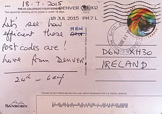
A postal address in Ireland is a place of delivery defined by Irish Standard (IS) EN 14142-1:2011 and serviced by the universal service provider, An Post. Its addressing guides comply with the guidelines of the Universal Postal Union (UPU), the United Nations-affiliated body responsible for promoting standards in the postal industry, across the world.
Military mail, as opposed to civilian mail, refers to the postal services provided by armed forces that allow serving members to send and receive mail. Military mail systems are often subsidized to ensure that military mail does not cost the sender any more than normal domestic mail. In some cases, military personnel in a combat zone may post letters and packages to their home country free of charge. Modern military mail services are provided by most armed forces around the world. In some nations, individual service branches may run their own military mail program.
The KA postcode area, also known as the Kilmarnock postcode area, is a group of 30 postcode districts in south-west Scotland, within 23 post towns. These cover East Ayrshire, North Ayrshire and South Ayrshire.
The BT postcode area, also known as the Belfast postcode area, covers all of Northern Ireland and was the last part of the United Kingdom to be coded, between 1970 and 1974. This area is a group of 82 postcode districts in Northern Ireland, within 44 post towns and around 47,227 live postcodes.
The JE postcode area, also known as the Jersey postcode area, is a group of postal districts covering Jersey.
The SW postcode area, also known as the London SW postcode area, is a group of 20 postcode districts within the London post town in England. The area comprises the South Western operational district and the Battersea operational district, and is the only area within the London post town to lie on both sides of the River Thames.
Postcodes in Australia are used to more efficiently sort and route mail within the Australian postal system. Postcodes in Australia have four digits and are placed at the end of the Australian address, before the country. Postcodes were introduced in Australia in 1967 by the Postmaster-General's Department and are now managed by Australia Post, Australia's national postal service. Postcodes are published in booklets available from post offices or online from the Australia Post website.
In Poland, postal codes were introduced in 1973. They are five-digit codes of two-then-three digits, with a hyphen between them. The first digit indicates one of the 10 large postal regions the country is divided into. These areas do not follow the administrative divisions. The second and third digits specify a particular smaller region, and the last two are the number of a postal delivery branch.