Newport city centre

Last updated

Newport Market Tower (1854) viewed from Upper Dock Street Newport Provisions Market - geograph.org.uk - 522331.jpg
Newport Market Tower (1854) viewed from Upper Dock Street
Newport Arcade looking towards Cambrian Road Newport Arcade - geograph.org.uk - 515556.jpg
Newport Arcade looking towards Cambrian Road
Junction of Commercial Street, Stow Hill and High Street in front of the Westgate Hotel Newport City Centre - geograph.org.uk - 325157.jpg
Junction of Commercial Street, Stow Hill and High Street in front of the Westgate Hotel

Newport city centre is traditionally regarded as the area of Newport, Wales bounded by the west bank of the River Usk, the George Street Bridge, the eastern flank of Stow Hill and the South Wales Main Line. Most of the city centre is contained within two conservation areas: the central area and the area around Lower Dock Street. Most of the city centre is located in the Stow Hill district.

Contents

Description

The main shopping thoroughfare is Commercial Street, which forms part of the north–south axis of High Street, Commercial Street and Commercial Road, linking the heart of the city with Newport Docks. The streets were laid-out in 1807 by Sir Charles Morgan's Tredegar Wharf Company to connect the expanding docks with the main roads in the centre.

The area between Commercial Street and the river used to contain a mixture of railway lines and river wharves so the street pattern in this area was never fixed. On the removal of the railway lines and wharves in the 1960s the large John Frost Square (1977) and Kingsway Shopping Centre were built, close to Newport bus station. This area has been redeveloped to provide the Friars Walk shopping and leisure complex which was opened in November 2015. As part of this redevelopment, the Chartist Mural was destroyed.

Towards the northern end of Newport city centre is Westgate Square, named after the Westgate Hotel. Here, the five roads of Commercial Street, Stow Hill, Bridge Street, High Street and Skinner Street converge. This is generally regarded as the centre although the actual centre, as measured on road signs, is further up Bridge Street outside the Queen's Hotel where most OS maps pin point the centre.

On Upper Dock Street is the Chartist Tower, a 15-storey office block, built in 1966 and the tallest building in Newport. It features a secure underground car park. Radio transmitters and mobile phone masts are situated on the roof. During the 2014 NATO summit a security forces command and control team was housed temporarily in the building, with the top floor and roof being used as an observation post. [1] In 2017 the building was sold as party of a £6.5M deal and has now been developed into a 163-bed Mercure hotel. [2] [3]

From Bridge Street, the two roads of High Street and Cambrian Road run in parallel towards Newport railway station. Joining the two roads is the covered Victorian Newport Arcade. At the western end of the arcade is the Cambrian Centre which is being redeveloped. [4] To the east of High Street is Newport Market, a Grade II-listed building.

Kingsway/Usk Way is a boulevard on the west bank of the River Usk linking Newport Castle the Riverfront Theatre and the University of South Wales to the western ends of City Bridge and Newport Transporter Bridge. The city centre is currently being expanded to include areas on the east bank. The area between Newport Bridge and George Street Bridge is included in the Newport Unlimited master plan as a new high-density combined commercial and residential area, joined to the west bank by Newport City footbridge. The plan shows a strong urban form along the riverfront, emphasised with tall landmark buildings. [5]

The city's major sports stadium, at Rodney Parade on the east bank of the River Usk, is a short walk from the city centre via Newport Bridge or Newport City footbridge.

Business

Admiral House, Queensway, Newport Admiral House, Newport.jpg
Admiral House, Queensway, Newport

Many of the non-retail city centre businesses are located on Bridge Street. In 2014 Admiral Insurance opened a large newly constructed office opposite Newport railway station.

Chartist Tower

The 16 storey Chartist Tower is the tallest building in Newport, and is currently undergoing a £10m redevelopment into a mixed use building by developers, set to include a hotel, 30,000 sq. ft of office space and 18,000 sq. ft of ground floor retail space. [6]

Shopping

Friars Walk Friars Walk Shopping Centre 2018.jpg
Friars Walk

Newport's city centre shops are concentrated along the pedestrianised High Street, Commercial Street and adjoining roads. Friars Walk shopping and leisure complex and, linked by John Frost Square, the adjoining Kingsway Shopping Centre are the main under-cover shopping areas. The city centre has suffered from competition from Cwmbran Centre and out-of-town shopping areas at Newport Retail Park to the east and retail parks around Maesglas to the west. The protracted development of Friars Walk was also cited as a reason for high street stores, such as Marks and Spencer, leaving the city centre during the 2010s. [7]

Friars Walk

Friars Walk is a partially under-cover shopping centre and leisure complex with several levels, and a range of high street shops, eateries, a bowling alley and a soft play area.

Kingsway

Kingsway Shopping Centre is an under-cover shopping centre and a car park with over 1000 spaces. It offers a range of high street and privately owned shops, adjoining Newport Museum, Art Gallery and Central Library. It is close to Newport bus station, and was redeveloped in 2008.

Cambrian Centre

The Cambrian Centre is a small shopping centre in Cambrian Road in Newport city centre. Among other units, it houses one of the city's Wetherspoon's public houses, the John Wallace Linton.

A planning application by Holder Mathias Architects was approved in 2007 by Newport City Council for an £87 million redevelopment and refurbishment to be known as City Spires [8] [9] but it was mothballed in 2008 before construction started. An alternative redevelopment plan was started in 2012. [10] [11] [12] [13] The first phase of development, Admiral House, was opened in 2014.

Related Research Articles

<span class="mw-page-title-main">Westgate Hotel</span> Historic hotel in Newport, Wales

The Westgate Hotel, Commercial Street, Newport, Wales is a hotel building dating from the 19th century. On 4 November 1839 the hotel saw the major scenes of the Newport Rising, when 3,000 Chartists, some of them armed, led by John Frost marched on Newport to attempt to secure the release of five of their number who were being held under arrest at the hotel. In the fighting between about 60 soldiers of the 45th Regiment of Foot and police on one side, and a larger number of Chartists on the other, 10-22 Chartists were killed and more than 50 wounded. The hotel is a Grade II listed building.

<span class="mw-page-title-main">Caerleon</span> Town and community in Newport, Wales

Caerleon is a town and community in Newport, Wales. Situated on the River Usk, it lies 5 miles (8 km) northeast of Newport city centre, and 5.5 miles (9 km) southeast of Cwmbran. Caerleon is of archaeological importance, being the site of a notable Roman legionary fortress, Isca Augusta, and an Iron Age hillfort. Close to the remains of Isca Augusta are the National Roman Legion Museum and the Roman Baths Museum. The town also has strong historical and literary associations: Geoffrey of Monmouth elevated the significance of Caerleon as a major centre of British history in his Historia Regum Britanniae, and Alfred Lord Tennyson wrote Idylls of the King (1859–1885) while staying in Caerleon.

<span class="mw-page-title-main">Newport, Wales</span> City and County Borough in Wales

Newport is a city and county borough in Wales, situated on the River Usk close to its confluence with the Severn Estuary, 12 mi (19 km) northeast of Cardiff. With a population of 145,700 at the 2011 census, Newport is the third-largest authority with city status in Wales, and seventh most populous overall. Newport became a unitary authority in 1996 and forms part of the Cardiff-Newport metropolitan area. Newport was the site of the last large-scale armed insurrection in Great Britain, the Newport Rising of 1839. The population grew considerably during the 2021 census, rising to 159,587, the largest growth of a unitary authority in Wales.

<span class="mw-page-title-main">Cardiff city centre</span> Central Business District in Wales

Cardiff city centre is the city centre and central business district of Cardiff, Wales. The area is tightly bound by the River Taff to the west, the Civic Centre to the north and railway lines and two railway stations – Central and Queen Street – to the south and east respectively. Cardiff became a city in 1905.

Swansea city centre in Swansea, Wales, contains the main shopping, leisure and nightlife district in Swansea. The city centre covers much of the Castle ward including the area around Oxford Street, Castle Square, and the Quadrant Shopping Centre; Alexandra Road, High Street, Wind Street and the Castle; Parc Tawe; and the Maritime Quarter extending down to the seafront.

<span class="mw-page-title-main">Newport Unlimited</span>

Newport Unlimited was a Welsh Urban Regeneration Company created in 2003 to help counter the impacts of decline in Newport's heavy industry and manufacturing. It was initially given a 10-year lifespan.

<span class="mw-page-title-main">Kingsway Shopping Centre</span> Shopping mall in Newport, Wales

The Kingsway Shopping Centre is an under-cover shopping centre in Newport city centre, Wales. The northern pedestrian entrance is on John Frost Square adjoining the Friars Walk shopping and leisure complex. The east pedestrian entrance is off Commercial Street. The west pedestrian entrance is on Emlyn Street. The centre is a short walk from the high street shops of Commercial Street and High Street. Newport railway station is also a short walk away.

<span class="mw-page-title-main">Newport Museum</span> Museum in Newport, Wales

Newport Museum and Art Gallery is a museum, library and art gallery in the city of Newport, South Wales. It is located in Newport city centre on John Frost Square and is adjoined to the Kingsway Shopping Centre.

<span class="mw-page-title-main">Friars Walk, Newport</span> Shopping mall in Newport, South Wales

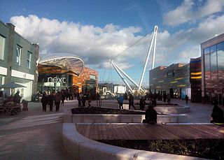
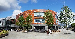
Friars Walk is a partially under-cover shopping centre and leisure complex in Newport city centre, South Wales. It has several levels and includes a range of high street shops, eateries, a cinema, a bowling alley and a soft play area. The complex is linked by the redeveloped John Frost Square to the Kingsway Shopping Centre, Newport Museum, Art Gallery and Central Library and Newport bus station. The complex is a short walk from the high street shops of Commercial Street and High Street. Newport railway station is also a short walk away.

<span class="mw-page-title-main">Newport bus station</span> Bus terminus and interchange in Newport, Wales

Newport Central bus station is a bus terminus and interchange located in the city centre, Newport, South Wales. It is the largest road transport hub for public services in the county. It is situated on the Newport Market site and the adjacent Friars Walk site.

<span class="mw-page-title-main">Newport Market</span> Victorian market in Newport, Wales

Newport Market is a traditional Victorian indoor market, in Newport, South Wales. It is an early example of a large-span cast iron-frame building featuring a glass-filled barrel roof.

<span class="mw-page-title-main">Kingsway, Glen Waverley</span> Street in Melbourne, Australia

Kingsway is a shopping, dining and entertainment precinct at the town centre of Glen Waverley, a southeastern suburb of Melbourne, Victoria, Australia. It starts off at the northern end from High Street, and runs north-south parallel to Springvale Road before curving east at its southern end to join the latter as a T-intersection.

<i>Chartist Mural</i> Mosaic in Newport, Wales

The Chartist Mural was a mosaic mural designed by Kenneth Budd and created in 1978 in a pedestrian underpass in Newport, Wales. It commemorated the Newport Rising of 1839, in which an estimated 22 demonstrators were killed by troops. It was 115 feet (35 m) long and 13 feet (4.0 m) high. The mural was demolished in 2013 amid considerable controversy and misinformation. The original decision to remove the artwork was taken in 2005 by the Labour Controlled Council to allow Modus development company to build the Friars Walk shopping centre. Modus were removed by the Conservative/Lib Dem coalition Council after taking control in 2008 and replaced with Queensbury Development Company Friars Walk.

<span class="mw-page-title-main">John Frost Square</span>

John Frost Square is a large public space in the centre of Newport, South Wales, named after the Chartist leader, John Frost. It was redeveloped as part of the Friars Walk shopping and leisure complex in 2014 and 2015.

<span class="mw-page-title-main">Commercial Street, Newport</span>

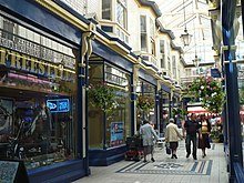
Commercial Street is a 700-yard (660-metre) long main shopping street leading from the city centre of Newport, South Wales.

<span class="mw-page-title-main">High Street, Newport, Wales</span> Historic main street of Newport, South Wales

High Street is the main historical street and the original main thoroughfare in the centre of Newport, South Wales. Nowadays it runs approximately 280m between Westgate Square and the Old Green Interchange.

<span class="mw-page-title-main">National Cycle Route 88</span> Cycle route in the United Kingdom

National Cycle Route 88 is a route of the National Cycle Network, running from Newport to its planned finish site at Margam.

<span class="mw-page-title-main">Chartist Tower</span> High-rise building in Newport, Wales

Chartist Tower is a 53.3 metre tall high rise building in west Newport, Wales. It was built in 1966, and is the tallest building in the city.

References

  1. Barry, Sion (21 December 2017). "The tallest building in Newport acquired in a multi-million pound deal" . Retrieved 2 April 2018.
  2. Farell-Roig, Estel (27 January 2018). "First artist impressions released for Newport's Chartist Tower". The Argus. Retrieved 8 November 2018.
  3. Griffiths, Niall (4 July 2018). "Council approve 163-bed hotel plans for Newport's Chartist Tower". South Wales Argus. Retrieved 8 November 2018.
  4. "Cambrian Centre redevelopment". Southwalesargus.co.uk. 18 April 2012. Retrieved 10 August 2014.
  5. "Development Brief - Rodney Parade, Newport Planning and Design Guidelines" (PDF). www.newport.gov.uk. Archived from the original (PDF) on 30 June 2007.
  6. "Ambitious plans to transform Newport high-rise into hotel set for green light". South Wales Argus. Retrieved 19 February 2019.
  7. Morris, Steven (20 May 2013). "Newport fails to curb retail exodus as big names pack up shop". The Guardian. London. Retrieved 1 December 2014.
  8. "City Spires given the go-ahead". Building Design : 2. 31 August 2007.
  9. "Wales' newest city rides on the crest of a wave". Western Mail . 3 January 2007. p. 22.
  10. Hamilton, Helen (12 November 2011). "...the party's over". Estates Gazette : 80–81.
  11. "Cambrian Centre redevelopment". Southwalesargus.co.uk. 18 April 2012. Retrieved 22 January 2013.
  12. Crockett, Natalie (30 January 2012). "New plans for Newport's Cambrian Centre". Lancashire Telegraph . Retrieved 17 August 2014.
  13. Barry, Sion (31 January 2013). "Admiral signs up for Cambrian Centre office space". Western Mail. p. 25. Retrieved 17 August 2014.