Ahu Akivi

Last updated
Ahu Akivi
Easter Island, Ahu Akivi (6747686253).jpg
At Ahu Akivi, the moai face the ocean. Although the platform is clearly visible, the overgrown grass obscures the pattern of the sloping pavement.
Ahu Akivi
27°6′54″S109°23′42″W / 27.11500°S 109.39500°W / -27.11500; -109.39500
LocationEaster Island
Designer Rapanui people
TypeSacred stone statues
MaterialVolcanic rock
Length70m
Height16 ft
Beginning dateOriginally 15th century
Completion dateRestored in 1960
Dedicated to Make Make worship
Map of Rapa Nui Island Easter Island map-en.svg
Map of Rapa Nui Island
William Mulloy and a moai being restored at Ahu Akivi Mulloy 1955.jpg
William Mulloy and a moai being restored at Ahu Akivi

Ahu Akivi is a particular sacred place on the Chilean island of Rapa Nui (or Easter Island), looking out towards the Pacific Ocean. The site has seven moai, all of equal shape and size, and is also known as a celestial observatory that was set up around the 16th century. The site is located inland, rather than along the coast. Moai statues were considered by the early people of Rapa Nui as their ancestors or Tupuna that were believed to be the reincarnation of important kings or leaders of their clans. The Moais were erected to protect and bring prosperity to their clan and village. [1]

Contents

A particular feature of the seven identical moai statues is that they exactly face sunset during the Spring Equinox and have their backs to the sunrise during the Autumn Equinox. Such an astronomically precise feature is seen only at this location on the island. [1]

Geography

Ahu Akivi, aligned in an east–west direction, [2] is located on the flank of the southern slope of Maunga Terevaka at Rapauni and it is surrounded by fairly flat agricultural land. It is 2.3 kilometres (1.4 mi) inland in the non coastal zone and is at an elevation of 140 metres (460 ft). Ahu Vai Teka is at a distance of 706.8 metres (2,319 ft) from Ahu Kavi which is considered as part of the Ahu Akivi-Ahu Kavi complex. [3]

From Hanga Roa, an inland road leads to the site via the volcanic cone of Terevaka (510 metres (1,670 ft) peak level). The coast road is via Playa Anakena. On this road there are many moai statues lying scattered and un restored. There are paths branching off to Puna Pau, which is a quarry of low volcanic crater with red coloured rocks known as scoria, which has been used to carve 70 of the "top hat" of the statues known as pukao which could be cylindrical top knot of hair or grass hat or turban. Further on, the site of Ahu Akivi is reached. [4] The site is located to the Northeast of Hanga Roa, [5] the capital city of Easter Island, about 10 kilometres (6.2 mi) to its north. [2]

The Rano Raraku quarry from where the statues were made is at least 15 kilometres (9.3 mi) away and free access is through the land route held by the clans. [3]

History

Ahu Akivi is part of the Ahu Akivi-Vai Teka complex which was built up by the Rapa Nui people in two phases. In the first phase, during the 16th century a central rectangular platform was created on a leveled surface. It had wings projecting to the north and the south directions. An approach ramp was also part of this platform which led to the ceremonial plaza stretching 25 metres (82 ft) towards the west of the central platform. A cremation ground existed behind the central platform. The second phase of construction was elaborately planned and implemented in the early years of the 17th century when the platform was modified, a ramp was created, seven statues of equal size were erected. Another crematorium was also built. A cave in which people used to reside was also used as tomb during historic times. [3]

The other Ahu in the complex is the Ahu Vai Teka, which is a much smaller platform of 16 metres (52 ft) length made up of rough lava stone blocks. There is no statue now, though one is believed to have existed initially. Both the ahus were believed to have been aligned astronomically with respect to the Sun. Both are located in the territory of the Miru, the highest ranking clan and the western confederacy, and both were contemporary. It is also conjectured that the seven statues were placed at Ahu Akivi at least 150 years before the first Europeans found the island when the clan was functional at that time. It is also evident that their culture existed for 250–300 years with economic prosperity with political stability. [3]

In 1955, Thor Heyerdahl recruited American archaeologist William Mulloy and his Chilean associate, Gonzalo Figueroa García-Huidobro, who later restored the statues to their original position; they had found them in knocked down condition in 1960. [1] Mulloy's work on the Akivi-Vaiteka Complex was supported by the Fulbright Foundation and by grants from the University of Wyoming, the University of Chile and the International Fund for Monuments. Ahu Akivi also gives its name to one of the seven regions of Rapa Nui National Park. [1]

Legend

The statues on the island invariably faced the village as a protective mana, but in the case of the Ahu Akivi statues they face towards the sea. There is a legend narrated for this positioning of the seven statues. It is conjectured that the Rapanui people did it to propitiate the sea to help the navigators. However, according to an oral tradition, Hotu Matu's priest had a dream in which the King's soul flew across the ocean when the Rapa Nui island was seen by him. He then sent scouts navigating across the sea to locate the island and to find people to settle there. Seven of these scouts stayed back on the island waiting for the king to arrive. These seven are represented by the seven stone statues erected in their honour. [6] [2]

Features

Closer view of Ahu Akivi statues Easterstatues.jpg
Closer view of Ahu Akivi statues

The architectural features of an Ahu platform were discerned by archaeologists, depending on its length under five categories. These are: A central platform of varying length; platform made of crude masonry in its rear wall or with fine masonry in the rear wall; with or without wings; with one or more statues; a red scoria top knot (headgear), ramp, a crematoriums plaza pavement, crafted front retaining wall, a cornice made of red scoria. In the case of the Ahu Akivi all these features have been noted except that the rear part of the platform is made of crude masonry wall. [6] Another feature of the foundation of the platform is that the stones used to make it are not from the island but were brought as ballast in the 19th century in a ship. [2]

Apart from the above, archeologists also unearthed stone disks, small statues, and fish hooks made of stones and bones indicative of burial ceremonies that were performed at the site. [6]

The seven moai statues are located with absolute astronomical precision. Thus, the sacred observatory and sanctuary with all the seven moai look exactly towards the point where the sun sets during the equinox and which also aligns with the Moon. Each one is of 16 feet (4.9 m) height and weighs about 18 tons, [7] and its length is 70 metres (230 ft). [2]

During the excavations done here, the archaeologists also found tree root moulds, indicative of vegetative cover in the past. [5]

Restoration

In 1960, when the American archaeologist and his associate carried out restoration, it took them one month to rise and fix the first moai in place. They used a stone ramp and two wooden levers to carry out this operation. However, they took less than a week to raise the seventh one. [8]

See also

Related Research Articles

<span class="mw-page-title-main">Easter Island</span> Chilean island in the Pacific

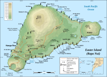
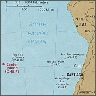
Easter Island is an island and special territory of Chile in the southeastern Pacific Ocean, at the southeasternmost point of the Polynesian Triangle in Oceania. The island is most famous for its nearly 1,000 extant monumental statues, called moai, which were created by the early Rapa Nui people. In 1995, UNESCO named Easter Island a World Heritage Site, with much of the island protected within Rapa Nui National Park.

<span class="mw-page-title-main">Hanga Roa</span> Main town of Easter Island, Chile

Hanga Roa is the main town, harbour and seat of Easter Island, a municipality of Chile. It is located in the southern part of the island's west coast, in the lowlands between the extinct volcanoes of Terevaka and Rano Kau.

<span class="mw-page-title-main">Moai</span> Monolithic human figures on Easter Island

Moai or moʻai are monolithic human figures carved by the Rapa Nui people on Rapa Nui in eastern Polynesia between the years 1250 and 1500. Nearly half are still at Rano Raraku, the main moai quarry, but hundreds were transported from there and set on stone platforms called ahu around the island's perimeter. Almost all moai have overly large heads, which account for three-eighths of the size of the whole statue. They also have no legs. The moai are chiefly the living faces of deified ancestors.

<span class="mw-page-title-main">Rapa Nui people</span> Polynesian inhabitants of Easter Island

The Rapa Nui are the indigenous Polynesian peoples of Easter Island. The easternmost Polynesian culture, the descendants of the original people of Easter Island make up about 60% of the current Easter Island population and have a significant portion of their population residing in mainland Chile. They speak both the traditional Rapa Nui language and the primary language of Chile, Spanish. At the 2017 census there were 7,750 island inhabitants—almost all living in the village of Hanga Roa on the sheltered west coast.

<span class="mw-page-title-main">Rano Raraku</span> Volcanic crater in Easter Island

Rano Raraku is a volcanic crater formed of consolidated volcanic ash, or tuff, and located on the lower slopes of Terevaka in the Rapa Nui National Park on Easter Island in Chile. It was a quarry for about 500 years until the early eighteenth century, and supplied the stone from which about 95% of the island's known monolithic sculptures (moai) were carved. Rano Raraku is a visual record of moai design vocabulary and technological innovation, where 887 moai remain. Rano Raraku is in the World Heritage Site of Rapa Nui National Park and gives its name to one of the seven sections of the park.

<span class="mw-page-title-main">Pukao</span> Topknots on Easter Island statues

Pukao are the hat-like structures or topknots formerly placed on top of some moai statues on Easter Island. They were all carved from a very light-red volcanic scoria, which was quarried from a single source at Puna Pau.

<i>Aku-Aku</i> Book by Thor Heyerdahl

Aku-Aku: the Secret of Easter Island is a 1957 book by Thor Heyerdahl published in Norwegian, Swedish, Danish and Finnish, and in French and English the following year. The book describes the 1955–1956 Norwegian Archaeological Expedition's investigations of Polynesian history and culture at Easter Island, the Austral Islands of Rapa Iti and Raivavae, and the Marquesas Islands of Nuku Hiva and Hiva Oa. Visits to Pitcairn Island, Mangareva and Tahiti are described as well.

<span class="mw-page-title-main">Rapa Nui National Park</span> World Heritage Site in Easter Island

Rapa Nui National Park is a national park and UNESCO World Heritage Site located on Easter Island, Chile. Rapa Nui is the Polynesian name of Easter Island; its Spanish name is Isla de Pascua. The island is located in the southeastern Pacific Ocean, at the southeastern extremity of the Polynesian Triangle. The island was taken over by Chile in 1888. Its fame and World Heritage status arise from the 887 extant stone statues known by the name "moai", whose creation is attributed to the early Rapa Nui people who inhabited the island starting between 300 and 1200 AD. Much of the island has been declared as Rapa Nui National Park which, on 22 March 1996, UNESCO designated a World Heritage Site under cultural criteria (i), (iii), & (v). Rapa Nui National Park is now under the administrative control of the Ma´u Henua Polynesian Indigenous Community, which is the first autonomous institute on the island. The indigenous Rapa Nui people have regained authority over their ancestral lands and are in charge of the management, preservation and protection of their patrimony. On the first of December 2017, the ex-President Michelle Bachelet returned ancestral lands in the form of the Rapa Nui National Park to the indigenous people. For the first time in history, the revenue generated by the National Park is invested in the island and used to conserve the natural heritage.

<span class="mw-page-title-main">Anakena</span> Beach on Easter Island

Anakena is a white coral sand beach in Rapa Nui National Park on Rapa Nui, a Chilean island in the Pacific Ocean. Anakena has two ahus; Ahu-Ature has a single moai and Ahu Nao-Nao has seven, two of which have deteriorated. It also has a palm grove and a car park.

<span class="mw-page-title-main">Ahu Tongariki</span> Stone platform on Easter Island

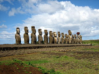
Ahu Tongariki is the largest ahu on Easter Island. Its moais were toppled during the island's civil wars, and in the twentieth century the ahu was swept inland by a tsunami. It has since been restored and has fifteen moai, including one that weighs eighty-six tonnes, the heaviest ever erected on the island. Ahu Tongariki is one kilometer from Rano Raraku and Poike in the Hotu-iti area of Rapa Nui National Park. All the moai here face sunset during the winter solstice.

<span class="mw-page-title-main">Rano Kau</span> Dormant volcano in Easter Island

Rano Kau is a 324 m (1,063 ft) tall dormant volcano that forms the southwestern headland of Easter Island, a Chilean island in the Pacific Ocean. It was formed of basaltic lava flows in the Pleistocene with its youngest rocks dated at between 150,000 and 210,000 years ago.

<span class="mw-page-title-main">Terevaka</span> Extinct volcano in Easter Island

Ma'unga Terevaka is the largest, tallest and youngest of three main extinct volcanoes that form Easter Island. Several smaller volcanic cones and craters dot its slopes, including a crater hosting one of the island's three lakes, Rano Aroi.

<span class="mw-page-title-main">Puna Pau</span> Prehistoric quarry in Easter Island

Maunga Puna Pau is a small crater or cinder cone and prehistoric quarry on the outskirts of Hanga Roa in the south west of Easter Island. Puna Pau gives its name to one of the seven regions of the Rapa Nui National Park.

Since the removal from Easter Island in 1868 of the moai now displayed at the British Museum, a total of 12 moai are known to have been removed from Easter Island and to remain overseas. Some of the moai have been further transferred between museums and private collections, for reasons such as the moai's preservation, academic research and for public education. In 2006, one relocated moai was repatriated from the Centro Cultural Recoleta in Argentina after 80 years overseas. In 2022, one moai held in the Chilean National Museum of Natural History in Santiago was returned to the island after 150 years abroad.

<span class="mw-page-title-main">History of Easter Island</span>

Geologically one of the youngest inhabited territories on Earth, Easter Island, located in the mid-Pacific Ocean, was, for most of its history, one of the most isolated. Its inhabitants, the Rapa Nui, have endured famines, epidemics of disease, civil war, environmental collapse, slave raids, various colonial contacts, and have seen their population crash on more than one occasion. The ensuing cultural legacy has brought the island notoriety out of proportion to the number of its inhabitants.

<span class="mw-page-title-main">Sebastian Englert</span>

Father Sebastian Englert OFM Cap., was a Capuchin Franciscan friar, Roman Catholic priest, missionary, linguist and ethnologist from Germany. He is known for his pioneering work on Easter Island, where the Father Sebastian Englert Anthropological Museum is named after him.

<span class="mw-page-title-main">William Mulloy</span>

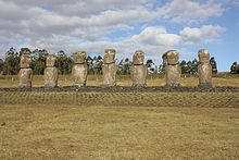
William Thomas Mulloy Jr. was an American anthropologist. While his early research established him as a formidable scholar and skillful fieldwork supervisor in the province of North American Plains archaeology, he is best known for his studies of Polynesian prehistory, especially his investigations into the production, transportation and erection of the monumental statuary on Rapa Nui known as moai.

<span class="mw-page-title-main">Tahai</span> Archaeological site on Easter Island

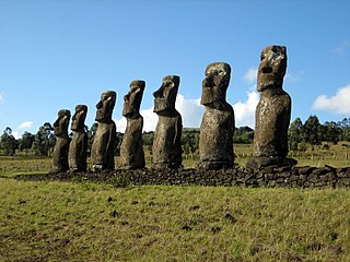
The Tahai Ceremonial Complex is an archaeological site on Rapa Nui in Chilean Polynesia. Restored in 1974 by American archaeologist William Mulloy, Tahai comprises three principal ahu from north to south: Ko Te Riku, Tahai, and Vai Ure. Visible in the distance from Tahai are two restored ahu at Hanga Kio'e, projects that Mulloy undertook in 1972. Like other Mulloy restoration projects at Ahu Akivi, the ceremonial village of Orongo and Vinapu, the ceremonial center at Tahai now constitutes an integral part of the Rapa Nui National Park, designated by UNESCO as a World Heritage site.

<span class="mw-page-title-main">Ahu Vinapu</span>

Ahu Vinapu is an archaeological site on Rapa Nui in Eastern Polynesia.

Gonzalo Figueroa Garcia Huidobro, often referred to simply as Gonzalo Figueroa, was an archaeologist and authority on the conservation of the archaeological heritage of Rapa Nui. Figueroa's work included participating in Thor Heyerdahl's Rapa Nui expedition, restoring Ahu Akivimoai with William Mulloy, and working generally for over four decades to conserve and, in some cases, restore the archaeological monuments of Rapa Nui for future generations.

References

  1. 1 2 3 4 "Easter Island: stones, history. Easter Island". Lost Civilizations.net. Retrieved 13 August 2013.
  2. 1 2 3 4 5 "Ahu Akivi – The Seven scouts from Easter Island" (in German). Osterinsel.de. Archived from the original on 20 June 2015. Retrieved 13 August 2013.
  3. 1 2 3 4 Peregrine & Ember 2001, p. 51.
  4. Graham 2003, p. 537.
  5. 1 2 Flenley & Bahn 2003, p. 250.
  6. 1 2 3 Kirch 1986, p. 73.
  7. Maras 2010, p. 25.
  8. "Ahu Akivi". NOVA Online and Public Broadcasting Service (PBS) Organization. Retrieved 13 August 2013.

Bibliography

Further reading