Antiphellus

Last updated

Antiphellus
Antifellos
Ancient Greek: Ἀντίφελλος
Antiphellus Ancient Theatre - 2014.10 - panoramio.jpg
The ancient Greek theatre overlooking the sea
Antiphellus
Location Kaş, Antalya Province, Turkey
Region Lycia
TypeSettlement
Site notes
Archaeologists Charles Fellows
ConditionRuined, now mostly built on by the modern town

Antiphellus or Antiphellos (Turkish : Antifellos, Ancient Greek : Ἀντίφελλος), known originally as Habesos, was an ancient coastal city in Lycia. The earliest occurrence of its Greek name is on a 4th-century-BCE inscription. Initially settled by the Lycians, the city was occupied by the Persians during the 6th century BCE. It rose in importance under the Greeks, when it served as the port of the nearby inland city of Phellus, but once Phellus started to decline in importance, Antiphellus became the region's largest city, with the ability to mint its own coins. During the Roman period, Antiphellus received funds from the civic benefactor Opramoas of Rhodiapolis that may have been used to help rebuild the city following the earthquake that devastated the region in 141.

Contents

The Irish naval officer Sir Francis Beaufort discovered the site of the city in the 1820s, when it was deserted. During a visit in April 1840, the English archaeologist and explorer Charles Fellows noted the existence of over 100 stone tombs. Much of the city's archaeological remains has since been destroyed due to the growth of Kaş (formerly Andifili) during the modern period; most of the sarcophagi being destroyed when the local population used the flat-sided stones for building materials.

Surviving inscriptions written in the now extinct Lycian language date from the 4th century BCE. The restored Hellenistic amphitheatre at Antiphellus, originally built to seat 4000 spectators, and still largely complete, never possessed a permanent stone stage. Surviving ruins visible on the ground include the 4th century BCE Doric Tomb, which has a 1.9 metres (6 ft 3 in) high entrance and a chamber decorated with a relief of dancing girls; the King's Tomb, located in the centre of the modern town, which has a uniquely written and as yet untranslated Lycian inscription; a small 1st century BCE temple; rock tombs set in cliffs above the modern town; and parts of the city's ancient sea wall.

History

The original Lycian name for Antiphellus (Ancient Greek: "the land opposite the rocks") was Habesos; [1] [2] according to the Roman military commander Pliny the Elder, the city's pre-Hellenic name was Habessus. [2] The discovery of architectural elements, now in the Antalya Museum, have confirmed that the Lycians had settled there (and therefore also Phellus) by the 6th century BCE. [3] It was entitled to one vote at the Lycian_League, and emerged to be a centre of trade that minted its own coins. [1] The area was invaded by the Persians in around the middle of the 6th century BCE. [1]

Map showing the location of Phellus and Antiphellus Phellus and Antiphellus map.svg
Map showing the location of Phellus and Antiphellus

Located at the head of a bay on the region's southern coast, the settlement served during the Hellenic period as the port of the nearby inland city of Phellus, [4] although despite the vulnerability of its coastal position, neither a defensive wall or an acropolis was ever built there. [5] The earliest mention of the Greek name Antiphellus is on an inscription on a 4th-century-BCE tomb in Kaş, which describes the deceased man as originating from Antiphellus. [6] As Phellus declined in importance, Antiphellus emerged to become the region's largest city. [4]

The city, unlike Phellus, is mentioned in the Roman guidebook for sailors, the Stadiasmus Maris Magni . [7] Roman imperial coins found at Antiphellus bear the legend Ἀντιφελλειτων [4] ("of the Antiphellitans"). [8] Pliny wrote that the softest sponges were found in the area. [5] The Roman scholar Strabo incorrectly placed Antiphellus among the inland cities: [9] [10]

And in the interior are places called Phellus and Antiphellus and Chimaera, which last I have mentioned above.

According to the Turkish archaeologist Cevdet Bayburtluoğlu, Antiphellus was probably affected by the earthquake that devastated the region in 141–142. [11] The shock from this earthquake triggered a tsunami that inundated the Lycian coast and travelled a considerable distance inland. [12] Funds known to have been donated to the city by Opramoas of Rhodiapolis may have been used to help repair the damage caused by this event. [11]

The bishopric of Antiphellus was a suffragan of the metropolitan see of Myra, the capital of the Roman province of Lycia. Its bishop Theodorus took part in the Council of Chalcedon in 451. He also attended the provincial synod held in 458 in connection with the murder of Proterius of Alexandria, but because of health difficulties with his hands, the acts of the meeting were signed on his behalf by the priest Eustathius. [13] [14] No longer a residential bishopric, Antiphellus is today listed by the Catholic Church as a titular see. [15]

The site is now in the municipality of Kaş, Turkey, which before the forcible population exchange between Greece and Turkey of 19221923 was called Andifili, [4] and during the 19th century, Andiffelo. [16]

Archaeology

Antiphellus, all but deserted by 1828, [17] and built up in the following decades, became known during the mid-19th century, both to scholars and travellers. [16] The Irish naval officer Sir Francis Beaufort visited Antiphellus in the 19th century. He gave a description of what he found there, including the amphitheatre and groups of inscribed and plain sarcophagi, noting that the inscriptions he saw were: "from the rudeness of their execution, to be very antient. Intermixed with the usual Greek letters, there are several uncommon characters of which the following are a few specimens." [18]

George Schaff 's illustration of tombs at Antiphellus (c. 1843) George Schaff - Tombs at Antiphellus.jpg
George Schaff 's illustration of tombs at Antiphellus (c.1843)

The English archaeologist and explorer Charles Fellows saw the ruins of Antiphellus in April 1838. [19] During a return visit in April 1840, Fellows noted the existence of over 100 tombs. [20] In 1841, he produced drawings of specimens of ends of sarcophagi, pediments, and doors of tombs, and Thomas Abel Brimage Spratt's Travels in Lycia, Milyas, and the Cibyratis (1847) contains a plan of the ancient city's ruins. [9] Fellows and his companions found a tomb with a bilingual inscription (a cast was made in 1844); and he sketched the pillar tomb that now stands in the centre of the modern town. [21]

The abandoned Lycian settlement left hillside tombs, including a sarcophagus on a high base with a long inscription in "Lycian B", [4] now generally identified as Milyan, a Luwian language. Inscriptions in the Lycian language are dated from the 4th century BCE, as are the earliest records in Greek inscriptions. One such inscription, copied by Fellows in 1840, contains the ethnic name ΑΝΤΙΦΕΛΛΕΙΤΟΥ. [22] Much of the archaeology at Antiphellus has been lost due to the urban development of Kaş; [23] Fellows observed that the settlement had expanded even since his previous visit and had swallowed up many of the ruins. [24] Excavations carried out in the modern town in 1952 produced few results, leading the archaeological team to conclude that 4th century Antiphellus consisted of a few buildings, concentrated near the harbour. [8]

Description of existing ruins

Amphitheatre

Ellinistic theatre.jpg
The amphitheatre at Kaş
Amphitheatre at Kas (Antiphellus) - details of restoration.jpg
Details of the 2008 restoration

The Hellenistic amphitheatre, which was restored in 2008, [25] is located 500 metres (1,600 ft) from the centre of Kaş. It was capable of seating 4000 spectators. [26] The amphitheatre is the only structure of its type in Anatolia with a sea front. [27] It is complete, but lacks a proscenium, so as to avoid blocking the view of the sea. [11] [9]

After the amphitheatre was built, the east wall collapsed, possibly due to the earthquake that devastated the region in 141. Repairs to the wall are visible; the restoration work was done soon afterwards, probably by means of the funds provided to Antiphellus by Opramoas. [11]

The retaining wall of the amphitheatre, which curves around in slightly more than a semicircle, is built of irregular ashlar blocks, which vary in size and shape. There is no diazoma (the passage dividing the lower from the upper rows of seats), nor a permanent stone stage. [28]

King's Tomb

Inscription on the King's Tomb, Kas, Turkey.png
The inscription on the King's Tomb (the images overlap slightly). The characters are well preserved and still readable, although sometimes it is impossible to decide whether depressions on the surface are part of the text or not. [29]

One of the town's sarcophagi is the 4th century BCE Lycian Inscribed Mausoleum, known locally as the King's Tomb, which is located on Uzunçarşı Street. [27] It is in excellent condition. [30] The hyposorium, which is cut from the solid rock, is approximately 5 feet (1.5 m) in height; the floor is sunken and the entrance is unsealed. The base is 30 inches (760 mm) high. [30] On the hyposorium is an unusual type of Lycian epitaph, being in the form of a poem, as observed by Fellows in the 1840s, who wrote that "the inscription does not begin in the manner of any of those we have yet met with, nor does it contain any words of a funereal character". [31] The text is written in the Milyan language (otherwise known as Lycian B), an extinct ancient Anatolian language attested from only three inscriptions: two poems on the Xanthian Obelisk, and the shorter inscription on the King's Tomb. [32] The text has not been interpreted. [30] The free space under the inscription suggests the text was supposed to be longer, and that the stonemason, intending to save space, accidentally left too much room. [33]

The sarcophagus on top is cut from a separate block of stone. Two lions' heads project from the sides of the lid, which is divided into four panels showing standing figures in relief. [30] The sarcophagus was kept for the tomb's builder and his wife, who are depicted in the front pediment as a bearded man leaning on a staff in front of a seated woman. [34]

Luigi Mayer - Colossal Sarcophagus near Castle Rosso (1803) Mayer - Colossal Sarcophagus near Castle Rosso (1803).jpg
Luigi MayerColossal Sarcophagus near Castle Rosso (1803)

The tomb was first depicted, but not discussed, in Luigi Mayer's Views in the Ottoman Empire, published in London in 1803. [35] A copy of the inscription, made by the British archaeologist William Gell in 1812, was one of the first copies of any Lycian inscription. Between 1836 and 1842 the inscription was copied by the French historian Charles Texier, Charles Fellows, the classical philologist Julius August Schönborn, and the English artist Edward Thomas Daniell. It was copied again in 1882, 1892, and 1894, before the Austrian classical philologist Ernst Kalinka published the authoritative copy of the inscription in 1901. [36]

Other remains

Most of the ancient tombs found by Fellows have since disappeared, [20] as the local population used most of them for building materials. [37] The isolated tomb above the amphitheatre, known as the Doric Tomb, is of a unique form. [28] Cube shaped and cut into the rock face, with sides of 4.5 metres (15 ft). The east-facing entrance is 1.9 metres (6 ft 3 in) high and leads to a single chamber. [38] One of the inside walls has a relief of dancing girls, now grimy due to the tomb's use as a shepherds' shelter. From the clothes worn by the dancers, scholars have dated the tomb to the first half of the 4th century BCE. [39] The base has a moulding and a shallow pilaster at each corner; only one of the capitals has survived. On the south side a band with mutules is preserved. The entrance, which was originally closed by means of a sliding door, has a moulded frame. [28]

Temple wall, Kas (Antiphellus).jpg
Part of the temple wall
Antiphellos - rock tomb.jpg
A rock tomb
Antiphellos - Doric tomb.jpg
The Doric Tomb

The lower parts of a small temple have survived. The remains have a height of five blocks of rectangular ashlar. It was constructed in the 1st century BCE, with later additions added four centuries later. The temple was dedicated to an unknown god. [40] [11]

There are rock tombs in the cliffs just beyond the modern town, including one with both a Lycian inscription and a later one written in Latin. [41] Remnants of a wall on the shoreline are still visible. [42] The harbour lay on the seaward side of the isthmus, where a reef runs out to sea, providing protection; it may have been strengthened in ancient times. Antiphellus had neither an acropolis nor a city wall. The part of the ashlar sea-wall that survives to the west of the modern town stands six courses high for a length of over 500 yards (460 m). [5]

Related Research Articles

<span class="mw-page-title-main">Lycia</span> Ancient geopolitical region of Anatolia (Turkey)

Lycia was a state or nationality that flourished in Anatolia from 15–14th centuries BC to 546 BC. It bordered the Mediterranean Sea in what is today the provinces of Antalya and Muğla in Turkey as well some inland parts of Burdur Province. The state was known to history from the Late Bronze Age records of ancient Egypt and the Hittite Empire. Lycia was populated by speakers of the Luwian language group. Written records began to be inscribed in stone in the Lycian language after Lycia's involuntary incorporation into the Achaemenid Empire in the Iron Age. At that time (546 BC) the Luwian speakers were displaced as Lycia received an influx of Persian speakers. Ancient sources seem to indicate that an older name of the region was Alope.

<span class="mw-page-title-main">Myra</span> Ancient Greek town in Lycia

Myra was a Lycian, then ancient Greek, then Greco-Roman, then Byzantine Greek, then Ottoman town in Lycia, which became the small Turkish town of Kale, renamed Demre in 2005, in the present-day Antalya Province of Turkey. In 1923, its Greek inhabitants had been required to leave by the population exchange between Greece and Turkey, at which time its church was finally abandoned. It was founded on the river Myros, in the fertile alluvial plain between Alaca Dağ, the Massikytos range and the Aegean Sea.

<span class="mw-page-title-main">Xanthos</span> Ancient Lycian city in southwest Turkey

Xanthos or Xanthus, also referred to by scholars as Arna, its Lycian name, was an ancient city near the present-day village of Kınık, in Antalya Province, Turkey. The ruins are located on a hill on the left bank of the River Xanthos. The number and quality of the surviving tombs at Xanthos are a notable feature of the site, which, together with nearby Letoon, was declared to be a UNESCO World Heritage Site in 1988.

<span class="mw-page-title-main">Lycian Way</span> Long-distance trail

The Lycian Way is a marked long-distance hiking trail in southwestern Turkey around part of the coast of ancient Lycia. It is approximately 520 km (320 mi) in length and stretches from Hisarönü (Ovacık), near Fethiye, to Aşağı Karaman in Konyaaltı, about 20 km (12 mi) from Antalya. It is waymarked with red and white stripes of the GR footpath convention.

<span class="mw-page-title-main">Letoon</span> Lycian sanctuary settlement on the Mediterranean coast of Turkey

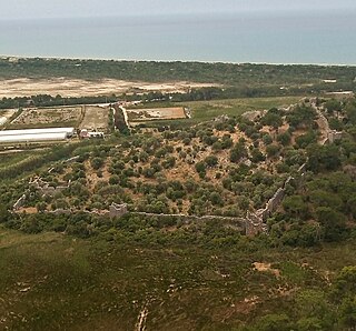
Letoon or Letoum in the Fethiye district of Muğla Province, Turkey, was a sanctuary of Leto located 4 kilometres (2.5 mi) south of the ancient city of Xanthos, to which it was closely associated, and along the Xanthos River. It was one of the most important religious centres in the region though never a fully-occupied settlement.

<span class="mw-page-title-main">Pinara</span> Large ancient city of Lycia

Pinara was a large city of ancient Lycia at the foot of Mount Cragus, and not far from the western bank of the River Xanthos, homonymous with the ancient city of Xanthos.

<span class="mw-page-title-main">Kaş</span> Municipality in Antalya, Turkey

Kaş is a small fishing, diving, yachting and tourist town, and a municipality and district of Antalya Province, Turkey. Its area is 1,750 km2, and its population is 62,866 (2022). It is 168 km west of the city of Antalya. As a tourist resort, it is relatively unspoiled.

Sidyma, was a town of ancient Lycia, at what is now the small village of Dudurga Asari in Muğla Province, Turkey. It lies on the southern slope of Mount Cragus, to the north-west of the mouth of the Xanthus.

<span class="mw-page-title-main">Rhodiapolis</span> City in ancient Lycia

Rhodiapolis, also known as Rhodia (Ῥοδία) and Rhodiopolis (Ῥοδιόπολις), was a city in ancient Lycia. Today it is located on a hill northwest of the modern town Kumluca in Antalya Province, Turkey.

<span class="mw-page-title-main">Phellus</span> Town of ancient Lycia

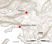
Phellus is the site of an ancient Lycian city, situated in a mountainous area near Çukurbağ in Antalya Province,Turkey. The city was mentioned by the Greek geographer and philosopher Strabo in his Geographica. Antiphellusserved as the city's port.

<span class="mw-page-title-main">Nereid Monument</span> Tomb originally in Xanthos, present-day Turkey; now in the British Museum

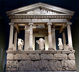
The Nereid Monument is a sculptured tomb from Xanthos in Lycia, close to present-day Fethiye in Mugla Province, Turkey. It took the form of a Greek temple on top of a base decorated with sculpted friezes, and is thought to have been built in the early fourth century BC as a tomb for Arbinas, the Xanthian dynast who ruled western Lycia under the Achaemenid Empire.

<span class="mw-page-title-main">Tomb of Payava</span> Lycian sarcophagus in the British Museum

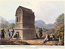
The Tomb of Payava is a Lycian tall rectangular free-standing barrel-vaulted stone sarcophagus, and one of the most famous tombs of Xanthos. It was built in the Achaemenid Persian Empire, for Payava, who was probably the ruler of Xanthos, Lycia at the time, in around 360 BC. The tomb was discovered in 1838 and brought to England in 1844 by the explorer Sir Charles Fellows. He described it as a 'Gothic-formed Horse Tomb'. According to Melanie Michailidis, though bearing a "Greek appearance", the Tomb of Payava, the Harpy Tomb and the Nereid Monument were built according to the main Zoroastrian criteria "by being composed of thick stone, raised on plinths off the ground, and having single windowless chambers".

<span class="mw-page-title-main">Trebenna</span> Archaeological site in Antalya Province, Turkey

Trebenna (Τρεβέννα) or Trabenna (Τραβέννα) was a city in ancient Lycia, at the border with Pamphylia, and at times ascribed to that latter region. Its ruins are located east of the modern town Çağlarca in the Konyaaltı district of Antalya Province, Turkey. The site lies 22 km to the west of Antalya.

<span class="mw-page-title-main">Idebessos</span> Ancient city in Lycia

Idebessos or Idebessus, also known as Edebessus or Edebessos or, was an ancient city in Lycia. It was located at the foot of the Bey Mountains to the west of the Alakır river valley. Today its ruins are found a short distance to the west of the small village of Kozağacı in the Kumluca district of Antalya Province, Turkey. The site, 21 kilometres north-northwest of Kumluca, is overgrown with forest and hard to reach.

<span class="mw-page-title-main">Apollonia (Lycia)</span> City in ancient Lycia

Apollonia was a city in ancient Lycia. Its ruins are located near Kiliçli (Sıçak), a small village in the Kaş district of Antalya Province, Turkey.

<span class="mw-page-title-main">Cyaneae</span> Human settlement

Cyaneae, also spelled Kyaneai or Cyanae, was a town of ancient Lycia, or perhaps three towns known collectively by the name. Leake observes that in some copies of Pliny it is written Cyane; in Hierocles and the Notitiae Episcopatuum it is Cyaneae.

<span class="mw-page-title-main">Nisa (Lycia)</span> Ancient city of Lycia

Nisa, also Nyssa (Νύσσα) or Nysa (Νύσα) or Neisa (Νείσα), was a town in ancient Lycia near the source of the River Xanthus.

<span class="mw-page-title-main">Tombs at Xanthos</span> Tomb complex in Turkey

Xanthos, also called Xanthus, was a chief city state of the Lycians, an indigenous people of southwestern Anatolia. Many of the tombs at Xanthos are pillar tombs, formed of a stone burial chamber on top of a large stone pillar. The body would be placed in the top of the stone structure, elevating it above the landscape. The tombs are for men who ruled in a Lycian dynasty from the mid-6th century to the mid-4th century BCE and help to show the continuity of their power in the region. Not only do the tombs serve as a form of monumentalization to preserve the memory of the rulers, but they also reveal the adoption of Greek style of decoration.

<span class="mw-page-title-main">Isinda (Lycia)</span> Ancient Lycian town

Isinda was a town of ancient Lycia. Isinda was part of a sympoliteia with Aperlae, Apollonia and Simena.

<span class="mw-page-title-main">Pydnae</span> Ancient fortress on the Mediterranean coast of Turkey

References

  1. 1 2 3 Bayburtluoğlu 2004, p. 242.
  2. 1 2 Bean 1978, p. 92.
  3. Keen 2018, p. 28.
  4. 1 2 3 4 5 Bryce 2009, p. 47.
  5. 1 2 3 Bean 1978, p. 94.
  6. Bean, George Ewart. "Antiphellos (Kaş, formerly Andifli) Lycia, Turkey". The Princeton Encyclopedia of Classical Sites. Tufts University . Retrieved 7 June 2023.
  7. Spratt 1847, p. 267.
  8. 1 2 Bean 1978, pp. 92–93.
  9. 1 2 3 Smith 1870, p. 147.
  10. "Strabo, Geography: 3". Perseus Digital Library . Tufts University . Retrieved 6 June 2023.
  11. 1 2 3 4 5 Bayburtluoğlu 2004, p. 243.
  12. Harris & Fachard 2021, pp. 193–194.
  13. Le Quien 1740, coll. 985–986.
  14. Pius Bonifacius Gams 1931, p. 450.
  15. Segreteria di Stato Vaticano 2013, p. 833.
  16. 1 2 Murray 1878, pp. 356–357.
  17. "Letters from the Levant". The New Monthly Magazine and Universal Register. Vol. 23, no. 2. London: Henry Colburn. 1828. pp. 316–319.
  18. Beaufort 1818, pp. 14–16.
  19. Slatter 1994, p. 37.
  20. 1 2 Slatter 1994, p. 151.
  21. Slatter 1994, p. 153.
  22. Long 1857, p. 186.
  23. Varinlioglu 2016, p. 38.
  24. Slatter 1994, p. 290.
  25. "Antiphellos Antik Kenti" [The ancient city of Antiphellos]. Kaş Gezi Rehberi (in Turkish). Retrieved 6 June 2023.
  26. "Antiphellos Theatre". Lonely Planet . Retrieved 12 May 2023.
  27. 1 2 T.C. Antalya Valiliği 2010, p. 335.
  28. 1 2 3 Bean 1978, p. 95.
  29. Schürr 2005, p. 100.
  30. 1 2 3 4 Bean 1978, pp. 95–96.
  31. Kalinka 1901, pp. 53–55.
  32. Schürr 2005, pp. 95–96.
  33. Schürr 2005, p. 99.
  34. Schürr 2005, p. 95.
  35. Schürr 2005, p. 96.
  36. Schürr 2005, pp. 96–97.
  37. Akşit 2006, p. 97.
  38. Akşit 2006, p. 96.
  39. Bayburtluoğlu 2004, p. 244.
  40. Akşit 2006, pp. 94–96.
  41. Akşit 2006, pp. 96–97.
  42. Akşit 2006, p. 94.

Sources

Further reading

36°12′07″N29°38′17″E / 36.20200°N 29.63800°E / 36.20200; 29.63800