Archaeological excavation

Last updated

Excavations at the site of Gran Dolina, in the Atapuerca Mountains, Spain, 2008 Dolina-Pano-3.jpg
Excavations at the site of Gran Dolina, in the Atapuerca Mountains, Spain, 2008
Excavations at Faras, Sudan, 1960s Excavations at Faras 049.jpg
Excavations at Faras, Sudan, 1960s
Excavations at the cave of Santa Ana (Caceres, Extremadura, Spain) SantaAnaCave.JPG
Excavations at the cave of Santa Ana (Cáceres, Extremadura, Spain)

In archaeology, excavation is the exposure, processing and recording of archaeological remains. [1] An excavation site or "dig" is the area being studied. These locations range from one to several areas at a time during a project and can be conducted over a few weeks to several years.

Contents

Excavation involves the recovery of several types of data from a site. This data includes artifacts (portable objects made or modified by humans), features (non-portable modifications to the site itself such as post molds, burials, and hearths), ecofacts (evidence of human activity through organic remains such as animal bones, pollen, or charcoal), and archaeological context (relationships among the other types of data). [2] [3] [4] [5]

Before excavating, the presence or absence of archaeological remains can often be suggested by, non-intrusive remote sensing, such as ground-penetrating radar. [6] Basic information about the development of the site may be drawn from this work, but to understand finer details of a site, excavation via augering can be used.

During excavation, archaeologists often use stratigraphic excavation to remove phases of the site one layer at a time. This keeps the timeline of the material remains consistent with one another. [7] This is done usually though mechanical means where artifacts can be spot dated and the soil processed through methods such as mechanical sieving or water flotation. Afterwards, digital methods are then used record the excavation process and its results. Ideally, data from the excavation should suffice to reconstruct the site completely in three-dimensional space.

History

The first instance of archaeological excavation took place in the sixth century BC when Nabonidus, the king of Babylon, excavated a temple floor that was thousands of years old. [8] During early Roman periods, Julius Caesar's men looted bronze artifacts, and by the medieval period, Europeans had begun digging up pots that had partially emerged from erosion, and weapons that had turned up on farmlands. [8] Antiquarians excavated burial mounds in North America and North-West Europe, which sometimes involved destroying artifacts and their context, losing information about subjects from the past. Meticulous and methodical archaeological excavation took over from antiquarian barrow-digging around the early to mid-nineteenth century and is still being perfected today. [9] [8]

The most dramatic change that occurred over time is the amount of recording and care taken to ensure preservation of artifacts and features.[ citation needed ] In the past, archaeological excavation involved random digging to unearth artifacts. Exact locations of artifacts were not recorded, and measurements were not taken. Modern archaeological excavation has evolved to include removal of thin layers of sediment sequentially and recording of measurements about artifacts' locations in a site.[ citation needed ]

Motivation

There are two basic types of modern archaeological excavation:

  1. Research excavation – when time and resources are available to excavate the site fully and at a leisurely pace. These are now almost exclusively the preserve of academics or private societies who can muster enough volunteer labour and funds. The size of the excavation can also be decided by the director as it goes on.
  2. Development-led excavation – undertaken by professional archaeologists when the site is threatened by building development. [10] This is normally funded by the developer, meaning that time pressure is present, as well as its being focused only on areas to be affected by building. [10] The workforce involved is generally more skilled, however, and pre-development excavations also provide a comprehensive record of the areas investigated. Rescue archaeology is sometimes thought of as a separate type of excavation but in practice tends to be a similar form of development-led practice. Various new forms of excavation terminology have appeared in recent years such as Strip map and sample some of which have been criticized within the profession as jargon created to cover up for falling standards of practice.

Development-led archaeology

There are two main types of trial excavation in professional archaeology both commonly associated with development-led excavation: the test pit or trench and the watching brief. The purpose of trial excavations is to determine the extent and characteristics of archaeological potential in a given area before extensive excavation work is undertaken. This is usually conducted in development-led excavations as part of Project management planning. The main difference between Trial trenching and watching briefs is that trial trenches are actively dug for the purpose of revealing archaeological potential [11] whereas watching briefs are cursory examination of trenches where the primary function of the trench is something other than archaeology, for example a trench cut for a gas pipe in a road. In the US, a method of evaluation called a Shovel test pit is used which is a specified half meter square line of trial trenches dug by hand.

Concepts

Site formation

Archaeological material tends to accumulate in events. A gardener swept a pile of soil into a corner, laid a gravel path or planted a bush in a hole. A builder built a wall and back-filled the trench. Years later, someone built a pigsty onto it and drained the pigsty into the nettle patch. Later still, the original wall blew over and so on. Each event, which may have taken a short or long time to accomplish, leaves a context. This layer cake of events is often referred to as the archaeological sequence or record. It is by analysis of this sequence or record that excavation is intended to permit interpretation, which should lead to discussion and understanding.

The prominent processual archaeologist Lewis Binford highlighted the fact that the archaeological evidence left at a site may not be entirely indicative of the historical events that actually took place there. Using an ethnoarchaeological comparison, he looked at how hunters amongst the Nunamiut Iñupiat of north central Alaska spent a great deal of time in a certain area simply waiting for prey to arrive there, and that during this period, they undertook other tasks to pass the time, such as the carving of various objects, including a wooden mould for a mask, a horn spoon and an ivory needle, as well as repairing a skin pouch and a pair of caribou skin socks. Binford notes that all of these activities would have left evidence in the archaeological record, but that none of them would provide evidence for the primary reason that the hunters were in the area; to wait for prey. As he remarked, waiting for animals to hunt "represented 24% of the total man-hours of activity recorded; yet there is no recognisable archaeological consequences of this behaviour. No tools left on the site were used, and there were no immediate material "byproducts" of the "primary" activity. All of the other activities conducted at the site were essentially boredom reducers." [12]

Stratification

Stratigraphy in the excavation area in the Kerameikos Cemetery (Athens). 1555 - Keramikos archaeological area, Athens - Stratigraphy - Photo by Giovanni Dall'Orto, Nov 12 2009.jpg
Stratigraphy in the excavation area in the Kerameikos Cemetery (Athens).
Stratification at an excavation site in Augsburg, Germany Archaologie schichtengrabung.jpg
Stratification at an excavation site in Augsburg, Germany

In archaeology, especially in excavating, stratigraphy involves the study of how deposits occurs layer by layer. [7] It is largely based on the Law of Superposition. The Law of Superposition indicates that layers of sediment further down will contain older artifacts than layers above. [13] When archaeological finds are below the surface of the ground (as is most commonly the case), the identification of the context of each find is vital to enable the archaeologist to draw conclusions about the site and the nature and date of its occupation. It is the archaeologist's role to attempt to discover what contexts exist and how they came to be created. [14] Archaeological stratification or sequence is the dynamic superimposition of single units of stratigraphy or contexts. [15] The context (physical location) of a discovery can be of major significance. Archaeological context refers to where an artifact or feature was found as well as what the artifact or feature was located near. [16] Context is important for determining how long ago the artifact or feature was in use as well as what its function may have been. [16] The cutting of a pit or ditch in the past is a context, whilst the material filling it will be another. Multiple fills seen in section would mean multiple contexts. Structural features, natural deposits and inhumations are also contexts.

By separating a site into these basic, discrete units, archaeologists are able to create a chronology for activity on a site and describe and interpret it. Stratigraphic relationships are the relationships created between contexts in time representing the chronological order they were created. An example would be a ditch and the back-fill of said ditch. The relationship of "the fill" context to the ditch "cut" context is "the fill" occurred later in the sequence, i.e., you have to dig a ditch first before you can back-fill it. [17] A relationship that is later in the sequence is sometimes referred to as "higher" in the sequence and a relationship that is earlier "lower" though the term higher or lower does not itself imply a context needs to be physically higher or lower. It is more useful to think of this higher or lower term as it relates to the contexts position in a Harris matrix, which is a two-dimensional representation of a site's formation in space and time.

Understanding a site in modern archaeology is a process of grouping single contexts together in ever larger groups by virtue of their relationships. The terminology of these larger clusters varies depending on practitioner, but the terms interface, sub-group, group and land use are common. An example of a sub-group could be the three contexts that make up a burial: the grave cut, the body and the back-filled earth on top of the body. In turn sub-groups can be clustered together with other sub-groups by virtue of their stratigraphic relationship to form groups which in turn form "phases". A sub-group burial could cluster with other sub-group burials to form a cemetery or burial group which in turn could be clustered with a building such as church to produce a "phase." A less rigorously defined combination of one or more contexts is sometimes called a feature.

Phasing

Horse burial in Roman ditch on a development funded site in London. Note "out of phase" pipe intrusion left in for practical reasons Roman horse.png
Horse burial in Roman ditch on a development funded site in London. Note "out of phase" pipe intrusion left in for practical reasons
Excavation in phase has reduced this site to the occupation level of a Romano-Celtic temple (56 Gresham Street, London) Romano celtic temple004.png
Excavation in phase has reduced this site to the occupation level of a Romano-Celtic temple (56 Gresham Street, London)

Phase is the most easily understood grouping for the layman as it implies a near contemporaneous Archaeological horizon representing "what you would see if you went back to a specific point in time". Often but not always a phase implies the identification of an occupation surface "old ground level" that existed at some earlier time. The production of phase interpretations is one of the first goals of stratigraphic interpretation and excavation. Digging "in phase" is not quite the same as phasing a site. Phasing a site represents reducing the site either in excavation or post-excavation to contemporaneous horizons whereas "digging in phase" is the process of stratigraphic removal of archaeological remains so as not to remove contexts that are earlier in time "lower in the sequence" before other contexts that have a latter physical stratigraphic relationship to them as defined by the law of superposition. The process of interpretation in practice will have a bearing on excavation strategies on site so "phasing" a site is actively pursued during excavation where at all possible and is considered good practice.

An "intrusion" or "intrusive object" is something that arrived later to the phase in the strata, for example modern pipework or the 16th-century bottles left by treasure-hunters at Sutton Hoo.

Methods

Kilwinning Abbey Dig

Excavation initially involves the removal of any topsoil. A strategy for sampling the contexts and features is formulated which may involve total excavation of each feature or only portions.

Stratigraphic excavation

In stratigraphic excavation, the goal is to remove some or, preferably, all archaeological deposits and features in the reverse order they were created and construct a Harris matrix as a chronological record or "sequence" of the site. [14] This Harris matrix is used for interpretation and combining contexts into ever larger units of understanding. This stratigraphic removal of the site is crucial for understanding the chronology of events on site.

Stratigraphic excavation involves a process of cleaning or "troweling back" the surface of the site and isolating contexts and edges which are definable as either:

  1. Discrete, discernible "edges" that are formed by being completely separated from the surrounding surface and therefore stratigraphically later than its surroundings
  2. Discrete, discernible "edges" (as in 1.) and have boundaries dictated by the limit of excavation [18]

Following this preliminary process of defining the context, it is then recorded and removed. Often, owing to practical considerations or error, the process of defining the edges of contexts is not followed and contexts are removed out of sequence and un-stratigraphically. This is called "digging out of phase". It is not good practice. After removing a context or if practical a set of contexts such as the case would be for features, the "isolate and dig" procedure is repeated until no man made remains are left on site and the site is reduced to natural.

Tools and techniques

Mechanical excavation

Excavation at the site of the Battle at the Harzhorn (Germany) Harzhorn Grabungsschnitt von unten 1.jpg
Excavation at the site of the Battle at the Harzhorn (Germany)

This describes the use in excavations of various types and sizes of machines from small backhoes to heavy duty earth-moving machinery. Machines are often used in what is called salvage or rescue archaeology in developer-led excavation when there are financial or time pressures. [19] Using a mechanical excavator is the quickest method to remove soil and debris and to prepare the surface for excavation by hand, taking care to avoid damaging archaeological deposits by accident or to make it difficult to identify later precisely where finds were located. [20] The use of such machinery is often routine (as it is for instance with the British archaeological television series Time Team ) [21] but can also be controversial as it can result in less discrimination in how the archaeological sequence on a site is recorded. One of the earliest uses of earth-moving machinery was at Durrington Walls in 1967. An old road through the henge was to be straightened and improved and was going to cause considerable damage to the archaeology. Rosemary Hill describes how Geoffrey Wainwright "oversaw large, high-speed excavations, taking bulldozers to the site in a manner that shocked some of his colleagues but yielded valuable if tantalising information about what Durrington had looked like and how it might have been used." [22] Machines are used primarily to remove modern overburden and for the control of spoil. In British archaeology mechanical diggers are sometimes nicknamed "big yellow trowels".

Recording

Archaeological excavation is an unrepeatable process, since the same area of the ground cannot be excavated twice. [23] Thus, archaeology is often known as a destructive science, where you must destroy the original evidence in order to make observations. To mitigate this, highly accurate and precise digital methods can be used to record the excavation process and its results. [24]

Single context recording system

Single context recording was developed in the 1970s by the museum of London (as well as earlier in Winchester and York) and has become the de facto recording system in many parts of the world and is especially suited to the complexities of deep urban archaeology and the process of Stratification. Each excavated context is given a unique "context number" and is recorded by type on a context sheet and perhaps being drawn on a plan and/or a section. Depending on time constraints and importance contexts may also be photographed, but in this case a grouping of contexts and their associations are the purpose of the photography. Finds from each context are bagged and labeled with their context number and site code for later cross-reference work carried out post-excavation. The height above sea level of pertinent points on a context, such as the top and bottom of a wall are taken and added to plans sections and context sheets. Heights are recorded with a dumpy level or total station by relation to the site temporary benchmark (abbr. T.B.M). Samples of deposits from contexts are sometimes also taken, for later environmental analysis or for scientific dating.

Digital recording

Digital tools used by field archaeologists during excavation include GPS, tablet computers, relational databases, digital cameras, 3d laser scanners, and unmanned aerial vehicles. After high quality digital data have been recorded, these data can then be shared over the internet for open access and use by the public and archaeological researchers. Digital imaging or digital image acquisition is digital photography, such as of a physical scene or of the interior structure of an object. The term is often used to include the processing, compression, storage, printing, and display of the images.

Finds processing

Finds and artifacts that survive in the archaeological record are retrieved in the main by hand and observation as the context they survive in is excavated. Several other techniques are available depending on suitability and time constraints. Sieving (screening) and flotation are used to maximize the recovery of small items such as small shards of pottery or flint flakes, or bones and seeds.

Flotation

Flotation is a process of retrieval that works by passing spoil onto the surface of water and separating finds that float from the spoil which sinks. This is especially suited to the recovery of environmental data stored in organic material such as seeds and small bones. [25] Not all finds retrieval is done during excavation and some, especially flotation, may take place post-excavation from samples taken during excavation.

Sieving

Sieving during an excavation in Sweden.

The use of sieving (screening) is more common on research-based excavations where more time is available. Some success has been achieved with the use of cement mixers and bulk sieving. This method allows the quick removal of context by shovel and mattock yet allows for a high retrieval rate. Spoil is shoveled into cement mixers and water added to form a slurry which is then poured through a large screen mesh. The speed of this technique is offset by the damage it does to more fragile artifacts.

Spot Dating

One important role of finds retrieval during excavation is the role of specialists to provide spot dating information on the contexts being removed from the archaeological record. This can provide advance warning of potential discoveries to come by virtue of residual finds redeposited in contexts higher in the sequence (which should be coming offsite earlier than contexts from early eras and phases). Spot dating also forms part of a confirmation process, of assessing the validity of the working hypothesis on the phasing of site during excavation. For example, the presence of an anomalous medieval pottery sherd in what was thought to be an Iron Age ditch feature could radically alter onsite thinking on the correct strategy for digging a site and save a lot of information being lost due to incorrect assumptions about the nature of the deposits which will be destroyed by the excavation process and in turn, limit the site's potential for revealing information for post-excavation specialists. Or anomalous information could show up errors in excavation such as "undercutting". Dating methodology in part relies on accurate excavation and in this sense the two activities become interdependent.

See also

Related Research Articles

<span class="mw-page-title-main">Artifact (archaeology)</span> Something made by humans and of archaeological interest

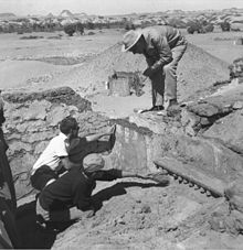
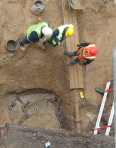
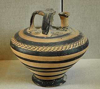
An artifact or artefact is a general term for an item made or given shape by humans, such as a tool or a work of art, especially an object of archaeological interest. In archaeology, the word has become a term of particular nuance and is defined as an object recovered by archaeological endeavor, which may be a cultural artifact having cultural interest.

<span class="mw-page-title-main">Feature (archaeology)</span> Term defining human-built architecture

In archaeological excavation, a feature is a collection of one or more contexts representing some human non-portable activity, such as a hearth or wall. Features serve as an indication that the area in which they are found has been interfered with in the past, usually by humans.

<span class="mw-page-title-main">Section (archaeology)</span>

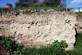
In archaeology a section is a view in part of the archaeological sequence showing it in the vertical plane, as a cross section, and thereby illustrating its profile and stratigraphy. This may make it easier to view and interpret as it developed over time.

<span class="mw-page-title-main">Urban archaeology</span> Archaeological sub-discipline

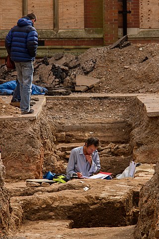
Urban archaeology is a sub discipline of archaeology specializing in the material past of towns and cities where long-term human habitation has often left a rich record of the past. In modern times, when someone talks about living in a city, they are in an area with many surrounding people and buildings, generally quite tall ones. In archaeological terms, cities give great information because of the infrastructure they have and amounts of people that were around one another. Through the years there has been one big method used for urban archaeology along with significant historic developments.

<span class="mw-page-title-main">Posthole</span>

In archaeology a posthole or post-hole is a cut feature used to hold a surface timber or stone. They are usually much deeper than they are wide; however, truncation may not make this apparent. Although the remains of the timber may survive, most postholes are mainly recognisable as circular patches of darker earth when viewed in plan. Archaeologists can use their presence to plot the layout of former structures, as the holes may define its corners and sides. Construction using postholes is known as earthfast or post in ground construction.

<span class="mw-page-title-main">Stratigraphy (archaeology)</span> Study of archaeological sedimentation for dating purposes

Stratigraphy is a key concept to modern archaeological theory and practice. Modern excavation techniques are based on stratigraphic principles. The concept derives from the geological use of the idea that sedimentation takes place according to uniform principles. When archaeological finds are below the surface of the ground, the identification of the context of each find is vital in enabling the archaeologist to draw conclusions about the site and about the nature and date of its occupation. It is the archaeologist's role to attempt to discover what contexts exist and how they came to be created. Archaeological stratification or sequence is the dynamic superimposition of single units of stratigraphy, or contexts.

<span class="mw-page-title-main">Harris matrix</span> Method of depicting site stratigraphy

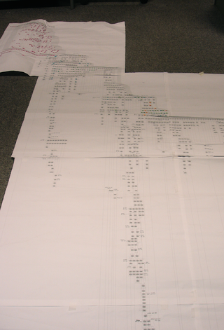
The Harris matrix is a tool used to depict the temporal succession of archaeological contexts and thus the sequence of depositions and surfaces on a 'dry land' archaeological site, otherwise called a 'stratigraphic sequence'. The matrix reflects the relative position and stratigraphic contacts of observable stratigraphic units, or contexts. It was developed in 1973 in Winchester, England, by Edward C. Harris.

<span class="mw-page-title-main">Plan (archaeology)</span>

In archaeological excavation, a plan is a drawn record of features and artifacts in the horizontal plane.

In archaeology, seriation is a relative dating method in which assemblages or artifacts from numerous sites in the same culture are placed in chronological order. Where absolute dating methods, such as radio carbon, cannot be applied, archaeologists have to use relative dating methods to date archaeological finds and features. Seriation is a standard method of dating in archaeology. It can be used to date stone tools, pottery fragments, and other artifacts. In Europe, it has been used frequently to reconstruct the chronological sequence of graves in a cemetery.

<span class="mw-page-title-main">Wheeler–Kenyon method</span> Method of archaeological excavation

The Wheeler–Kenyon method is a method of archaeological excavation. The technique originates from the work of Mortimer Wheeler and Tessa Wheeler at Verulamium (1930–35), and was later refined by Kathleen Kenyon during her excavations at Jericho (1952–58). The Wheeler–Kenyon system involves digging within a series of squares that can vary in size set within a larger grid. This leaves a freestanding wall of earth—known as a "balk"—that can range from 50 cm for temporary grids, and measure up to 2 metres in width for a deeper square. The normal width of a permanent balk is 1 metre on each side of a unit. These vertical slices of earth allow archaeologists to compare the exact provenance of a found object or feature to adjacent layers of earth ("strata"). During Kenyon's excavations at Jericho, this technique helped discern the long and complicated occupational history of the site. It was believed that this approach allowed more precise stratigraphic observations than earlier "horizontal exposure" techniques that relied on architectural and ceramic analysis.

<span class="mw-page-title-main">Phase (archaeology)</span>

In archaeology, a phase refers to the logical reduction of contexts recorded during excavation to nearly contemporary archaeological horizons that represent a distinct "phase" of previous land use. These often but not always will be a representation of a former land surface or occupation level and all associated features that were created into or from this point in time. A simplified description of phase would be that "a phase is a view of a given archaeological site as it would have been at time X".

<span class="mw-page-title-main">Relationship (archaeology)</span>

An archaeological relationship is the position in space and by implication, in time, of an object or context with respect to another. This is determined, not by linear measurement but by determining the sequence of their deposition – which arrived before the other. The key to this is stratigraphy.

<span class="mw-page-title-main">Single context recording</span>

Single context recording was initially developed by Ed Harris and Patrick Ottaway in 1976, from a suggestion by Laurence Keen. It was further developed by the Department of Urban Archaeology from where it was then exported, in the mid-1980s by Pete Clarke to the Scottish Urban Archaeological Trust and Nick Pearson to the York Archaeological Trust. It has become a popular system of recording and planning being used in many countries in Europe and in Lebanon, it is especially suited to the complexities of deep, typically urban, archaeology. Each excavated context is given a unique "context number" and is recorded by type on a context sheet and perhaps being drawn on a plan and/or a section. Depending on time constraints and importance contexts may also be photographed, but in this case a grouping of contexts and their associations are the purpose of the photography. Finds from each context are bagged and labelled with their context number and site code for later cross-reference work carried out post excavation. The height above sea level of pertinent points on a context, such as the top and bottom of a wall are taken and added to plans sections and context sheets. Heights are recorded with a dumpy level or total station by relation to the site temporary benchmark. Samples of deposits from contexts are sometimes also taken, for later environmental analysis or for scientific dating.

In archaeology, natural is a term to denote a layer (stratum) in the stratigraphic record where there is no evidence of human impact on the environment. While there may be "natural" layers interbedded with archaeologically interesting layers, such as when a site was abandoned for long periods between occupations, the top of the natural layer below which there is no anthropogenic activity on site, and thus where the archaeological record begins, is the point to terminate digging. Usually it is the underlying geological makeup of the site that was formed by geologic processes. It is the goal of complete excavation to remove the entirety of the archaeological record all the way to the "natural", leaving only the natural deposits of pre-human activity on site.

In archaeology a fill is the material that has accumulated or has been deposited into a cut feature such as ditch or pit of some kind of a later date than the feature itself. Fills are an important part of the archaeological record as their formation and composition can throw light on many aspects of archaeological study.

Sequence dating, an archaeological relative dating method, allows assemblages to be arranged in a rough serial order, which is then taken to indicate time. Sequence dating is a method of seriation developed by the Egyptologist Sir William Matthew Flinders Petrie. By linking styles of pottery with different time periods, he was able to establish the relative chronology of the site.

<span class="mw-page-title-main">Gatecliff Rockshelter</span> Archaeological site in the Great Basin area of the western United States

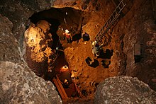
Gatecliff Rockshelter (26NY301) is a major archaeological site in the Great Basin area of the western United States that provides remarkable stratigraphy; it has been called the "deepest archaeological rock shelter in the Americas". Located in Mill Canyon of the Toquima Range in the Monitor Valley of central Nevada, Gatecliff Rockshelter has an elevation of 7,750 feet (2,360 m). David Hurst Thomas discovered Gatecliff Rockshelter in 1970 and began excavations in 1971. Full scale excavations occurred at Gatecliff Rockshelter for about seven field seasons in which nearly 33 feet (10 m) of sediments were exposed for a well-defined stratigraphic sequence. The well-preserved artifacts and undisturbed sediments at Gatecliff Rockshelter provides data and information have been applied to a range of research topics. Based on the analysis of the artifacts at Gatecliff Rockshelter, it can be determined that it was most likely a short-term field camp throughout prehistory. The latest evidence for human usage at Gatecliff occurs between ca. 5500 B.P. to 1250 B.P.

In the field of archaeology, a spit is a unit of archaeological excavation with an arbitrarily assigned measurement of depth and extent. It is a method of excavation employed without regard to the archaeological stratigraphy that may be identifiable at the archaeological site under investigation. The method of excavating in arbitrary spits is most frequently encountered at site excavations which lack any visible or reconstructable stratigraphy in the archaeological context, or when excavating through intrusive or fill deposits.

Ifri Oudadane is an archaeological site in the northeastern Rif region of Morocco. It is located on the southwestern coast of the Cape Three Forks on the Mediterranean Sea, and is one of the most important sites in the northwestern Maghreb region of Africa. Discovered during road construction, the site consists of a fairly large rock shelter above the modern coastline, the site has been excavated since 2006 by a team of Moroccan and German archaeologists. Although much is known about the transition of humans from hunter gatherer groups to food production in Europe and the Middle East, much of North Africa has not been researched. Ifri Oudadane is one of the first of such sites in North Africa. Dated to between 11000 and 5700 years BP, the site contains evidence that documents the shift of local inhabitants from hunter-gatherer groups to food producers. Such elements of change found at Ifri Oudadane include evidence of animal husbandry, domestication of legumes, and decoration of pottery. The site is known to contain the earliest dated crop in Northern Africa, a lentil.

This page is a glossary of archaeology, the study of the human past from material remains.

References

  1. "What Is Excavation?". Archaeological Excavations in Greece. 13 April 2012. Retrieved 9 July 2020.
  2. Emery, Katy Meyers (4 October 2011). "Archaeology 101: Artifact versus Feature". MSU Campus Archaeology Program. Retrieved 21 July 2020.
  3. Ashmore, Wendy; Sharer, Robert (2013). Discovering our past : a brief introduction to archaeology (6th ed.). New York: McGraw-Hill. ISBN   978-0-07-803491-6. OCLC   821067667.
  4. Kelly&Thomas (2011). Archaeology: down to earth (4th ed.). Belmont, Calif.: Wadsworth, Cengage Learning.
  5. Sharer, Robert J. (2003). Archaeology: Discovering our past (3rd ed.). Boston: McGraw-Hill Higher Education. pp. 61–63. ISBN   0-7674-2727-0. OCLC   50802481.
  6. Reeves, D.M. (1936), "Aerial photography and archaeology", American Antiquity, 2 (2): 102–07, doi:10.2307/275881, JSTOR   275881, S2CID   164041261
  7. 1 2 Bahn, Paul (1 August 2012). Archaeology: A Very Short Introduction. Oxford University Press. p. 18. doi:10.1093/actrade/9780199657438.001.0001. ISBN   978-0-19-965743-8.
  8. 1 2 3 Bahn, Paul (1 August 2012). Archaeology: A Very Short Introduction. Oxford University Press. pp. 8–12. doi:10.1093/actrade/9780199657438.001.0001. ISBN   978-0-19-965743-8.
  9. "Archaeology". Encyclopedia Britannica. Retrieved 13 July 2020.
  10. 1 2 "Learning Archaeology: Excavation: Choosing a Site: Development Led Excavation". www.pastperfect.org.uk. Archived from the original on 25 September 2020. Retrieved 21 July 2020.
  11. "What is Test Pit Excavation for Soil Evaluation and what is Its Purpose?". Metro Pits. 27 July 2017.
  12. Binford, Lewis (1978). "Dimensional analysis of behaviour & site structure: learning from an Eskimo hunting stand". American Antiquity. 40: 335.
  13. Brock, Terry (16 February 2010). "Archaeology 101: Reading Stratigraphy". MSU Campus Archaeology Program. Retrieved 21 July 2020.
  14. 1 2 Ashmore, Wendy (4 March 2013). Discovering our past : a brief introduction to archaeology. Sharer, Robert J. (Sixth ed.). New York. ISBN   978-0-07-803491-6. OCLC   821067667.{{cite book}}: CS1 maint: location missing publisher (link)
  15. "Dating Techniques In Archaeology". www.archaeologyexpert.co.uk. Retrieved 29 July 2020.
  16. 1 2 "Glossary". Archaeological Institute of America. Retrieved 29 July 2020.
  17. "Learning Archaeology: Excavation: Recording: Stratigraphy: Cut / Fills". www.pastperfect.org.uk. Retrieved 29 July 2020.
  18. "Stratigraphic Excavation". Archaeology Skills Passport. 14 June 2014. Retrieved 31 July 2020.
  19. Van Horn, D.M.; J. R. Murray; R. S. White (1986). "Some Techniques for Mechanical Excavation in Salvage Archaeology". Journal of Field Archaeology. 13 (2): 239–244. doi:10.1179/jfa.1986.13.2.239.
  20. "How to dig?". Past Perfect. Retrieved 4 September 2013.
  21. "PBS' Time Team America to Debut July 8 with Dig on Roanoke Island". First Colony Foundation. Archived from the original on 17 October 2013. Retrieved 10 October 2013.
  22. Hill, Rosemary (2009). Stonehenge. Profile Books. p. 201. ISBN   978-1861978806.
  23. Barker (1982). Techniques of Archaeological Excavation (2nd ed.). London: Batsford. ISBN   978-0713427387.
  24. Roosevelt; Cobb; Moss; Olson; Ünlüsoy (2015). "Excavation is Destruction Digitization: Advances in Archaeological Practice". Journal of Field Archaeology. 40 (3): 325–346. doi: 10.1179/2042458215Y.0000000004 . S2CID   109818432.
  25. "What is Archaeological Flotation?". Zagora Archaeological Project. 6 September 2019. Retrieved 29 July 2020.

Further reading