Related Research Articles
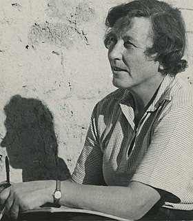
Dame Kathleen Mary Kenyon, was a British archaeologist of Neolithic culture in the Fertile Crescent. She led excavations of Tell es-Sultan, the site of ancient Jericho, from 1952 to 1958, and has been called one of the most influential archaeologists of the 20th century. She was Principal of St Hugh's College, Oxford, from 1962 to 1973 and studied herself at Somerville College, Oxford.

In archaeology, excavation is the exposure, processing and recording of archaeological remains. An excavation site or "dig" is the area being studied. These locations range from one to several areas at a time during a project and can be conducted over a few weeks to several years.

An archaeological site is a place in which evidence of past activity is preserved, and which has been, or may be, investigated using the discipline of archaeology and represents a part of the archaeological record. Sites may range from those with few or no remains visible above ground, to buildings and other structures still in use.

In archaeological excavation, a feature is a collection of one or more contexts representing some human non-portable activity, such as a hearth or wall. Features serve as an indication that the area in which they are found has been interfered with in the past, usually by humans.

In archaeology a section is a view in part of the archaeological sequence showing it in the vertical plane, as a cross section, and thereby illustrating its profile and stratigraphy. This may make it easier to view and interpret as it developed over time.

Prehistoric archaeology is a subfield of archaeology, which deals specifically with artefacts, civilisations and other materials from societies that existed before any form of writing system or historical record. Often the field focuses on ages such as the Stone age, Bronze age and Iron age, although it also encompasses periods such as the Neolithic. The study of prehistoric archaeology reflects the cultural concerns of modern society by showing interpretations of time between economic growth and political stability. It is related to other disciplines such as geology, biology, anthropology, historiography and palaeontology, although there are noticeable differences between the subjects they all broadly study to understand; the past, either organic or inorganic or the lives of humans. Prehistoric archaeology is also sometimes termed as anthropological archaeology because of its indirect traces with complex patterns.

Stratigraphy is a key concept to modern archaeological theory and practice. Modern excavation techniques are based on stratigraphic principles. The concept derives from the geological use of the idea that sedimentation takes place according to uniform principles. When archaeological finds are below the surface of the ground, the identification of the context of each find is vital in enabling the archaeologist to draw conclusions about the site and about the nature and date of its occupation. It is the archaeologist's role to attempt to discover what contexts exist and how they came to be created. Archaeological stratification or sequence is the dynamic superimposition of single units of stratigraphy, or contexts.

The Harris matrix is a tool used to depict the temporal succession of archaeological contexts and thus the sequence of depositions and surfaces on a 'dry land' archaeological site, otherwise called a 'stratigraphic sequence'. The matrix reflects the relative position and stratigraphic contacts of observable stratigraphic units, or contexts. The Matrix was developed in 1973 in Winchester, England, by Dr. Edward C. Harris.

In archaeological excavation, a plan is a drawn record of features and artifacts in the horizontal plane.

The Wheeler–Kenyon method is a method of archaeological excavation. The technique originates from the work of Mortimer Wheeler and Tessa Wheeler at Verulamium (1930–35), and was later refined by Kathleen Kenyon during her excavations at Jericho (1952–58). The Wheeler–Kenyon system involves digging within a series of squares that can vary in size set within a larger grid. This leaves a freestanding wall of earth—known as a "balk"—that can range from 50 cm for temporary grids, and measure up to 2 metres in width for a deeper square. The normal width of a permanent balk is 1 metre on each side of a unit. These vertical slices of earth allow archaeologists to compare the exact provenance of a found object or feature to adjacent layers of earth ("strata"). During Kenyon's excavations at Jericho, this technique helped discern the long and complicated occupational history of the site. It was believed that this approach allowed more precise stratigraphic observations than earlier "horizontal exposure" techniques that relied on architectural and ceramic analysis.

In archaeology, a phase refers to the logical reduction of contexts recorded during excavation to nearly contemporary archaeological horizons that represent a distinct "phase" of previous land use. These often but not always will be a representation of a former land surface or occupation level and all associated features that were created into or from this point in time. A simplified description of phase would be that "a phase is a view of a given archaeological site as it would have been at time X".
In archaeology, natural is a term to denote a layer (stratum) in the stratigraphic record where there is no evidence of human impact on the environment. While there may be "natural" layers interbedded with archaeologically interesting layers, such as when a site was abandoned for long periods between occupations, the top of the natural layer below which there is no anthropogenic activity on site, and thus where the archaeological record begins, is the point to terminate digging. Usually it is the underlying geological makeup of the site that was formed by geologic processes. It is the goal of complete excavation to remove the entirety of the archaeological record all the way to the "natural", leaving only the natural deposits of pre-human activity on site.
Richard Stockton MacNeish, known to many as "Scotty", was an American archaeologist. His fieldwork revolutionized the understanding of the development of agriculture in the New World and the prehistory of several regions of Canada, the United States and Central and South America. He pioneered new methods in fieldwork and materials analysis and brought attention to the importance of interdisciplinary collaboration. His legacy has influenced generations of archaeologists.

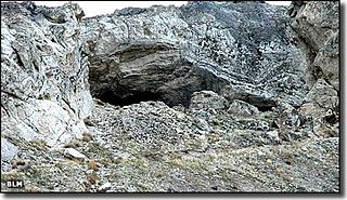
Gatecliff Rockshelter (26NY301) is a major archaeological site in the Great Basin area of the western United States that provides remarkable stratigraphy; it has been called the "deepest archaeological rock shelter in the Americas". Located in Mill Canyon of the Toquima Range in the Monitor Valley of central Nevada, Gatecliff Rockshelter has an elevation of 7,750 feet (2,360 m). David Hurst Thomas discovered Gatecliff Rockshelter in 1970 and began excavations in 1971. Full scale excavations occurred at Gatecliff Rockshelter for about seven field seasons in which nearly 33 feet (10 m) of sediments were exposed for a well-defined stratigraphic sequence. The well-preserved artifacts and undisturbed sediments at Gatecliff Rockshelter provides data and information have been applied to a range of research topics. Based on the analysis of the artifacts at Gatecliff Rockshelter, it can be determined that it was most likely a short-term field camp throughout prehistory. The latest evidence for human usage at Gatecliff occurs between ca. 5500 B.P. to 1250 B.P.

Archaeology or archeology is the scientific study of human activity through the recovery and analysis of material culture. The archaeological record consists of artifacts, architecture, biofacts or ecofacts, sites, and cultural landscapes. Archaeology can be considered both a social science and a branch of the humanities. It is usually considered an independent academic discipline, but may also be classified as part of anthropology, history or geography.
Lovelock Cave (NV-Ch-18) is a North American archaeological site previously known as Sunset Guano Cave, Horseshoe Cave, and Loud Site 18. The cave is about 150 feet long and 35 feet wide. Lovelock Cave is one of the most important classic sites of the Great Basin region because the conditions of the cave are conducive to the preservation of organic and inorganic material. The cave was placed on the National Register of Historic Places on May 24, 1984. It was the first major cave in the Great Basin to be excavated, and the Lovelock Cave people are part of the University of California Archaeological Community's Lovelock Cave Station.
Tessa Wheeler was an archaeologist who made a significant contribution to excavation techniques and contributed to the setting up of major British archaeological institutions after the Second World War.
This page is a glossary of archaeology, the study of the human past from material remains.
The Quad site is a series of Paleoindian sites and localities in Limestone County near Decatur, Alabama. It was first reported by Frank Soday in 1954, and later findings were also documented by James Cambron, David Hulse and Joe Wright and Cambron and Hulse. The Quad Locale can seldom be viewed at current lake levels, even during normal winter pool, due to extensive erosion, but is considered one of the most important and well known Paleoindian sites in the Southeastern United States.

Modern archaeology is the discipline of archaeology which contributes to excavations.
References
- Barker, Philip (1993). Techniques of archaeological excavation (3rd ed.). London: Batsford.
- Flannery, Kent V. (1976). The Early Mesoamerican Village. New York: Academic Press.
- Hester, T.R.; R.F. Heizer; J.A. Graham (1975). Field Methods in Archaeology. Palo Alto, CA: Mayfield Publishing.
- Hole, F.; R.F. Heizer (1973). An Introduction to Prehistoric Archaeology . New York: Holt, Rinehart & Winston.
- Roskams, Steve (2001). Excavation. Cambridge and New York: Cambridge University Press. ISBN 0-521-35534-6. OCLC 44172871.
- Wheeler, Mortimer (1954). Archaeology from the Earth. London: Oxford University Press.