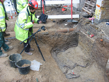
In archaeology, excavation is the exposure, processing and recording of archaeological remains. An excavation site or "dig" is the area being studied. These locations range from one to several areas at a time during a project and can be conducted over a few weeks to several years.

An archaeological site is a place in which evidence of past activity is preserved, and which has been, or may be, investigated using the discipline of archaeology and represents a part of the archaeological record. Sites may range from those with few or no remains visible above ground, to buildings and other structures still in use.
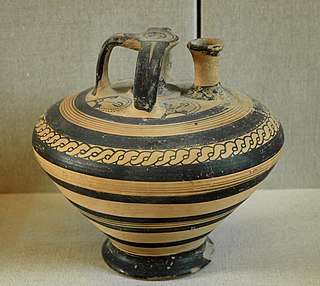
An artifact or artefact is a general term for an item made or given shape by humans, such as a tool or a work of art, especially an object of archaeological interest. In archaeology, the word has become a term of particular nuance and is defined as an object recovered by archaeological endeavor, which may be a cultural artifact having cultural interest.

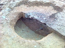
In archaeology a posthole or post-hole is a cut feature used to hold a surface timber or stone. They are usually much deeper than they are wide; however, truncation may not make this apparent. Although the remains of the timber may survive, most postholes are mainly recognisable as circular patches of darker earth when viewed in plan. Archaeologists can use their presence to plot the layout of former structures, as the holes may define its corners and sides. Construction using postholes is known as earthfast or post in ground construction.

Stratigraphy is a key concept to modern archaeological theory and practice. Modern excavation techniques are based on stratigraphic principles. The concept derives from the geological use of the idea that sedimentation takes place according to uniform principles. When archaeological finds are below the surface of the ground, the identification of the context of each find is vital in enabling the archaeologist to draw conclusions about the site and about the nature and date of its occupation. It is the archaeologist's role to attempt to discover what contexts exist and how they came to be created. Archaeological stratification or sequence is the dynamic superimposition of single units of stratigraphy, or contexts.
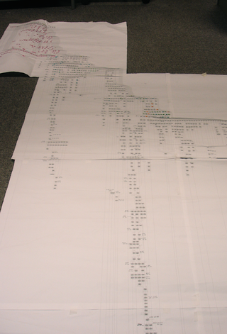
The Harris matrix is a tool used to depict the temporal succession of archaeological contexts and thus the sequence of depositions and surfaces on a 'dry land' archaeological site, otherwise called a 'stratigraphic sequence'. The matrix reflects the relative position and stratigraphic contacts of observable stratigraphic units, or contexts. It was developed in 1973 in Winchester, England, by Dr. Edward C. Harris.

In archaeological excavation, a plan is a drawn record of features and artifacts in the horizontal plane.
In archaeology a fill is the material that has accumulated or has been deposited into a cut feature such as ditch or pit of some kind of a later date than the feature itself. Fills are an important part of the archaeological record as their formation and composition can throw light on many aspects of archaeological study.
The Klasies River Caves are a series of caves located east of the Klasies River Mouth on the Tsitsikamma coast in the Humansdorp district of Eastern Cape Province, South Africa. The Klasies River Main (KRM) site consists of 3 main caves and 2 shelters located within a cliff on the southern coast of the Eastern Cape. The site provides evidence for developments in stone tool technology, evolution of modern human anatomy and behavior, and changes in paleoecology and climate in Southern Africa based on evidence from plant remains.

In archaeology, a biofact is any organic material including flora or fauna material found at an archaeological site that has not been technologically altered by humans yet still has cultural relevance. Biofacts can include but are not limited to plants, seeds, pollen, animal bones, insects, fish bones and mollusks. The study of biofacts, alongside other archaeological remains such as artifacts are a key element to understanding how past societies interacted with their surrounding environment and with each other. Biofacts also play a role in helping archaeologists understand questions of subsistence and reveals information about the domestication of certain plant species and animals which demonstrates, for example, the transition from a hunter-gatherer society to a farming society.
The Florisbad archaeological and paleontological site is a provincial heritage site in Brandfort in the Free State province of South Africa. The most notable find at this site is the Florisbad Skull, the partial skull of an early human species that was discovered in 1932.
The Cherry Creek Rockshelter is an archaeological site in central Colorado, located within modern-day Castlewood Canyon State Park near Franktown, Colorado. Current research indicates that it was used by Native American inhabitants beginning in the Archaic period. The site is situated on the Palmer Divide, which allowed for a unique prehistoric environment that contributed to an abundance of food and water sources, as well as lithic materials for tool-making. These factors, combined with the structure and situation of the shelter itself, made the site a particularly attractive environment for prehistoric peoples to settle in. Archaeological study of the site began in 1955, with the most current original research concluding in 2002.
Porac, Pampanga contains areas in and near Babo Balukbuk in Porac, Philippines that have strong indication of human habitation, according to investigations published on the University of the Philippines Archaeological Studies Program website. Later test excavations confirmed this conclusion through the presence of materials dated around the 12th century to the 17th century C.E.
Melkhoutboom Cave is an archaeological site dating to the Later Stone Age, located in the Zuurberg Mountains, Cape Folded Mountain Belt, Sarah Baartman District Municipality in the Eastern Cape Province of South Africa.
This page is a glossary of archaeology, the study of the human past from material remains.

The Asahi Shell Midden is an archaeological site consisting of a shell midden and the remains of an adjacent Jōmon period settlement located in the Asahioka neighborhood the city of Himi, Toyama Prefecture in the Hokuriku region of Japan. The midden was designated a National Historic Site of Japan in 1922.
The Gentleman Farm site is located in LaSalle County, Illinois, on the Illinois River. It is a multi-component site with the main occupation being a Langford tradition component of Upper Mississippian affiliation.
The Catoma Creek site (1MT209) in Alabama is near the Alabama River's main tributary stream. The creek was named due to its proximity to the Catoma Creek within its floodplain. Its existence is marked by the Middle Woodland period, which occurred in Alabama from 200 CE - 500 CE. Catoma Creek is considered to be one of Cobb City's "Swamp Sites," which occupy the surrounding areas of the upper river valley in Alabama. These sites have collectively served as channels for the culture and lifestyle of the neighbouring communities. At the Cobb's Swamp sites, the Catoma Creek site has received the most in-depth examination. Excavations of Catoma Creek Site have uncovered a considerable number of remains, including artefacts and structures that provide insight into the culture and daily life of residing communities.

The Yamazaki Shell Midden is an archaeological site in the Yamazaki-Kaizuka neighborhood of the city of Noda, Chiba Prefecture, in the Kantō region of Japan containing a Jōmon period shell midden and settlement ruin. The site was designated a National Historic Site of Japan in 1976, with the area under designation expanded in 1995.

The Nakazato Shell Midden is an archaeological site in the Kaminakazato neighborhood of Kita-ku, Tokyo, in the Kantō region of Japan containing a middle Jōmon period shell midden, extending about 1.1 kilometers from Kami-Nakazato Station to Tabata Station. The midden was designated a National Historic Site of Japan in 2000.