Thornborough Henges

Last updated

The three henges of the Thornborough Henges complex, looking south Thornborough Henge.jpg
The three henges of the Thornborough Henges complex, looking south

The Thornborough Henges are an ancient monument complex that includes the three aligned henges that give the site its name. They are located on a raised plateau above the River Ure near the village of Thornborough in North Yorkshire, England. The site includes many large ancient structures including a cursus, henges, burial grounds and settlements.

Contents

They are thought to have been part of a Neolithic and Bronze Age 'ritual landscape' comparable to Salisbury Plain and date from between 3500 and 2500 BC. The monument complex has been called 'The Stonehenge of the North'. Historic England considers its landscape comparable in ceremonial importance to better known sites such as Stonehenge, Avebury, and Orkney.

Concern over the impact on the ritual landscape of quarrying by Tarmac in the 21st century, led to negotiations between Tarmac and Historic England. Following an agreement originally reached in 2016, the two henges owned by Tarmac, as well as surrounding land owned by local company Lightwater Holdings, passed into the control of Historic England in 2023. The site is now managed by English Heritage and is publicly accessible. The third henge remained in private ownership at the time of the original agreement but in February 2024 English Heritage announced that it had acquired it.

Location

The Thornborough Henges are located on a plateau above the River Ure near the village of Thornborough in North Yorkshire, England. [1]

Cursus

The cursus is the oldest and largest ancient monument at Thornborough. [2] It is almost a mile in extent and runs from Thornborough village, under the (later) central henge and terminates close to the River Ure in a broadly east/west alignment, 8 kilometres (5 mi) north-west of Ripon. [3]

Cursuses are perhaps the most enigmatic of ancient monuments. They typically comprise two parallel ditches, the larger of which can be a mile or more in extent, cut to create a "cigar-shaped" enclosure. Typically, burial mounds and mortuary enclosures are found alongside cursus monuments, indicating that they probably had a ceremonial function. [4] Its age and status, alongside other ancient monuments of its kind, has led to the site being labelled as "the Stonehenge of the North". [5]

Henges

The monument complex has been called 'The Stonehenge of the North'. [6] Historic England considers its landscape comparable in ceremonial importance to better known sites such as Stonehenge, Avebury, and Orkney. [7]

The three henges are almost identical in size and composition, each having a diameter of approximately 240 metres (790 ft) and two large entrances situated directly opposite each other. [8] The henges are located around 550 metres (1,800 ft) apart on an approximate northwest-southeast alignment, although there is a curious 'dogleg' in the layout. Altogether, the monument extends for more than a mile.

Archaeological excavation of the central henge has taken place. It has been suggested that its banks were covered with locally mined gypsum, with the resulting white sheen being striking and visible for miles around. [4] A double alignment of pits, possibly evidence of a timber processional avenue, extends from the southern henge.

The 'dogleg' in the layout appears to cause the layout of the henges to mirror the three stars of Orion's Belt. The exact purpose of the henges is unclear though archaeological finds suggest that they served economic and social purposes as well as astronomical ones. [9] It also reflects the different perpendicular alignments of midwinter sunset and midsummer sunrise. [10] One of the legs also aligns, via another henge site at Nunwick with the Devil's Arrows 17.7km away at Boroughbridge. [11] [12]

The Northern henge is currently overgrown with trees but is one of the best preserved henges in Britain. The Central and Southern henges are in poorer condition although the banks of the henges are still quite prominent, especially in the case of the Central henge. To gain a full appreciation of the scale of the monument it is best viewed from the air. Thornborough Henges is a scheduled monument. [13]

Beltane

The May King and Queen, Thornborough Central Henge, Beltane 1 May 2005 MayKingandQueen.jpg
The May King and Queen, Thornborough Central Henge, Beltane 1 May 2005

All three of the Thornborough henges and the narrow strip of land connecting them are scheduled monuments. However, prior to the 2023 developments (see below) the owners of the site did not generally permit public access. Since 2004 an exception was made by Tarmac in relation to their land which allowed people to attend an annual event in celebration of the Gaelic festival of Beltane. [14]

Quarrying and current status

Extensive quarrying has impacted much of the monument's setting to the north and west of the henges. The site lies within the wider Nosterfield quarry area being exploited for gravel by Tarmac Northern Ltd. In the early 21st century Tarmac planned to extend its quarrying operations to a 45-hectare (110-acre) site less than a mile east of the henges known as 'Ladybridge Farm'. [15] Preliminary investigations of this area of land to discern its archaeological significance suggested that it may have been a location of ritual Neolithic encampments, possibly used by those people who built or visited the henges. Opponents of the plan claimed that if permission was granted for this area to be quarried, much of the remaining contextual information about the henges would be lost. A campaign led by local people and concerned archaeologists attempted to persuade Tarmac and North Yorkshire County Council to guarantee the protection of the area. British planning and archaeology guidelines prefer preservation in situ of archaeological remains. In cases where this is not possible, such as quarrying, preservation by record is an option, involving archaeological excavation. Campaigners argued that further excavation and subsequent quarrying will destroy the ritual landscape completely.

In 2002 Tarmac Northern Ltd. expressed an intention to apply for planning permission to quarry Thornborough Moor, thus intending to quarry right up to the edge of the designated scheduled monument area, which caused what The Times labelled as "unprecedented protests", and a 10,000 signature petition against the proposal. [16] In March 2005, Tarmac stated it would not seek to apply for planning permission to quarry this site for at least ten years, the period covered by North Yorkshire County Council's Minerals Plan.

In February 2006 North Yorkshire County Council turned down Tarmac's application to expand quarrying to the Ladybridge Farm site. Later in 2006 Tarmac submitted a revised planning application to North Yorkshire County Council. The revised application for Ladybridge, which is adjacent to the Nosterfield Quarry, reduced the proposed area for sand and gravel extraction from 45 hectares to 31 hectares, avoiding the south west section of the site to address concerns raised about archaeology. The application was approved in February 2007.

Late in 2007 campaign group Friends of Thornborough requested a judicial review of the planning permission due to a number of procedural irregularities. In response, North Yorkshire County Council ruled the permission to be "fatally flawed," and withdrew the permission previously granted.

In November 2016, North Yorkshire County Council’s planning committee agreed with the owners Tarmac to approve further quarrying in return for preserving[ clarification needed ] the site of the Thornborough Henges and 90 acres of surrounding land, which would eventually be handed over to a public body. This agreement saw control of the two henges on land owned by Tarmac pass to Historic England in February 2023. The site is operated by English Heritage and will enable public access. It will join the National Heritage Collection of English Heritage properties. [17] [18] In February 2024 English Heritage announced that it had acquired the third henge from its private owners. [19]

Related Research Articles

<span class="mw-page-title-main">Stonehenge</span> Ancient monument in England

Stonehenge is a prehistoric megalithic structure on Salisbury Plain in Wiltshire, England, two miles (3 km) west of Amesbury. It consists of an outer ring of vertical sarsen standing stones, each around 13 feet (4.0 m) high, seven feet (2.1 m) wide, and weighing around 25 tons, topped by connecting horizontal lintel stones. Inside is a ring of smaller bluestones. Inside these are free-standing trilithons, two bulkier vertical sarsens joined by one lintel. The whole monument, now ruinous, is aligned towards the sunrise on the summer solstice and sunset on the winter solstice. The stones are set within earthworks in the middle of the densest complex of Neolithic and Bronze Age monuments in England, including several hundred tumuli.

<span class="mw-page-title-main">Ring of Brodgar</span> A neolithic stone circle in Orkney, Scotland

The Ring of Brodgar is a Neolithic henge and stone circle about 6 miles north-east of Stromness on Mainland, the largest island in Orkney, Scotland. It is part of the UNESCO World Heritage Site known as the Heart of Neolithic Orkney.

<span class="mw-page-title-main">Woodhenge</span> Neolithic henge and timber circle monument near Stonehenge

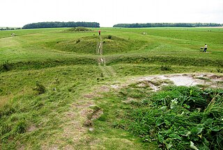
Woodhenge is a Neolithic Class II henge and timber circle monument within the Stonehenge World Heritage Site in Wiltshire, England. It is 2 miles (3.2 km) northeast of Stonehenge, in Durrington parish, just north of the town of Amesbury.

<span class="mw-page-title-main">Henge</span> Type of Neolithic earthwork

There are three related types of Neolithic earthwork that are all sometimes loosely called henges. The essential characteristic of all three is that they feature a ring-shaped bank and ditch, with the ditch inside the bank. Because the internal ditches would have served defensive purposes poorly, henges are not considered to have been defensive constructions. The three henge types are as follows, with the figure in brackets being the approximate diameter of the central flat area:

  1. Henge. The word henge refers to a particular type of earthwork of the Neolithic period, typically consisting of a roughly circular or oval-shaped bank with an internal ditch surrounding a central flat area of more than 20 m (66 ft) in diameter. There is typically little if any evidence of occupation in a henge, although they may contain ritual structures such as stone circles, timber circles and coves. Henge monument is sometimes used as a synonym for henge. Henges sometimes, but by no means always, featured stone or timber circles, and circle henge is sometimes used to describe these structures. The three largest stone circles in Britain are each within a henge. Examples of henges without significant internal monuments are the three henges of Thornborough Henges. Although having given its name to the word henge, Stonehenge is atypical in that the ditch is outside the main earthwork bank.
  2. Hengiform monument. Like an ordinary henge, except the central flat area is between 5 and 20 m (16–66 ft) in diameter, they comprise a modest earthwork with a fairly wide outer bank. The terms mini-henge or Dorchester henge are sometimes used as synonyms for hengiform monument. An example is the Neolithic site at Wormy Hillock Henge.
  3. Henge enclosure. A Neolithic ring earthwork with the ditch inside the bank, with the central flat area having abundant evidence of occupation and usually being more than 300 m (980 ft) in diameter. Some true henges are as large as this, but lack evidence of domestic occupation. Super-henge or superhenge is sometimes used as a synonym for a henge enclosure. However, sometimes the term is used to indicate size alone rather than use, e.g. "Marden henge ... is the least understood of the four British 'superhenges' ".
<span class="mw-page-title-main">Arbor Low</span> Neolithic henge in Derbyshire, England

Arbor Low is a well-preserved Neolithic henge in the Derbyshire Peak District, England. It lies on a Carboniferous Limestone plateau known as the White Peak area. The monument consists of a stone circle surrounded by earthworks and a ditch.

<span class="mw-page-title-main">Cursus</span> Neolithic earthwork

Cursuses are monumental Neolithic structures resembling ditches or trenches in the islands of Great Britain and Ireland. Relics found within them indicate that they were built between 3400 and 3000 BC, making them among the oldest monumental structures on the islands. The name 'cursus' was suggested in 1723 by William Stukeley, the antiquarian, who compared the Stonehenge cursus to a Roman chariot-racing track, or circus.

<span class="mw-page-title-main">Durrington Walls</span> Late Neolithic palisaded enclosure

Durrington Walls is the site of a large Neolithic settlement and later henge enclosure located in the Stonehenge World Heritage Site in England. It lies 2 miles (3.2 km) north-east of Stonehenge in the parish of Durrington, just north of Amesbury in Wiltshire. The henge is the second-largest Late Neolithic palisaded enclosure known in the United Kingdom, after Hindwell in Wales.

<span class="mw-page-title-main">The Sanctuary</span> Prehistoric site in Wiltshire, England

The Sanctuary was a stone and timber circle near the village of Avebury in the south-western English county of Wiltshire. Excavation has revealed the location of the 58 stone sockets and 62 post-holes. The ring was part of a tradition of stone circle construction that spread throughout much of Britain, Ireland, and Brittany during the Late Neolithic and Early Bronze Age, over a period between 3300 and 900 BCE. The purpose of such monuments is unknown, although archaeologists speculate that the stones represented supernatural entities for the circle's builders.

<span class="mw-page-title-main">Brú na Bóinne</span> Archaeological site in County Meath, Ireland

Brú na Bóinne, also called the Boyne Valley tombs, is an ancient monument complex and ritual landscape in County Meath, Ireland, located in a bend of the River Boyne. It is one of the world's most important Neolithic landscapes, comprising at least ninety monuments including passage tombs, burial mounds, standing stones and enclosures. The site is dominated by the passage tombs of Newgrange, Knowth and Dowth, built during the 32nd century BC. Together these have the largest assemblage of megalithic art in Europe. The associated archaeological culture is called the "Boyne culture".

Yorkshire is a historic county of England, centred on the county town of York. The region was first occupied after the retreat of the ice age around 8000 BC. During the first millennium AD it was inhabited by celtic Britons and occupied by Romans, Angles and Vikings. The name comes from "Eborakon" an old Brythonic name which probably derives from "Efor" or "the place of the yew-trees." Many Yorkshire dialect words and aspects of pronunciation derive from old Norse due to the Viking influence in this region. The name "Yorkshire", first appeared in writing in the Anglo-Saxon Chronicle in 1065. It was originally composed of three sections called Thrydings, subsequently referred to as Ridings.

<span class="mw-page-title-main">Devil's Arrows</span> Standing stones near Boroughbridge, North Yorkshire, England

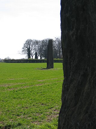
The Devil's Arrows are four standing stones or menhirs in an alignment approximately 660 feet (200 m) to the east of the A1(M), adjacent to Roecliffe Lane, Boroughbridge in North Yorkshire, England, near to where the A1 road now crosses the River Ure. They have been designated as a scheduled monument since 1923.

Stonehenge, Avebury and Associated Sites is a UNESCO World Heritage Site (WHS) in Wiltshire, England. The WHS covers two large areas of land separated by about 24 kilometres (15 mi), rather than a specific monument or building. The sites were inscribed as co-listings in 1986. Some large and well known monuments within the WHS are listed below, but the area also has an exceptionally high density of small-scale archaeological sites, particularly from the prehistoric period. More than 700 individual archaeological features have been identified. There are 160 separate scheduled monuments, covering 415 items or features.

<span class="mw-page-title-main">Mayburgh Henge</span> Neolithic henge in Cumbria, England

Mayburgh Henge is a large prehistoric monument in the county of Cumbria in northern England. The henge is in the care of English Heritage and is a Scheduled Ancient Monument. It is 400 metres from King Arthur's Round Table Henge.

<span class="mw-page-title-main">West Tanfield</span> Village and civil parish in North Yorkshire, England

West Tanfield is a village and civil parish in the Hambleton district of North Yorkshire, England. The village is situated approximately six miles north of Ripon on the A6108, which goes from Ripon to Masham and Wensleydale. The parish includes the hamlets of Nosterfield, Thornborough and Binsoe.

The Stonehenge Riverside Project was a major Arts and Humanities Research Council-funded archaeological research study of the development of the Stonehenge landscape in Neolithic and Bronze Age Britain. In particular, the project examined the relationship between the Stones and surrounding monuments and features, including the River Avon, Durrington Walls, the Cursus, the Avenue, Woodhenge, burial mounds, and nearby standing stones. The project involved a substantial amount of fieldwork and ran from 2003 to 2009. It found that Stonehenge was built 500 years earlier than previously thought. The monument is believed to have been built to unify the peoples of Britain. It also found a previously unknown stone circle, Bluestonehenge.

<span class="mw-page-title-main">Vespasian's Camp</span> Iron Age hillfort in Wiltshire, England

Vespasian's Camp is an Iron Age hillfort just west of the town of Amesbury, Wiltshire, England. The hillfort is less than 3 kilometres (2 mi) from the Neolithic and Bronze Age site of Stonehenge, and was built on a hill next to the Stonehenge Avenue; it has the River Avon on its southern side and the A303 road on its northern edge. The site is a scheduled monument and lies within the boundaries of the Stonehenge World Heritage Site.

<span class="mw-page-title-main">Stonehenge Cursus</span> Neolithic monument in Wiltshire, England

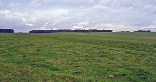
The Stonehenge Cursus is a large Neolithic cursus monument on Salisbury plain, near to Stonehenge in Wiltshire, England. It is roughly 3 kilometres (1.9 mi) long and between 100 metres (330 ft) and 150 metres (490 ft) wide. Excavations in 2007 dated the construction of the earthwork to between 3630 and 3375 BCE, several hundred years before the earliest phase of Stonehenge in 3000 BC. The cursus, along with adjacent barrows and the nearby 'Lesser Cursus' are part of the National Trust's Stonehenge Landscape property, and is within the Stonehenge and Avebury World Heritage Site.

<span class="mw-page-title-main">Cursus Barrows</span> Barrow cemetery in England

The Cursus Barrows is the name given to a Neolithic and Bronze Age round barrow cemetery lying mostly south of the western end of the Stonehenge Cursus, in Wiltshire, England. The cemetery contains around 18 barrows scattered along an east-to-west ridge, although some of the mounds are no longer visible. The Cursus Barrows can be seen just north of the route between the Stonehenge Visitor Centre and Stonehenge.

<span class="mw-page-title-main">Devil's Quoits</span> Neolithic henge in Oxfordshire, England

The Devil's Quoits is a henge and stone circle to the south of the village of Stanton Harcourt in Oxfordshire, England. The site is believed to be from the Neolithic Period, between 4000 and 5000 years old, and is a Scheduled Ancient Monument. The Quoits were restored between 2002 and 2008, with stones which had been knocked over or had fallen over being re-erected, and the surrounding earthworks rebuilt.

The Catholme ceremonial complex is an archaeological site of the Neolithic period in Staffordshire, England, near Barton-under-Needwood. It is a scheduled monument.

References

  1. "History of Thornborough Henges". English Heritage. Retrieved 5 February 2023.
  2. Cummings, Vicki (December 2014). "Great monuments of the north and south - Jan Harding (ed.). Cult, religion and pilgrimage: archaeological investigations at the Neolithic and Bronze Age monument complex of Thornborough, North Yorkshire". Antiquity. 88 (342): 1,323. doi:10.1017/S0003598X00115510. S2CID   164134977.
  3. Thomas 1955, p. 425.
  4. 1 2 Thomas 1955, p. 429.
  5. Stephens, Max (3 February 2023). "Stonehenge of the North open to the public for the first time". The Daily Telegraph. No. 52, 168. p. 8. ISSN   0307-1235.
  6. "Yorkshire's 'Stonehenge of the North' gifted to the nation". BBC News. 3 February 2023. Retrieved 4 February 2023.
  7. Historic England. "Thornborough Henges (52056)". Research records (formerly PastScape). Retrieved 11 January 2019.
  8. Thomas 1955, p. 432.
  9. Harding, Jan (2015). The Neolithic and Bronze Age Monument Complex of Thornborough, North Yorkshire, UK. p. 1246. Bibcode:2015hae..book.1239H. doi:10.1007/978-1-4614-6141-8_119. ISBN   978-1-4614-6140-1.{{cite book}}: |journal= ignored (help)
  10. Beltaine Celebrations at Thornborough Central henge
  11. Ward, Norrie, Yorkshire's Mine, (1969)
  12. Pennick, N. & Devereux, P., Lines on the Landscape, (1989), pp.69-70; 233-234
  13. Historic England. "Earth circles, cursus, pit alignments and burial sites near Nosterfield and Thornborough, including Centre Hill round barrow (Grade SM) (1004912)". National Heritage List for England . Retrieved 9 February 2024.
  14. "Thornborough Henges". Yorkshire Guide. Retrieved 3 February 2023.
  15. Hammond, Norman (24 August 2004). "Battle to preserve Thornborough henges". The Times. Retrieved 11 January 2019.
  16. Hammond, Norman (24 August 2004). "Battle to preserve Thornborough henges". The Times. No. 68, 162. p. 29. ISSN   0140-0460.
  17. "Yorkshire's 'Stonehenge of the North' gifted to the nation". BBC News. 3 February 2023. Retrieved 3 February 2023.
  18. Brown, Mark (3 February 2023). "Forgotten 'Stonehenge of the north' given to nation by construction firm". The Guardian. Retrieved 3 February 2023.
  19. "Thornborough Henges: Prehistoric Yorkshire sites reunited under one owner". BBC News. 9 February 2024. Retrieved 9 February 2024.

Sources

54°12′36″N1°33′50″W / 54.21000°N 1.56389°W / 54.21000; -1.56389