Aerial archaeology

Last updated

Aerial archaeology is the study of archaeological remains by examining them from a higher altitude. In present day, this is usually achieved by satellite images or through the use of drones.

Contents

Details

Aerial Archaeology involves interpretation and image analysis of photographic (and other kinds of images), in field research to understand archaeological features, sites, and landscapes. It enables exploration and examination of context and large land areas, on a scale unparalleled by other archaeological methods. The AARG (Aerial Archaeology Research Group) boasts that 'more archaeological features have been found worldwide through aerial photography than by any other means of survey'. [1]

Aerial archaeological survey combines data collection and data analysis. [2] The umbrella term 'Aerial images' includes traditional aerial photographs, satellite images, multispectral data (which captures image data within specific wavelength ranges across the electromagnetic spectrum [3] ) and hyperspectral data (similar to multi-spectral data, but more detailed).

A vast bank of aerial images exists, with parts freely available online or at specialist libraries. These are often vertical images taken for 'Area Survey', by aircraft or satellite (not necessarily for archaeological reasons). Each year a small number of aerial images are taken by archaeologists during prospective surveys. [4]

Aerial Archaeology is used for a wide range of archaeological purposes: discovery of new sites; site recording; determining where to excavate; mapping individual sites; monitoring sites, etc. Aerial Images form the foundation of archaeological landscape mapping and the ability to study large areas is often the only possible using aerial resources. [5]

Through the aid of vast data banks of satellite and other aerial imagery, archaeologists have access to resources that allow them to carry out these tasks.

In places yet to be documented (or where maps are considered confidential), satellite imagery is vital to providing base maps for excavation. [6]

For data analysis, aerial images must be analysed and interpreted using specialised skill-sets. This includes an understanding of formation processes as well as contemporary history and landscape history. [7] Often aerial archaeology will be carried out using computer programmes (such as Geographic Information System) aiding interpretation.

Despite Aerial photography seeming methodologically objective and empirical, there is possible subjectivity that merits consideration, e.g. bias when interpreting images, and errors such as conflating interpretation with description. [8] In 'From the air: Understanding Aerial Archaeology', Brophy and Cowley argue that 'the individual plays a major role in creating the archaeological record' [9] in aerial archaeology, more than in other fields. For example, in aviation archaeology, subjective decisions include deciding where and when to fly, what targets to examine, what to photograph and how to photograph it, what to catalogue, and how to interpret the data.

Aerial archaeological photograph of the "Nazca monkey" in Peru Nazca monkey.jpg
Aerial archaeological photograph of the "Nazca monkey" in Peru
Aerial photograph of Barzan, showing the archaeological traces of a neolithic and later, the Gallo-Roman city of Novioregum Barzan.jpg
Aerial photograph of Barzan, showing the archaeological traces of a neolithic and later, the Gallo-Roman city of Novioregum

Background

Aerial archaeology is a well-established discipline dates back to over 80 years ago . [7]

The advantages of gaining a good aerial view of the ground have been long appreciated by archaeologists: a high viewpoint permits a better appreciation of fine details and their relationships within the wider site context. Early investigators attempted to gain bird's eye views of sites using hot air balloons, scaffolds or cameras attached to kites. Given the military importance placed on aerial photography during the First and Second World Wars, archaeologists were able to use the technique more effectively to discover and record archaeological sites

Large sites could, for the first time, be viewed accurately, in their entirety, within their landscape context. This aided the production of drawn plans and inspired archaeologists to look beyond the discrete monument and to appreciate a site's role within its setting.

Brophy and Cowley argue that 'recording techniques in anyone country or region are bound up in archaeological tradition that are heavily influenced by social and political contexts'. [10] Thus, aerial photography is recognised as a key part of archaeological survey in Britain, partly because it has strong local roots, especially through the RAF. However, this is not true everywhere.

Pioneers of aerial archaeology include:

Methods

Identifying archaeological features from above

Certain archaeological features are more visible from the air than on the ground due to their nature.

A key concept behind interpretation in aerial archaeology is that formation processes affect site features differently after abandonment. For a site to be detected by a remote sensing method, one would expect alterations to the soil or subsoil e.g. ditches, pits, banks, mounds, walls etc. which often are visible in relief. [11]

Tiny differences in ground conditions caused by buried features can be emphasised by a number of factors and viewed from the air:

Aerial photography

Aerial photographs can be categorised by oblique images and vertical images.

Oblique Images

Oblique images are taken at an angle, allowing sunlight to highlight physical features on the ground through shadow. [11]

These are often taken intentionally to observe something of potential archaeological significance. The day and time of year are essential for the most revealing images. Furthermore, features must be recognised before being photographed.

Vertical images

Vertical images are taken with no deviation from a perpendicular angle (the image looks straight down). These make up the majority of images in the vast public (and private) image catalogues used by archaeologists. Vertical images record entire landscapes and are often used for site discovery, as well as landscape survey, placing sites in their wider context, and mapping larger areas. [1]

For a three-dimensional effect, an overlapping pair of vertical photographs, taken from slightly offset positions, can be viewed stereoscopically.

Other

Other methods of photographic aerial archaeology include : drones, UAV kites or balloons. It is increasingly popular to have drones carry instruments (such as thermal cameras) and survey by taking 'scores of pictures that produce an overlapping set, recording a site, feature or excavation from all angles'. [12] These are then used alongside structures from motion software (SFM) to create 3D models.

Kite aerial thermogram revealing features on/under a grassed playing field. Thermal inertia and differential transpiration/evaporation are involved. (https://www.facebook.com/KARSensing/) Kite aerial thermogram of Statford Court Playingfields, Stroud, Gloucestershire, UK.jpg
Kite aerial thermogram revealing features on/under a grassed playing field. Thermal inertia and differential transpiration/evaporation are involved. (https://www.facebook.com/KARSensing/)

Visible wavelength satellite imagery

LIDAR

Lynchet system near Bishopstone in Wiltshire. LIDAR technology used to map topography. El Tintal Mano De Leon Complex Lidar Map PAET.jpg
Lynchet system near Bishopstone in Wiltshire. LIDAR technology used to map topography.

LIDAR (light detection and ranging) aka ALS (airborne laser scanning) uses laser scanner pulses that are beamed to the ground, from an aeroplane, and bounce back recording the landscape features. This is used to document topography, creating visualisations of the data such as digital elevation models. [7] Ihis allows archaeologists to penetrate dense foliage, such as tree canopies, that could not easily be surveyed at such a large scale on land.

NASA LANDSAT series

The NASA LANDSAT series (satellite observations) are often used in aerial archaeology. Renfrew and Bahn describes the techniques used as scanners that "record the intensity of reflected light and the infrared radiation from the earth surface and convert these electronically into photographic images." [13] LANDSAT images have helped in identifying large-scale features, such as an ancient riverbed running from the Saudi Arabian desert to Kuwait. [14]

IKONOS and QuickBird

Satellites whose images are publicly available, include IKONOS and QuickBird. These images can be used similarly to aerial photographs, with high resolutions of 1m and 60 cm respectively. NASA Worldwind offers worldwide cover, at the cost of resolution. [6]

Google Earth

A useful way to access many of the satellite images (mentioned above) is through Google Earth. This includes a range of different satellite and aerial images, such as the NASA LANDSAT series, IKONOS, QuickBird, GeoEye alongside more. [6]

CORONA

The Cold War CORONA satellite photographs have been used extensively for base maps and provisional interpretation. [6] In contrast to other imagery, CORONA uses two images of the same feature to create a stereoscopic view, which can allow for more accurate examination and interpretation in 3D. [1]

Non-visible wavelengths (airborne/spaceborne)

SLAR

SLAR (sideways looking airborne radar) is a remote sensing technique that records pulses of electromagnetic radiation from an aircraft. Richard Adams used SLAR to identify a matrix of possible Mayan water irrigation systems underneath the dense rainforest from a NASA aircraft. [6]

SAR

SAR (synthetic aperture radar) involves radar images that are processed to create high-resolution data. [6] This technique stands out, as weather conditions and nightfall do not affect its results. Renfrew and Bahn describe it as a 'rapid non-destructive alternative to surface survey that does not involve the collection of artefacts'. [15] It can be faster and less time-consuming than surface survey.

ASTER

Advanced spaceborne thermal emission and reflection radiometer (ASTER) used to create maps of 'land surface temperature, reflectance, and elevation'. [15] It is attached to the side of satellite Terra and can be used to create digital elevation models.

Low-level, near infrared kite aerial photo of the site of Ogilface Castle, West Lothian. This image shows features not visible to the naked eye, including tyre tracks on this short, grazed grass. Near infra-red kite aerial photo of the site of Ogilface Castle, West Lothian.jpg
Low-level, near infrared kite aerial photo of the site of Ogilface Castle, West Lothian. This image shows features not visible to the naked eye, including tyre tracks on this short, grazed grass.

Interpretation and Mapping

Mapping from aerial images involves the interpretation of features. This can be done from any type of image, often from different images combined.

Stereoscopic pairs are overlapping images used to examine features in 3D which can add accuracy to interpretations (eliminating effects of dusk or marks). The AARG recognise the ability to see in stereo as an 'essential qualification' for professional photo interpreters. [1]

Images are often rectified (in terms of geometric or perspective distortions) and geo-referenced by computer programmes. Images can be layered a GIS (Geographical Information Systems) or graphics software through which interpretations can be made. [7] Orthophotos, 3D models and more, can be created.

Due to the high-resolution nature of many of these aerial image types, the precise location of sites and excavation trenches can be planned and mapped. [6]

Furthermore, large areas can be surveyed using overlapping images which can be translated into an accurate base map of all visible archaeological evidence.

Digital data, for example, ALS, can be used effectively in 'heavily automated workflows' [12] (a process that uses rule-based logic to launch tasks that run without human intervention), e.g. a six-year project using supervised automated classification to survey 35,000 km2 (14,000 sq mi) of Baden-Wurttemberg in Germany, identified as many as 600,000 possible sites. [12]

Digital elevation model showing intricacies of topography. Tolomosa River and Dam - digital elevation model.JPG
Digital elevation model showing intricacies of topography.

Case Studies

Caracol, Mayan City

Aerial archaeology, specifically LIDAR, was used to study Caracol, a Mayan city in Belize, dated to 550-900 AD. Archaeologists Arlen and Diane Chase, from the University of Central Florida, worked for 25 years in the dense tropical rainforest, managing to map 23 km2 (8.9 sq mi) of settlement. At the end of the dry season of 2009, they embarked on four continuous days of LIDAR flying, followed by three weeks of analysis by remote sensing experts. This allowed them to rabidly surpass results of the prior 25 years, revealing over 177 km2 (68 sq mi) of city—a far larger area than expected. Furthermore, the landscape was modelled in 3D, leading to the discovery of possible new sites such as 'ruins, agricultural terraces and stone causeways' [16] (to be investigated further for a greater understanding). We can thus see the impressive effect aerial methods can have on streamlining archaeological survey, and pushing the limits of what is possible.

Homs, Syria

In Homs, Syria we can see an interesting use of different types of satellite imagery in combination. The site is based in an area notorious for its difficulties surrounding archaeological survey, making it a perfect candidate for aerial reconnaissance. Issues involve, the diversity of terrain which can hide sites. Modern agriculture often obscures remains through practices such as deep ploughing (which removes many levees and low-lying sites from the archaeological record). [14] Furthermore, vegetation of different types/densities frequently disguises sites, impeding site visibility.

The Homs projects combined the usage of CORONA, LANDSAT, IKONOS, and Quickbird imagery to observe "long-term human and environmental interactions" [14] and, more broadly, to assess the landscape, over an area of 630 km2 that had no prior database of remains or aerial photography. Through fieldwork, the different applications and abilities of these satellite imagery techniques were revealed, highlighting the importance of using multiple methods of archaeological investigation together.

The LANDSAT imagery fell short when used for site detection and mapping, due to its lower resolution compared to Quickbird and IKONOS, but was most successful at characterising the environment and visualising rates of change. [14]

CORONA imagery successfully detected single-period sites, which could not be detected by IKONOS. Furthermore, CORONA imagery assisted in exposing ancient field systems, and crop marks within fields, revealing early watercourses. [14]

In this instance, visual detection and interpretation of satellite imagery proved more useful than processing LANDSAT imagery. [14]

Through interpretation archaeological sites were identified as tells with low-relief soil markings, "with remains ranging from small walls less than 1 m wide to large multi period settlements." [14] The projects as a whole demonstrated how valuable aerial archaeology is to archaeological survey, especially across terrains where other techniques are not possible.

See also

Related Research Articles

<span class="mw-page-title-main">Colin Renfrew</span> British archaeologist

Andrew Colin Renfrew, Baron Renfrew of Kaimsthorn, is a British archaeologist, paleolinguist and Conservative peer noted for his work on radiocarbon dating, the prehistory of languages, archaeogenetics, neuroarchaeology, and the prevention of looting at archaeological sites.

Post-processual archaeology, which is sometimes alternately referred to as the interpretative archaeologies by its adherents, is a movement in archaeological theory that emphasizes the subjectivity of archaeological interpretations. Despite having a vague series of similarities, post-processualism consists of "very diverse strands of thought coalesced into a loose cluster of traditions". Within the post-processualist movement, a wide variety of theoretical viewpoints have been embraced, including structuralism and Neo-Marxism, as have a variety of different archaeological techniques, such as phenomenology.

<span class="mw-page-title-main">Remote sensing</span> Acquisition of information at a significant distance from the subject

Remote sensing is the acquisition of information about an object or phenomenon without making physical contact with the object, in contrast to in situ or on-site observation. The term is applied especially to acquiring information about Earth and other planets. Remote sensing is used in numerous fields, including geophysics, geography, land surveying and most Earth science disciplines ; it also has military, intelligence, commercial, economic, planning, and humanitarian applications, among others.

<span class="mw-page-title-main">Geophysical survey (archaeology)</span> Non-invasive physical sensing techniques used for archaeological imaging or mapping

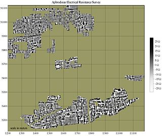
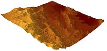
In archaeology, geophysical survey is ground-based physical sensing techniques used for archaeological imaging or mapping. Remote sensing and marine surveys are also used in archaeology, but are generally considered separate disciplines. Other terms, such as "geophysical prospection" and "archaeological geophysics" are generally synonymous.

<span class="mw-page-title-main">Landsat program</span> American network of Earth-observing satellites for international research purposes

The Landsat program is the longest-running enterprise for acquisition of satellite imagery of Earth. It is a joint NASA / USGS program. On 23 July 1972, the Earth Resources Technology Satellite was launched. This was eventually renamed to Landsat 1 in 1975. The most recent, Landsat 9, was launched on 27 September 2021.

<span class="mw-page-title-main">Photogrammetry</span> Taking measurements using photography

Photogrammetry is the science and technology of obtaining reliable information about physical objects and the environment through the process of recording, measuring and interpreting photographic images and patterns of electromagnetic radiant imagery and other phenomena.

Archaeological science consists of the application of scientific techniques to the analysis of archaeological materials and sites. It is related to methodologies of archaeology. Martinón-Torres and Killick distinguish ‘scientific archaeology’ from ‘archaeological science’. Martinón-Torres and Killick claim that ‘archaeological science’ has promoted the development of high-level theory in archaeology. However, Smith rejects both concepts of archaeological science because neither emphasize falsification or a search for causality.

<span class="mw-page-title-main">NASA WorldWind</span> Open-source virtual globe

NASA WorldWind is an open-source virtual globe. According to the website, "WorldWind is an open source virtual globe API. WorldWind allows developers to quickly and easily create interactive visualizations of 3D globe, map and geographical information. Organizations around the world use WorldWind to monitor weather patterns, visualize cities and terrain, track vehicle movement, analyze geospatial data and educate humanity about the Earth." It was first developed by NASA in 2003 for use on personal computers and then further developed in concert with the open source community since 2004. As of 2017, a web-based version of WorldWind is available online. An Android version is also available.

<span class="mw-page-title-main">Satellite imagery</span> Images taken from an artificial satellite

Satellite images are images of Earth collected by imaging satellites operated by governments and businesses around the world. Satellite imaging companies sell images by licensing them to governments and businesses such as Apple Maps and Google Maps.

<span class="mw-page-title-main">Survey (archaeology)</span> Non-destructive exploration of the archaeological material in a given area

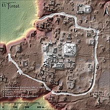
In archaeology, survey or field survey is a type of field research by which archaeologists search for archaeological sites and collect information about the location, distribution and organization of past human cultures across a large area. Archaeologists conduct surveys to search for particular archaeological sites or kinds of sites, to detect patterns in the distribution of material culture over regions, to make generalizations or test hypotheses about past cultures, and to assess the risks that development projects will have adverse impacts on archaeological heritage. The surveys may be: (a) intrusive or non-intrusive, depending on the needs of the survey team and; (b) extensive or intensive, depending on the types of research questions being asked of the landscape in question. Surveys can be a practical way to decide whether or not to carry out an excavation, but may also be ends in themselves, as they produce important information about past human activities in a regional context.

<span class="mw-page-title-main">Enclosure (archaeology)</span> Archaeological feature

In archaeology, an enclosure is one of the most common types of archaeological site – It is any area of land separated from surrounding land by earthworks, walls or fencing. Such a simple feature is found all over the world and during almost all archaeological periods. They may be few metres across or be large enough to encompass whole cities.

The year 1991 in archaeology involved some significant events.

In archaeology, seriation is a relative dating method in which assemblages or artifacts from numerous sites in the same culture are placed in chronological order. Where absolute dating methods, such as radio carbon, cannot be applied, archaeologists have to use relative dating methods to date archaeological finds and features. Seriation is a standard method of dating in archaeology. It can be used to date stone tools, pottery fragments, and other artifacts. In Europe, it has been used frequently to reconstruct the chronological sequence of graves in a cemetery.

<span class="mw-page-title-main">Wheeler–Kenyon method</span> Method of archaeological excavation

The Wheeler–Kenyon method is a method of archaeological excavation. The technique originates from the work of Mortimer Wheeler and Tessa Wheeler at Verulamium (1930–35), and was later refined by Kathleen Kenyon during her excavations at Jericho (1952–58). The Wheeler–Kenyon system involves digging within a series of squares that can vary in size set within a larger grid. This leaves a freestanding wall of earth—known as a "balk"—that can range from 50 cm for temporary grids, and measure up to 2 metres in width for a deeper square. The normal width of a permanent balk is 1 metre on each side of a unit. These vertical slices of earth allow archaeologists to compare the exact provenance of a found object or feature to adjacent layers of earth ("strata"). During Kenyon's excavations at Jericho, this technique helped discern the long and complicated occupational history of the site. It was believed that this approach allowed more precise stratigraphic observations than earlier "horizontal exposure" techniques that relied on architectural and ceramic analysis.

<span class="mw-page-title-main">Archaeology</span> Study of human activity via material culture

Archaeology or archeology is the study of human activity through the recovery and analysis of material culture. The archaeological record consists of artifacts, architecture, biofacts or ecofacts, sites, and cultural landscapes. Archaeology can be considered both a social science and a branch of the humanities. It is usually considered an independent academic discipline, but may also be classified as part of anthropology, history or geography.

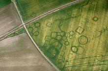
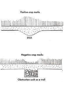
Remote sensing techniques in archaeology are an increasingly important component of the technical and methodological tool set available in archaeological research. The use of remote sensing techniques allows archaeologists to uncover unique data that is unobtainable using traditional archaeological excavation techniques.

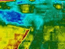
Multispectral remote sensing is the collection and analysis of reflected, emitted, or back-scattered energy from an object or an area of interest in multiple bands of regions of the electromagnetic spectrum. Subcategories of multispectral remote sensing include hyperspectral, in which hundreds of bands are collected and analyzed, and ultraspectral remote sensing where many hundreds of bands are used. The main purpose of multispectral imaging is the potential to classify the image using multispectral classification. This is a much faster method of image analysis than is possible by human interpretation.

WorldView-3 is a commercial Earth observation satellite owned by DigitalGlobe. It was launched on 13 August 2014 to become DigitalGlobe's sixth satellite in orbit, joining Ikonos which was launched in 1999, QuickBird in 2001, WorldView-1 in 2007, GeoEye-1 in 2008, and WorldView-2 in 2009. WorldView-3 provides commercially available panchromatic imagery of 0.31 m (12 in) resolution, eight-band multispectral imagery with 1.24 m resolution, shortwave infrared imagery at 3.7 m resolution, and CAVIS data at 30 m (98 ft) resolution.

This page is a glossary of archaeology, the study of the human past from material remains.

Digital archaeology is the application of information technology and digital media to archaeology. It includes the use of digital photography, 3D reconstruction, virtual reality, and geographical information systems, among other techniques. Computational archaeology, which covers computer-based analytical methods, can be considered a subfield of digital archaeology, as can virtual archaeology.

References

  1. 1 2 3 4 "Introduction to Aerial Archaeology". Aerial Archaeology Research Group. Retrieved 2022-05-13.
  2. Renfrew, C. and Bahn, P. (2016). Archaeology: Theories, Methods and Practice. High Holborn, London: Thames & Hudson Ltd. p. 80.{{cite book}}: CS1 maint: multiple names: authors list (link)
  3. Suguayani. "Multispectral image". Imagine Info. Retrieved 2022-05-13.
  4. Renfrew, C. and Bahn, P (2016). Archaeology: Theories, Methods and Practice. High Holborn, London: Thames & Hudson Ltd. p. 81.{{cite book}}: CS1 maint: multiple names: authors list (link)
  5. Renfrew, C. and Bahn, P. (2016). Archaeology: Theories, Methods and Practice. High Holborn, London: Thames & Hudson Ltd. p. 84.{{cite book}}: CS1 maint: multiple names: authors list (link)
  6. 1 2 3 4 5 6 7 Renfrew, C. and Bahn, P. (2016). Archaeology: Theories, Methods and Practice. High Holborn, London: Thames & Hudson Ltd.
  7. 1 2 3 4 Cowley, Dave (2012). Interpreting Archaeological Topography : Lasers, 3d Data, Observation, Visualisation and Applications. Oxbow Books Ltd. OCLC   815945744.
  8. Brophy, K. and Cowley, D. (2005). From the air: Understanding aerial archaeology. Stroud, Gloucestershire: Tempus publishing limited.
  9. Brophy, K. and Cowley, D. (2005). From the air: Understanding aerial archaeology. Stroud, Gloucestershire: Tempus publishing limited. p. 14.{{cite book}}: CS1 maint: multiple names: authors list (link)
  10. Brophy, K. and Cowley, D. (2005). From the air: Understanding aerial archaeology. Stroud, Gloucestershire: Tempus publishing limited. p.13
  11. 1 2 Deuel, Leo (1973). Flights into Yesterday : the story of aerial archaeology. Penguin Books. ISBN   0-14-021626-X. OCLC   963497702.
  12. 1 2 3 Renfrew, C. and Bahn, P. (2016). Archaeology: Theories, Methods and Practice. High Holborn, London: Thames & Hudson Ltd. p.85
  13. Renfrew, C. and Bahn, P. (2016). Archaeology: Theories, Methods and Practice. High Holborn, London: Thames & Hudson Ltd. p.90
  14. 1 2 3 4 5 6 7 Parcak, Sarah H. (2009). Satellite Remote Sensing for Archaeology. Routledge. ISBN   978-0-415-44878-9. OCLC   1291927464.
  15. 1 2 Renfrew, C. and Bahn, P. (2016). Archaeology: Theories, Methods and Practice. High Holborn, London: Thames & Hudson Ltd. p.92
  16. Renfrew, C. and Bahn, P. (2016). Archaeology: Theories, Methods and Practice. High Holborn, London: Thames & Hudson Ltd. p.89
Bibliography