In archaeology, excavation is the exposure, processing and recording of archaeological remains. An excavation site or "dig" is the area being studied. These locations range from one to several areas at a time during a project and can be conducted over a few weeks to several years.

Kite aerial photography (KAP) is a type of photography. A camera is lifted using a kite and is triggered either remotely or automatically to take aerial photographs. The camera rigs can range from the extremely simple, consisting of a trigger mechanism with a disposable camera, to complex apparatus using radio control and digital cameras. On some occasions it can be a good alternative to other forms of aerial photography.
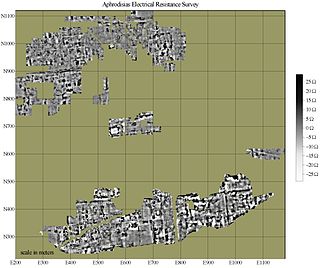
In archaeology, geophysical survey is ground-based physical sensing techniques used for archaeological imaging or mapping. Remote sensing and marine surveys are also used in archaeology, but are generally considered separate disciplines. Other terms, such as "geophysical prospection" and "archaeological geophysics" are generally synonymous.
Aerial archaeology is the study of archaeological remains by examining them from a higher altitude. In present day, this is usually achieved by satellite images or through the use of drones.

The Goseck Circle is a Neolithic structure in Goseck in the Burgenlandkreis district in Saxony-Anhalt, Germany.

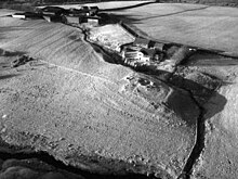
Cropmarks or crop marks are a means through which sub-surface archaeological, natural and recent features may be visible from the air or a vantage point on higher ground or a temporary platform. Such marks, along with parch marks, soil marks and frost marks, can reveal buried archaeological sites that are not visible from the ground.
Cursuses are monumental Neolithic structures resembling ditches or trenches in the islands of Great Britain and Ireland. Relics found within them indicate that they were built between 3400 and 3000 BC, making them among the oldest monumental structures on the islands. The name 'cursus' was suggested in 1723 by William Stukeley, the antiquarian, who compared the Stonehenge cursus to a Roman chariot-racing track, or circus.
Little Woodbury is the name of an Iron Age archaeological site in Britford parish, near Salisbury in the English county of Wiltshire.

In archaeology, survey or field survey is a type of field research by which archaeologists search for archaeological sites and collect information about the location, distribution and organization of past human cultures across a large area. Archaeologists conduct surveys to search for particular archaeological sites or kinds of sites, to detect patterns in the distribution of material culture over regions, to make generalizations or test hypotheses about past cultures, and to assess the risks that development projects will have adverse impacts on archaeological heritage. The surveys may be: (a) intrusive or non-intrusive, depending on the needs of the survey team and; (b) extensive or intensive, depending on the types of research questions being asked of the landscape in question. Surveys can be a practical way to decide whether or not to carry out an excavation, but may also be ends in themselves, as they produce important information about past human activities in a regional context.
In archaeology, a ring ditch is a trench of circular or penannular plan, cut into bedrock. They are usually identified through aerial photography either as soil marks or cropmarks. When excavated, ring ditches are usually found to be the ploughed‐out remains of a round barrow where the barrow mound has completely disappeared, leaving only the infilled former quarry ditch. Both Neolithic and Bronze Age ring ditches have been discovered.
As with most academic disciplines, there are a number of archaeological sub-disciplines typically characterised by a focus on a specific method or type of material, geographical or chronological focus, or other thematic concern.
Battlefield archaeology is a sub-discipline of archaeology which studies the material remains and topography of a battlefield to understand a conflict. Archaeological battlefields consist of skirmishes, sieges, camps, and training sites. The study of the relationships and contexts of the material by-products of war give an alternate account to the version recorded in a history book, poem, or witness account, which may be constructed though bias, or may present only a limited perspective of the events. Examination of these locations gives insight to what tactics were being used, weapon modifications, and battle formations. It is not considered distinct from Military archaeology or Recceology.

In archaeology, earthworks are artificial changes in land level, typically made from piles of artificially placed or sculpted rocks and soil. Earthworks can themselves be archaeological features, or they can show features beneath the surface.
Balbridie is the site of a Neolithic long house in Aberdeenshire, Scotland, situated on the south bank of the River Dee, east of Banchory. The site is one of the earliest known permanent Neolithic settlements in Scotland, dating from 3400 to 4000 BC. This is the largest Neolithic long house to be excavated in Britain. In a European context, Whittle has indicated the rarity of such large Neolithic timber houses, citing Balbridie, a hall in Cambridgeshire, and Fengate as a small set of such finds.
Wilbury Hill Camp is a late Bronze Age hill fort west of Letchworth in Hertfordshire. It and Arbury Banks near Ashwell are two of a line of six similar hill forts along the northern Chilterns. It is a scheduled ancient monument. The site is marked by two circular defences formed by single banks and external ditches. Although these are no longer conspicuous on the ground, distinct cropmarks generated by the buried features have been recorded by aerial photography since the 1950s.

Aerial photographic and satellite image interpretation, or just image interpretation when in context, is the act of examining photographic images, particularly airborne and spaceborne, for the purpose of identifying objects and judging their significance. This is commonly used in military aerial reconnaissance, using photographs taken from reconnaissance aircraft and reconnaissance satellites.

Archaeology or archeology is the scientific study of human activity through the recovery and analysis of material culture. The archaeological record consists of artifacts, architecture, biofacts or ecofacts, sites, and cultural landscapes. Archaeology can be considered both a social science and a branch of the humanities. It is usually considered an independent academic discipline, but may also be classified as part of anthropology, history or geography.
Digital archaeology is the application of information technology and digital media to archaeology. It includes the use of digital photography, 3D reconstruction, virtual reality, and geographical information systems, among other techniques. Computational archaeology, which covers computer-based analytical methods, can be considered a subfield of digital archaeology, as can virtual archaeology.
Brandon Camp is an archaeological site, about 1 mile south of Leintwardine, in Herefordshire. England. It is a hillfort of the Iron Age, which later became a Roman fort. The site is a scheduled monument.

Aerial photograph interpretation is a method of extrapolating geological details of the ground surface from aerial images. It allows geologists to analyze the distinguishing geological features and structures, plant cover, past history of the site, soil properties, and topography of the study area. It is crucial in the early stage of a geological mapping as it is less time-consuming and offers important data at a minimal price. It is also commonly used in other industries, such as forest management, environmental science, disciplines of engineering, aviation accidents.