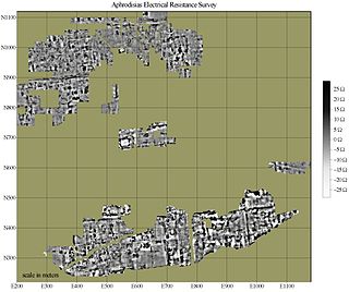
Electrical resistance surveys (also called earth resistance or resistivity survey) are one of a number of methods used in archaeological geophysics, as well as in engineering geological investigations. In this type of survey electrical resistance meters are used to detect and map subsurface archaeological features and patterning.
Electrical resistance meters can be thought of as similar to the Ohmmeters used to test electrical circuits. Archaeological features can be mapped when they are of higher or lower resistivity than their surroundings. A stone foundation might impede the flow of electricity, while the organic deposits within a midden might conduct electricity more easily than surrounding soils. Although generally used in archaeology for planview mapping, resistance methods also have a limited ability to discriminate depth and create vertical profiles (see Electrical resistivity tomography). Further applications include the measurement of the electrical resistivity of concrete to determinate the corrosion potential in concrete structures. Electrical resistance surveying is one of the most popular geophysical methods thanks to the fact it is a nondestructive and economically favorable investigation.[1]
Instrumentation
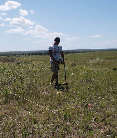
Electrical resistance survey of an archaeological site using a twin probe system
In most systems, metal probes (electrodes) are inserted into the ground to obtain a reading of the local electrical resistance. A variety of probe configurations are used, most having four probes, often mounted on a rigid frame. In these systems, two of the probes, called current probes, are used to introduce a current (either direct or low-frequency switching current) into the earth. The other two probes, called voltage or potential probes, are used to measure the voltage, which indicates the local resistivity. In general, greater probe spacings yield greater depth of investigation, but at the cost of sensitivity and spatial resolution.[2]
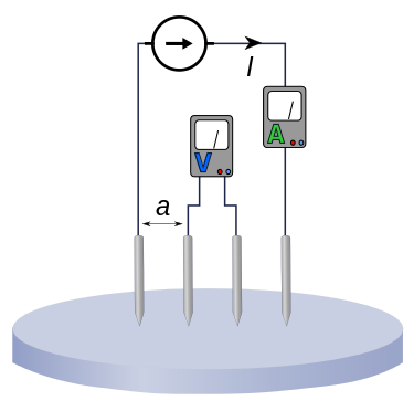
Arrangement of probes in a Wenner electrode array.
Early surveys (beginning in the mid 20th century) often used the Wenner array, which was a linear array of four probes. These were arranged current-voltage-voltage-current, at equal distances across the array. Probes were mounted on a rigid frame, or placed individually. While quite sensitive, this array has a very wide span for its depth of investigation, leading to problems with horizontal resolution. A number of experimental arrays attempted to overcome the shortcomings of the Wenner array, the most successful of these being the twin-probe array, which has become the standard for archaeological use. The twin-probe array - despite its name - has four probes: one current and one voltage probe mounted on a mobile frame to collect survey readings, and the other current probe placed remotely along with a voltage reference probe. These fixed remote probes are connected to the mobile survey probes by a trailing cable. This configuration is very compact for its depth of investigation, resulting in superior horizontal resolution.[3] The logistical advantage of the more compact array is somewhat offset by the trailing cable.
A disadvantage of the systems described above is a relatively slow rate of survey. One solution to this has been wheeled arrays. These use spiked wheels or metal disks as electrodes, and may use a square array (a variation of the Wenner array) to avoid the encumbrance of a trailing cable. Wheeled arrays may be towed by vehicles or by human power.[4]
Systems having long linear arrays of many electrodes are often used in geological applications, and less commonly in archaeology. These take repeated measurements (often computer controlled) using different electrode spacings at multiple points along the extended line of electrodes.[5] Data collected in this way may be used for tomography, or generating vertical profiles.[6]
Capacitively coupled systems that do not require direct physical contact with the soil have also been developed. These systems are capable of tomographic studies as well as mapping horizontal patterning. They may also be used on hard or very dry surfaces that preclude electrical contact necessary for probe resistance systems. While these show promise for archaeological applications, currently available systems operating on this principle lack sufficient spatial resolution and sensitivity. [7][8]
Data collection
Survey usually involves walking with the instrument along closely spaced parallel traverses, taking readings at regular intervals. In most cases, the area to be surveyed is staked into a series of square or rectangular survey "grids" (terminology can vary). With the corners of the grids as known reference points, the instrument operator uses tapes or marked ropes as a guide when collecting data. In this way, positioning error can be kept to within a few centimeters for high-resolution mapping. Early surveys recorded readings by hand, but computer controlled data logging and storage are now the norm.[9]
In archaeology, geophysical survey is ground-based physical sensing techniques used for archaeological imaging or mapping. Remote sensing and marine surveys are also used in archaeology, but are generally considered separate disciplines. Other terms, such as "geophysical prospection" and "archaeological geophysics" are generally synonymous.
A telluric current, or Earth current, is an electric current which moves underground or through the sea. Telluric currents result from both natural causes and human activity, and the discrete currents interact in a complex pattern. The currents are extremely low frequency and travel over large areas at or near the surface of the Earth.
An Earth battery is a pair of electrodes made of two dissimilar metals, such as iron and copper, which are buried in the soil or immersed in the sea. Earth batteries act as water activated batteries and if the plates are sufficiently far apart, they can tap telluric currents. Earth batteries are sometimes referred to as telluric power sources and telluric generators.
Ground-penetrating radar (GPR) is a geophysical method that uses radar pulses to image the subsurface. It is a non-intrusive method of surveying the sub-surface to investigate underground utilities such as concrete, asphalt, metals, pipes, cables or masonry. This nondestructive method uses electromagnetic radiation in the microwave band of the radio spectrum, and detects the reflected signals from subsurface structures. GPR can have applications in a variety of media, including rock, soil, ice, fresh water, pavements and structures. In the right conditions, practitioners can use GPR to detect subsurface objects, changes in material properties, and voids and cracks.
Exploration geophysics is an applied branch of geophysics and economic geology, which uses physical methods, such as seismic, gravitational, magnetic, electrical and electromagnetic at the surface of the Earth to measure the physical properties of the subsurface, along with the anomalies in those properties. It is most often used to detect or infer the presence and position of economically useful geological deposits, such as ore minerals; fossil fuels and other hydrocarbons; geothermal reservoirs; and groundwater reservoirs.
Magnetotellurics (MT) is an electromagnetic geophysical method for inferring the earth's subsurface electrical conductivity from measurements of natural geomagnetic and geoelectric field variation at the Earth's surface.
In neuroscience, single-unit recordings provide a method of measuring the electro-physiological responses of a single neuron using a microelectrode system. When a neuron generates an action potential, the signal propagates down the neuron as a current which flows in and out of the cell through excitable membrane regions in the soma and axon. A microelectrode is inserted into the brain, where it can record the rate of change in voltage with respect to time. These microelectrodes must be fine-tipped, low-impedance conductors; they are primarily glass micro-pipettes, metal microelectrodes made of platinum, tungsten, iridium or even iridium oxide. Microelectrodes can be carefully placed close to the cell membrane, allowing the ability to record extracellularly.
Electrical resistivity tomography (ERT) or electrical resistivity imaging (ERI) is a geophysical technique for imaging sub-surface structures from electrical resistivity measurements made at the surface, or by electrodes in one or more boreholes. If the electrodes are suspended in the boreholes, deeper sections can be investigated. It is closely related to the medical imaging technique electrical impedance tomography (EIT), and mathematically is the same inverse problem. In contrast to medical EIT, however, ERT is essentially a direct current method. A related geophysical method, induced polarization, measures the transient response and aims to determine the subsurface chargeability properties.
Four-terminal sensing, 4-wire sensing, or 4-point probes method is an electrical impedance measuring technique that uses separate pairs of current-carrying and voltage-sensing electrodes to make more accurate measurements than the simpler and more usual two-terminal (2T) sensing. Four-terminal sensing is used in some ohmmeters and impedance analyzers, and in wiring for strain gauges and resistance thermometers. Four-point probes are also used to measure sheet resistance of thin films.
The term contact resistance refers to the contribution to the total resistance of a system which can be attributed to the contacting interfaces of electrical leads and connections as opposed to the intrinsic resistance. This effect is described by the term electrical contact resistance (ECR) and arises as the result of the limited areas of true contact at an interface and the presence of resistive surface films or oxide layers. ECR may vary with time, most often decreasing, in a process known as resistance creep. The idea of potential drop on the injection electrode was introduced by William Shockley to explain the difference between the experimental results and the model of gradual channel approximation. In addition to the term ECR, interface resistance, transitional resistance, or just simply correction term are also used. The term parasitic resistance is used as a more general term, of which it is usually assumed that contact resistance is a major component.
Induced polarization (IP) is a geophysical imaging technique used to identify the electrical chargeability of subsurface materials, such as ore.
An electrode array is a configuration of electrodes used for measuring either an electric current or voltage. Some electrode arrays can operate in a bidirectional fashion, in that they can also be used to provide a stimulating pattern of electric current or voltage.
Magnetic surveying is one of a number of methods used in archaeological geophysics. Magnetic surveys record spatial variation in the Earth's magnetic field. In archaeology, magnetic surveys are used to detect and map archaeological artefacts and features. Magnetic surveys are used in both terrestrial and marine archaeology.
Electro Thermal Dynamic Stripping Process (ET-DSP) is a patented in situ thermal environmental remediation technology, created by McMillan-McGee Corporation, for cleaning contaminated sites. ET-DSP uses readily available three phase electric power to heat the subsurface with electrodes. Electrodes are placed at various depths and locations in the formation. Electric current to each electrode is controlled continuously by computer to uniformly heat the target contamination zone.
Concrete electrical resistivity can be obtained by applying a current into the concrete and measuring the response voltage. There are different methods for measuring concrete resistivity.
Near-surface geophysics is the use of geophysical methods to investigate small-scale features in the shallow subsurface. It is closely related to applied geophysics or exploration geophysics. Methods used include seismic refraction and reflection, gravity, magnetic, electric, and electromagnetic methods. Many of these methods were developed for oil and mineral exploration but are now used for a great variety of applications, including archaeology, environmental science, forensic science, military intelligence, geotechnical investigation, treasure hunting, and hydrogeology. In addition to the practical applications, near-surface geophysics includes the study of biogeochemical cycles.
Soil resistivity is a measure of how much the soil resists or conducts electric current. It is a critical factor in design of systems that rely on passing current through the Earth's surface. An understanding of the soil resistivity and how it varies with depth in the soil is necessary to design the grounding system in an electrical substation, or for lightning conductors. It is needed for design of grounding (earthing) electrodes for substations and High-voltage direct current transmission systems. It was formerly important in earth-return telegraphy. It can also be a useful measure in agriculture as a proxy measurement for moisture content.
Forensic geophysics is a branch of forensic science and is the study, the search, the localization and the mapping of buried objects or elements beneath the soil or the water, using geophysics tools for legal purposes. There are various geophysical techniques for forensic investigations in which the targets are buried and have different dimensions. Geophysical methods have the potential to aid the search and the recovery of these targets because they can non-destructively and rapidly investigate large areas where a suspect, illegal burial or, in general, a forensic target is hidden in the subsoil. When in the subsurface there is a contrast of physical properties between a target and the material in which it is buried, it is possible to individuate and define precisely the concealing place of the searched target. It is also possible to recognize evidences of human soil occupation or excavation, both recent and older. Forensic geophysics is an evolving technique that is gaining popularity and prestige in law enforcement.
Teledeltos paper is an electrically conductive paper. It is formed by a coating of carbon on one side of a sheet of paper, giving one black and one white side. Western Union developed Teledeltos paper in the late 1940s for use in spark printer based fax machines and chart recorders.
Vertical electrical sounding (VES) is a geophysical method for investigation of a geological medium. The method is based on the estimation of the electrical conductivity or resistivity of the medium. The estimation is performed based on the measurement of voltage of electrical field induced by the distant grounded electrodes.
This page is based on this Wikipedia article Text is available under the CC BY-SA 4.0 license; additional terms may apply. Images, videos and audio are available under their respective licenses.