
The geologic time scale (GTS) is a system of chronological dating that classifies geological strata (stratigraphy) in time. It is used by geologists, paleontologists, and other Earth scientists to describe the timing and relationships of events in geologic history. The time scale was developed through the study and observation of layers of rock and relationships as well as the times when different organisms appeared, evolved and became extinct through the study of fossilized remains and imprints. The table of geologic time spans, presented here, agrees with the nomenclature, dates and standard color codes set forth by the International Commission on Stratigraphy (ICS).

In archaeology, excavation is the exposure, processing and recording of archaeological remains. An excavation site or "dig" is the area being studied. These locations range from one to several areas at a time during a project and can be conducted over a few weeks to several years.

Stratigraphy is a branch of geology concerned with the study of rock layers (strata) and layering (stratification). It is primarily used in the study of sedimentary and layered volcanic rocks. Stratigraphy has two related subfields: lithostratigraphy and biostratigraphy.

Aetokremnos is a rock shelter near Limassol on the southern coast of Cyprus. It is situated on a steep cliff site c. 40 m (131.23 ft) above the Mediterranean sea. The name means "Cliff of the eagles" in Greek. Around 40 m2 (430.56 sq ft) have been excavated and out of the four layers documented, the third is sterile.

Endurance is an impact crater lying situated within the Margaritifer Sinus quadrangle (MC-19) region of the planet Mars. This crater was visited by the Opportunity rover from May until December 2004. Mission scientists named the crater after the ship Endurance that sailed to the Antarctic through the Weddell Sea during the ill-fated 1914-1917 Imperial Trans-Antarctic Expedition, considered to be the last expedition of the Heroic Age of Antarctic Exploration organized by Ernest Shackleton.

Biostratigraphy is the branch of stratigraphy which focuses on correlating and assigning relative ages of rock strata by using the fossil assemblages contained within them. The primary objective of biostratigraphy is correlation, demonstrating that a particular horizon in one geological section represents the same period of time as another horizon at a different section. Fossils within these strata are useful because sediments of the same age can look completely different, due to local variations in the sedimentary environment. For example, one section might have been made up of clays and marls, while another has more chalky limestones. However, if the fossil species recorded are similar, the two sediments are likely to have been laid down around the same time. Ideally these fossil are used to help identify biozones, as they make up the basic biostratigraphy units, and define geological time periods based upon the fossil species found within each section.

Zhoukoudian Peking Man Site (周口店北京人遗址), also romanized as Choukoutien, is a cave system in suburban Fangshan District, Beijing. It has yielded many archaeological discoveries, including one of the first specimens of Homo erectus, dubbed Peking Man, and a fine assemblage of bones of the gigantic hyena Pachycrocuta brevirostris.

Stratigraphy is a key concept to modern archaeological theory and practice. Modern excavation techniques are based on stratigraphic principles. The concept derives from the geological use of the idea that sedimentation takes place according to uniform principles. When archaeological finds are below the surface of the ground, the identification of the context of each find is vital in enabling the archaeologist to draw conclusions about the site and about the nature and date of its occupation. It is the archaeologist's role to attempt to discover what contexts exist and how they came to be created. Archaeological stratification or sequence is the dynamic superimposition of single units of stratigraphy, or contexts.

The Harris matrix is a tool used to depict the temporal succession of archaeological contexts and thus the sequence of depositions and surfaces on a 'dry land' archaeological site, otherwise called a 'stratigraphic sequence'. The matrix reflects the relative position and stratigraphic contacts of observable stratigraphic units, or contexts. The Matrix was developed in 1973 in Winchester, England, by Dr. Edward C. Harris.
In the stratigraphy sub-discipline of geology, a Global Standard Stratigraphic Age, abbreviated GSSA, is a chronological reference point and criterion in the geologic record used to define the boundaries between different geological periods, epochs or ages on the overall geologic time scale in a chronostratigraphically useful rock layer. A worldwide multidisciplinary effort has been ongoing since 1974 to define such important metrics. The points and strata need be widespread and contain an identifiable sequence of layers or other unambiguous marker attributes.

Beds are the layers of sedimentary rocks that are distinctly different from overlying and underlying subsequent beds of different sedimentary rocks. Layers of beds are called strata. They are formed from sediments being deposited on the Earth's solid surface over long periods of time. The strata are layered in the same order that they were deposited, permitting discrimination as to which beds are younger and which ones are older. The structure of a bed is determined by its bedding plane, the surface that separates two layers. Beds can be differentiated in various ways, such as by particle size or rock or mineral type. The term is generally applied to sedimentary strata, but may also be used for volcanic flows or ash layers.

Ventana Cave is an archaeological site in southern Arizona. It is located on the Tohono O'odham Indian Reservation. The cave was excavated under the direction of Emil Haury by teams led by Julian Hayden in 1942, and in 1941 by a team led by Wilfrid C Bailey, one of Emil Haury's graduate students. The deepest artifacts from Ventana Cave were recovered from a layer of volcanic debris that also contained Pleistocene horse, Burden's pronghorn, tapir, sloth, and other extinct and modern species. A projectile point from the volcanic debris layer was compared to the Folsom Tradition and later to the Clovis culture, but the assemblage was peculiar enough to warrant a separate name – the Ventana Complex. Radiocarbon dates from the volcanic debris layer indicated an age of about 11,300 BP.

Azykh Cave, also referred to as Azokh Cave is a six-cave complex in Azerbaijan, known as a habitation site of prehistoric humans.
A system in stratigraphy is a unit of rock layers that were laid down together within the same corresponding geological period. The associated period is a chronological time unit, a part of the geological time scale, while the system is a unit of chronostratigraphy. Systems are unrelated to lithostratigraphy, which subdivides rock layers on their lithology. Systems are subdivisions of erathems and are themselves divided into series and stages.
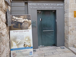
The Burnt House Museum is a museum presenting an excavated house from the Second Temple period situated six metres below current street level in the Jewish Quarter of the Old City of Jerusalem.

The Con Moong cave is located in the Cúc Phương National Park, just south of Mọ village, in the Thanh Hóa Province, northern Vietnam. The Department of Culture has issued a certificate that declares Con Moong prehistoric site and its surroundings as National Relics and is managed by the Cúc Phương National Park administration, along with a refuge for rare animals. Among these locations, the archaeological site of Con Moong cave is of central importance for the study of the Mesolithic Hoabinhian culture. In April and May 1976, Vietnamese archaeologists excavated the site.

Mummy Cave is a rock shelter and archeological site in Park County, Wyoming, United States, near the eastern entrance to Yellowstone National Park. The site is adjacent to the concurrent U.S. Routes 14/16/20, on the left bank of the North Fork of the Shoshone River at an altitude of 6,310 feet (1,920 m) in Shoshone National Forest.

Taghlar cave is an archaeological site that was inhabited by prehistoric humans of the Mousterian culture during the Paleolithic. The cave is located in Azerbaijan, in the southern part of Boyuk Taghlar village, on the left banks of the Guruchay River.

Ifri Oudadane is an archaeological site in the northeastern Rif region of Morocco. It is located on the southwestern coast of the Cape Three Forks on the Mediterranean Sea, and is one of the most important sites in the northwestern Maghreb region of Africa. Discovered during road construction, the site consists of a fairly large rock shelter above the modern coastline, the site has been excavated since 2006 by a team of Moroccan and German archaeologists. Although much is known about the transition of humans from hunter gatherer groups to food production in Europe and the Middle East, much of North Africa has not been researched. Ifri Oudadane is one of the first of such sites in North Africa. Dated to between 11000 and 5700 years BP, the site contains evidence that documents the shift of local inhabitants from hunter-gatherer groups to food producers. Such elements of change found at Ifri Oudadane include evidence of animal husbandry, domestication of legumes, and decoration of pottery. The site is known to contain the earliest dated crop in Northern Africa, a lentil.
Romuald’s Cave is a cave in the western part of Istria County, Croatia, that contains the oldest known cave paintings in southeast Europe, as well as traces of both animal and human Upper Paleolithic habitation. Although the cave has been excavated since late 19th century, the paintings were only found in 2010, by Professor Darko Komšo, while the findings were published in Antiquity in 2019.
