Arcadia, New York

Last updated
Arcadia, New York
Wayne County New York incorporated and unincorporated areas Arcadia highlighted.svg
Location in Wayne County and the state of New York.
USA New York location map.svg
Red pog.svg
Arcadia, New York
Coordinates: 43°3′42″N77°5′16″W / 43.06167°N 77.08778°W / 43.06167; -77.08778
Country United States
State New York
County Wayne
Settled1791
EstablishedFebruary 15, 1825 [1]
Government
  Type Town Board
   Supervisor Jon "Chuck" Verkey
  Council Members:Richard VanLaeken
David Greco
Michael Diamond
Dawn Pisciotti
   Clerk Diane Allerton
   Court Justice Arthur B. Williams
Justice Michael R. Miller
   Historian Christopher Davis [2]
Area
[3]
  Total52.14 sq mi (135.05 km2)
  Land52.03 sq mi (134.76 km2)
  Water0.11 sq mi (0.29 km2)
Elevation
443 ft (135 m)
Population
 (2010)
  Total14,244
  Estimate 
(2016) [4]
13,686
  Density263.03/sq mi (101.56/km2)
Time zone UTC-5 (Eastern (EST))
  Summer (DST) UTC-4 (EDT)
Area codes 315 and 680
FIPS code 36-02440
GNIS feature ID0978686
Website https://townarcadia.digitaltowpath.org/

Arcadia is a town in Wayne County, New York, United States. The population was 14,244 at the 2010 census.

Contents

The Town of Arcadia is on the south border of the county and is east of Rochester, New York.

The primary postal district covering the Town of Arcadia is ZIP Code 14513 for Newark. [5]

History

The town was first settled circa 1791.

The Town of Arcadia was formed from the Town of Lyons in 1825.

An asylum for the mentally disabled was established in Arcadia in 1789.

Hydesville, New York was a hamlet in the Town of Arcadia. It no longer exists, but was the hometown of the spiritualist Fox Sisters. [6] [7]

In 1957, the Bergen Swamp Preservation Society acquired Zurich Bog for conservation.

The town is part of the Erie Canalway National Heritage Corridor. [8]

Geography

According to the United States Census Bureau, the town has a total area of 52.1 square miles (135 km2), of which 52.0 square miles (135 km2) is land and 0.1 square miles (0.26 km2) (0.19%) is water.

The Erie Canal passes across the town and through the Village of Newark. The east end of "the Wide Waters," a wide part of the canal, is in the town.

The terrain contains many drumlins from past glaciation as well as the Zurich Bog.

The southern town line is the border of Ontario County.

New York State Route 31 (east-west) intersects New York State Route 88 in Newark, just south of the Erie Canal.

Demographics

Historical population
CensusPop.Note
1830 3,774
1840 4,98032.0%
1850 5,1453.3%
1860 5,3193.4%
1870 5,271−0.9%
1880 5,7028.2%
1890 6,31010.7%
1900 7,04611.7%
1910 8,67223.1%
1920 9,2666.8%
1930 10,0518.5%
1940 12,10820.5%
1950 12,8165.8%
1960 15,83623.6%
1970 15,245−3.7%
1980 14,697−3.6%
1990 14,8551.1%
2000 14,8890.2%
2010 14,244−4.3%
2016 (est.)13,686 [4] −3.9%
U.S. Decennial Census [9]

As of the census [10] of 2010, there were 14,244 people, 5,792 households, and 3,632 families residing in the town. The population density was 273.4 inhabitants per square mile (105.6/km2). The racial makeup of the town was 89.3% White, 4.6% Black or African American, 0.3% Native American, 0.5% Asian, 0.1% Pacific Islander, 2.2% from other races, and 2.9% from two or more races. Hispanic or Latino of any race were 6.8% of the population.

There were 5,792 households, out of which 26.6% had children under the age of 18 living with them, 43.2% were married couples living together, 14.4% had a female householder with no husband present, and 37.3% were non-families. 30.6% of all households were made up of individuals, and 11.9% had someone living alone who was 65 years of age or older. The average household size was 2.38 and the average family size was 2.93.

In the town, the population was spread out, with 24.8% under the age of 20, 5.9% from 20 to 24, 22.7% from 25 to 44, 30.3% from 45 to 64, and 16.4% who were 65 years of age or older. The median age was 42.4 years. For every 100 females, there were 93.6 males. For every 100 females age 18 and over, there were 91.2 males.

The median income for a household in the town was $44,993, and the median income for a family was $54,415. Males had a median income of $38,636 versus $33,172 for females. The per capita income for the town was $22,331. About 12.2% of families and 15.0% of the population were below the poverty line, including 22.3% of those under age 18 and 10.8% of those age 65 or over.

Housing

There were 6,194 housing units at an average density of 118.9 per square mile (45.9/km2). 6.5% of housing units were vacant.

There were 5,792 occupied housing units in the town. 3,798 were owner-occupied units (65.6%), while 1,994 were renter-occupied (34.4%). The homeowner vacancy rate was 1.8% of total units. The rental unit vacancy rate was 6.3%. [10]

Communities and locations in the Town of Arcadia

Notable people

See also

Related Research Articles

<span class="mw-page-title-main">Wayne County, New York</span> County in New York, United States

Wayne County is a county in the U.S. state of New York. As of the 2020 Census, the population was 91,283. The county seat is Lyons. The name honors General Anthony Wayne, an American Revolutionary War hero and American statesman.

Ashford is a town in Cattaraugus County, New York, United States. The population was 1,974 at the 2020 census. The town is on the county's northern border.

<span class="mw-page-title-main">Royalton, New York</span> Town in New York, United States

Royalton is a town in Niagara County, New York, United States. The population was 7,660 at the 2010 census.

<span class="mw-page-title-main">Verona, New York</span> Town in New York, United States

Verona is a town in southwestern Oneida County, New York, United States. The population was 6,293 at the 2010 census. The town was named after Verona, Italy.

<span class="mw-page-title-main">Vienna, New York</span> Town in New York, United States

Vienna is a town in Oneida County, New York, United States. The population was 5,440 at the 2010 census. The town is named after the capital of Austria.

<span class="mw-page-title-main">Cicero, New York</span> Town in New York, United States

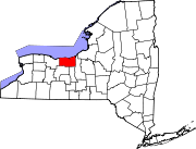
Cicero is a town in northern Onondaga County, New York, United States. As of the 2020 Census, the population was 31,435. The name of the town was assigned by a clerk interested in the classics, honoring Cicero, a Roman statesman.

<span class="mw-page-title-main">Boylston, New York</span> Town in New York, United States

Boylston is a town in Oswego County, New York, United States. The population was 549 at the 2010 census. The name is that of the first landowner of the tract that became the town.

<span class="mw-page-title-main">Schroeppel, New York</span> Town in New York, United States

Schroeppel is a town in Oswego County, New York, United States. The population was 8,501 at the 2010 census. The name derives from the Schroeppel family, early land owners of the area. Schroeppel is located in the southeast part of the county.

<span class="mw-page-title-main">Carlisle, New York</span> Town in New York, United States

Carlisle is a town in northern Schoharie County, New York, United States. The population was 1,758 at the 2000 census.

<span class="mw-page-title-main">Tyre, New York</span> Town in New York, United States

Tyre is a town in Seneca County, New York, United States. The population was 1,002 at the 2020 census. The town is named after the Lebanese city of Tyre.

<span class="mw-page-title-main">Marbletown, New York</span> Town in New York, United States

Marbletown is a town in Ulster County, New York, United States. The population was 5,658 at the 2020 census. It is located near the center of Ulster County, southwest of the City of Kingston. US 209 and NY 213 pass through the town. It is at the eastern edge of the Catskill Park.

<span class="mw-page-title-main">Olive, New York</span> Town in New York, United States

Olive is a town in Ulster County, New York, United States. The town is west of Kingston, New York and is inside the Catskill Park. The population was 4.226 at the 2020 census.

<span class="mw-page-title-main">Galen, New York</span> Town in New York, United States

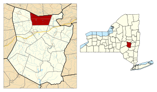
Galen is a town in Wayne County, New York, United States. The population was 4,290 at the 2010 census. The town is named after the classical physician Galen.

<span class="mw-page-title-main">Newark, New York</span> Village in New York, United States

Newark is a village in Wayne County, New York, United States, 35 miles (56 km) south east of Rochester and 48 miles (77 km) west of Syracuse. The population was 9,017 at the 2020 census. The Village of Newark is in the south part of the Town of Arcadia and is in the south of Wayne County. It is the most populous community in Wayne County.

<span class="mw-page-title-main">Ripley, New York</span> Town in New York, United States

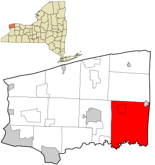
Ripley is a town on Lake Erie in the westernmost part of Chautauqua County, New York, United States. The population was 2,310 at the time of the 2020 census. The town was named after Eleazer Wheelock Ripley, a general in the War of 1812. There are no incorporated villages in the town, but there is one census-designated place: the hamlet of Ripley. The town is perhaps best known as being the western end of the New York State Thruway.

<span class="mw-page-title-main">Macedon, New York</span> Town in New York, United States

Macedon is a town in Wayne County, New York, United States. The population was 9,148 at the 2010 census.

<span class="mw-page-title-main">Palmyra (village), New York</span> Village in New York, United States

Palmyra is a village in Wayne County, New York, United States. The population was 3,536 at the 2010 census. The village, along with the town, is named after Palmyra in present-day Syria.

<span class="mw-page-title-main">Palmyra (town), New York</span> Town in New York, United States

Palmyra is a town in southwestern Wayne County, New York, United States. The population was 7,975 at the 2010 census. The town is named after the ancient city Palmyra in Syria.

<span class="mw-page-title-main">Lyons, New York</span> Town in New York, United States

Lyons is a town in Wayne County, New York, United States. The population was 5,682 at the 2010 census. It is named after Lyon, France.

<span class="mw-page-title-main">Ganargua Creek</span> River in New York, United States

Ganargua Creek, also known as Mud Creek, is a main tributary which feeds the Erie Canal and Clyde River in Wayne County, New York, United States. The creek begins just east of the village of Victor in nearby Ontario County and meanders approximately 34 miles from west to east before emptying into the Erie Canal in the hamlet of Lyons. Ganargua Creek is actually split into two sections as it runs concurrent with the Erie Canal for about 3 miles near the village of Palmyra. Numerous tributaries feed Ganargua Creek along its route.

References

  1. Wayne County Office of County Historian - Town of Arcadia History Archived 2015-07-06 at the Wayback Machine , Retrieved Jun. 7, 2015.
  2. Wayne County (NY), Municipal Historians, Retrieved May 25, 2019.
  3. "2016 U.S. Gazetteer Files". United States Census Bureau. Retrieved Jul 5, 2017.
  4. 1 2 "Population and Housing Unit Estimates" . Retrieved June 9, 2017.
  5. United States Postal Service (Newark, New York Post Office), Retrieved Jun. 3, 2015.
  6. Peck, William F. (1908). History of Rochester and Monroe County. Pioneer Publishing Company. pp.  76–77. Retrieved November 14, 2009.
  7. "Hydesville Memorial Park".
  8. National Park Service - Erie Canalway National Heritage Corridor Brochure, New York, Retrieved Jan. 21, 2015.
  9. "Census of Population and Housing". Census.gov. Retrieved June 4, 2015.
  10. 1 2 "U.S. Census website". United States Census Bureau . Retrieved 2015-01-18.

Commons-logo.svg Media related to Arcadia, New York at Wikimedia Commons