Interstate 17 (I-17) is a north–south Interstate Highway located entirely within the U.S. state of Arizona. I-17's southern terminus lies within Phoenix, at Interstate 10, and its northern terminus is in Flagstaff, at Interstate 40. The majority of I-17 is known as the Arizona Veterans Highway. In the Phoenix metropolitan area, it is mostly known as the Black Canyon Freeway, however the southern 4.16 miles (6.69 km) is part of the Maricopa Freeway. The portion of the highway south of Cordes Lakes was built along the alignment of SR 69, while the northern part was built along old SR 79's alignment. I-17 is one of the most scenic Interstate Highways as it gains more than a mile in altitude between Phoenix at 1,117 feet (340 m) and Flagstaff at 7,000 feet (2,100 m). The highway features several scenic view exits along its route that overlook the many mountains and valleys found in northern Arizona.
State Route 85 is a 128.86-mile-long (207.38 km) state highway in the U.S. state of Arizona. The highway runs from the United States-Mexico border near Lukeville to the north ending at Interstate 10 (I-10) in Buckeye. The highway also intersects I-8 in Gila Bend and serves as a connector between I-8 and I-10 and for travelers between Phoenix and Yuma as well as San Diego. SR 85 between I-10 and I-8, as well as I-8 between SR 85 and I-10 in Casa Grande, is touted as a bypass of the Phoenix area for long-distance travelers on I-10.
U.S. Route 163 is a 64-mile (103 km) U.S. Highway that runs from US 160 northward to US 191 in the U.S. states of Arizona and Utah. The southernmost 44 miles (71 km) of its length are within the Navajo Nation. The highway forms part of the Trail of the Ancients, a National Scenic Byway. The highway cuts through the heart of Monument Valley and has been featured in numerous movies and commercials.
State Route 89A is an 83.85-mile (134.94 km) state highway that runs from Prescott north to Flagstaff in the U.S. state of Arizona. The highway begins at SR 89 in Yavapai County and heads northward from Prescott, entering Jerome. From Jerome, the route then heads to Cottonwood and Sedona. The highway is notable for its scenic value as it passes through Sedona and the Oak Creek Canyon. The route then enters Coconino County soon after leaving Sedona. The highway proceeds to Flagstaff, where it crosses Interstate 17 (I-17) and I-40. The highway ends at I-40 Business in Flagstaff. What is now SR 89A became a state highway in the late 1920s as SR 79. The highway was extended and improved several times through 1938. SR 79 was renumbered to U.S. Route 89A in 1941 and then to SR 89A in the early 1990s.

U.S. Route 89A is a 91.74-mile (147.64 km) north–south auxiliary U.S. highway in southwestern Kane County, Utah and northeastern Coconino County, Arizona in the southwestern United States. The highway is an old routing of U.S. Route 89 from Bitter Springs, Arizona to Kanab, Utah. The state of Arizona has designated this highway the Fredonia-Vermilion Cliffs Scenic Road. The highway is used to access Grand Canyon National Park and is known for the Navajo Bridge. Until 2008, the Utah portion was signed State Route 11.
State Route 67 is a 43.4 mi (69.8 km) long, north–south state highway in northern Arizona. Also called the Kaibab Plateau – North Rim Parkway, SR 67 is the sole road that links U.S. Route 89A at Jacob Lake to the North Rim of Grand Canyon National Park. Along the route, the road heads through the national park as well as Kaibab National Forest and is surrounded by evergreen trees. The section inside the national park is maintained by the National Park Service (NPS), whereas the section north of the entrance, completely within Kaibab National Forest, is owned by the Arizona Department of Transportation (ADOT). The road was built in the late 1920s and improved through the 1930s. In 1941, the road received its number, and was given its designation as the parkway in the 1980s. The parkway has received designations as a National Forest Scenic Byway as well as a National Scenic Byway.
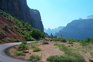
State Route 9 (SR-9) is a 57.075-mile-long (91.853 km) state highway in southern Utah, serving Zion National Park. It starts at the western terminus at exit 16 on Interstate 15 (I-15), passing through Zion National Park, and ending at the eastern junction with U.S. Route 89 (US-89). The entire length of the highway has been designated the Zion Park Scenic Byway. There is a fee to travel through Zion National Park, but the Zion-Mt. Carmel Highway is open to private vehicles year-round. A separate fee is required for vehicles 7'10" wide and/or 11'4" tall or larger. This fee pays for a park employee to stop traffic from the other side of the Zion - Mt. Carmel Tunnel to allow the larger vehicles to pass through. There is a smaller tunnel in Zion National Park that does not require an escort. Commercial vehicles are prohibited from using SR-9 and are directed to use SR-20 instead.
State Route 82 is an east–west state highway in southern Arizona. The western terminus of Route 82 is located at its junction with Business Loop 19 in Nogales and its eastern terminus at its junction with State Route 80 just north of Tombstone. Between Nogales and Patagonia, it is also known as Patagonia Road and Patagonia Highway. Other than the aforementioned locations, Route 82 also travels through Sonoita and Whetstone, and is one of the few major east–west highways in its service area.
State Route 88 is a 45.67 mi (73.50 km) long state highway in the U.S. state of Arizona. It runs from U.S. Route 60 in Apache Junction through desert terrain to SR 188 near Roosevelt Dam. Following the Salt River for much of its length, the section east of Tortilla Flat is known as the Apache Trail and is part of the National Forest Scenic Byway system. The Apache Trail was built in the mid-1920s and the number 88 was assigned in 1927. An eastern extension of SR 88 to Globe was redesignated as SR 188 on August 20, 1999.
State Route 377, also known as SR 377, is a state highway in northeast Arizona traveling from northeast to southwest; it begins at a junction with State Route 77 south of Holbrook, goes past Dry Lake, to end at State Route 277 east of Heber-Overgaard. Parts of the highway are also known as Dry Lake Road and Heber Road.
State Route 73, also known as SR 73, is a U-shaped state highway, though it is signed north–south, primarily serving the Fort Apache Indian Reservation in eastern Arizona. SR 73 begins at a junction with the U.S. Route 60 / State Route 77 concurrency near Carrizo, travels southeast to Fort Apache and Whiteriver, then bends north-northeast until intersecting State Route 260 near the Hon-Dah Resort Casino.

State Route 288 heads north from State Route 188 near Roosevelt Lake. SR 288 ends at Young south of State Route 260. Currently, most of SR 288 is unpaved.
State Route 177 or SR 177 runs in a north–south direction from Superior, Arizona to Winkelman, Arizona. It ends at two junctions, US 60 to the north and State Route 77 to the south. The southern half of this road runs alongside the Gila River and the Copper Basin Railroad.

State Route 98 is a state highway in Coconino County in the U.S. state of Arizona.

State Route 261 is a highway in Apache County, Arizona that runs from its junction with SR 260 west of Eagar to its junction with SR 273 north of Big Lake. It winds through the forest but is overall a north–south route.

State Route 273 is a state highway in Apache County, Arizona that runs from its junction with SR 260 west of Eagar to its junction with SR 261 north of Big Lake. It winds through the forest but is overall a north–south route.
State Route 264 (SR 264) is a state highway in northeastern Arizona, that runs from a junction with US 160 near Tuba City to the New Mexico state line at Window Rock, where the highway continues as New Mexico State Road 264.

State Route 289 is a highway in Santa Cruz County, Arizona that runs from its junction with Interstate 19 to the north of Nogales, to Peña Blanca Lake. It is an east–west route.
State Route 366 is a highway in Graham County, Arizona that runs from its junction with US 191 south of Safford to near the summit of Mount Graham. It is a winding mountain road with one half primarily a northwest-southeast route, the other half being northeast-southwest.
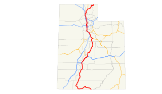
U.S. Route 89 in the U.S. state of Utah is a north–south United States Highway spanning more than 502 miles (807.891 km) through the central part of the state, making it the longest road in Utah. Between Provo and Brigham City, US-89 serves as a local road, paralleling Interstate 15, but the portions from Arizona north to Provo and Brigham City northeast to Wyoming serve separate corridors. The former provides access to several national parks and Arizona, and the latter connects I-15 with Logan, the state's only Metropolitan Statistical Area not on the Interstate.

